Pompéi (Italie): Une scène émouvante // Pompeii (Italy): A scene full of emotion

drapeau francaisEn cliquant sur ce lien, vous verrez une série très intéressante de photos publiées par The Mirror. Elle montre des archéologues en train de travailler sur les cadavres d’habitants de Pompéi victimes de l’éruption du Vésuve en 79 après JC.
http://www.mirror.co.uk/news/weird-news/terrified-mother-childs-final-moments-5733991

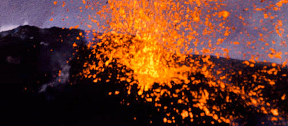
L’éruption du Vésuve a été si soudaine que l’expression de terreur se lit encore sur les visages d’une mère et de son fils au moment où ils disparaissaient sous une épaisse couche de cendre et de ponce brûlantes. La mère et son fils, qui semble être âgé d’environ 4 ans, ont passé ensemble les dernières secondes de leurs vies. Le regard terrifié du fils laisse imaginer l’événement dont ont été témoins ces êtres humains.

Selon les archéologues qui travaillent sur ce projet, le jeune garçon a probablement couru pour se blottir dans les bras de sa mère quand il a entendu le grondement de l’éruption du Vésuve. Les chercheurs ont préservé cette scène en prenant des moulages en plâtre des deux personnages.
Une étude récente a apporté des informations intéressantes, à la fois sur le nombre de victimes à Pompéi, les circonstances de leur mort et le déroulement de l’éruption. En reprenant les rapports de fouilles depuis le XVIIIe siècle, on classa les victimes en deux catégories, selon leur position stratigraphique dans les dépôts éruptifs : soit dans la couche de pierres ponces de la première phase de l’éruption, soit dans la couche de cendres provenant des nuées ardentes qui suivirent. Dans le premier groupe, on dénombre 394 corps, dont la majorité (345) à l’intérieur d’immeubles, où elles s’étaient réfugiées. Bon nombre d’entre elles furent victimes de l’écroulement des toits sous le poids des pierres ponces. Dans le deuxième groupe figurent 655 personnes. Le nombre de corps trouvés à l’extérieur est considérablement plus élevé (319). Il s’agit d’individus qui, profitant de l’accalmie de l’éruption au matin du deuxième jour, crurent pouvoir s’enfuir et furent surpris par les nuées ardentes qui suivirent. À ces 1 049 personnes (dont les trois dernières furent découvertes en 2002) il convient d’ajouter une centaine de corps à propos desquels il n’y a pas d’informations précises.

 ————————————–

drapeau anglaisBy clicking on this link, you will see a very interesting series of photos released by The Mirror showing archaeologists working on the remains of Pompeii residents who were caught in the eruption of Vesuvius in 79 AD.

http://www.mirror.co.uk/news/weird-news/terrified-mother-childs-final-moments-5733991

The eruption of Vesuvius happened so quickly that the terrified facial expressions of a mother and son were frozen in time as they were covered by burning hot ash and pumice. The mother and her son, who seems to be about 4 years old, spent their final seconds alive together. The son’s look of terror offers a window into what these human beings were witnessing that day.

Archeologists working on this project suggest it looks as if the young boy ran into his mother’s arms as he heard the rumblings of the volcano erupting. These researchers will preserve this scene by taking plaster casts of this boy and his mother.

A recent study has provided valuable information, both on the number of victims at Pompeii, the circumstances of their deaths and the course of the eruption. By resuming excavation reports since the 18th century, the victims were classified into two categories according to their stratigraphic position in the eruptive deposits: either in the layer of pumice from the first phase of the eruption, or in the ash layer from pyroclastic flows that followed. In the first group, there were 394 bodies, of which the majority (345) was in the interior of buildings where they had taken refuge. Many of them were victims of the collapse of the roof under the weight of pumice. The second group included 655 people. The number of bodies found outside is considerably higher (319). It is individuals who, taking advantage of the lull of the eruption on the morning of the second day, thought they could get away and were surprised by the puroclastic flows that followed. To these 1,049 people (the last three were discovered in 2002) should be added to a hundred bodies about which there is no precise information.

Pompei-2-blog

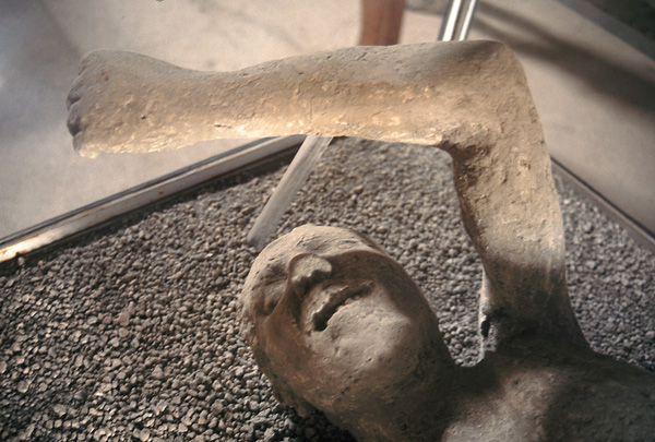
Moulage de l’une des victimes de l’éruption de l’an 79.   (Photo:  C. Grandpey)

Eruption aux Galapagos (Equateur / Ecuador)

drapeau francaisUne éruption a commencé hier soir dans les îles Galapagos. Elle se siyue sur le volcan Wolf, dans la partie nord de l’île Isabela. Le volcan (1710 mètres d’altitude) a connu sa dernière éruption en 1982, avec deux fontaines de lave et des coulées.
L’Instituto Geofisico donne sur son site quelques détails de l’éruption. Nous apprenons qu’elle a commencé au niveau d’une fracture qui s’est ouverte sur le flanc sud-est du volcan Wolf. Les premiers signaux sismiques ont été enregistrés à 23:50 (heure locale). Le panache éruptif avait une hauteur de 10 – 15 km pendant les premières heures de l’éruption.
En cliquant sur ce lien, vous pourrez voir les premières images de l’éruption et l’impact du panache éruptif sur le site de l’Institut Géophysique.
http://www.igepn.edu.ec/noticias/1007-informe-especial-galapagos-no-2-2015

Isabela, où se trouve le volcan Wolf, est l’une des plus jeunes îles de l’archipel des Galapagos. Elle est située à l’extrémité ouest, près du point chaud des Galapagos. Il y a environ un million d’années, l’île a été formée par la coalescence de 6 volcans boucliers: Alcedo, Cerro Azul, Darwin, Ecuador, Sierra Negra et Wolf, siège de l’éruption en cours. Tous ces volcans, sauf Ecuador, sont encore actifs.
Isabela est aussi intéressante pour sa flore et sa faune. L’île ne possède pas les mêmes zones de végétation que les autres îles. Les champs de lave relativement récents n’ont pas fourni les nutriments nécessaires pour permettre l’apparition des zones de vie variées que l’on rencontre ailleurs. Une autre différence concerne les volcans Wolf et Cerro Azul dont les sommets sont arides.
Isabela abrite une vie animale et marine fantastique. Elle possède plus de tortues sauvages que toutes les autres îles. Sa topographie a créé des obstacles pour les tortues de sorte que ces créatures lourdes et lentes ont été incapables de traverser les coulées de lave et franchir d’autres obstacles, ce qui a donné naissance à plusieurs sous-espèces. Isabela possède par ailleurs une colonie d’iguanes roses unique au monde. Espérons que l’éruption ne causera pas trop de dégâts à l’île. La localité de Puerto Villamil, à la pointe sud-est de l’île, n’est pas menacée par l’éruption.

 ————————————————-

drapeau anglaisAn eruption started last night in the Galapagos Islands. It is located on Wolf volcano, in the northern part of the island of Isabela. The volcano (1710 metres high) last erupted in 1982, producing both lava fountains and lava flows.

The Instituto Geofisico gives some details about the eruption. We learn that the eruption started at a new fissure on the southeast flank of Wolf volcano. The first seismic signals were recorded at 23:50 (local time). The eruptive plume was 10 – 15 km tall during the first hours of the eruption.

By clicking on this link, you will see the first images of the eruption and the impact of the eruptive plume on the website of the Geophysical Institute.

http://www.igepn.edu.ec/noticias/1007-informe-especial-galapagos-no-2-2015

Isabela, where Wolf is located, is one of the youngest Galapagos Islands.  Isabela is located on the western edge of the archipelago, near the Galapagos hotspot. About one million years ago, the island was formed by the merger of 6 shield volcanoes: Alcedo, Cerro Azul, Darwin, Ecuador, Sierra Negra and Wolf where the current eruption is taking place. All of these volcanoes except Ecuador are still active.

Isabela is also interesting for its flora and fauna. The island does not follow the vegetation zones of the other islands. The relatively new lava fields have not developed the sufficient nutrients required to support the varied life zones found on other islands. Another obvious difference occurs on Wolf and Cerro Azul volcanoes which are arid on top.

Isabela’s rich animal, bird, and marine life is fantastic. The island is home to more wild tortoises than all the other islands. Its topography created barriers so that the creatures were unable to cross lava flows and other obstacles, causing several different sub-species of tortoise to develop. Isabela also has a unique population of pink iguanas. Let’s hope the eruption will not cause too much damage to the island. Puerto Villamil, at the south-eastern tip of the island, is not threatened by the eruption.

Wolf

Source: Instituto Geofisico.

Hawaii: Bye bye Pu’u Kahauale’a !

drapeau francaisCeux qui ont visité les champs de lave de la Grande Ile d’Hawaii ont probablement vu le Pu’u Kahauale’a, un petit cône de projections avec un double cratère à son sommet, au nord-est de Pu’uO’o. Il s’est formé il y a 200 à 400 ans au cours de l’éruption du Pu`u `O`o-Kupaianaha. Le cône s’est couvert de végétation et a formé un kipuka. Il faut maintenant parler du Pu’u Kahauale’a au passé. En effet, il a été lentement recouvert par la lave du Pu’u O’o au cours de l’éruption qui dure depuis le 3 janvier 1983 et la coulée du 27 juin est en train de le faire disparaître à jamais.
Le HVO a publié deux photos du Pu’u Kahauale’a. Celle de gauche montre le cône encore couvert d’arbustes, peu de temps après la naissance de la coulée du 27 juin. L’autre photo a été prise le 22 mai dernier; on ne distingue plus que la lèvre des cratères jumeaux.
Le HVO indique des coulées de surface restent actives au NE du Pu’u O’o. Le front le plus éloigné se situe à environ 8,5 km du Pu’uO’o et met le feu à une zone de forêt arbustive.

 ——————————————

drapeau anglaisThose who have visited the lava fields of Hawaii Big Island probably saw Pu’u Kahauale’a, a small spatter cone, northeast of Pu’uO’o, which was built 200 to 400 years ago during the eruption of
Pu`u `O`o-Kupaianaha. The cone was vegetated and formed a kipuka. You now have to use the preterite to write about Pu’u Kahauale’a. Indeed, it has been buried slowly by the Pu‘u O‘o eruption that began on January 3rd 1983, and the ongoing June 27th flow has nearly finished the job.

HVO has released two photos of Pu’u Kahauale’a. The one to the left, taken in June, shows the cone still covered by a patch of trees, shortly after the latest flow started on June 27th. The other photo was taken on May 22nd; it shows only the very top of the twin craters remaining.

HVO indicates surface flows continue to be active northeast of Pu’u O’o. The most distant active tip of the June 27th flow is about 8.5 km from Pu’uO’o and burning an area of forest brush.

Puu

Source:  HVO.

Photos en meilleure résolution à cette adresse:  http://hvo.wr.usgs.gov/multimedia/uploads/multimediaFile-1195.jpg

Piton de la Fournaise (Ile de la Réunion)

drapeau francaisLe tremor continue à montrer de fortes fluctuations, avec un pic remarquable pendant la soirée du 23 mai. L’Observatoire pense que ce phénomène est peut-être lié à une intensification des fontaines de lave au niveau de la bouche éruptive et probablement du débit de la coulée de lave.

Au cours d’un survol en ULM, il a été possible de constater qu’un important panache bleu (SO2) était présent au-dessus de la bouche éruptive et  que cône de scories semblait en cours de fermeture. Les fontaines étaient réduites par rapport aux observations précédentes. Un écoulement principal était visible sur 200 mètres puis disparaissait en tunnel. Deux bouches éphémères étaient ensuite observables après respectivement environ 50 et 100 mètres d’écoulement en tunnel. Le front de lave n’a pas pu être observé.

Source: OVPF.

 —————————————————-

drapeau anglaisThe tremor continues to show strong fluctuations, with a remarkable peak during the evening of May 23rd. The Observatory believes that this phenomenon may be related to an intensification of lava fountains at the eruptive vent and probably the lava flow output.
During a microlight overflight, it was possible to see that a significant blue plume (SO2) was present above the eruptive vent and the cinder cone was about to become closed. The fountains were reduced compared to previous observations. A main flow was visible over 200 meters then disappeared into a tunnel. Two breakouts were then observed about 50 and 100 meters after the tunnel. The lava front could not be observed.

Source: OVPF.

Piton blog_modifié-1

Source:  OVPF.