![]() Voici quelques nouvelles de l’activité volcanique dans le monde :
Voici quelques nouvelles de l’activité volcanique dans le monde :
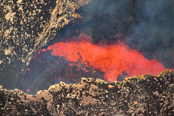
Dans son dernier rapport (10 avril 2024), le Met Office indique que l’éruption sur la péninsule de Reykjanes (Islande) se poursuit de manière relativement stable. Il n’y a aucun signe d’une diminution du débit magmatique. Il est difficile de prédire quand cette éruption prendra fin ; il se peut qu’elle se poursuive encore longtemps, ou bien qu’elle cesse soudainement.
Selon les données recueillies lors d’un survol, il apparaît que le débit d’émission de la lave a diminué. Il est passé d’environ 6,6 mètres cubes par seconde entre le 27 mars et la 3 avril à environ 3,6 mètres cubes par seconde du 3 au 8 avril. Le champ de lave actuel couvre une superficie de 6,14 kilomètres carrés. Il est donc plus étendu que lors des six éruptions précédentes sur la péninsule de Reykjanes. Ces derniers temps, la lave s’est écoulée principalement vers le sud depuis la bouche éruptive, mais elle s’est temporairement écoulée vers le nord lorsque la paroi du cratère s’est effondrée il y a quelques jours. Rien n’indique que la lave se déplace le long des digues de terre au nord de Grindavík.
L’inflation du sol se poursuit dans le secteur de Svartsengi et s’est accélérée au cours de la semaine dernière, alors que l’intensité de l’éruption diminuait. Cela signifie que la plus grande partie du magma qui circule sous la région de Svartsengi s’y accumule, provoquant une augmentation de la pression et donc de l’inflation.
Il existe un risque de pollution par les gaz dans toutes les zones proches de l’éruption. Le Blue Lagoon est resté fermé le 11 avril à cause de cette pollution.
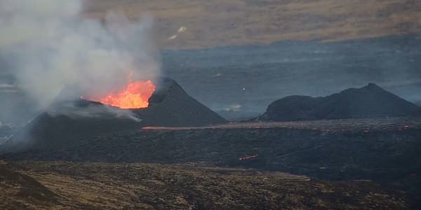
Image webcam de la bouche active sur la fracture éruptive
++++++++++
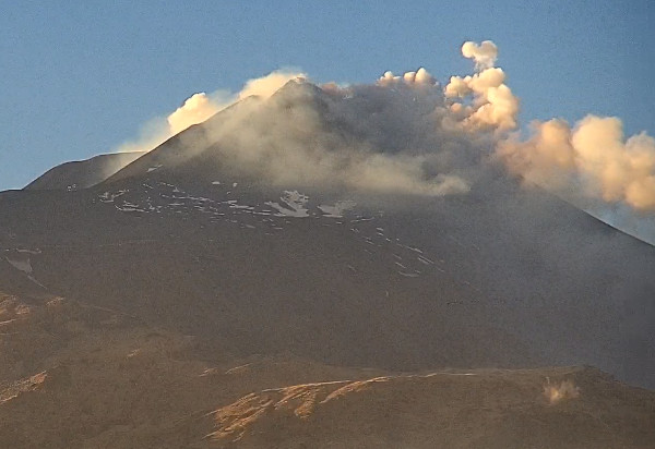
Ces derniers jours, l’activité sur l’Etna (Sicile) a été marquée par l’émission de nombreux anneaux de fumée à partir d’une petite bouche dans le Cratère sud-est. Le 2 avril 2024, l’INGV a fait passer la couleur de l’alerte aérienne au Jaune (niveau 2 sur une échelle de quatre couleurs) en raison d’une hausse de l’activité. La couleur est ensuite passée à l’Orange dans la soirée car une activité explosive était visible au niveau des cratères sommitaux sur les images des webcams.
Une série de six événements explosifs a été enregistrée par le réseau sismique le 7 avril. Pendant quatre minutes, des émissions de cendres provenant de la Bocca Nuova sont montées à environ 1,6 km au-dessus du sommet avant de se disperser vers le sud.
Source : INGV.
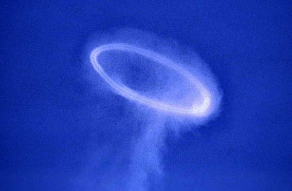
Anneau de fumée sur l’Etna (Photo: C. Grandpey)
++++++++++
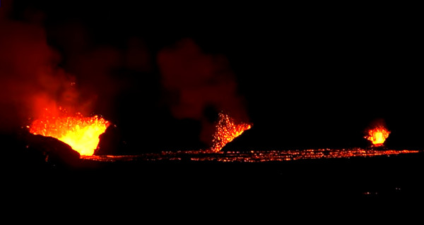
L’Instituto Geofisico indique qu’entre le 2 mars et le 1er avril 2024, environ 44 millions de mètres cubes de lave ont été émis sur l’île Fernandina (Galapagos). L’éruption actuelle est donc la plus importante des 15 dernières années. La Fracture 13, située juste en dessous de la lèvre du cratère sur le flanc supérieur SE, est toujours active en avril, avec un débit d’environ cinq mètres cubes par seconde. Les coulées de lave ont atteint l’océan le 7 avril, comme on peut le voir sur plusieurs photos et vidéos sur les réseaux sociaux.
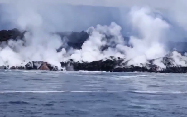
Image extraite d’une vidéo parue sur Twitter
++++++++++
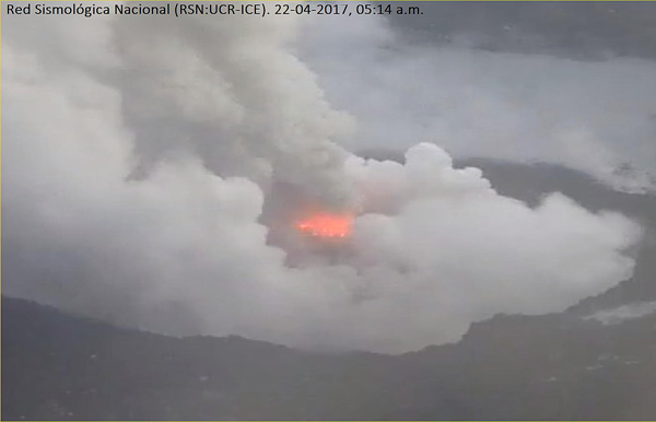
L’activité éruptive se poursuit sur le Poás (Costa Rica) avec des panaches de gaz et de vapeur qui s’élèvent à quelques centaines de mètres au-dessus du cratère. L’incandescence était visible au niveau de la Boca A et de la Boca C les 3 et 4 avril, et dans la Boca A les 4 et 5 avril. Une odeur de soufre a été signalée dans plusieurs localités. Les conditions météorologiques ont parfois empêché de faire de bonnes observations.
Source : OVSICORI.
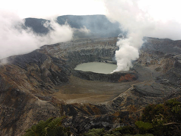
Cratère du Poás (Crédit photo: OVSICORI)
++++++++++
L’éruption du Dukono (Halmahera / Indonésie) se poursuit. Les panaches de cendres s’élèvent jusqu’à 1,6 km au-dessus du sommet. Le niveau d’alerte reste 2 (sur une échelle de 1 à 4) et le public est prié de rester en dehors de la zone d’exclusion de 3 km.
Toujours en Indonésie, l’activité éruptive se poursuit sur le Marapi (Sumatra) avec des panaches de cendres qui s’élèvent de 250 à 1 500 m au-dessus du sommet.
Des lahars générés par des pluies intenses ont été détectés par le réseau sismique le 5 avril 2024. Ils ont dévalé plusieurs ravines et ont endommagé des maisons et des infrastructures dans plusieurs villages. Une route a également été endommagée et est devenue impraticable pendant plusieurs heures. Les lahars ont envahi quelque 65 hectares de rizières, endommagé 72 maisons et affecté 38 entreprises. Dans certaines zones, des voitures ont été bloquées et des automobilistes ont été coincés à l’intérieur ; des stations-service ont été touchées et des animaux ont été emportés dans des fermes. Certains habitants ont été transportés à l’hôpital, mais aucun décès n’a été signalé. Des travaux sont en cours pour éliminer les dépôts de lahars tels que les troncs d’arbres et les branches. Le niveau d’alerte volcanique reste à 3 (sur une échelle de 1 à 4) et le public est prié de rester à 4,5 km du cratère actif.
Source : PVMBG.
++++++++++
L’activité éruptive est toujours intense sur le Sangay (Equateur). Le réseau sismique a enregistré 1 106 explosions les 2 et 3 avril 2024. Les panaches de gaz et de cendres s’élèvent de 300 à 1 000 m au-dessus du sommet. Des matériaux incandescents dévalent le flanc SE jusqu’à 600 m de distance. Le niveau d’alerte reste au Jaune (niveau 2 sur une échelle à quatre couleurs).
Source : Instituto Geofisico.
++++++++++
Une lente émission de lave se poursuit dans le cratère sommital du Great Sitkin (Aléoutiennes / Alaska). Des températures de surface légèrement élevées sont visibles sur l’imagerie satellite. La sismicité est faible. Le niveau d’alerte volcanique reste à Watch [Vigilance] (niveau 3 sur une échelle de quatre niveaux) et la couleur de l’alerte aérienne est maintenue à l’Orange.
Source : AVO.
++++++++++
Dernière minute : Une éruption phréatique s’est produite sur le Taal (Philippines) dans la soirée du 11 avril 2024 avec un panache de vapeur de 2,4 km de haut. L’éruption a probablement été déclenchée par la libération continue de gaz volcaniques à haute température au niveau du Main Crater, avec le risque qu’une activité phréatique similaire se reproduise.
Malgré cette intensification de l’activité, le niveau d’alerte volcanique reste à 1, ce qui signifie qu’il existe un risque de possibles explosions phréatiques soudaines, de séismes d’origine volcanique, de retombées de cendres mineures et d’émissions de gaz nocifs. Le PHIVOLCS déconseille fortement d’entrer dans la Zone de Danger Permanente (PDZ), notamment dans le secteur du Main Crater.
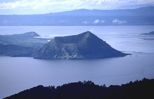
Crédit photo: Wikipedia
++++++++++
L’activité reste globalement stable sur les autres volcans mentionnés dans les bulletins précédents « Volcans du monde ». .
Ces informations ne sont pas exhaustives. Vous pourrez en obtenir d’autres en lisant le rapport hebdomadaire de la Smithsonian Institution :
https://volcano.si.edu/reports_weekly.cfm
°°°°°°°°°°
Flux RSS
Petit rappel : on me demande parfois comment il est possible de recevoir et lire mes articles au moment de leur parution. Pour cela, rendez-vous en haut de la colonne de droite de mon blog où figure le flux RSS qui permet de recevoir automatiquement des mises à jour du blog.
Vous pouvez également cliquer sur « Suivre Claude Grandpey : Volcans et Glaciers ».
——————————————-
![]() Here is some news of volcanic activity around the world :
Here is some news of volcanic activity around the world :
In its latest report (April 10th, 2024), the Met Office indicates that the eruption on the Reykjanes Peninsula (Iceland) is continuing in a fairly stable way. There are no signs of a decrease in the magma flow from the depths. It is difficult to predict when this eruption will end, it could continue for a longer period with stable flow or stop shortly.
According to data collected during an overflight, it appears that the average lava effusion rate has decreased from about 6.6 cubic meters per second during 27 March-3 April to about 3.6 cubic meters per second during 3-8 April. The lava field covers an area of 6,14 square kilometers. The current eruption has therefore become more extensive than the previous six eruptions on the Reykjanes peninsula. Recently, lava has flowed mostly to the south from the crater, but temporarily it flowed to the north when the crater’s wall collapsed a few days ago. There are no clear signs of lava flowing along the defensive walls north of Grindavík.
Inflation in Svartsengi continues and has increased in speed in the past week, while the intensity of the eruption has decreased. This indicates that the majority of magma flowing under the Svartsengi area is accumulating there, causing increased pressure and inflation.
There is a risk of gas pollution in all areas close to the eruption. The Blue Lagoon remained closed on April 11th because of this pollution.
++++++++++
Activity at Mt Etna (Sicily) was characterised by the emission of numerous smoke rings from a small vent in the Southeast Crater. On April 2nd, 2024, INGV raised the Aviation Color Code to Yellow (tlevel 2 on a four-color scale) due to increased signs of unrest. The Aviation Color Code was next raised to Orange in the vening because explosive activity at the summit craters was visible in webcam images.
A series of six explosive events was recorded by the seismic network on 7 April. A four-minute-long ash emission from Bocca Nuova rose to about 1.6 km above the summit, and quickly dispersed to the south.
Source : INGV.
++++++++++
The Instituto Geofisico has reported that between March 2nd and April 1st, 2024, an estimated 44 million cubic meters of lava had erupted at Fernandina (Galapagos) , making the current eruption the largest in the last 15 years. Fissure 13, located just below the crater rim on the upper SE flank, continued to be active in April; the rate of lava effusion is about five cubic meters per second. The lava flows reached the ocean on April 7th, as can be seen on several videos on the social networks.
++++++++++
Eruptive activity continues at Poás (Costa Rica) with vigorous emissions of gas and steam plumes rising a few hundred meters above the crater rim. Incandescence was visible from Boca A and Boca C during 3-4 April, and at Boca A during 4-5 April. A sulfur odor was reported in several communities. Weather conditions sometimes prevented visual observations.
Source : OVSICORI.
++++++++++
The eruption of Dukono (Halmahera / Indonesia) continues. Ash plumes rise as high as 1.6 km above the summit. The Alert Level remains 2 (on a scale of 1-4), and the public is asked to remain outside of the 3-km exclusion zone.
Still in Indonesia, eruptive activity continues at Marapi (Sumatra) with ash plumes that rise 250-1,500 m above the summit.
Lahars generated by intense rainfall were detected by the seismic network on April 5th, 2024. They travelled in multiple drainages on Marapi and damaged homes and infrastructure in severalvillages. A highway was also damaged and became impassible for several hours. The lahars infiltrated about 65 hectares of rice fields, damaged 72 houses, and affected 38 businesses. In some areas, cars were stranded and some motorists were trapped, smaller roads were blocked, gas stations were impacted, and a few farm animals were swept away. Some residents were taken to the hospital, but no fatalities were reported. Efforts are underway to remove the debris deposits such as tree trunks and branches. The Volcano Alert Level remains at 3 (on a scale of 1-4), and the public is asked to stay 4.5 km away from the active crater
Source : PVMBG.
++++++++++
Eruptive activity is still high at Sangay (Ecuador). The seismic network recorded 1,106 explosions during 2-3 April 2024. Gas-and-ash plumes rise 300-1,000 m above the summit. Incandescent material descend the SE flank as far as 600 m. The Alert Level remains at Yellow (level 2 on a four-color scale).
Source : Instituto Geofisico.
++++++++++
Slow lava effusion continues in Great Sitkin’s summit crater (Aleutians / Alaska). Slightly elevated surface temperatures are identified in satellite imagery. Seismicity is low. The Volcano Alert Level remains at Watch (level 3 on a four-level scale) and the Aviation Color Code is kept at Orange.
Source : AVO.
++++++++++
Last minute : A phreatic eruption occurred at Taal Volcano (Philippines)in the vening of April 11th, 2024 with a 2.4 km tall steam plume. The eruption is believed to have been triggered by the ongoing release of hot volcanic gases from the Taal Main Crater, indicating that further similar phreatic activity could follow.
Despite this activity, the Volcano Alert level remains at 1, which warns of the potential for sudden phreatic explosions, volcanic earthquakes, minor ashfall, and hazardous gas emissions. PHIVOLCS strongly advises against entering the Permanent Danger Zone (PDZ), especially near the Main Crater.
++++++++++
Activity remains globally stable on other volcanoes mentioned in the previous bulletins « Volcanoes of the world ». .
This information is not exhaustive. You can find more by reading the Smithsonian Institution’s weekly report:
https://volcano.si.edu/reports_weekly.cfm
°°°°°°°°°°
RSS feed
Quick reminder: I am sometimes asked how it is possible to receive and read my posts when they are published. Just go to the top of the right column of my blog where you can see the RSS feed. It will allow you to automatically receive updates from the blog.
You can also click on “Suivre Claude Grandpey: Volcans et Glaciers”.