 08h00 (heure française): L’éruption se poursuit dans les Leilani Estates et Lanipuna Gardens. La Fracture n° 8 continue d’alimenter une impressionnante coulée qui avance en chenal le long de la Highway 132, la route qui relie Pahoa à Kapoho.
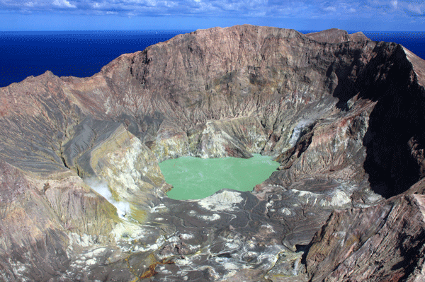
Comme on pouvait le prévoir, la lave a traversé Government Beach Road et la Highway 137 à 9h45 le 2 juin et a recouvert le carrefour de Four Corners. La coulée avance maintenant vers l’aval, en direction de l’océan, dans Kapoho Beach Lots. A 10 heures (heure locale), la lave est entrée dans le Green Lake à l’intérieur du Kapoho Crater en donnant naissance à un volumineux panache de vapeur. A 13h30, le panache avait disparu. A 15 heures la lave avait envahi le lac et toute l’eau s’était évaporée!
Depuis que la lave a traversé la Highway 137, il n’y a plus accès à Kapoho, Vacationland, la Highway 132 et la Highway 137. Cependant, Government Beach Road, entre Kahakai Boulevard et Cinder Road, reste ouverte aux habitants de Waa Waa et Papaya Farms Road uniquement s’ils possèdent des autorisations.
L’envahissement du carrefour de Four Corners par la lave s’est produit après deux jours d’évacuations dans un secteur où il y a jusqu’à 500 maisons. Ces structures sont maintenant isolées car dépourvues d’accès par la route.
Source: Protection Civile.
Le Boston Globe a publié une série d’une quarantaine d’images montrant l’éruption du Kilauea. Comme d’habitude, la qualité est au rendez-vous :
°°°°°°°°°°
21h00 (heure française): Le HVO indique que l’éruption se poursuit dans la Lower East Rift Zone. La Fracture n° 8 alimente une importante coulée canalisée qui longe la Highway 132. Après avoir traversé Government Beach Road et la Highway137, la lave descend vers l’océan dans Kapoho Beach Lots et, le matin du 3 juin, elle a atteint Kapoho Kai Road au sud et Iliani Road à l’est.
Suite à la condamnation par la lave de la Highway 137, les mesures suivantes sont en vigueur: L’accès est impossible à Kapoho, Vacationland, la Highway 132 et la Highway 137. Government Beach Road entre Kahakai Boulevard et Cinder Road, est accessibles aux habitants de Wa’a Wa’a et de Papaya Farms Road uniquement s’ils possèdent des autorisations officielles.
°°°°°°°°°°
23 heures (heure française): Comme je l’ai écrit précédemment, une douzaine de personnes ont refusé de quitter la zone de Kapoho malgré les avertissements de la Protection Civile et un ordre d’évacuation obligatoire. Dans la matinée du 3 juin, les sauveteurs ont récupéré à l’aide d’un hélicoptère trois personnes qui se trouvaient dans des zones isolées. L’activité éruptive avait coupé l’accès à Kapoho et à Vacationland.
Les habitants ont été prévenus que s’ils restaient dans des zones menacées par la lave, ils pourraient ne pas être secourus et pourraient être tenus responsables du coût de leur évacuation ; ils pourraient également être arrêtés et accusés d’avoir refusé de quitter les lieux.
La Protection Civile demande aux personnes qui peuvent confirmer que quelqu’un est encore présent dans les zones «actives et isolées» d’appeler le 935-0031.
Source: HVO et Protection Civile.
——————————————
 8:00 a.m. (French time): The eruption is continuing in Leilani Estates and Lanipuna Gardens. Fissure 8 keeps feeding a large channelized flow traveling along Highway 132, the Pahoa-Kapoho Road.
As could be predicted, lava crossed Government Beach Road and Highway 137 at 9:45 a.m. on June 2nd and inundated the Four Corners intersection. The flow is moving downslope toward the ocean into Kapoho Beach Lots. At 10 a.m. (local time), lava entered Green Lake within Kapoho Crater producing a large steam plume. By 1:30 p.m., the steam plume had ceased and by 3 p.m. lava had filled the lake and apparently evaporated all the water!
Due to lava crossing Highway 137, there is no access to Kapoho, Vacationland, Highway 132, and Highway 137. However, Government Beach Road, between Kahakai Boulevard and Cinder Road, is open to Waa Waa and Papaya Farms Road residents only with official credentials.
The crossing occurred after about two days of evacuations in the area, where there are up to 500 homes. Those structures are now isolated.
Source: Civil Defense.
The Boston globe has released a series of 40 high quality photos of the Kilauea eruption:
°°°°°°°°°°
9:00 p.m. (French time): HVO reports that the eruptionn continues throughout the Lower East Rift Zone. Fissure 8 is feeding a large channelized flow traveling along Highway 132. After having crossed Government Beach Road and Highway 137, lava is moving downslope toward the ocean into Kapoho Beach Lots and on the morning of June 3rd had reached Kapoho Kai Road to the south and Iliani Road to the east.
Due to lava crossing Highway 137, the following policies are in effect: There is no access to Kapoho, Vacationland, Highway 132 and Highway 137. Government Beach Road, between Kahakai Boulevard and Cinder Road, is open to Wa‘a Wa‘a and Papaya Farms Road residents only with official credentials.
°°°°°°°°°°
11 p.m. (French time): As I put it before, a dozen persons refused to evacuate the Kapoho area despite the Civil Defense warnings and a mandatory evacuation order. On the morning of June 3rd, the Hawaii County Fire Department rescued three people via helicopter in isolated areas as the eruption activity had cut off access to Kapoho and Vacationland.
Residents had been warned that that if they stayed in lava-affected areas, they might not be rescued and might be held responsible for the cost of their rescue and could also be subject to arrest and charges for refusing to evacuate.
Civil Defense is asking those who can confirm anyone is staying in the “active, isolated” areas to call them at 935-0031.
Source : HVO & Civil Defense.
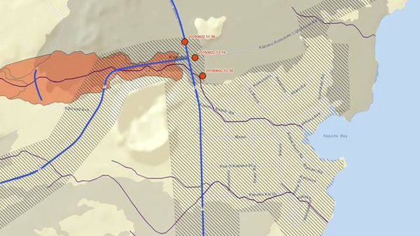
La lave a traversé le carrefour de Four Corners. Les trois points rouges correspondent aux fronts de coulées (Source: Protection Civile)