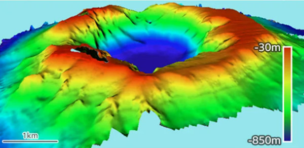
 Des chercheurs viennent de terminer la cartographie du cratère du Hunga-Tonga Hunga-Ha’apai, le volcan sous-marin de l’archipel des Tonga qui, le 15 janvier 2022, a produit l’une des plus grandes explosions atmosphériques jamais observées sur Terre. La caldeira mesure maintenant 4 km de large et descend à 850 m sous le niveau de la mer. Avant l’éruption, la base du volcan était à une profondeur d’environ 150m. Le volume de matière émis est estimé à au moins 6,5 km3.
Des scientifiques de l’Université d’Auckland (Nouvelle-Zélande) ont publié un rapport qui analyse le processus éruptif et formule des recommandations pour la résilience future. Là encore, on remarquera que les scientifiques sont capables de décrire l’éruption, mais que personne n’a jamais été en mesure de la prévoir.
Bien qu’il soit peu probable que le Hunga-Tonga Hunga-Ha’apai (HTHH) produise une éruption semblable avant plusieurs siècles, il ne faudrait pas oublier qu’il existe au moins 10 volcans sous-marins dans cette région du Pacifique sud-ouest. Eux aussi pourraient entrer violemment en éruption sur une échelle de temps plus brève.
L’Institut national de recherche sur l’eau et l’atmosphère (NIWA) de Nouvelle-Zélande a publié une carte bathymétrique de la zone autour du volcan. Une comparaison avec les cartes de la caldeira, réalisées en 2015 et 2016, donc avant l’éruption, montre des changements majeurs.
En plus d’un approfondissement général de la caldeira, de grosses parties des parois intérieures de la falaise ont disparu, en particulier à l’extrémité sud du cratère. Cependant, le cône du volcan tel qu’il se présente aujourd’hui semble structurellement solide. La caldeira est un peu plus grande en diamètre et un peu moins profonde à cause des effondrements des côtés vers l’intérieur. Le côté nord-est semble un peu mince et fragile; s’il lâchait prise, un tsunami mettrait en danger les îles Ha’apai, mais la structure du volcan semble globalement assez robuste.
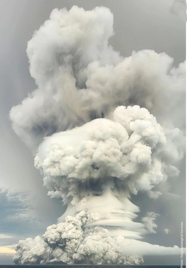
Les scientifiques commencent à avoir une bonne idée du processus éruptif. Les très nombreuses données d’observation obtenues le15 janvier montrent que l’événement a connu une surcharge dans la demi-heure après 17h00 (heure locale).
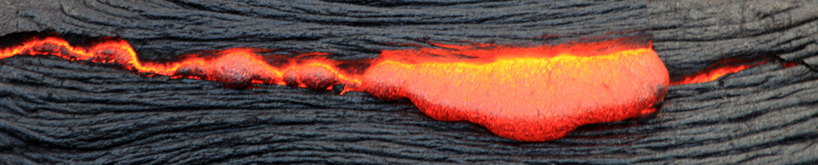
Au fur et à mesure que la caldeira s’est fracturée, l’eau de mer a commencé à interagir avec le magma à haute température qui se décompressait en remontant des profondeurs. Il y a eu des explosions assourdissantes causées par des interactions entre le magma et l’eau à grande échelle.
Les scientifiques néo-zélandais insistent sur l’importance des coulées pyroclastiques au cours de l’éruption. Les nuages de cendres et de roches très denses projetés dans le ciel sont retombés et ont roulé sur les flancs du volcan et sur le fond de l’océan. Ils sont en grande partie à l’origine des vagues de tsunami qui ont déferlé sur les côtes de l’archipel des Tonga. Ces vagues de tsunami atteignaient 18 m de hauteur à Kanokupolu, à l’ouest de Tongatapu (65 km au sud du HTHH) ; 20m de haut sur l’île Nomukeiki (une distance similaire mais au nord-est); 10m de haut sur les îles à des distances supérieures à 85 km du volcan.
Source : Université d’Auckland, NIWA.
—————————————–
 Researchers have just finished mapping the crater of Hunga-Tonga Hunga-Ha’apai, the underwater Tongan volcano that, on January 15th, 2022, produced one of Earth’s biggest atmospheric explosions. The caldera of the volcano is now 4km wide and drops to a base 850m below sea level. Before the eruption, the base was at a depth of about 150m. The volume of material ejected by the volcano can thus be estimated at least 6.5 cubic km.
Scientists from the University of Auckland (New Zealand) have issued a report which assesses the eruption and makes recommendations for future resilience. Here again, we can notice that we are able to describe the eruption but nobody was ever able to predict it.
Although Hunga-Tonga Hunga-Ha’apai (HTHH) is unlikely to give a repeat performance for many hundreds of years, there are at least 10 volcanic seamounts in the wider region of the south-west Pacific that could produce something similar on a shorter timescale.
New Zealand’s National Institute for Water and Atmospheric (NIWA) Research has released a bathymetry map for the area immediately around the volcano. A comparison with pre-eruption maps of the caldera, made in 2016 and 2015, shows the major changes.
In addition to a general deepening, big chunks have been lost from the interior cliff walls, particularly at the southern end of the crater. However, the volcano cone as it stands today looks structurally sound. The caldera is a little bigger in diameter and a little shallower as the sides collapse inwards. The north-eastern side looks a bit thin and if that failed, a tsunami would endanger the Ha’apai islands. But the volcano’s structure looks quite robust.
Scientists are beginning to get a good idea of how the eruption progressed. The wealth of observational data from January 15th suggests the event became supercharged in the half-hour after 17:00 (local time).
As the caldera cracked, seawater was able to interact with decompressing hot magma being drawn up rapidly from depth. There were sonic booms caused by large-scale magma-water interactions.
NZ scientists insist on the significance of pyroclastic flows in the eruption. These thick dense clouds of ash and rock thrown into the sky fell back to roll down the sides of the volcano and along the ocean floor. They caused much of the tsunami wave activity that inundated coastlines across the Tongan archipelago. The tsunami waves were 18m high at Kanokupolu, on western Tongatapu (65km south of HTHH); 20m high on Nomukeiki Island (a similar distance but to the north-east); 10m high on islands at distances greater than 85 km from the volcano.
Source: University of Auckland, NIWA.
Source: Université d’Auckland
Source: Tonga Services