Volcan de boue au Guatemala // Mud volcano in Guatemala

On peut regarder sur YouTube un clip réalisé le 13 janvier 2019 à Santa Rosa, dans le sud du Guatemala. On y voit un cratère renfermant une mare de boue très active. Il est apparu dans un lagon très fréquenté par les touristes. La vidéo montre plusieurs personnes autour du cratère d’où s’échappe également du gaz. Les autorités étudient actuellement le cratère pour savoir s’il fait partie d’une nouvelle activité volcanique susceptible d’affecter le tourisme dans la région.
Les volcans de boue – parfois appelés marmites du diable – sont assez répandus dans les régions volcaniques. La boue se forme principalement lorsque l’eau, qui a été chauffée sous terre, commence à se mélanger avec des matériaux. Ces derniers sont ensuite poussés vers la surface par la pression de gaz en empruntant généralement une faille ou une fracture géologique. La température de la boue atteint généralement une centaine de degrés. C’est la température que j’avais mesurée dans des volcans de boue en aval de la Dragon’s Mouth à Yellowstone il y a quelques années. Le gaz émis est principalement du méthane, ce qui explique les explosions qui peuvent se produire sur les sites. De telles explosions ont été observées le 11 août 2008 dans les Maccalube di Aragona en Sicile. Elles ont tué deux enfants en septembre 2014.
Voici une vidéo du volcan de boue au Guatemala:

https://www.msn.com/en-au/video/lifestyle/guatemalan-authorities-investigate-new-volcanic-crater-in-tourist-hot-spot-lagoon/vp-BBSdrVk?fbclid=IwAR3ei6yX5dqcxEQToZ44Vm0Qb9SGVd36eJ9abbMlAFLOpk9VGMvQssvU3Ro

————————————————–

One can watch on YouTube a clip that was captured on January 13th, 2019 in Santa Rosa, southern Guatemala. It shows a crater with a very active mud pool that has appeared in a lagoon popular for tourists. The footage shows a crowd watching the crater spewing mud and gas up into the air. Authorities are investigating if the crater could be part of a new volcano activity that could affect tourism in the area.

Mud volcanoes – sometimes called devil’s caldron – are fairly common in volcanic areas. The mud is mostly formed as hot water, which has been heated deep below the Earth’s surface, begins to mix and blend with subterranean mineral deposits. This material is then forced upwards under the pressure of gases through a geological fault or fissure. The temperature of the mud usually reaches about 100°C. This was the temperature I measured near Dragon’s Mouth at Yellowstone a few years ago. Most of the gas released from mud cauldrons is methane, which accounts for the explosions that may occur on the sites. Such explosions were observed on August 11th, 2008 at the Maccalube di Aragona in Sicily. They killed two children in September 2014.

Here is a video of the mud caldron in Guatemala:
https://www.msn.com/en-au/video/lifestyle/guatemalan-authorities-investigate-new-volcanic-crater-in-tourist-hot-spot-lagoon/vp-BBSdrVk?fbclid=IwAR3ei6yX5dqcxEQToZ44Vm0Qb9SGVd36eJ9abbMlAFLOpk9VGMvQssvU3Ro

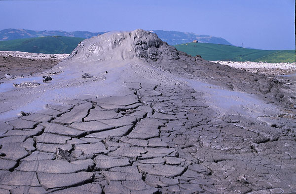
Volcan de boue sur le site des Maccalube di Aragona (Sicile)
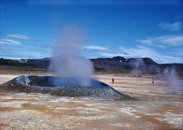
« Marmite du diable » à Namaskard (Islande)

[Photos: C. Grandpey]
Mt Shindake (Japon / Japan)

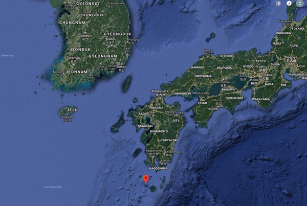
Selon une dépêche de l’agence Associated Press, le volcan Shindake sur l’île de Kuchinoerabu est entré en éruption le 17 janvier 2019, avec des projections de blocs et de cendre, sans toutefois causer de dégâts ou de blessures.
L’Agence météorologique japonaise a déclaré que les matériaux éjectés n’avaient pas atteint la zone habitée située à 2 kilomètres du volcan. Environ 80 habitants sont allés immédiatement se réfugier dans un abri sur l’île et sont ensuite rentrés chez eux après la levée de l’avis d’évacuation moins de deux heures après l’éruption.
La dernière éruption majeure du Shindake, en mai 2015, avait déplacé temporairement toute la population de l’île, soit environ 150 personnes. Les habitants ont été évacués vers l’île de Yakushima, à environ 12 kilomètres à l’est. Seuls les deux tiers environ d’entre eux sont depuis rentrés à Kuchinoerabu qui se trouve au sud de Kyushu.
Source: The Seattle Times, Associated Press. .
NDLR: Une autre éruption, moins puissante, a également été observée dans l’après-midi du 18 décembre 2018, avec des panaches de cendre s’élevant jusqu’à 2 000 mètres au-dessus du cratère (voir article sur ce blog  le 18 décembre 2018). Une coulée pyroclastique avait dévalé sur environ 1 km sur le flanc ouest du volcan. Il s’agissait de la première coulée de ce type depuis mai 2015.

————————————————-

According to an Associated Press report, Shindake volcano on Kuchinoerabu Island erupted on January 17th, 2019, blasting rocks and ash into the air but causing no damage or injuries.

The Japan Meteorological Agency said the ejected materials have not reached the residential area 2 kilometres away. About 80 residents initially took refuge at a shelter on the island but have since started to return home after an evacuation advisory was lifted less than two hours after the eruption.

Shindake’s last major eruption in May 2015 had temporarily displaced the island’s entire population of about 150. The residents were evacuated to Yakushima Island, about 12 kilometres to the east. Only about two thirds of them had since returned to Kuchinoerabu, south of Kyushu.

Source: The Seattle Times, Associated Press. .

Personal note: Another, less powerful, eruption was also observed during the afternoon of December 18th, 2018, with ash plumes rising up to 2 000 metres above the crater (see post on this blog). A pyroclastic flow had reached a distance of about 1 km down the western slope of the volcano. It was the first such flow to be observed since May 2015.

En rouge l’île Kuchinoerabu, au sud de Kyushu, où se dresse le Mt Shindake (Google Maps)

Sabancaya (Pérou / Peru)

Le dernier bulletin de l’Institut de Géophysique du Pérou nous apprend que l’éruption du Sabancaya se poursuit sans changements significatifs. On enregistre en moyenne une vingtaine d’événements explosifs chaque jour. Les sismographes confirment que ces explosions sont essentiellement liées à des mouvements de fluides et que la sismicité n’est pas provoquée par une ascension de magma. Les nuages de cendre atteignent une hauteur de 3500 mètres. On ne relève pas de déformation majeure de l’édifice volcanique.

Source : IGP, INGEMMET.

————————————————

The latest report of the Institute of Geophysics of Peru informs us that the eruption of Sabancaya continues without significant changes. On average, there are about twenty explosive events every day. The seismographs confirm that these explosions are essentially related to fluid movements and that the current seismicity is not caused by magma ascent. The ash plumes reach a height of 3500 metres above the crater. There is no major deformation of the volcanic edifice.
Source: IGP, INGEMMET.

Source: INGEMMET

Anak Krakatau : Une histoire de survie // Surviving Anak Krakatau

On peut lire sur le site web The Watchers un article très intéressant sur la récente éruption de l’Anak Krakatau. L’article est illustré de photos prises par James Reynolds de EarthUncutTV qui s’est rendu dans le secteur de l’Anak Krakatau le 10 janvier 2019, deux semaines après l’éruption et le tsunami dévastateur du 22 décembre 2018. Les photos montrent les profonds changements subis par le volcan.
Il y a également une vidéo en accéléré illustrant l’activité phréatomagmatique du 4 janvier 2019.
Une autre vidéo est l’interview d’un pêcheur indonésien qui se trouvait à proximité de l’Anak Krakatau lors de l’effondrement et du tsunami du 22 décembre. Son récit est poignant et met en lumière ce qui s’est passé sur le volcan ce jour-là. Il explique que l’éruption observée vers 20 heures était différente de celles qu’il avait vues auparavant et qu’elle a atteint son point culminant avant le tsunami. La foudre était présente sur le volcan. Il a pêché beaucoup de poissons ce jour-là, beaucoup plus que la normale. Cependant, à cause de la situation qui empirait, les pêcheurs ont décidé de rentrer chez eux plus tôt que prévu. Soudain, des vagues énormes sont arrivées sans prévenir. Le pêcheur a dit qu’il avait vu l’île de Sertung (à 3 km de l’Anak Krakatau) se faire submerger par les eaux. Il y a peut-être eu jusqu’à quatre vagues. Selon lui, l’une d’elle mesurait probablement 25 mètres de haut, car elle était plus grande que les arbres de l’île. Il pouvait voir clairement l’événement, car la lune éclairait le ciel ce soir-là.
Un autre pêcheur a confirmé que deux des vagues du tsunami étaient particulièrement grosses. Il a été jeté à la mer. L’eau s’est retirée et une autre vague a frappé. Il pensait qu’il allait mourir. Lui et son ami se sont rendus sur l’île de Sertung. Il est monté dans la forêt et il s’est attaché à un arbre avec une corde et y est resté toute la nuit, jusqu’au matin. Le lendemain matin, il s’est aperçu que quelques autres pêcheurs avaient survécu eux aussi. Ils sont restés sur l’île de Sertung pendant 5 jours. Ils avaient très faim et ont mangé des noix de coco pour survivre. La matinée du dernier jour, ils ont décidé d’essayer de nager jusqu’à l’île Sebesi, qui était la plus proche. Ils ont fabriqué un radeau é l’aide de débris d’arbres pour pouvoir s’y accrocher. Ils ont atteint Sebesi le lendemain matin. Seulement 3 d’entre eux ont réussi à atteindre l’île car un pêcheur est tombé et a péri en mer. Selon le premier pêcheur interrogé, il y avait 15 pêcheurs dans le secteur de l’Anak Krakatau le jour du tsunami. Sept sont rentrés chez eux, un est décédé et sept autres sont portés disparus.
Source: The Watchers.

——————————————————-

One can read on the website The Watchers a very interesting article about the recent eruption of Anak Krakatau. The article is illustrated with photos taken by James Reynolds of EarthUncutTV who visited Anak Krakatau on January 10th, 2019, two weeks after the recent eruptions and devastating tsunami of December 22nd, 2018.  The photos show the deep changes undergone by the volcano.

There is also a time lapse video that shows the phreatomagmatic activity on January 4th, 2019.

The other video is an interview with an Indonesian fisherman who was at Krakatau during the collapse and tsunami on December 22nd, 2018. His account is frightening, but also sheds important light on details on what happened at Anak Krakatau that day. He said the eruption of Krakatau climaxed before the tsunami, and that the eruption around 20:00 in the evening became different from what they had seen before. Lightning was produced by the volcano. He got a lot of fish this day, much more than normal. However, because of the condition, the fishermen decided to return home early. Suddenly, huge waves arrived without warning. The fisherman said he could see Sertung Island (3 km from Anak Krakatau) become engulfed in water. There may have been as many as four waves. He said one of them was probably 25 metres tall, as it was taller than the trees on the island. He could see the event clearly, as the moon was up that evening.

Another fisherman confirmed that two of the tsunami waves were particularly big. He was thrown out at sea. The water receded, and another wave hit. He thought he was going to die. He and his friend made it to Sertung Island. He went up the forest and he used a rope to tie himself to a tree, and stayed there all night until the morning. Next morning he found that few other fishermen had also survived. They stayed on Sertung Island for 5 days. They were starving, surviving on coconuts. On the last day in the morning, the four of them decided to try to swim to Sebesi Island, the closest inhabited island. They made a raft made of tree-debris so they could hold on to. They reached Sebesi the next morning. Only 3 of them made it, one got separated and perished at sea. According to the first fisherman in the interview,, there were 15 fishermen at Krakatau on the day of the tsunami. 7 have returned home, 1 died and 7 others are missing.

Source: The Watchers.

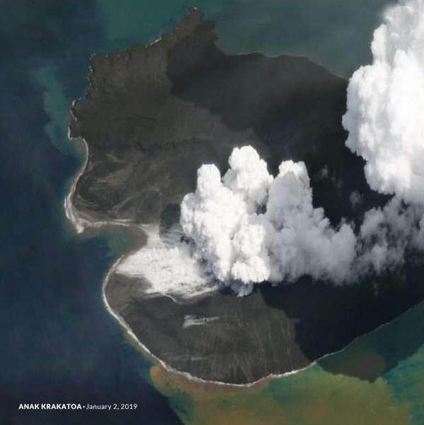
 L’Anak Krakatau vu depuis l’espace le 2 janvier 2019 (Source: Planet labs)