 Comme je l’ai écrit dans une note précédente, le Manaro Voui est en alerte de niveau 3 sur une échelle de cinq et représente toujours une menace pour la santé des habitants de l’île que le gouvernement encourage à évacuer. Le volcan est entré en éruption en septembre 2017, provoquant une brève évacuation. L’éruption s’est intensifiée le mois dernier, forçant le gouvernement à décréter l’état d’urgence et à inciter la population à quitter Ambae pour aller vivre dans des endroits plus sûrs ailleurs au Vanuatu.
Le Vanuatu Daily Post nous apprend que le chef suprême d’Ambae avait demandé au Conseil de l’île Santo de lui octroyer de la terre lors d’une récente cérémonie traditionnelle organisée par le Conseil National des Chefs. Nous apprenons aujourd’hui que le Conseil des chefs de l’île Santo a accepté de réinstaller les 11 000 habitants d’Ambae. Une lettre a été écrite au gouvernement d’Ambae pour lui donner l’autorisation de commencer le processus de relocalisation.
Une réponse positive avait également été reçue d’autres îles voisines comme Maewo et Pentecôte, mais la cendre d’Ambae affecte également Maewo et Pentecôte qui ne sont pas assez grandes pour accueillir tous les habitants d’Ambae.
Le chef de l’île Santo a déclaré que le site proposé sur son île était assez grand pour recevoir les 11 000 personnes. Les populations du Nord, du Sud, de l’Est et de l’Ouest d’Ambae pourront s’organiser en fonction de leurs régions respectives.
En attendant, les volcanologues qui surveillent l’éruption sur Ambae ont indiqué qu’elle était susceptible de se calmer et qu’il retomberait donc moins de cendre sur l’île. Cependant, la situation actuelle et les dégâts importants causés par la cendre montrent que de nouvelles éruptions peuvent se produire et perturber encore davantage la vie sur l’île.
Source: New Zealand Herald.
—————————————-
 As I put it in a previous post, Ambae’s Manaro Voui crater is at alert level three on a scale of five, posing a threat to the health of the island’s inhabitants who are being encouraged by the government to evacuate. The volcano began erupting in September last year, prompting a short term evacuation. It intensified last month, forcing the government to announce a state of emergency and to incite the population to leave Ambae to go and live in safer places elsewhere in Vanuatu.
The Vanuatu Daily Post reports that Ambae’s paramount chief had requested the land from Santo’s council during a recent traditional ceremony organised by the National Council of Chiefs. We learn today that the Council of Chiefs on Vanuatu’s Santo Island has agreed to resettle 11,000 people from Ambae. A letter has been written to the Ambae government to grant it the right to start the process.
There was also a good response from other neighbouring islands like Maewo and Pentecost, but ashfall from Ambae is also affecting Maewo and Pentecost which are not large enough to accomodate all Ambae residents.
The Santo Chief said the proposed site on his island was big enough for all 11,000 people. It is large enough to accommodate the people of North, South, East and West Ambae in their respective areas.
Meanwhile, volcanologists monitoring the eruption on Ambae said the eruption was likely to calm down and the ashfall was likely to ease on the island. However, the current situation and the heavy damage caused by the ash shows that more eruptions may occur and affect even more people’lives.
Source: New Zealand Herald.
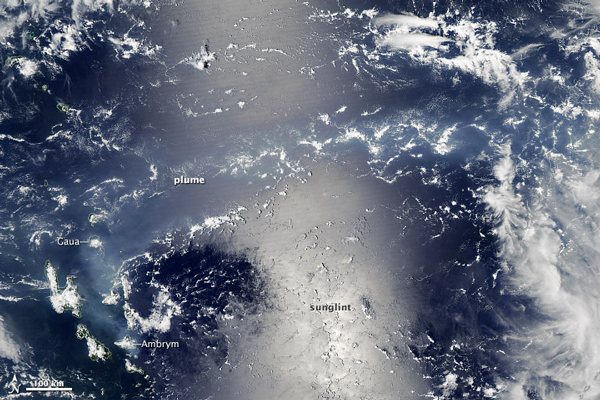
Crédit photo: NASA