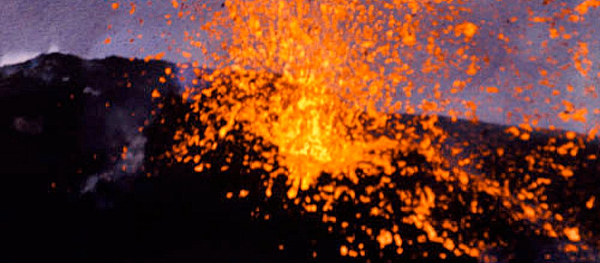
Islande : l’heure des pronostics ! // Iceland : time for predictions !

Les scientifiques islandais du Met Office et de l’Université d’Islande adorent faire des pronostics et des prévisions éruptives. Lorsque l’activité a commencé sur le Fagradalsfjall en 2021, ils ont affirmé que l’éruption était le début d’un nouveau cycle éruptif qui pourrait durer des mois, des années, voire plus. En fait, l’événement a duré six mois (19 mars – 18 septembre 2021). Une nouvelle éruption a débuté le 3 août 2022, et une autre, plus courte, a commencé le 10 juillet 2023 et s’est arrêtée le 5 août de cette même année.
Cette fois, en 2024, le Met Office est persuadé que l’éruption actuelle à Sundhnúkagígar marque probablement la fin d’une série dans la zone proche de Grindavík, même si elle est entrée dans sa troisième semaine et se poursuit au moment où j’écris ces lignes.
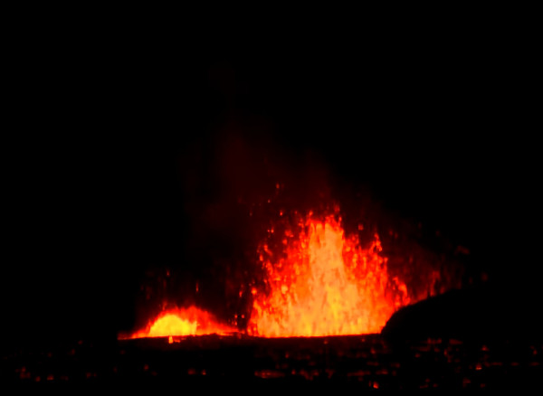
L’éruption a commencé le 16 mars 2024. L’activité reste confinée dans deux cratères, avec une émission de lave constante et aucun signe montrant que l’éruption est sur le point de se terminer. La majeure partie de l’activité se déroule dans le plus grand des deux cratères. Une certaine pollution par les gaz est parfois observée à Grindavík et Hafnir.
Selon un professeur de volcanologie de l’Université d’Islande, certains signes laissent supposer qu’il s’agit de la dernière éruption d’un cycle qui a débuté en décembre 2023. La chambre magmatique la moins profonde, située sous Svartsengi, n’est plus alimentée. Cela signifie que le magma en provenance de la chambre magmatique profonde monte directement vers vers la surface. L’éruption pourrait prendre fin dans les prochains jours.
Source  : Iceland Review.

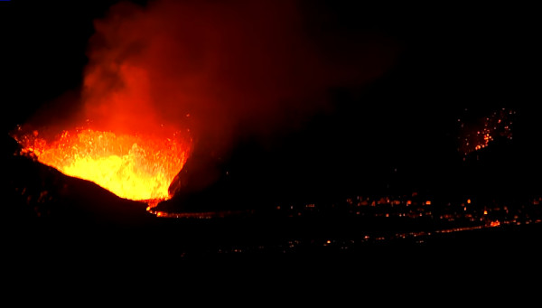
Image webcam de l’éruption le 1er avril 2024

—————————————————–

Icelandic scientists at the Met office and the University of Icelad love making predictions. When activity started at Fagradalsfjall in 2021, they said the eruption was the start of a new eruptive cycle which might last for months, years or even more. Actually the event lasted six months (19 March – 18 September, 2021). A new eruption started aon August 3rd, 2022, and another short one began on July 10th, 2023 and stopped on Augsu 5th. .

This time, in 2024, the Met Office is persuaded that the current eruption in Sundhnúkagígar could mark the end of a string of eruptions in the area near Grindavík, although it is in its third week and still continuing.

The eruption began on March 16th 2024.Activity remains in two craters in the area, with steady lava flow and no immediate signs of the eruption ending. Most of the activity is ongoing in the larger of the two craters. Some gas pollution is sometimes detected in Grindavík and Hafnir.

According to a professor of volcanology at the University of Iceland, there are signs that this might be the final eruption in the cycle of volcanic activity which began in December 2023. The shallower magma chamber in the area, situated under Svartsengi, is no longer receiving magma from the eruption. Therefore, magma from the deeper magma chamber in the area is flowing to the surface and the eruption might come to an end in the next few days.

Source : Iceland Review.

KMT, un projet ambitieux en Islande // KMT, an ambitious project in Iceland

Dans deux notes publiés le 28 septembre 2021 et le 22 janvier 2024, j’expliquais qu’un nouveau projet – Krafla Magma Testbed (KMT) – est en cours de développement en Islande.

https://claudegrandpeyvolcansetglaciers.com/2021/09/28/voyage-au-centre-de-la-terre-journey-to-the-centre-of-the-earth-3/

https://claudegrandpeyvolcansetglaciers.com/2024/01/22/islande-la-geothermie-au-coeur-dun-volcan-iceland-geothermy-at-the-heart-of-a-volcano/

Un article publié le 23 mars 2024 sur le site Iceland Monitor nous informe que deux des principaux objectifs du projet sont « d’améliorer considérablement les prévisions des éruptions volcaniques dans le monde et de concevoir de nouvelles méthodes plus économiques pour la production d’énergie géothermique. »
La société KMT vise à construire dans les années à venir un centre de recherche international de recherche en matière de volcanisme et d’énergie dans la région du Krafla à Þingeyjarsveit. L’idée du projet est née du forage IDDP-1 qui, en 2009, a atteint de manière tout à fait inattendue une poche de magma dans la région du Krafla, à une profondeur de 2,1 km.
L’équipement utilisé en 2009 n’était pas capable de résister à la chaleur, à la pression et à la corrosion à proximité du magma, mais des informations importantes ont été recueillies au niveau du forage avant sa fermeture. Les scientifiques ont pu déterminer l’emplacement exact d’une chambre magmatique, une première mondiale, et le forage s’est avéré dix fois plus puissant que les forages traditionnels déjà réalisés dans la région du Krafla.
Quinze ans après le forage de 2009, l’objectif est de récidiver avec une nouvelle technologie mise au point par la société KMT.
Voici une vidéo de KMT (en anglais) expliquant le projet et ses ambitions :
https://youtu.be/Bf-yA_L8mZA

Photos: C. Grandpey

————————————————-

In two posts released on September 28th, 2021 and January 22nd, 2024, I explained that a new project – Krafla Magma Testbed (KMT) – is being developed in Iceland.

https://claudegrandpeyvolcansetglaciers.com/2021/09/28/voyage-au-centre-de-la-terre-journey-to-the-centre-of-the-earth-3/

https://claudegrandpeyvolcansetglaciers.com/2024/01/22/islande-la-geothermie-au-coeur-dun-volcan-iceland-geothermy-at-the-heart-of-a-volcano/

An article published on March 23rd, 2024 on the website Iceland Monitor informs us that two of the main goals of the project are « to greatly improve global volcanic eruption predictions and design new and more cost-effective methods for the energy production of geothermal energy. »

KMT aims to build an international research center for volcanic and energy research in the Krafla area in Þingeyjarsveit in the coming years. The idea for the project stems from the Icelandic deep-water drilling project IDDP-1, where they unexpectedly drilled into magma at Krafla at a depth of 2.1 km in 2009.

The equipment used in IDDP-1 in 2009 was not able to withstand the heat, pressure, and corrosion closer to the magma but important information was gathered from the borehole before it was closed. Scientists were now able to determine the exact location of a base magma chamber, which is considered unique worldwide, and the borehole was found to be ten times more powerful than traditional production boreholes in Krafla.

Now fifteen years after the unexpected drilling of magma in Krafla, the aim is to do so again with a new instrumentation that KMT is developing.

Here is a video from KMT explaining the project and its ambitions:

https://youtu.be/Bf-yA_L8mZA

Islande : suite de l’éruption et essaim sismique sur l’Askja // Iceland : the eruption continues ; seismic swarm at Askja

Alors que l’éruption se poursuit de manière assez stable sur la péninsule de Reykjanes, bien qu’en lent et régulier déclin de jour en jour, le Met Office indique que le 25 mars 2024 un essaim sismique comprenant une trentaine d’événements a été enregistré dans la partie nord-ouest de la caldeira de l’Askja.

Sur la Péninsule de Reykjanes, les mesures GPS de ces derniers jours montrent un soulèvement continu du sol dans le secteur de Svartsengi, mais à un rythme plus lent qu’auparavant. Cela laisse supposer que le magma continue de s’accumuler dans le réservoir malgré son évacuation par l’éruption en cours.

Image webcam de l’éruption sur la péninsule de Reykjanes au cours de l’après-midi du 26 mars 2024

Le séisme le plus significatif sur l’Askja avait une magnitude de M3,5 à une profondeur d’environ 5 km. Dans l’ensemble, l’activité sismique sur l’Askja est restée assez stable d’un mois à l’autre et inchangée jusqu’au 25 mars 2024. Auparavant, des séismes d’une magnitude supérieure à M3 avaient été détectés en janvier 2022 et octobre 2021.
La déformation sur l’Askja s’est poursuivie de manière stable pendant deux ans à partir de la fin de l’été 2021. À l’automne 2023, une accélération de la déformation du sol a été enregistré par les instruments. Les mesures les plus récentes montrent que la déformation du sol a de nouveau augmenté, même si elle reste à un niveau inférieur à celui d’avant l’automne 2023.
Une image satellite acquise le 19 mars 2024 montre une vue classique du lac de l’Askja (Oskjuvatn) pendant l’hiver, avec la majeure partie du lac recouverte de glace à l’exception des deux zones bien connues où se produit une activité géothermique permanente.
Source : Met Office islandais.

Caldeira de l’Askja en été (Photo: C. Grandpey)

——————————————–

While the eruption is going on in a fairly stable way on the Reykjanes Peninsula, although slowly declining day after day, the Met Office indicates that on March 25th, 2024 a seismic swarm including about 30 events occurred in the NW part of the Askja caldera.

On the Reykjanes Peninsule, GPS measurements in recent days indicate ongoing land rise in Svartsengi, but it exhibits a slower rate than before. This suggests that magma continues to accumulate in the reservoir despite the ongoing eruption.

The largest earthquake recorded in the Askja area had a magnitude M3,5 at a depth of about 5 km. Overall, seismic activity in the Askja had been quite stable between months and unchanged until March 25th. Looking back, earthquakes with magnitude above M3 were detected in January 2022 and October 2021.

Deformation at Askja continued in a stable way during two years starting at the end of summer 2021. In autumn 2023, a change in velocity was recorded bt the instruments. However, the most recent ground deformation measurements suggest that the rate has increased again, even though it remains at lower rates than before autumn 2023.

A satellite image acquired on March 19th, 2024 shows a typical winter view of Askja lake, where most of the lake is covered by ice except for the two well-known areas characterized by persistent geothermal activity.

Source : Icelandic Met Office.

Péninsule de Reykjanes (Islande) : nouvelles de l’éruption // Reykjanes Peninsula (Iceland) : news of the eruption

Les webcams montrent que l’activité au niveau de la fissure éruptive de Sundhnúksgíga, sur la péninsule de Reykjanes, diminue lentement et régulièrement depuis le 22 mars 2024, ce qui est confirmé par le tremor éruptif. La lave jaillit désormais principalement des deux plus grandes bouches éruptives, et avec moins de vigueur qu’auparavant.
La coulée de lave qui se dirigeait vers la Grindavíkurvegur semble s’être arrêtée après être entrée dans la carrière de gravier de Melhólsnáma. Le Met Office indique qu’il n’y a pas non plus d’activité en bordure de la Suðurstrandarvégur. L’éruption dure depuis 9 jours.
Source : Met Office.

Image webcam du 24 mars 2024 au soir

——————————————

The webcams show that activity at the eruptive fissure at Sundhnúksgíga on the Reykjanes Peninsula has been slowly declining since March 22nd, 2024, which is confirmed by the eruptive tremor. Lava now mainly erupts from the two largest craters, and with less force than before.
The lava tongue that was heading towards the Grindavíkurvegur road seems to have stopped after it went into the Melhólsnáma gravel mine. The Met Office indicates that there is no activity on the edge of the Suðurstrandarvégur road either. The eruption has been going on for 9 days today.

Source : Met Office.