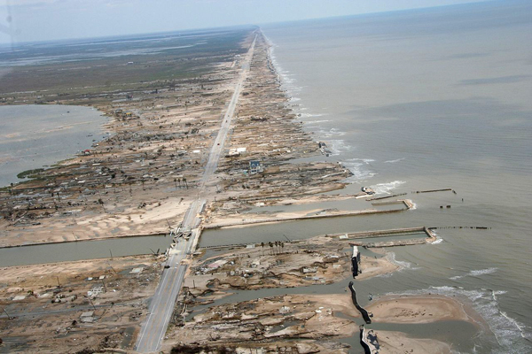
Plusieurs puissants séismes ont secoué l’île indonésienne de Lombok au cours des dernières semaines. Un premier séisme d’une magnitude de M,6,4 a été enregistré le 29 juillet 2018 ; il a tué 13 personnes et en a blessé une centaine d’autres. Le séisme suivant – M 6,9 sur l’échelle de Richter le 5 août 2018 – a fait au moins 98 morts et des centaines de blessés. Des milliers de bâtiments ont été endommagés et les opérations de secours ont été compliquées par des pannes de courant, un manque de réception téléphonique dans certaines zones et des options d’évacuation limitées.
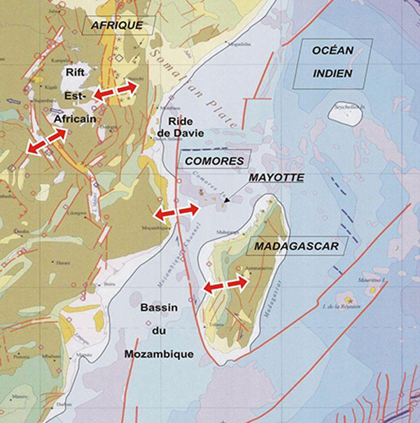
Les séismes sont fréquents en Indonésie car le pays est situé sur la Ceinture de Feu du Pacifique, bien connue pour son activité sismique et volcanique. La majorité des grands séismes se produisent sur ou près des limites entre les plaques tectoniques qui composent la surface de la Terre, et les exemples récents ne font pas exception. Cependant, il existe des conditions tectoniques particulières autour de l’île de Lombok.
Les derniers séismes ont été observés le long d’une zone assez spéciale où la plaque tectonique australienne commence à passer par-dessus la plaque où se trouve l’île de Lombok. Elle ne glisse pas en dessous de sa voisine – processus de subduction très fréquent – comme cela se produit plus au sud de Lombok. (voir carte ci-dessous)
Certains des séismes qui secouent l’Indonésie peuvent être très violents, comme le séisme de M 9,1 sur la côte ouest de Sumatra qui a déclenché le tsunami de 2004 dans l’Océan Indien. Ce séisme s’est produit le long de la zone de subduction Java-Sumatra, là où la plaque australienne plonge sous la plaque de la Sonde.
À l’est de Java, la zone de subduction se trouve « bloquée » par la croûte continentale australienne, beaucoup plus épaisse que la croûte océanique qui glisse sous Java et Sumatra. Comme la croûte continentale australienne ne parvient pas à passer sous la plaque de la Sonde, elle lui passe par-dessus. Ce processus est connu sous le nom de poussée d’arrière-arc.
Les données des récents séismes de Lombok suggèrent qu’ils sont liés à cette zone d’arrière-arc qui s’étend au nord des îles s’étendant de l’est de Java à l’île de Wetar, juste au nord du Timor. Historiquement, de puissants séismes se sont également produits le long de cette poussée d’arrière-arc près de Lombok, en particulier au 19ème siècle, mais aussi plus récemment.
Les épicentres des derniers tremblements de terre à Lombok ont été localisés dans le nord de l’île, sous terre, et à faible profondeur. Les séismes terrestres peuvent parfois provoquer des glissements de terrain sous-marins et un tsunami. Lorsque des séismes peu profonds rompent le plancher océanique, ils peuvent déclencher des tsunamis meurtriers.
La région autour de Lombok a une histoire de tsunamis. En 1992, un séisme de magnitude 7,9 s’est produit au nord de l’île de Flores ; il a provoqué un tsunami qui a englouti plus de 2 000 villages côtiers. Les séismes du 19ème siècle dans cette région ont également causé de puissants tsunamis qui ont tué de nombreuses personnes.
Malheureusement, on ne sait pas prévoir les séismes. Une compréhension des dangers et une éducation des populations sont donc essentielles pour se préparer aux événements futurs.
Source: The Conversation, USGS.
Le bilan du dernier séisme est de 131 morts (164 selon les dernières chiffres de la presse indonésienne), 1477 blessés et 156 000 personnes déplacées.
————————————————-
 Several large earthquakes have struck the Indonesian island of Lombok in the past weeks. A first quake with a magnitude of M 6.4 was recorded on July 29th, 2018, killing13 people and injuring a hundred more. The largest event – M 6.9 on the Richter scale on August 5th, 2018 – killed at least 98 people and injured hundreds. Thousands of buildings were damaged and rescue efforts were hampered by power outages, a lack of phone reception in some areas and limited evacuation options.
Earthquakes are frequent in Indonesia as the country is located on the Pacific Ring of Fire, well known for its seismic and volcanic activity. The majority of large earthquakes occur on or near Earth’s tectonic plate boundaries, and the recent examples are no exception. However, there are some special tectonic conditions around Lombok.
The recent earthquakes have occurred along a specific zone where the Australian tectonic plate is starting to move over the Indonesian island plate; it does not slide underneath it, as occurs further to the south of Lombok. (see map below)
Some of the earthquakes that shake Indonesia can be very powerful, such as the M 9.1 quake off the west coast of Sumatra that generated the 2004 Indian Ocean tsunami. This earthquake occurred along the Java-Sumatra subduction zone, where the Australian tectonic plate plunges underneath Indonesia’s Sunda plate.
To the east of Java, the subduction zone has become “jammed” by the Australian continental crust, which is much thicker than the oceanic crust that moves beneath Java and Sumatra. The Australian continental crust can’t be pushed under the Sunda plate, so instead it is starting to ride over the top of it. This process is known as back-arc thrusting.
The data from the recent Lombok earthquakes suggest they are associated with this back-arc zone which extends north of islands stretching from eastern Java to the island of Wetar, just north of Timor. Historically, large earthquakes have also occurred along this back-arc thrust near Lombok, particularly in the 19th century but also more recently.
Lombok’s recent earthquakes occurred in northern Lombok under land, and were quite shallow. Earthquakes on land can sometimes cause undersea landslides and generate a tsunami wave. But when shallow earthquakes rupture the sea floor, much larger and more dangerous tsunamis can occur.
The region around Lombok has a history of tsunamis. In 1992, an M 7.9 earthquake occurred just north of the island of Flores and generated a tsunami that swept away coastal villages, killing more than 2,000. 19th century earthquakes in this region also caused large tsunamis that killed many people.
Unfortunately, earthquakes cannot be predicted, so an understanding of the hazards and an education of the populations are vital to be prepared for future events.
Source: The Conversation, USGS.
According to the latest figures, 131 persons were killed (164 according to the latest figures in the Indonesian newspapers), 1477 injured and 156,000 displaced by the last earthquake.

Source: The Conversation