Yellowstone (Etats Unis): Aucun risque d’éruption à court terme ! // No risk of a short-term eruption !

drapeau-francaisIl y a quelques jours (le 6 mai 2016), le tabloïd britannique Daily Express a publié un de ces articles dont le seul but est d’attirer plus de lecteurs, mais qui n’ont aucune valeur scientifique
On pouvait lire qu’ « après la série de séismes enregistrés à travers le monde, il y a de plus en plus de craintes que le volcan du Wyoming (autrement dit Yellowstone) soit sur le point d’entrer en éruption, ce qui pourrait rendre les deux tiers des Etats-Unis immédiatement inhabitables car les volumineuses émissions de cendre dans l’atmosphère bloqueraient la lumière du soleil et affecteraient directement la vie sous ce nuage de cendre. Les chasseurs d’OVNI ont mis de l’huile sur le feu en prétendant avoir vu un vaisseau spatial extraterrestre en train de planer au-dessus du volcan de Yellowstone, dans le but de le surveiller avant une puissante éruption à très court terme. »
Heureusement, cette information est totalement infondée et le dernier rapport de l’Observatoire Volcanique de Yellowstone pour le mois d’avril est loin d’être alarmant. Voici les principaux éléments du rapport:
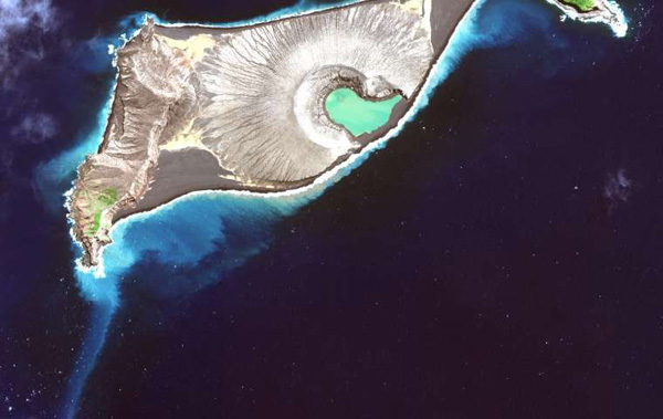
Au cours du mois d’avril 2016, 53 séismes ont été détectés dans le parc national de Yellowstone. L’événement le plus significatif était un micro séisme de magnitude M 2.0 le 23 avril, à 6,5 km au nord du Norris Geyser Basin. En avril 2016, la sismicité a inclus un petit essaim de 11 événements le 17 avril. La secousse la plus forte, d’une magnitude de M 1,5, a eu lieu le 17 avril à 13 km à l’est de West Thumb.
En ce qui concerne la déformation du sol, un petit soulèvement du sol (environ 1 cm) a été enregistré dans la partie nord de la caldeira de Yellowstone. L’inflation semble avoir commencé au début de l’année 2016 et son évolution est semblable à  ce qui avait été observé en 2013-2014. La plupart des stations GPS à l’intérieur de la caldeira enregistrent un léger affaissement, à raison d’environ 1,5 cm par an. Globalement, la déformation actuelle à Yellowstone reste dans la norme historique.

———————————–

drapeau-anglaisA few days ago (on May 6th 2016), the British Daily Express released one of these articles whose only goal is to attract more readers and which are a nonsense from a scientific point of view

One could read that “following a spate of seismic activity around the globe, fears have been mounting the volcano in Wyoming (i.e.Yellowstone) could be about to blow which could leave two-thirds of the USA immediately uninhabitable as the large spew of ash into the atmosphere would block out sunlight and directly affecting life beneath it. UFO hunters have now added more fuel to the fire by claiming to have spotted alien spacecraft hovering over the Yellowstone volcano, claiming they are monitoring it before its imminent massive eruption.”

Fortunately, this piece of news is totally unfounded and the Yellowstone Volcano Observatory’s latest report for the month of April is by no means alarming. Here are the main parts of the report:

During April 2016, 53 earthquakes were located in the Yellowstone National Park. The largest event was a micro earthquake of magnitude M 2.0 on April 23rd and was located 6.5 km north of Norris Geyser Basin.  April 2016 seismicity included a small earthquake swarm of 11 earthquakes occurring on April 17th. The largest event, with a magnitude of M 1.5, occurred on April 17th 13 km east of West Thumb.
As far as ground deformation is concerned, a small amount of ground uplift (about 1 cm) has been recorded to the north of the Yellowstone Caldera. The uplift appears to have started early in 2016 and the apparent pattern is similar to that observed in 2013/2014. Most of the GPS stations within the caldera record slight subsidence, at a rate of about 1.5 cm/year. Current deformation patterns at Yellowstone remain within historical norms.

Norris-Geyser-Basin

West Thumb blog

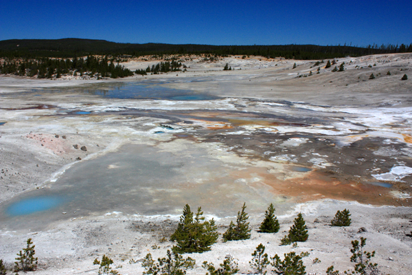
Vue des champs hydrothermaux de Norris et West Thumb.

(Photos: C. Grandpey

La tomographie muonique appliquée à la Soufrière de la Guadeloupe // Muon tomography at the Soufriere volcano (Guadeloupe)

drapeau francaisJ’ai écrit entre 2007 et 2016 plusieurs articles à propos de l’utilisation des muons dans le domaine volcanique. Ces particules cosmiques devraient permettre aux scientifiques de faire des progrès considérable dans la compréhension de la structure interne d’un volcan. Je vous invite à relire ma note du 10 février 2016 pour obtenir des explications sur cette technologie.

La tomographie muonique n’est pas très récente ; c’est sa mise en place sur le terrain qui pose le plus de problèmes. Elle a été utilisée par les Japonais pour visualiser la structure interne de volcans comme l’Asama, l’Iwate ou encore le volcan Satsuma-Iojima dans la préfecture de Kagoshima. Les scientifiques savaient que ce volcan dissimulait un réservoir magmatique, mais la tomographie muonique a révélé que la quantité de magma était beaucoup plus grande que prévu.

Les scientifiques français ont eux aussi utilisé la tomographie muonique dans le cadre du projet DIAPHANE sur le volcan de la Soufrière à la Guadeloupe. Des équipes du CNRS ont installé des capteurs de muons cosmiques sur les flancs du volcan. La technologie a permis de «suspecter la présence d’importantes cavités» à l’intérieur de l’édifice volcanique.

En cliquant sur le lien ci-dessous, vous pourrez visionner un excellent document montrant la mise en place du projet DIAPHANE (IPNL / Géosciences Rennes / IPGP / ANR Diaphane 2014-2018) sur la Soufrière en avril-mai 2015. Il a fait suite à plusieurs mois de préparation, construction, tests et calibrations des détecteurs à muons employés sur le terrain, avec l’appui et l’expertise des services techniques de l’Institut de Physique Nucléaire de Lyon (IPNL), bureau d’études, mécanique, chaudronnerie, informatique et électronique.

Lors de la mission d’installation, quatre nouveaux détecteurs ont été déployés autour du volcan, en des endroits dont l’accès n’était pas toujours facile et nécessitait l’intervention de spécialistes.

Le but du projet est d’augmenter la couverture tomographique du dôme du volcan, conformément au planning de l’Agence Nationale de la Recherche (ANR) Diaphane, accepté en juillet 2014. Il s’agit aussi de fournir des données uniques, non seulement d’imagerie structurelle, mais surtout du suivi dynamique du système hydrothermal du volcan. Le rapport entre le niveau d’eau liquide et gazeuse est en effet un des points essentiels dans la compréhension du fonctionnement d’un volcan de ce type, constamment arrosé par les pluies tropicales (8 à 10 mètres de précipitations annuelles !), et siège de fréquentes éruptions phréatiques.

Les détecteurs à muons sont aujourd’hui en opération permanente et produisent des données reçues et traitées à l’IPNL.
https://vimeo.com/139232294

———————————–

drapeau-anglaisI wrote between 2007 and 2016 several articles about the use of muons in volcanology. These cosmic particles should allow scientists to make considerable progress in understanding the internal structure of a volcano. I invite you to reread my note of 10 February 2016 for an explanation of the technology.
Muon tomography is not very recent; it is its implementation on the ground that poses the most problems. It was used by the Japanese to visualize the internal structure of volcanoes like Mt Asama, Mt Iwate or Mt Satsuma-Iojima in Kagoshima Prefecture. Scientists knew that the volcano concealed a magma chamber, but muon tomography revealed that the amount of magma was much larger than expected.
French scientists have also used muon tomography in the DIAPHANE project on the Soufriere volcano in Guadeloupe. CNRS teams have installed  cosmic muon sensors on the flanks of the volcano. The technology has « suspect the presence of large cavities » within the volcanic edifice.
By clicking on the link below, you can watch an excellent document showing the implementation of the DIAPHANE project (IPNL / Geosciences Rennes / IPGP / ANR Diaphane 2014-2018) on the Soufriere in April-May 2015. It followed several months of preparation, construction, testing and calibration of the muon detectors tob used on the field, with the support and expertise of the technical services of the Institute of Nuclear Physics of Lyon (IPNL), engineering, mechanics, computers and electronics.
During the installation mission, four new detectors were deployed around the volcano, in places whose access was not always easy and required the intervention of specialists.
The goal of the project is to increase the tomographic coverage of the dome of the volcano, according to the schedule of the National Research Agency (ANR), agreed in July 2014. The project is also expected to provide unique data not only about the structural imaging, but also about the dynamic monitoring of the hydrothermal system of the volcano. The relationship between the level of liquid and gaseous water is indeed a key point in understanding a volcano like this, constantly watered by tropical rains (8 to 10 meters of annual rainfall!) and the seat frequent phreatic eruptions.
The muon detectors are now in permanent operation and produce data received and processed by IPNL.
https://vimeo.com/139232294

Voici l’image obtenue pour la Soufrière de La Guadeloupe :

Muons Soufrière

Source: CNRS.

Cartographie de Hunga Ha’apai (Iles Tonga) // Mapping of Hunga Ha’apai (Tonga Islands)

drapeau-francaisEn janvier 2015 (voir mes notes), une nouvelle île est brusquement apparue à la surface de l’Océan Pacifique dans l’archipel des Tonga. Au cours du printemps 2016, les scientifiques ont élaboré une carte détaillée de sa topographie.
La nouvelle île, officieusement baptisée «  Hunga Tonga Hunga Ha’apai »,.s’est formée au cours d’une éruption « surtseyenne », avec montée de magma depuis les fonds marins et rencontre avec les eaux froides de l’océan, ce qui a donné naissance à de spectaculaires gerbes cypressoïdes, bien connues dans un tel contexte.

Le navire de recherche Falkor du Schmidt Ocean Institute a permis de réaliser la cartographie de la nouvelle île en collaboration avec la NASA au cours d’une mission dont l’objectif était en fait d’étudier la vie marine dans les zones hydrothermales du Bassin de Lau (voir carte ci-dessous).
Comme une grande partie de la dynamique des paysages associés aux nouveaux volcans insulaires océaniques se produit sous l’eau, ce projet fournira aux scientifiques une vue en trois dimensions de la nouvelle île, depuis les fonds marins jusqu’à son sommet qui se dresse à environ 130 mètres au-dessus du niveau de la mer.
La cartographie permettra aux chercheurs de mieux comprendre comment évoluent ces îles à la formation rapide et pourquoi leur espérance de vie est souvent limitée. Une analyse préliminaire par les scientifiques de la NASA montre pourquoi la nouvelle île a perdu près de 30 pour cent de sa superficie initiale en seulement 15 mois, depuis l’arrêt de l’activité éruptive fin janvier 2015. Les travaux ont montré que la topographie sous-marine autour de la nouvelle île affecte la vitesse et l’emplacement de l’érosion qui est due principalement à l’abrasion marine et à l’affaissement de l’édifice.
Le travail contribuera également à la compréhension des processus hydro-volcaniques sur des planètes telles que Mars où les structures volcaniques de morphologie semblable ont été observées par les satellites de la NASA.
Source: Phys.org: http://phys.org/

————————————–

drapeau-anglaisIn January 2015 (see my notes), a new island exploded into view from the bottom of the Pacific Ocean and scientists this spring have created a detailed map of its topography.

The new island—unofficially named Hunga Tonga Hunga Ha’apai—was formed in a « surtseyan » eruption, with hot magma rising from the seafloor into cool water, which causes cypress tree-like steam and magma emissions.

The Schmidt Ocean Institute’s research vessel Falkor conducted the mapping in collaboration with NASA during a research cruise whose focus was actually to explore marine life around the hydrothermal vent fields of the nearby eastern Lau Basin (see map below).

Because much of the landscape dynamics associated with new oceanic island volcanoes happens underwater, this project provides scientists with a view of the three dimensional character of the new island, from the seafloor to its approximately 130-metre-tall summit above sea-level.

The mapping will help researchers understand how such rapidly formed volcanic islands evolve and why their survival as land is often limited. Preliminary analysis by NASA scientists show why the new island has lost nearly 30 percent of its initial land area in only 15 months since the eruptive activity ended in late January 2015. The work showed that the submarine topography around the new island clearly affects the pace and location of erosion due primarily to marine abrasion and local subsidence.

The work will contribute to understanding of hydro-volcanic processes on planets such as Mars, where similar-appearing volcanic structures have been observed by NASA satellites.

Source: Phys.org: http://phys.org/

 Tonga-blog

Archipel des Tonga.

Tonga Kermadec Arc

Vue de l’arc Tonga-Kermadec.

Tonga ile

Hunga Ha’apai vue depuis l’espace (Crédit photo: NASA)

Images de Stromboli (Sicile / Italie)

drapeau-francaisEn cliquant sur le lien ci-dessous, vous pourrez voir une petite vidéo réalisée par l’ami Jean-Paul Céceille (adhérent de L’Association Volcanologique Européenne). Elle montre l’activité du Stromboli le 30 avril 2016. Elle était essentiellement concentrée dans la bouche située au sud-ouest (côté Ginostra). Le document propose également quelques images de Lipari et Vulcano.

https://www.youtube.com/watch?v=azgRu07uD4E

————————————–

drapeau-anglaisBy clicking on the link below, you will see a short video shot by my friend Jean-Paul Céceille (Member of L’Association Volcanologique Européenne). It shows activity at Stromboli volcano on April 30th 2016. It was mainly concentrated in the vent located to the SW of the crater. The document also invites you to a few minutes in Lipari and Vulcano.

https://www.youtube.com/watch?v=azgRu07uD4E

Strombo-blog

Photo: C. Grandpey