Faut-il construire des barrières de protection sur la péninsule de Reykjanes? // Should they build protective barriers on the Reykjanes Peninsula?

Au cours d’une nouvelle réunion publique qui s’est tenue à Grindavik le 2 juin 2022, il a été proposé d’ériger des barrières de protection sur la péninsule de Reykjanes. Un géophysicien de la Protection Civile a toutefois exprimé son scepticisme car il sera difficile de déterminer leur bon emplacement en cas d’éruption.
Bien que le Met Office islandais ait indiqué qu’aucun soulèvement du sol ne s’était produit au cours des trois à quatre derniers jours dans la région de Svartsengi, le département de Protection Civile a décidé de maintenir la réunion publique à Grindavík.
Il a été rappelé au public qu’à la fin mai, le sol autour de la centrale de Svartsengi s’était soulevé de près de cinq centimètres, probablement en raison d’une intrusion magmatique à 4-5 km sous la surface, et qu’un essaim sismique était toujours en cours, sans le moindre signe d’activité volcanique. Ces événements rappellent ce qui s’est passé dans la région avant l’éruption de Fagradalsfjall en 2021. Bien que l’éruption de Fagradalsfjall n’ait pas menacé les infrastructures dans la région, l’intrusion magmatique actuelle est différente car elle se situe au niveau de la centrale géothermique.
Outre des professeurs de géologie, la réunion publique de Grindavík a rassemblédes policiers et des services de secours de la péninsule de Reykjanes, ainsi que des représentants du département de la Protection Civile des localités voisines. Etaient également présents des représentants d’entreprises qui possèdent d’importants infrastructures dans la région.
Les quelques ingénieurs présents ont présenté les propositions d’un groupe de travail, créé en mars 2021 et chargé de protéger les importantes infrastructures en cas d’éruption.
Bien que les propositions du groupe de travail ne soient pas mises à la disposition des médias avant d’être examinées par les administrateurs publics, on sait d’ores et déjà que le groupe a proposé l’érection de barrières de protection contre la lave. Cependant, la proposition est sujette à un examen plus approfondi pour examiner son impact sur l’environnement, et déterminer le type de barrières (d’un seul tenant ou en plusieurs parties).
Selon un géophysicien du département de la Protection Civile, « étant donné que l’on a affaire à une zone ouverte avec de longues fissures, il est difficile de prévoir si une barrière de protection érigée avant une éruption sera implantée du bon côté de l’éruption… ou du mauvais côté. »
Même s’il n’y a actuellement aucun signe d’activité volcanique, un professeur de géologie et de volcanologie à l’Université d’Islande a déclaré que le calme relatif sur la péninsule au cours des derniers jours devait être considéré comme une « pause temporaire » ; cela ne veut pas dire que l’activité géologique a cessé. . Il a ajouté : « De toute évidence, l’intrusion magmatique n’a pas eu lieu à la profondeur précédente, et il n’y a donc pas de soulèvement, ce qui signifie que la menace immédiate d’une éruption a diminué ; il n’y aura pas d’éruption à brève échéance », Lorsqu’un journaliste lui a demandé : « Pas cet été ? », le professeur a répondu : »Je ne le pense pas. Je ne l’espère pas.

Comme je l’ai déjà écrit, il est facile de faire des prévisions lorsque la lave coule dans une zone désertique. La situation devient plus compliquée lorsque des zones habitées ou des infrastructures sont en jeu. Notre capacité à prévoir les éruptions devient alors très faible…
Source : Iceland Review.

———————————————–

Proposals to erect protective barriers on the Reykjanes peninsula were introduced at a new town hall meeting in Grindavík on June 2nd, 2022. A geophysicist with the Department of Civil Protection expressed scepticism that the barriers would be situated on the “right side” of a possible eruption.

Despite the Icelandic Met Office reporting that no uplift had occurred over the past three to four days in the Svartsengi area on the Reykjanes peninsula, the Department of Civil Protection held a town hall meeting in Grindavík.

The public was reminded that in late May the land around Svartsengi had risen almost five centimetres, likely owing to magma intrusion 4-5km below the surface, and an earthquake swarm had been ongoing, despite no signs of volcanic unrest. These geological events are reminiscent of similar disturbances in the area before the eruption near Fagradalsfjall in 2021. While the Fagradalsfjall eruption did not threaten infrastructure in the area, the current magma intrusion is located underneath a geothermal power plant.

In addition to professors in geology, the town hall meeting in Grindavík was also attended by police officers and search-and-rescue workers on the Reykjanes peninsula, along with representatives from the Department of Civil Protection from neighbouring municipalities, and from companies that operate important infrastructure in the area.

There were also a few engineers present who introduced the proposals of a task force, established in March of last year, entrusted with protecting important infrastructure in the event of an eruption.

Although the task force’s proposals will not be made available to the media prior to review by public administrators, it is known that, among other things, the task force had proposed the erection of preemptive protective barriers. However, the proposal is subject to further review, in regard to environmental impact, and in regard to just how complete these barriers will be.

According to aa geophysicist with the Department of Civil Protection, “given that we have an open area with long fissures, it’s uncertain whether a protective barrier that’s erected prior to an eruption will be situated on the right side of the eruption… or the wrong side.”

Despite no signs of volcanic unrest, a professor of geology and volcanology at the University of Iceland stated that the relative stillness on the peninsula over the past few days should be taken as a “temporary hiatus” as opposed to a sign that geological activity had ceased. He added : “Obviously, magma is no longer intruding at the former depth, and so there’s no uplift, which means that the immediate threat of an eruption has decreased; there won’t be an eruption any time soon,” When a reporter asked : “Not this summer?”, the professor answered :“I wouldn’t think so. I certainly don’t hope so.”

As I put it before, it is easy to make predictions when lava is flowing in a desert area. The situation becomes more serious when populated areas or infrastructure are at stake. Our ability to predict eruptions then becomes very low…

Source: Iceland Review.
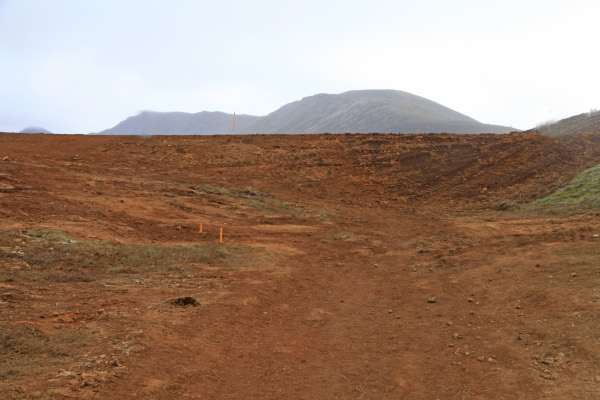
En 2021, des barrières de terre avaient été érigées pour protéger la route et un câble fibre optique (Photo: C. Grandpey)

La fonte des glaciers islandais (suite) // The melting of Icelandic glaciers (continued)

En cliquant sur le lien en bas de cette note, vous aurez accès à un document montrant la fonte des glaciers islandais à travers les âges. Les prises de vues et les photographies ont été compilées par une équipe de scientifiques de l’Université d’Islande. Elles montrent trois décennies de fonte glaciaire en un peu plus de trois minutes. Les chercheurs ont superposé des photos aériennes d’archives et des images récentes de drones pour montrer l’effet dramatique du réchauffement climatique sur les glaciers du sud-est de l’Islande. Certains de ces glaciers reculent à un rythme de 150 mètres par an. Depuis 2000, on estime que les glaciers islandais ont diminué d’environ 800 km2.
L’équipe scientifique était dirigée par Þorvarður Árnason, directeur du Centre de recherche Hornafjörður. Le scientifique a pris des photos du glacier Hoffellsjökull une fois par mois pendant huit ans.
L’Islande compte vingt glaciers émissaires qui partent de la calotte glaciaire du Vatnajökull. Tous ont reculé. Certains scientifiques affirment que si les conditions de réchauffement climatique se poursuivent au rythme actuel, les glaciers islandais risquent de disparaître complètement.
Þorvarður Árnason dit que nous devons expliquer la réalité à la population, sans toutefois l’effrayer. Nous devons faire prendre conscience de la gravité de la situation.
Après avoir documenté la situation actuelle, l’équipe scientifique se tourne maintenant vers l’avenir. Les chercheurs veulent prévisualiser à quoi ressemblera dans un siècle le Breiðamerkurjökull, le glacier islandais qui recule le plus rapidement, en prenant en compte les scénarios les plus optimistes et les plus pessimistes.

https://edition.cnn.com/videos/world/2022/05/04/iceland-glaciers-melting-over-time-c2e-intl-lon-orig.cnn

Source: Iceland Review, CNN.

—————————————–

By clicking on the link at the bottom of this post, you will have access to a document showing the melting of Icelandic glaciers through the ages. The footage and photography were compiled by a team of scientists at the University of Iceland. They show three decades of glacial melt in just over three minutes. The team superimposed archival aerial photos on top of contemporary drone footage to show the dramatic effect that warming climates have had on glaciers in Southeast Iceland. Some of these glaciers are retreating at a rate of 150 metres a year. Since 2000, it has been estimated that Iceland’s glaciers have decreased by some 800 km2.

The team of scientists was led by Þorvarður Árnason, director at the Hornafjörður Research Centre. The scientist started to do repeat photography at Hoffellsjökull, and did it once a month for eight years.

Iceland has twenty outlet glaciers that extend from the Vatnajökull ice cap. All of them have receded. Some experts say that if global warming conditions continue at the current pace, Iceland’s glaciers are at risk of disappearing completely.

Þorvarður Árnason says that we need to tell people what the reality is without frightening them; however, we should make them aware how serious the situation is.

Having documented the present situation, the scientific team is now turning their attention toward the future. They want to pre-visualize what Iceland’s fastest retreating glacier, Breiðamerkurjökull, will look like 100 years from now, taking into account both worst case and best case scenarios.

https://edition.cnn.com/videos/world/2022/05/04/iceland-glaciers-melting-over-time-c2e-intl-lon-orig.cnn

Source: Iceland Review, CNN.

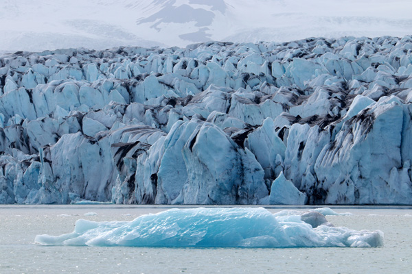
Front du Solheimajökull et du Vatnajökull  (Photos: C. Grandpey)

La foule en Islande cet été // Crowds in Iceland this summer

Si vous aviez l’intention de vous rendre en Islande pendant les vacances d’été, il est peut-être déjà trop tard. Les autorités islandaises préviennent qu’il y aura beaucoup de monde dans leur pays pendant l’été 2022 et qu’il devient déjà difficile de trouver un logement dans certaines régions. Trouver une voiture de location est également problématique. Le gérant d’une agence de voyages a déclaré : « Nous sommes presque à la capacité maximale pour juin, juillet et août dans de nombreuses régions, avec une pénurie de voitures de location durant ces mois. » La plupart des régions sont entièrement réservées pour la haute saison. Il sera difficile de trouver des chambres d’hôtel en juillet et en août partout dans le pays. Bien sûr, on peut se rabattre sur le camping qui est très agréable en Islande… à condition qu’il ne pleuve pas. On peut aussi prendre un bus pour se déplacer.
Selon les autorités islandaises, les gens sortent de leurs cocons après la crise de Covid et le tourisme reprend en conséquence. De nombreux touristes d’Europe du Nord seront en Islande cet été et il semble qu’ils resteront plus longtemps.
J’ai séjourné en Islande au début du mois de juillet 2021 et il y avait très peu de touristes. Mon côté ours me fait fuir les foules. J’irai donc visiter des endroits plus calmes cet été, mais plutôt en septembre quand les gens auront repris le travail !

Un séjour en Islande serait encore meilleur si une éruption se produisait. Personne ne sait prédire l’avenir volcanique mais il semble peu probable qu’un tel événement se produise dans les prochaines semaines. Certes, on, observe des pics de sismicité et des épisodes d’inflation sur la péninsule de Reykjanes, mais rien de vraiment significatif pour le moment.

NB: Suite à cette note sur la présence d’un très grand nombre de touristes en Islande au cours des prochains mois, un visiteur de mon blog me signale qu’il n’y a plus de places d’avion disponibles avant le mois de septembre au minimum. .

—————————————

If you intended to to to Iceland during the summer holidays, it might be too late. Icelandic tourist authorities warn that the summer of 2022 will be busy in the country and it is already getting difficult to get accomodation in some areas as well as rental cars. Said the manager of a travel agency : « We are almost to the maximum capacity for June, July and August in many areas, with a shortage of rental cars during these months. » Most areas are fully booked for the high season. It can be difficult to get hotel rooms in July and August everywhere in the country. Of course, you can go camping, which is very pleasent in Iceland….provided it does not rain, and take a bus to move around.

Icelandic authorities say it looks like people are coming out of their cocoons after Covid and tourism is picking up as a result. A lot of tourists from Northern-Europe will be in Iceland this summer and it seems they will be staying longer.

I spent some time in Iceland in July 2021 with very few tourists around. My bear spirit keeps me away from the crowds, so I will go and visit some quieter palces this summer, but rather in September when people have gone back to work!

A stay in Iceland would be even better if an eruption occurred. Nobody can predict the volcanic future but it seems unlikely that such an event will occur in the coming weeks. Sure, there are sometimes peaks of seismicity and episodes of inflation on the Reykjanes peninsula, but nothing really significant for the moment.

Editor’s note : Following this post about the very large number of tourists in Iceland over the next few months, a visitor to my blog told me that there are no more plane seats available until at least September.

Photos: C. Grandpey

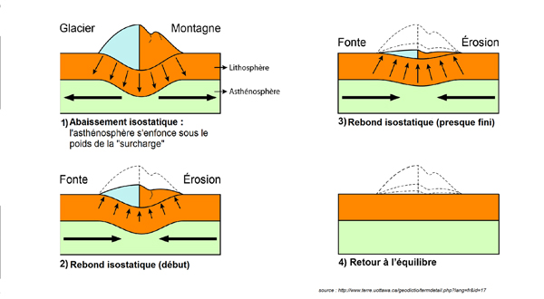
Rebond isostatique et baisse du niveau de la mer // Isostatic rebound and sea level drop

Un article paru dans le quotidien Ouest France en avril 2002 se demande pourquoi le niveau de la mer baisse en Islande, alors qu’il est en hausse partout dans le monde. En fait, la réalité est un peu différente. Comme je l’explique au cours de ma conférence « Glaciers en péril », ce n’est pas vraiment le niveau de la mer qui baisse en Islande, mais la terre qui se soulève. Les scientifiques prennent souvent l’exemple du petit port d’Höfn sur la côte sud de l’île pour illustrer ce phénomène.

Dans l’article diffusé par le quotidien, une climatologue à l’Institut de Recherche pour le Développement (IRD) explique que le niveau moyen de la mer a augmenté d’une vingtaine de centimètres depuis le début du 20ème siècle, mais il s’agit d’un niveau moyen. Autrement dit, il y a des endroits où la hausse est plus importante qu’à d’autres, avec des variations de quelques centimètres. Par exemple, le niveau de l’eau augmente deux à trois fois plus vite qu’ailleurs dans l’océan Pacifique parce que les courants océaniques ne distribuent pas la chaleur de manière homogène. A contrario, il existe d’autres zones où aucune élévation du niveau de la mer n’est enregistrée et parfois même une légère baisse est constatée, comme en Islande. Le Groenland et d’autres pays, essentiellement dans l’Arctique, sont concernés. C’est aussi le cas de quelques zones proches du pôle Sud.

En fait, plus que d’une baisse du niveau de la mer, il s’agit d’une élévation de la terre. Il s’agit d’un phénomène appelé rebond post-glaciaire ou rebond isostatique qui a déjà été observé au cours de la dernière glaciation, il y a environ 20 000 ans. D’énormes calottes de glaces se sont alors formées au nord des États-Unis, du Canada ou encore de l’Europe. Sous leur poids, le sol s’est enfoncé dans les zones concernées. Au terme de cette période glaciaire – il y a entre 20 000 et 10 000 ans – le climat s’est réchauffé et a entraîné la fonte des calottes glaciaires qui ont pesé moins lourd sur le plancher océanique et terrestre. Sous cet effet, le sol s’est soulevé, et c’est ce qui se passe aujourd’hui en Islande où les glaciers fondent sous les coups de butoir du réchauffement climatique.

La climatologue de l’IRD ajoute que la baisse apparente du niveau de la mer en Islande s’explique aussi par la gravité. En effet, une grosse calotte glaciaire a tendance à attirer la mer, un peu comme l’attraction exercée par la Lune sur nos mers. En conséquence, si la calotte fond et disparaît petit à petit, elle attire moins la mer. Plus la calotte glaciaire disparaîtra, plus la surface de la mer sera basse. Cet effet est, lui aussi, assez local.

Les scientifiques ne pensent pas que la baisse du niveau de la mer en Islande va se poursuivre. Elle sera compensée, puis dépassée, par l’élévation globale du niveau des océans dans le monde. Les projections d’ici la fin du siècle prévoient une hausse du niveau de la mer importante, si bien qu’en 2100, les conséquences du rebond isostatique existeront toujours mais seront globalement compensés par la dilatation thermique de l’océan et l’apport d’eau douce à la mer par la fonte des glaciers continentaux et des calottes polaires.

Source: Ouest France.

——————————————–

An article published in the French daily Ouest France in April 2002 asks why the sea level is dropping in Iceland, while it is rising all over the world. In fact, the reality is a little different. As I explain during my conference « Glaciers at Risk », the sea level is not really decreasing in Iceland, but the land is rising. Scientists often take the example of the small port of Höfn on the south coast of the island to illustrate the phenomenon.
In the article published by the daily, a climatologist at the Research Institute for Development (IRD) explains that the average sea level has risen by about twenty centimeters since the beginning of the 20th century, but it is an average number. In other words, there are places where the rise is greater than at others, with variations of a few centimeters. For example, the water level is rising two to three times faster than elsewhere in the Pacific Ocean because ocean currents do not distribute heat evenly. Conversely, there are other areas where no rise in sea level is recorded and sometimes even a slight drop is observed, such as in Iceland. Greenland and other countries, mainly in the Arctic, are concerned. This is also the case for some areas near the South Pole.
In fact, more than a drop in sea level, it is a rise in land. This is a phenomenon called post-glacial rebound or isostatic rebound that has already been observed during the last glaciation, around 20,000 years ago. Huge ice caps then formed in the north of the United States, Canada and even Europe. Under their weight, the ground sank in the affected areas. At the end of this ice age – between 20,000 and 10,000 years ago – the climate warmed up and led to the melting of the ice caps which weighed less heavily on the ocean floor and land. Under this effect, the ground rose, and this is what is happening today in Iceland where the glaciers are melting under the impact of global warming.
The IRD climatologist adds that the apparent drop in sea level in Iceland is also explained by gravity. Indeed, a large ice cap tends to attract the sea, much like the attraction exerted by the Moon on our seas. As a result, if the ice cap melts and gradually disappears, the ice cap attracts the sea less. The more the ice cap disappears, the lower the sea surface will be. This effect is also quite local.
Scientists do not believe that sea level decline in Iceland will continue. It will be compensated, then exceeded, by the global rise in the level of the oceans in the world. Projections by the end of the century foresee a significant rise in sea level, so that in 2100 the consequences of the isostatic rebound will still exist but will be globally compensated by the thermal expansion of the ocean and the contribution of water to the sea through the melting of continental glaciers and polar ice caps.
Source: Ouest France.

Schéma illustrant le rebond isostatique (Source: https://profsvt.site)

Vue du port de Höfn (Crédit photo: Wikipedia)

En fondant, le glacier islandais Vatnajökull contribue à la fois au rebond isostatique et à la hausse du niveau de la mer (Photo: C. Grandpey)