 Selon une dépêche de l’AFP, le gouvernement chilien a décrété mercredi l’alerte rouge après l’éruption violente et inattendue du volcan Calbuco, inactif depuis 43 ans, ordonnant d’évacuer la population dans un rayon de 20 kilomètres aux alentours.
L’alerte rouge concerne les villes de Puerto Montt et Puerto Varas, situées dans la région de Los Lagos, à environ 1300 kilomètres au sud de Santiago. L’évacuation a concerné au départ près de 270 familles, selon les autorités, mais pourrait s’étendre dans les prochaines heures aux villes voisines, ce qui entraînerait le déplacement de milliers d’habitants.
Les classes ont été suspendues dans la région, de même que les vols au départ et à l’arrivée de cette zone.
L’alerte a également été donnée dans le sud de l’Argentine. Les autorités de la ville argentine de Bariloche, située à seulement 100 kilomètres du volcan, ont pris des mesures d’urgence en prévision de la possible arrivée des cendres produites par l’éruption.
La défense civile de Bariloche, qui se trouve à 1630 kilomètres au sud de Buenos Aires, a suspendu les cours dans les écoles et a réquisitionné les établissements sanitaires pour faire face à toute urgence liée à l’éruption.
Les autorités ont par ailleurs décidé l’état d’exception pour catastrophe dans les localités proches du volcan, et l’armée prendra donc temporairement le contrôle de ces zones.
L’éruption, qui a démarré vers 18h00, est survenue par surprise, aucun début d’activité n’ayant été enregistré ces derniers jours. Selon le VAAC de Buenos Aires, le panache éruptif a atteint une altitude de 10 km.
Retransmises en direct à la télévision, les images montraient en début de soirée une épaisse colonne s’élevant dans le ciel au-dessus du volcan, mais aucune coulée de lave n’était apparente.
Voici deux petites vidéos de l’éruption :
https://www.youtube.com/watch?feature=player_embedded&v=_MdUQY6xQG4
http://www.cooperativa.cl/noticias/pais/desastres-naturales/erupciones-volcanicas/testigo-registro-magnitud-de-la-erupcion-del-volcan-calbuco/2015-04-22/183830.html
Photos publiées par le Journal de Montréal:
http://www.journaldemontreal.com/2015/04/22/alerte-rouge-au-chili-eruption-innatendue-du-volcan-calbuco
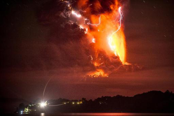
…et sur le site de Time (superbe image!):
https://timedotcom.files.wordpress.com/2015/04/chile-volcano2.jpg?quality=65&strip=color&w=2024
A noter qu’une nouvelle séquence éruptive a eu lieu aux toutes premières heures du 23 avril, comme indiqué dans ce bulletin du SERNAGEOMIN:
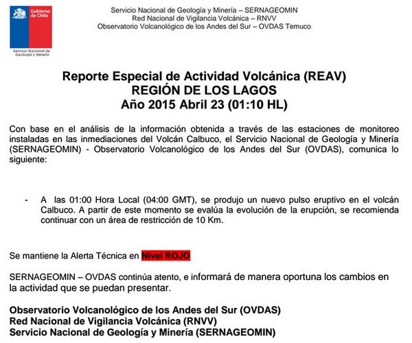
————————————————
 According to an AFP report, the Chilean government declared Red Alert Wednesday after the violent and unexpected eruption of Calbuco volcano, dormant for 43 years and ordered to evacuate the population within a radius of 20 kilometers around.
The Red Alert concerned the cities of Puerto Montt and Puerto Varas, located in the Los Lagos region, about 1,300 kilometers south of Santiago. The evacuation initially concerned about 270 families, according to the authorities, but could be extended in the coming hours to neighbouring towns, which would displace thousands.
Classes were suspended in the region, as well as flights and the arrival in this area.
The alert was also given in southern Argentina. The authorities of the Argentine city of Bariloche, just 100 kilometres from the volcano, have taken emergency measures in anticipation of the possible arrival of ash from the eruption.
The Civil Defense of Bariloche, which is 1630 km south of Buenos Aires, suspended classes in schools and health facilities were requisitioned to deal with any emergency related to the eruption.
The authorities have also decided the state of emergency for disaster in nearby localities of the volcano, and the army will therefore take temporary control of these areas.
The eruption, which began around 18:00, came by surprise, as no activity had been recorded in recent days. According to the Buenos Aires VAAC, the eruptive plume reached 10 km a.s.l.
Live broadcast on television showed a thick column rising into the sky above the volcano, but no lava flow could be seen.
Here are two short videos of the eruption:
https://www.youtube.com/watch?feature=player_embedded&v=_MdUQY6xQG4
http://www.cooperativa.cl/noticias/pais/desastres-naturales/erupciones-volcanicas/testigo-registro-magnitud-de-la-erupcion-del-volcan-calbuco/2015-04-22/183830.html
Photos released by the Journal de Montréal:
http://www.journaldemontreal.com/2015/04/22/alerte-rouge-au-chili-eruption-innatendue-du-volcan-calbuco
…and on the Time website:
https://timedotcom.files.wordpress.com/2015/04/chile-volcano2.jpg?quality=65&strip=color&w=2024
A new eruptive episode occurred early on April 23rd, as can be seen in the SERNAGEOMIN bulletin (see above).
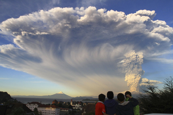
Vue du panache éruptif du Calbuco (Crédit photo: Associated Press)
 En raison de l’augmentation de l’activité de l’Ubinas dont le niveau d’alerte a récemment été élevé à Orange, la Direction Régionale de la Santé a mis au point un plan d’évacuation pour les habitants vivant à proximité du volcan. Vendredi dernier, le volcan avait enregistré un total de sept éruptions au cours des neuf jours précédents.
 Due to the increase in activity of Ubinas whose alert level has recently been elevated to Orange, the Regional Directorate of Health has devised an evacuation plan for the local residents. Last Friday, the volcano had registered a total of 7 eruptions within the previous nine days.

 Claude Grandpey : Volcans et Glaciers
