Plusieurs événements ont été signalés depuis ma dernière note sur l’activité volcanique dans le monde.
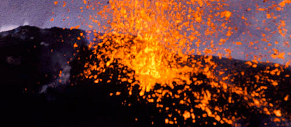
L’éruption du Piton de la Fournaise (Ile de la Réunion) débutée le 19 septembre 2022 s’est arrêtée brutalement vers 10h10 (heure locale) le 5 octobre 2022. Aucune projection de lave n’est visible en surface.
Comme il le fait à l’issue de chaque éruption, l’OVPF ajoute qu’aucune hypothèse n’est écartée quant à l’évolution de la situation à venir (pause de l’éruption, arrêt définitif, reprise de l’activité sur le même site, reprise de l’activité sur un autre site), compte tenu de la forte sismicité qui a été enregistrée ces derniers jours.

Souvenir : Image du cône éruptif et des projections le 27 septembre 2022 (Photo: C. Holveck)
++++++++++
Selon la JMA, les émissions de cendres sur l’île Nishinoshima (Japon) ont augmenté les 2 et 3 octobre 2022, après plus de 12 mois de calme relatif.
Le VAAC de Tokyo a signalé des panaches de cendres s’élevant jusqu’à 1,8 km le 1er octobre. A noter toutefois que les satellites avaient observé une hausse d’activité depuis le 23 septembre. Les émissions se sont poursuivies le 2 octobre, jour où une brève pause a été enregistrée. L’activité a de nouveau augmenté en fin de journée.
Source : Japan Coast Guard
++++++++++
Une hausse d’activité a été observée sur le stratovolcan Sorikmarapi (Nord Sumatra / Indonésie). L’activité volcanique fluctue depuis janvier 2022 et le niveau d’alerte actuel est de 1.
Il y a eu une augmentation du nombre de séismes volcano-tectoniques le 29 septembre 2022, mais il n’y a pas eu d’augmentation de l’activité volcanique en surface.
La hausse de l’activité sismique peut être liée à une augmentation de l’activité hydrothermale et de l’activité magmatique au sein de l’édifice volcanique.
La dernière éruption de ce volcan a eu lieu en 1986, avec un VEI de 1.
Source : CVGHM.

Crédit photo: Wikipedia
++++++++++
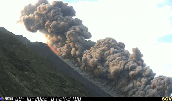
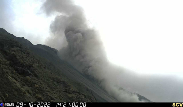
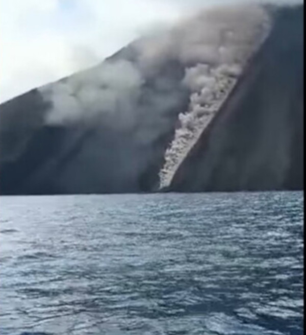
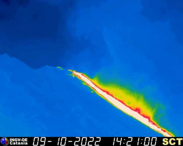
L’INGV a signalé que le 3 octobre 2022, à partir de 9h15 (UTC), un nouveau débordement de lave a été observé au niveau du cratère nord du Stromboli (Sicile), avec une coulée qui a avancé le long de la Sciara del Fuoco. D’un point de vue sismique, il n’y a pas de variation significative de l’amplitude du tremor. Le 5 octobre, la situation est redevenue normale et la lave a cessé de couler le long de la Sciara del Fuoco.

Caméra thermique de l’INGV le 3 octobre 2022
++++++++++
Comme je l’ai écrit précédemment, l’île édifiée par l’éruption de Home Reef (Tonga) ne cesse de s’agrandir. Le 28 septembre 2022, elle avait une superficie d’environ 6 hectares et une hauteur estimée à 15-18 mètres au-dessus du niveau de la mer.
L’île a des flancs escarpés dans sa partie est et une pente plus douce sur la moitié ouest.
Il est conseillé à tous les navigateurs de rester à au moins 4 km du volcan.
La vidéo ci-dessous est une compilation d’images satellites haute résolution montrant l’évolution de Home Reef de juin à septembre 2022.
https://youtu.be/5o_495AS1B8
Source : Services géologiques des Tonga, The Watchers.
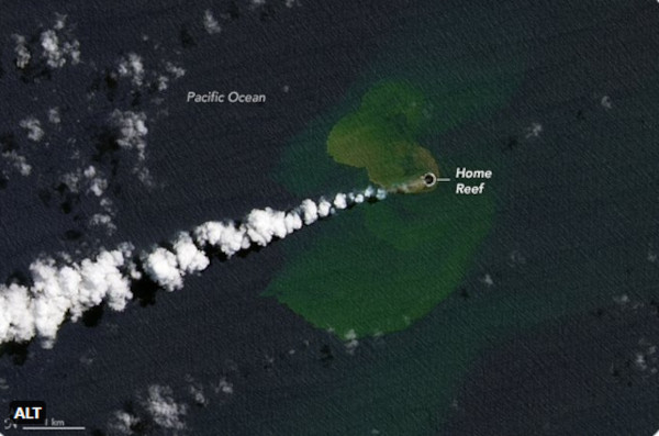
Source : NASA
++++++++++
Dans un bulletin spécial, le PHIVOLCS a signalé que les émissions de SO2 sur le Taal (Philippines) ont atteint 10 718 tonnes par jour le 29 septembre 2022, créant une quantité importante de vog (brouillard volcanique) sur la caldeira. Le bulletin a également indiqué que les émissions de SO2 avaient augmenté depuis le 15 juillet et s’élevaient en moyenne à 6 612 tonnes par jour en septembre. Début août, le dégazage du volcan a augmenté, avec la remontée de fluides chauds dans le lac. Des panaches de vapeur s’élevaient jusqu’à 2,5 km au-dessus de la surface du lac. Le niveau d’alerte reste à 1. Le PHIVOLCS rappelle au public que l’ensemble de Volcano Island est une zone de danger permanent (PDZ).

Vue de Volcano Island (Crédit photo: Wikipedia)
++++++++++
L’éruption du Sabancaya (Pérou) continue. L’IGP fait état d’une moyenne de 46 explosions par jour. Elles génèrent des panaches qui montent en général jusqu’à 3 km de hauteur. La situation ne devrait pas évoluer dans les prochains jours.

Source : IGP
++++++++++
De retour d’une deuxième expédition aux Moluques, Francis Balland m’a communiqué le bilan de ses observations de septembre 2022 sur le Dukono et l’Ibu.
Dukono (15 à 17 septembre):
Au cours de l’ascension vers le camp de base (2 km du sommet) le 15 septembre, le volcan faisait entendre un bruit de dégazage permanent ainsi que plusieurs explosions. Ce fut également le cas lors de la première soirée au camp de base.
Le 16/septembre à l’arrivée au sommet de nuit, le Dukono émettait un panache très important et très chargé de matière.
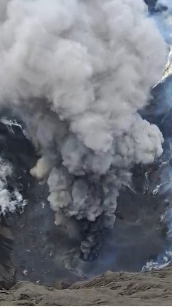
Crédit photo : F. Balland
On pouvait voir au sommet et sur les pentes à l’extérieur du cratère des roches – très légères donc très chargées de gaz au moment de l’expulsion – qui avaient été expulsées lors des explosions entendues la veille.
Le 17 septembre, la situation était totalement différente, le bruit du dégazage était aussi intense mais il n’y avait pratiquement plus de matière dans le panache, essentiellement des gaz
Ibu (20 à 22 septembre):
L’activité était plus intense que lors de la première expédition de juillet
Au cours de la deuxième nuit passée sur le volcan, une explosion ‘’majeure’’ de 7 à 8 mn a projeté beaucoup de matériaux. Le dôme a été totalement recouvert à deux reprises de roches rougies.

Crédit photo : F. Balland
°°°°°°°°°°
Ces informations ne sont pas exhaustives. Vous en trouverez d’autres (en anglais) en lisant le bulletin hebdomadaire de la Smithsonian Institution :
https://volcano.si.edu/reports_weekly.cfm
——————————————–
 Several events have been reported since my previous post about volcanic activity around the world.
The eruption of Piton de la Fournaise (Reunion Island) that started on September 19th, 2022 abruptly stopped on October 5th at about 10:10 (local timpe). No lava projection can be seen at he surface.
As it does at the end of each eruption, OVPF adds that no hypothesis has been ruled out as to the evolution of the future situation (pause of the eruption, definitive cessation, resumption of activity on the same site, resumption of activity on another site), given the strong seismicity that has been recorded in recent days.
Source: OVPF.
++++++++++
According to JMA, ash emissions at Nishinoshima (Japan) increased on October 2nd and 3rd, 2022, after more than 12 months of relative quiescence.
The Tokyo VAAC reported ash plumes rising up to 1.8 km on October 1st. However, satellites had observed an increase in activity since September 23rd. Emissions continued ion October 2nd, when a brief pause was registered. The activity increased again by the end of the day.
++++++++++
Increased activity has been observed at Sorikmarapi stratovolcano (North Sumatra / Indonesia). Activity at the volcano has fluctuated since January 2022, and the current alert level is 1.
There was an increase in the number of volcano-tectonic earthquakes on September 29th, 2022, but there was no visual increase in the activity of the volcano.
This increase in seismic activity may be related to an increase in pressure that can come from hydrothermal activity and magma activity within the volcanic edifice.
The last eruption at this volcano took place in 1986, with a VEI 1.
Source: CVGHM.
++++++++++
INGV reported that on October 3rd, 2022, from 9:15 a.m. (UTC), a new lava overflow was observed at the northern crater of Stromboli (Sicily), with a flow that advanced along the Sciara del Fuoco. From a seismic point of view, there was no significant variation in the amplitude of the tremor. The situation went back to normal on October 5th and lava was no longer flowing along the Sciara del Fuoco.
++++++++++
As I put it before, Home Reef (Tonga) keeps increasing. On September 28th, it had an approximate total surface area of 6 hectares and an estimated height of 15 to 18 meters above sea level.
The island has steep headlands on the eastern half and a smoother slope on the western half.
All mariners are advised to stay at least 4 km from the volcano.
The video below is a compilation of high-resolution satellite images showing Home Reef’s evolution from June to September 2022.
https://youtu.be/5o_495AS1B8
Source: Tonga Geological Services, The Watchers.
++++++++++
In a special report, PHIVOLCS has reported that SO2 emissions at Taal (Philippines) reached 10,718 tonnes per day on September 29th, 2022, creating a significant amount of vog over the caldera. The report also noted that SO2 emissions had been increasing since July 15th and averaged 6,612 tonnes per day in September. In early August degassing at the volcano increased characterized by the upwelling of hot fluids in the lake and steam plumes rising as high as 2.5 km above the lake’s surface. The Alert Level remains at 1. PHIVOLCS warns the public that the entire Taal Volcano Island is a Permanent Danger Zone (PDZ).
++++++++++
The eruption of Sabancaya (Peru) continues. IGP reports an average of 46 explosions per day. They generate plumes that generally rise up to 3 km in height. The situation is unlikely to change in the coming days.
++++++++++
Back from a second expedition to the Moluccas, Francis Balland sent me the results of his observations of September 2022 on Dukono and Ibu volcznoes.
Dukono (September 15th to 17th):
During the ascent to the base camp (2 km from the summit) on September 15th, the volcano made a noise of permanent degassing as well as several explosions. This was also the case during the first evening at base camp.
On September 16th, when arriving at the summit at night, Dukono emitted a very large plume and heavily laden with material.
On the summit and on the slopes outside the crater, one could see rocks – very light and therefore full of gas at the time of the expulsion – which had been expelled during the explosions heard the day before.
On September 17th, the situation was totally different, the noise of the degassing was also intense but there was practically no more material in the plume, essentially gases
Ibu (September 20th to 22nd):
Activity was more intense than during the first July expedition
During the second night spent on the volcano, a « major » explosion of 7 to 8 minutes sent a lot of material. The dome was totally covered twice with red-hot rocks.
°°°°°°°°°°
This information is not exhaustive. You can find more by reading the Smithsonian Institution’s weekly report:
https://volcano.si.edu/reports_weekly.cfm