Volcans du monde // Volcanoes of the world

Plusieurs événements ont été signalés depuis ma dernière note sur l’activité volcanique dans le monde.

Le gouvernement islandais a publié un communiqué concernant l’éruption dans la Geldingadalir. On peut lire que:
« L’éruption fait suite à une activité sismique intense au cours des derniers jours. Elle est considérée comme relativement modeste et, en raison de son emplacement, la menace pour les zones habitées ou les infrastructures essentielles est faible. Cependant, il est possible qu’une pollution soit présente en raison des gaz. Il est donc déconseillé de visiter le site de l’éruption.
Actuellement, il n’y a eu aucune perturbation des vols à destination et en provenance de l’Islande et les couloirs des vols internationaux restent ouverts.
Le site de l’éruption est proche de celui de l’année dernière qui a duré environ six mois. Selon le Met Office islandais, la fissure se trouve dans la Meradalir, à environ 1,5 km au nord du mont Stóri-Hrútur. La zone se trouve dans le sud-ouest de l’Islande, à environ 15 km de l’aéroport international de Keflavik et à environ 25 km de l’agglomération de Reykjavík. »
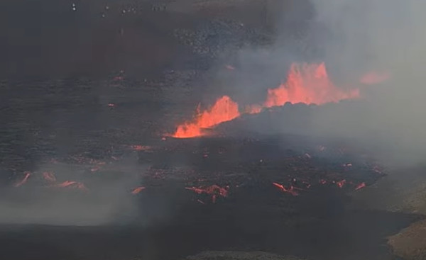
Capture d’écran de la webcam

++++++++++

Le 27 juillet 2022, le Met Office islandais a indiqué qu’un épisode d’inflation avait débuté sur l’Askja en août 2021 et avait atteint aujourd’hui 35 cm dans la partie ouest du lac principal (Oskjuvatn). L’inflation a probablement été provoquée par une intrusion magmatique à une profondeur estimée à 2 km. La sismicité reste faible.
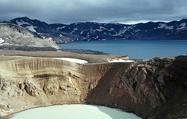
Photo: C. Grandpey

++++++++++

Le Met Office islandais (IMO) signale également qu’une hausse de la sismicité, avec plusieurs événements d’une magnitude supérieure à M 1, 0, a commencé sur le Grímsvötn dans l’après-midi du 2 août 2022 et s’est poursuivie dans l’après-midi du 3 août. L’événement le plus significatif a atteint M 3,6. L’IMO a fait passer la couleur de l’alerte aérienne au Jaune.
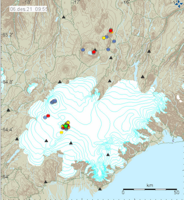
Source: IMO

++++++++++

Le niveau d’alerte du Raung (île de Java / Indonésie) a été relevé de 1 à 2 le 29 juillet 2022 en raison d’une augmentation de la sismicité et des conditions instables au niveau du cratère. Le 27 juillet, un épisode éruptif a éjecté un panache de cendres jusqu’à 1,5 km au-dessus du sommet. De plus, les satellites de la NASA ont détecté une anomalie thermique à la surface du cratère le 28 juillet.
Les données GPS pour la période de juin à juillet 2022 confirment une inflation de l’édifice jusqu’à plus de 10 km du cratère. Il s’agit probablement d’une accumulation de magma à une profondeur d’environ 3 km sous le volcan.
Le public doit reste à moins de 3 km du volcan.
La dernière éruption du Raung a eu lieu en 2021, avec un VEI 2.

Photo: C. grandpey

++++++++++

Les récents séismes – avec un événement de M 4,6 – et un pic d’activité sismique le mois dernier au niveau du volcan sous-marin Kama’ehuakanaloa (autrefois Lo’ihi) n’ont pas affecté l’activité volcanique sur la grande île d’Hawaï. Les ont été causés par le réajustement de la croûte terrestre qui se déforme sous le poids exercé par les volcans de l’île sur la plaque océanique.
La photo ci-dessous montre l’Halema’uma’u, au sommet du Kilauea, le 29 juillet 2022 depuis la lèvre sud-ouest du cratère. On peut voir des fumées abondantes émises par la bouche éruptive la plus à l’ouest, à gauche de la photo. La bouche ouest continue d’alimenter le lac de lave actif; c’est la zone argentée à l’est (à droite) de la bouche ouest. (Source : U.S.G.S.)

Crédit photo; HVO

++++++++++

La JMA a abaissé le niveau d’alerte du Sakurajima (Japon) à 3 (sur une échelle de 5 niveaux) le 27 juillet 2022. Après la puissante éruption du 24 juillet, aucun matériau n’a été éjecté à plus de 2 km du cratère.

Crédit photo: Wikipedia

++++++++++

La JMA indique par ailleurs que le nombre de séismes volcaniques avec des hypocentres près du cratère du Kuchinoerabujima (îles Ryukyu) a commencé à augmenter vers le 30 juillet 2022 et reste élevé. Le niveau d’alerte a été relevé à 2 (sur une échelle de 1 à 5) le 31 juillet.

°°°°°°°°°°

Ces informations ne sont pas exhaustives. Vous en trouverez d’autres (en anglais) en lisant le bulletin hebdomadaire de la Smithsonian Institution :
https://volcano.si.edu/reports_weekly.cfm

——————————————–

Several events have been reported since my previous post about volcanic activity around the world.

The Government of Iceland has issued an announcement regarding the volcanic eruption in Geldingadalir. It says:

« The eruption follows intense seismic activity over the past few days. It is considered to be relatively small and due to its location, there is low threat to populated areas or critical infrastructure. However, it is possible that pollution can be detected due to the gas release so people are advised against visiting the site of the eruption.

Currently, there have been no disruptions to flights to and from Iceland and international flight corridors remain open.

The site of the eruption is close to last year’s eruption that lasted for about six months. According to the Icelandic Met Office, the exact location of the fissure is in Meradalir about 1.5 km north of Mt. Stóri-Hrútur. The area is in southwest Iceland, about 15 km from Keflavik International Airport and about 25 km from the Reykjavík metropolitan area. « 

++++++++++

On 27 July 2022, the Icelandic Met Office stated that uplift at Askja began in August 2021 and since then had totaled 35 cm, centered in the western part of the main lake. The uplift was likely caused by a magmatic intrusion at an estimated depth of 2 km. Seismicity remains low.

++++++++++

The Icelandic Meteorological Office (IMO) also reports that increased seismicity, with several earthquakes with magnitudes above M 1, 0 began at Grímsvötn during the afternoon of 2 August 2022 and continued through the afternoon of 3 August. The largest event reached M 3.6. IMO raised the Aviation Color Code to Yellow.

++++++++++

The alert level for Raung volcano (Java Island / Indonedia) was raised from 1 to 2 on July 29th, 2022 due to an increase in seismicity and unstable conditions at the crater. On July 27th, an eruptive episode ejected ash up to 1.5 km above the summit. In addition, NASA’s satellites detected a thermal anomaly on the surface of the crater on July 28th.

GPS data for the period of June to July 2022 confirms inflation more than 10 km from the crater, suggesting magma accumulating at a depth of about 3 km beneath the volcano.

The public is not allowed to approach the volcano within 3 km

Raung’s last eruption took place in 2021, with a VEI 2.

++++++++++

The recent earthquakes – with an M 4.6 event – and a spike last month in seismic activity at the Kama‘ehuakanaloa (previously called Loihi) seamount have not affected volcanic activity on Hawaii Big Island. They were caused by crustal readjustment, rocks creaking from the weight of the island’s volcanoes pressing down on the oceanic plate.

The photo below shows Halema‘uma‘u crater, at the summit of Kilauea, as seen July 29th, 2022 from the southwest rim. Abundant fumes can be seen coming from the west vent, at the far left side of the photo. The west vent continues to feed the active lava lake, which is the silver-colored area to the east (right) of the west vent. (Source : U.S.G.S.)

++++++++++

JMA lowered the Alert Level for Sakurajima (Japan) to 3 (on a 5-level scale) on 27 July, 2022. After the larger eruption on 24 July, material has not been ejected more than 2 km from the crater.


++++++++++

JMA also reports that the number of volcanic earthquakes with hypocenters near Kuchinoerabujima’s crater (Ryukyu Islands) began increasing around on 30 Jul 2022y and remains elevated. The Alert level was raised to 2 (on a scale of 1-5) on 31 July

°°°°°°°°°°

This information is not exhaustive. You can find more by reading the Smithsonian Institution’s weekly report:

https://volcano.si.edu/reports_weekly.cfm

Eruption sur la péninsule de Reykjanes (suite) // Eruption on the Reykjanes Peninsula (continued)

Le gouvernement islandais a publié un communiqué concernant l’éruption en cours dans la Geldingadalir. On peut lire que:
« L’éruption fait suite à une activité sismique intense au cours des derniers jours. Elle est considérée comme relativement modeste et, en raison de son emplacement, la menace pour les zones habitées ou les infrastructures essentielles est faible. Cependant, il est possible qu’une pollution soit présente en raison des gaz. Il est donc déconseillé de visiter le site de l’éruption.
Actuellement, il n’y a eu aucune perturbation des vols à destination et en provenance de l’Islande et les couloirs des vols internationaux restent ouverts.
Le site de l’éruption est proche de celui de l’année dernière qui a duré environ six mois. Selon le Met Office islandais, la fissure se trouve dans la Meradalir, à environ 1,5 km au nord du mont Stóri-Hrútur. La zone se trouve dans le sud-ouest de l’Islande, à environ 15 km de l’aéroport international de Keflavik et à environ 25 km de l’agglomération de Reykjavík. »

————————————

The Government of Iceland has issued an announcement regarding the volcanic eruption in Geldingadalir. It says:

« The eruption follows intense seismic activity over the past few days. It is considered to be relatively small and due to its location, there is low threat to populated areas or critical infrastructure. However, it is possible that pollution can be detected due to the gas release so people are advised against visiting the site of the eruption.

Currently, there have been no disruptions to flights to and from Iceland and international flight corridors remain open.

The site of the eruption is close to last year’s eruption that lasted for about six months. According to the Icelandic Met Office, the exact location of the fissure is in Meradalir about 1.5 km north of Mt. Stóri-Hrútur. The area is in southwest Iceland, about 15 km from Keflavik International Airport and about 25 km from the Reykjavík metropolitan area. « 

Capture d’écran de la webcam le 4 août 2022 au matin

Nouvelle éruption sur la péninsule de Reykjanes (Islande) // New eruption on the Reykjanes Peninsula (Iceland)

16h00 (heure française) / 14h00 (GMT): : L’intense sismicité observée ces dernières semaines s’est finalement soldée par une éruption. Le magma a atteint la surface vers 13h40 (GMT) dans Geldingadalir sur la péninsule de Reykjanes. Une fissure de plusieurs centaines de mètres s’est ouverte près du Fagradalsfjall, site de la précédente éruption.

Les scientifiques recueillent des informations sur la zone de l’éruption. En attendant, il est demandé aux visiteurs d’être prudents et de ne pas  se rendre sur le site jusqu’à ce que de nouvelles informations soient publiées.

Le Président islandais a bien résumé la situation: « C’est ainsi que les choses se passent ici en Islande. Aujourd’hui, j’ai lu aux informations : « Aucun signe d’éruption pour le moment » à 12h55. Puis la nature prend le dessus (l’éruption a débuté vers 13h40). Maintenant, espérons juste que tout se passera bien et que cette éruption ne causera pas de dégâts. »

Capture écran webcam

Eruption fissurale « à l’islandaise » qui me rappelle celle du Krafla, dans le NE de l’Islande en 1984.

Crédit photo: USGS

°°°°°°°°°°

18 heures (GMT): L’éruption fissurale se poursuit à proximité du Fagradalsfjall et semble avoir adopté un rythme de croisière. La sismicité est moins intense sur la péninsule, tandis que le tremor éruptif s’est stabilisé à un bon niveau.

Une interdiction de vol est actuellement en vigueur au-dessus de la zone,mais il ne devrait s’agir que d’une mesure temporaire pendant l’évaluation des conditions. Selon la Protection civile, l’éruption n’est pas de grande ampleur et se situe à bonne distance des zones habitées et des infrastructures. Les émissions de gaz se dirigent actuellement vers le sud, loin des zones habitées.

Juste une question que ne manqueraient pas de poser les Américains à Hawaii: S’agit-il d’une nouvelle éruption, ou de la suite de la précédente?

——————————

16:00 (French time) / 14h00 (GMT): : The intense seismicity observed during the past weeks has finally ended with an eruption. Magma reached the surface around 13:40 in Geldingadalir in the Reykjanes peninsula. A several hundred-meter long crack has opened close to Fagradalsfjall, the site of the previous eruption.

Scientists are gathering information regarding the area, in the meantime, visitors are asked to be careful and not to visit the site until further news has been published.

The Icelandic President summed up the situation quite well : » « This is how things happen here in Iceland. Today I read on the news: « No signs of eruption at this time » at 12:55 PM, and then Nature just takes the reins. Now we just hope for the best, that this eruption will not cause havoc. »

°°°°°°°°°°

6 p.m. (GMT): The fissure eruption continues near Fagradalsfjall and seems to have adopted a cruising speed. Seismicity is less intense on the peninsula, while the eruptive tremor has stabilized at medium values.

A flight ban is currently in effect over the area, though officials say it is only a temporary measure while conditions are being assessed. According to the Civil Protection, the eruption is relatively small and is located a considerable distance from inhabited areas and infrastructure. Gas emissions are currently streaming south, away from inhabited areas.

Just one question Americans would inevitably ask in Hawaii : Is this a new eruption or the continuation of the previous eruption?

Eruption à court terme sur la péninsule de Reykjanes ? // Short-term eruption on the Reykjanes Peninsula ?

Selon la dernière analyse du Met Office islandais (IMO), la probabilité d’une éruption dans la région de Fagradalsfjall dans les jours ou semaines à venir est à prendre en compte. Cette hypothèse fait suite à l’étude des modèles de déformation obtenus grâces aux satellites. Ils indiquent que le chemin emprunté par l’intrusion magmatique sous le Fagradalsfjall est très peu profond, à environ 1 km sous la surface.
Les modèles montrent que l’afflux de magma est assez rapide, presque deux fois plus rapide que lors de l’éruption de février/mars 2021. L’image InSAR réalisée à partir des données satellitaires Sentinel-1 montre clairement l’intrusion magmatique entre Keilir et le Fagradalsfjall ainsi que la déformation qui a accompagné le séisme de M5.4 à Grindavík le 31 juillet 2022.
La déformation et l’activité sismique semblent ralentir en ce moment, mais une situation semblable a été observée l’année dernière et a été l’un des précurseurs de l’éruption.
L’intrusion magmatique actuelle se produit le long de la bordure nord du chenal magmatique de l’année dernière et s’étend du centre du chenal à mi-chemin jusqu’à Keilir, ce qui explique probablement la sismicité dans cette zone. Le risque éruptif dans la zone autour du Fagradalsfjall dans les jours ou semaines à venir est donc bien réel.
Source: IMO.

———————————————-

According to the latest analysis by the Icelandic Met Office (IMO), the chances of eruption in the area around Fagradalsfjall in the coming days or weeks have increased and are considered significant. This hypothesis follows the study of the deformation models. They indicate that the magma tunnel under Fagradalsfjall lies very shallow, about 1 km below the surface.

The models show that he magma influx is quite fast, nearly double the rate of the previous eruption in February/March 2021. InSAR image made from Sentinel-1 satellite images clearly shows the magmatic intrusion between Keilir and Fagradalsfjall along with deformation parallel to the M5.4 earthquake that occurred at Grindavík on July 31st, 2022.

The deformation and seismic activity seem to be slowing down right now, but this situation looks like what it was last year and was one of the forerunners of the eruption.

The current magma intrusion is taking place along the northern side of the magma tunnel from last year and extends from the center of the tunnel halfway to Keilir, which probably accounts for the earthquakes in that area.. The chances an eruption in the area around Fagradalsfjall in the coming days or weeks have therefore increased.

Source: IMO.

Source: Copernicus

Image InSAR couvrant la période du 20 juillet au 1er août 2022. On voit parfaitement l’intrusion magmatique entre Keilir et Fagradalsfjall ainsi que la déformation qui a accompagné le séisme de M5.4 à Grindavík le 31 juillet 2022.