Agung (Bali / Indonésie): Niveau d’alerte au maximum // Alert level at its highest

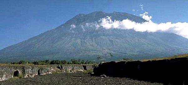
Le 22 septembre, les autorités indonésiennes ont fait passer le niveau d’alerte du Mont Agung au maximum (AWAS), et près de 11 300 villageois ont déjà quitté leurs maisons autour du volcan. Le nombre réel de personnes déplacées est probablement deux ou trois fois plus car beaucoup d’habitants ont volontairement fui leurs maisons.
C’est la troisième fois en un peu plus d’une semaine que le niveau d’alerte est relevé. Selon le Département de Météorologie, Climat et Géophysique, on observe une «augmentation considérable» de l’activité sismique, ce qui indique une forte probabilité d’éruption.
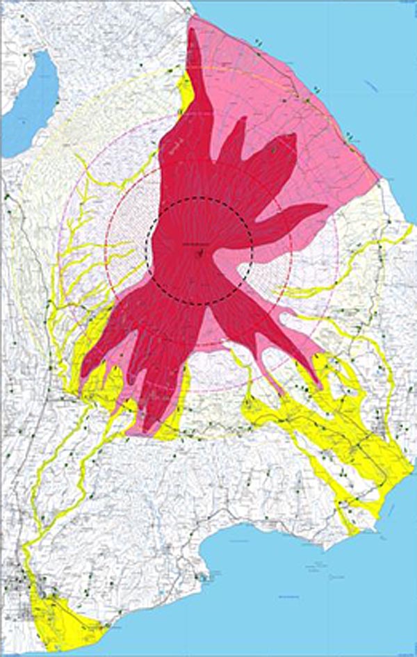
La Protection Civile a rappelé que les habitants ou les touristes ne doivent pas entrer dans la zone de sécurité, donc à moins de 9 kilomètres du cratère et à moins de 12 kilomètres au nord, nord-est, sud-est et sud-sud-ouest.
Les personnes évacuées se trouvent dans des abris temporaires, des centres sportifs, des salles de villages et chez des proches.
Source: Presse indonésienne.

————————————–

On September 22nd, Indonesian authorities raised the alert level for Mount Agung to the highest level (AWAS), and nearly 11,300 villagers have left their homes around the mountain. The real number of displaced might be two or three times that, since many have voluntarily fled their houses.

It was the third time in little more than a week that the alert level was raised. According to the Department of Meteorology, Climate and Geophysics, there has been a « tremendous increase » in the mountain’s seismic activity, indicating a greater probability of an eruption.

The National Disaster Mitigation Agency said no residents or tourists should be within 9 kilometres from the crater and within 12 kilometres to the north, northeast, southeast and south-southwest.

Evacuees are staying in temporary shelters, sports centres, village halls and with relatives.

Source : Indonesian press.

Crédit photo: Wikipedia

Agung (Bali / Indonésie) : Premières évacuations // First evacuations

Selon le journal indonésien The Jakarta Globe, près de 6 000 personnes ont été évacuées ce vendredi des villages près du Mont Agung sur l’île de Bali. La sismicité reste élevée et on peut voir des panaches de gaz au-dessus du cratère. Le VSI indique qu’il y a probablement une ascension du magma vers la surface
Le niveau d’alerte est maintenu à 3 (Siaga) sur une échelle de 4. Les autorités ont demandé aux touristes et aux habitants d’éviter le camping ou la randonnée dans un rayon de 6 kilomètres du cratère.
Les vols à l’aéroport international de Bali fonctionnent normalement et il y a peu de perturbations au niveau des agences touristiques dans le reste de l’île.
On commence à voir le même comportement chez les habitants que lors de l’éruption du Merapi en 2010. Certains villageois au pied de l’Agung ont déclaré qu’ils étaient réticents à partir immédiatement. Ils disent qu’ils doivent rester afin de nourrir leurs animaux

————————————–

According to the Indonesian newspaper The Jakarta Globe, nearly 6,000 people were evacuated this Friday from villages near Mt Agung on the island of Bali. Seismicity is still elevated and smoke can be seen above the crater. There are indications of magma rising to the surface

The alert status is still at 3 (Siaga) on a scale of 4 levels. Authorities have warned tourists and residents to avoid camping or hiking within a 6-kilometre radius from the crater.

Flights at Bali’s international airport are operating as normal and there is little disruption to tourism operators across the rest of the island.

We are starting to see the same behaviour among residents as during the eruption of Mt Merapi in 2010. Some residents in villages at the foot of Mount Agung said they were reluctant to leave immediately. They say they need to stay in order to feed the animals.

Carte à risques de l’Agung (Source: VSI)

Manam (Papouasie-Nouvelle-Guinée // Papua-New-Guinea) : Intensification de l’activité et évacuations

L’Observatoire Volcanologique de Rabaul a informé la Protection Civile à Madang que le niveau d’alerte du Manam a été élevé à 3. Cela signifie que les habitants de l’île doivent être évacuées. L’activité volcanique a augmenté dimanche soir, avec des explosions et des émissions de cendre plus intenses.
Certains habitants de Manam sont retournés dans l’île après des conflits avec les propriétaires fonciers sur le continent. La plupart d’entre eux étaient originaires des villages de Baliau et de Dugulava. Les autorités locales ont commencé à transférer des femmes et des enfants vers le dispensaire Potsdam à Bogia.
Le volcan est entré en éruption vers 19 heures le 16 avril 2017 alors que les habitants de Manam étaient en train de dîner.
Source: The National.

—————————————–

The Rabaul Volcanic Observatory has informed the Disaster Office officials in Madang that the alert level for Manam volcano has been raised to three. This means that people on the island have to be evacuated. Activity at the volcano increased on Sunday, with more explosions and ash emissions.
Some Manam people had moved back to the island after conflicts with landowners on the mainland. Most of them were from Baliau and Dugulava villages. Local authorities have begun moving women and children to the Potsdam Care Centre in Bogia.
The volcano started erupting at about 7 pm on April 16th 2017 while the Manam islanders were having dinner.

Source: The National.

Le Manam en 2017 (Crédit photo: NASA)

Des évacuations sur le Poas (Costa Rica) // Evacuations at Poas Volcano (Costa Rica)

Comme je l’ai écrit dans une note le 7 avril, l’activité du Poas a connu une hausse au cours des derniers jours. L’OVSICORI a conseillé d’augmenter la surveillance et de prendre des mesures de prévention, en particulier dans le parc national.
Un groupe de touristes a dû être évacué dimanche par précaution en raison de l’augmentation des émissions de gaz. Selon les rangers, l’évacuation a eu lieu à 13 heures car certaines personnes se plaignaient d’irritation des yeux et de la gorge.
Le volcan montre une hausse d’activité depuis samedi dernier, avec des fumeroles plus actives et des températures plus élevées. On a également observé plusieurs petites explosions phréatiques. Jeudi, les guides touristiques et le personnel du parc ont confirmé la présence d’une nouvelle fumerole dans le cratère; Ils ont également confirmé un changement de couleur dans le lac principal.
Le parc national  restera ouvert, mais les autorités peuvent ordonner son évacuation en présence d’événements comme celui qui vient de se produire.
Source: The Costa Rica Star.

————————————

As I put it in a note on April 7th, activity at Poas volcano increased in the past days. OVSICORI suggested increasing the surveillance on the volcano and taking prevention measures particularly concerning the Poas National Park.

A large group of tourists had to be evacuated on Sunday from the volcano as a precaution due to the increase in the gas emissions. According to the park rangers the evacuation took place at 1 p.m. as a preventive security measure. Some of the tourists complained about eye and throat irritation caused by the smell.

The volcano has been presenting more activity since last Saturday, the fumaroles are active and the temperature has risen. The volcano has also registered several small phreatic explosions. On Thursday tourist guides and park personnel confirmed the presence of a new fumarole in the crater; they also confirmed a change of colour in the main lake.

The park will remain open for visiting tourists but the park authorities may order evacuation of the same in the presence of events like the one occurred today.

Source: The Costa Rica Star.

Crédit photo: Wikipedia.