 L’Icelandic Met Office a mis en ligne sur son site web (http://en.vedur.is/about-imo/news/2010/nr/1859) un article sur la répartition de la sismicité et le chemin suivi par le magma entre le 13 et le 24 mars.
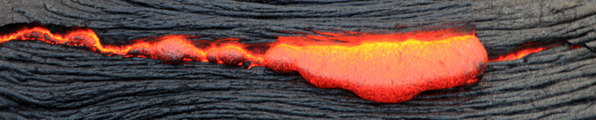
Les graphiques révèlent que le conduit principal d’alimentation de l’éruption actuelle se situe sous la partie orientale du glacier Eyjafjallajökull. Dans un premier temps, il monte verticalement jusqu’à une profondeur de 2 ou 3 km. Il change ensuite de direction pour se diriger horizontalement vers l’est sur une distance d’environ 4,5 km, avant d’atteindre le point où il a percé la surface le 21 mars. On peut raisonnablement penser que ce brutal changement de direction est dû aux nombreuses fractures qui parcourent cette partie de l’Islande, comme le montre l’ouverture d’une nouvelle fissure hier soir. Il faut noter que cette dernière est orientée nord-sud. Il ne semble donc pas que l’éruption ait tendance à migrer vers le Myrdalsjökull et le volcan Katla qui se cache sous le glacier.
 The Icelandic Met Office has released an article about the patterns of seismicity and the path followed by magma at Eyjafjallajökull between March 13th and 24th. (See the Met Office website at this address: http://en.vedur.is/about-imo/news/2010/nr/1859).
Judging from the graphs, it seems that the main feeder conduit of the current eruption is located beneath the eastern part of the Eyjafjallajökull ice-cap and first rises nearly vertically to around a depth of 2 – 3 km. Then, it changes direction to run horizontally eastwards for about 4.5 km to the point where the eruption began on March 21st. One can imagine the change in direction is due to the fracturing in that part of Iceland, as could be seen with the opening of a new fracture last night. One should notice the direction of the new rift is north-south. Thus, it does not look as if the eruption feels like migrating beneath Myrdalsjökull and Katla volcano.
 7 heures
 7:00
7:00
 Selon le KVERT, l’activité sismique est en augmentation depuis le 25 mars. Les données satellitaires révèlent une forte anomalie thermique qui est apparue sur le volcan le 27 mars. Des panaches de cendre ont été observés les 28 et 29 mars. Des explosions accompagnées de nuages de cendre peuvent se produire à tout moment et représenter un danger pour les avions volant à basse altitude.
 According to KVERT, seismic activity at the volcano has been increasing since March 25th. Satellite data reveal a bright thermal anomaly that started over the volcano on March 27th. Ash plumes were noted on March 28th – 29th. Ash explosions can occur at any time and could affect low-flying aircraft.