Eruption dans la Meradalir (Islande) : parking et nouvelles recommandations // Eruption in Meradalir (Iceland): parking and new recommendations

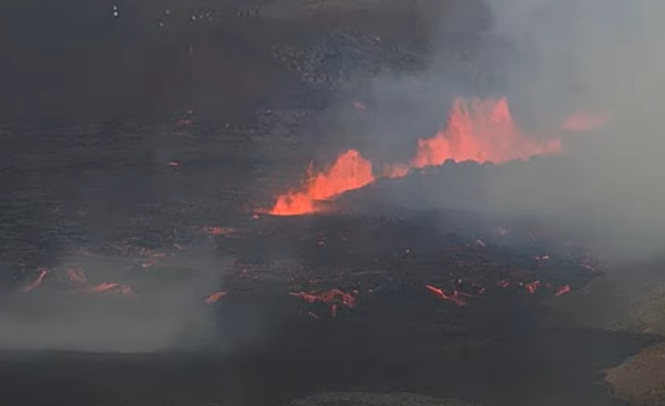
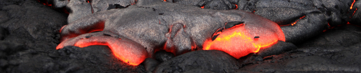
L’éruption dans la Meradalir semble avoir adopté un rythme de croisière. Le Met Office islandais indique que l’éruption dans la Meradalir n’a pas montré de changements significatifs au cours des dernières heures. Le débit de la lave a diminué de près de moitié entre le 3 et le 4 août 2022. Dans les premières heures de l’éruption, il était de 32 mètres cubes par seconde, soit quatre à cinq fois plus qu’au début de l’éruption de 2021. Une autre mesure effectuée le 4 août a révélé que le débit de lave avait chuté à 18 mètres cubes par seconde. A noter que l’année dernière, le début de la rupture s’est produit à partir de plusieurs fissures qui se sont ouvertes jour après jour, alors qu’en 2022 une seule fissure s’est ouverte, du moins pour le moment.
La fissure éruptive active présente toujours une longueur d’une centaine de mètres et la quantité de gaz émise par l’éruption est stable depuis son début. Il y a peu d’activité sismique dans la région.

Bien que les autorités conseillent toujours à ceux qui ne sont pas des randonneurs expérimentés de ne pas se rendre sur le site de l’éruption, un nombre de plus en plus important de touristes ignorent ces recommandations. Beaucoup sont surpris de découvrir que le stationnement n’est pas gratuit et qu’une amende sera infligée à quiconque ne met pas la main au portefeuille
Lors de l’éruption du Fagradalsfjall l’année dernière, il y avait déjà un parking payant quotidien de 1000 ISK (environ 7,00 €) payable via le site Web ou l’application parka.is. Ceux qui ne paient pas sont passibles d’une amende de 4 750 ISK (environ 34,00 €).
Des panneaux sont apposés dans les deux parkings; ils indiquent qu’il y a un tarif journalier pour le stationnement. Un effort est fait actuellement pour améliorer la signalisation. Des caméras et horodateurs vont être installés sur les parkings, similaires à ceux que l’on trouve dans les parkings de la capitale.

L’éruption a lieu dans la vallée de Meradalir, plus à l’intérieur des terres que l’éruption de Fagradalsfjall l’année dernière. Le parcours vers le site est d’environ 17 kilomètres aller-retour et comprend un important dénivelé. Plusieurs personnes ont été blessées ces derniers jours; l’une a dû être évacué par hélicoptère avec une cheville cassée.
La police rappelle au public que le parcours est difficile et pas pour tout le monde. Les secouristes regrettent que de nombreux visiteurs n’apportent pas de lampes de poche.
Ceux qui visitent l’éruption doivent également être particulièrement conscients du risque lié aux gaz. Comme je l’ai déjà écrit, les autorités conseillent aux visiteurs d’éviter d’amener des enfants, qui sont plus sensibles aux gaz toxiques et risquent d’être incommodés car les gaz toxiques lourds s’accumulent près du sol.
La police rappelle également au public que la conduite hors piste est interdite sur le site, comme partout ailleurs en Islande. Plusieurs personnes ont été verbalisées pour ne pas avoir respecté l’interdiction en début de semaine.
Source : Iceland Review.

A titre personnel, j’ajouterai qu’il faut prendre en compte la météo très changeante en Islande. De bons vêtements de pluie sont fortement recommandés.

Les informations sur l’accès au site éruptif se trouvent à cette adresse :

https://claudegrandpeyvolcansetglaciers.com/2022/08/05/islande-comment-acceder-a-leruption-iceland-how-to-reach-the-eruption/

————————————————

The eruption in Meradalir seems to have adopted a cruising speed. The Icelandic Met Office indicates that there have been no changes in the lava flow in the eruption at Meradalir in the past hours. The lava flow decreased by almost half between August 3rd and 4th. The average lava flow in the first hours of the eruption was 32 cubic metres per second, which is four to five times more than at the beginning of the eruption last year. Another measurement on August 4th showed lava flow had dropped to 18 cubic metres per second. It should be noted that last year, the start of the ruption occurred from several fissures which opened day after day, whereas in 2022 only one fissure has opened, at least for the moment.

The active eruptive fissure still appears to be about one hundred meters long and the amount of gas from the eruption remains the same from when it first started. There has been little seismic activity in the area recently.

Although authorities are still advising those who are not experienced hikers to refrain from visiting the eruption, an increasing number of tourists are making their way there. However, many may be surprised to discover that parking is not free and that a fine will be levied against anyone who doesn’t pay for it.

During last year’s Fagradalsfjall eruption, there was aleady a daily parking fee of ISK 1,000 (about €7,00) payable through the parka.is website or app. Those who don’t pay the fee are charged a fine of ISK 4,750 (about €34.00).

Signs are posted in the two parking lots indicating that there is a daily charge for parking. Work is underway to improve the posted signage. Cameras and automated charging systems are expected at the parking lots, similar to those found in capital-area parking garages.

The eruption is located in Meradalir valley, further inland from the Fagradalsfjall eruption that occurred on the Reykjanes peninsula last year. The hike to the site is around 17 kilometres long return and includes considerable elevation. Several people were injured while hiking there in the past days; one had to be evacuated by helicopter with a broken ankle.

The police reminds the public that the hike is difficult and not for everyone. Many visitors are not carrying flashlights.

Those who do visit the eruption also need to be particularly aware of the risk of gas poisoning. As I put it before, authorities advise visitors to avoid bringing children, who are more sensitive to toxic gases and more prone to poisoning, as heavy toxic gases collect closer to the ground.

The police also reminds the public that off-road driving is banned at the site, as everywhere else in Iceland. Several individuals were fined for off-road driving near the eruption earlier this week.

Source: Iceland Review.

I would add that visitors need to take into account the very changeable weather conditions in Iceland. Good rain gear is highly recommended.

Information about access to the eruptive site can be dound at this address:

https://claudegrandpeyvolcansetglaciers.com/2022/08/05/islande-comment-acceder-a-leruption-iceland-how-to-reach-the-eruption/

Capture écran webcam

Islande : comment accéder à l’éruption // Iceland : how to reach the eruption

L’équipe de secouristes de Grindavík a donné une description de la meilleure façon de se rendre sur le site de l’éruption, avec plusieurs conseils.
1. Le meilleur chemin vers le site de l’éruption dépend de la direction du vent et de la météo. Les visiteurs doivent suivre les recommandations de la police et des équipes de secours.
2. Les gens doivent s’assurer qu’ils ont le bon équipement, s’habiller en fonction de la météo, avoir suffisamment de nourriture avec eux, des chaussures appropriées, une lampe frontale et un téléphone portable complètement chargé.
3. Les visiteurs doivent laisser leur voiture sur un parking et non sur le bord de la route.
4. Il y a beaucoup de gaz dans la zone; ils peuvent s’accumuler dans les points bas. Il est donc conseillé d’éviter les secteurs les plus exposés car les gaz peuvent causer des maladies très graves et même des décès.
5. L’ancienne lave de l’éruption de 2021 est encore très chaude et fragile. Il faut l’éviter à tout prix. Si quelque chose arrivait à des personnes sur cet ancien champ de lave, il serait difficile, voire impossible, aux équipes de secours de leur venir en aide.
Le parcours vers le site de l’éruption fait au moins 7 kilomètres (14 km AR) avec un dénivelé d’environ 300 mètres. L’itinéraire est sur sol très dur et il faut gravir des collines très escarpées près du cratère. Le parcours proprement dit peut prendre 4 à 5 heures au moins.
Il faut parcourir environ 5 km pour atteindre le point d’observation d’où le cratère est visible. Il est recommandé de garer la voiture sur le parking à côté du sentier A. Ensuite, il est conseillé aux visiteurs de parcourir le sentier A jusqu’à Fagradalsfjall. Une fois le sommet atteint, il faut avancer dans la plaine jusqu’au volcan.
Des travaux sont en cours pour aménager des sentiers et baliser l’itinéraire afin de le rendre aussi sûr et accessible que possible.
Source : SafeTravel.

—————————————–

The local rescue team from Grindavík has given a description of the best way to go to the volcanic eruption site, with several pieces of advice.

1. The best way to the eruption site depends on the wind direction and weather each time. Visitors should follow the recommendations of the police and rescue teams.

2. People should make sure they have the right equipment, dress according to weather, have a good snack/food with them, appropriate shoes, headlamp and a fully charged mobile phone.

3. Visitors should leave their cars on a parking lot not on the side of the road.

4. There is gas pollution in the area and it could gather where the land is lower than other parts of the land around. It is necessary to avoid the smoke from the volcano since it could cause very serious illness and even fatalities.

5. The “old” lava from the volcano 2021 is still very hot and fragile and dangerous to walk on. It should be avoided at all costs. If something happens to people who risk going on to the “old” lava field from 2021 it is very likely that it would be impossible for search and rescue teams to rescue or help that people.

The hike to the new eruption site is at minimum 7 kilometers one way with an incline of about 300 meters. The route is on very hard terrain and up very steep hills close to the crater. The hike itself can take around 4-5 hours at least.

The hike to the sight seeing platform where the crater is visible is it about 5 km one way, it is best to park the car at the parking lot next to route A. Then visitors are advised to hike route A all the way up Fagradalsfjall and then when they reach the top of the mountain, they can walk the plain towards northwest until they see the volcano.

There is work in progress to make paths and markings for the route to make it as safe and accessible as possible.

Source: Safe Travel.


Source: SafeTravel

Un impact significatif des éruptions sur la péninsule de Reykjanes // A significant impact of the eruptions on the Reykjanes Peninsula

Si l’éruption actuelle ne représente pas une menace pour les zones habitées et les infrastructures, elle est susceptible d’avoir un impact dans un autre domaine. L’activité sismique et volcanique sur la péninsule de Reykjanes sème le doute sur la construction d’un aéroport à Hvassahraun, à mi-chemin entre Reykjavík et l’aéroport international de Keflavík, Jusqu’à présent, le site de Hvassahraun semblait être le plus fiable pour déplacer l’aéroport domestique de Reykjavík qui se trouve à proximité du centre-ville. Quelques heures après le début de la dernière éruption, le ministre islandais des Transports a déclaré qu’il y avait de moins en moins de chances qu’un aéroport soit construit à Hvassahraun.
L’éruption actuelle a lieu près de Fagradalsfjall, où une autre éruption s’est déjà produite l’année dernière. Avant ces deux éruptions, aucune éruption n’avait été observée sur la péninsule depuis près de 800 ans. De plus, les deux éruptions ont été précédées d’une forte sismicité.
Les scientifiques pensent que la péninsule de Reykjanes entre dans une phase d’activité volcanique, ce qui pourrait signifier des éruptions régulières au cours des prochaines décennies, voire des prochains siècles. Le Premier ministre et le ministre des Transports ont déclaré que cette activité doit être prise en compte lors de la planification de construction d’infrastructures telles que les aéroports.
L’éruption du Fagradalsfjall l’année dernière n’a pas été de grande ampleur et n’a causé aucun dégât aux routes ou aux infrastructures. Il en va de même pour l’éruption en cours, au moins jusqu’à présent. Si le débit éruptif actuel ne varie pas, il faudra beaucoup de temps pour que la lave remplisse la vallée de Meradalir et s’écouler vers d’autres zones.
Les autorités discutent de la relocalisation de l’aéroport domestique de Reykjavík depuis des décennies. Hvassahraun a récemment été choisi comme l’emplacement le plus adapté. Les résultats préliminaires d’un groupe de travail qui a évalué la faisabilité d’un aéroport à Hvassahraun sont attendus cet automne. Le groupe a cartographié l’impact d’éventuelles éruptions sur les routes, les infrastructures de transport et d’énergie, ainsi quele transport aérien.
Source : Iceland Review.

———————————————

If the current eruption is no threat to populated areas and to infrastructure, it is likely to have an impact in another sphere. Seismic and volcanic activity on the Reykjanes peninsula affects the viability of building an airport at Hvassahraun, halfway between Reykjavík and Keflavík International Airport, Hvassahraun was previously selected as the most reliable site for relocating Reykjavík City Airport, which is currently located near the city centre. A few hours after the start of the last eruption, Iceland’s Transport Minister stated there are diminishing chances an airport will be built at Hvassahraun.

The current eruption is taking place near Fagradalsfjall, where another eruption occurred just last year. Prior to these two eruptions, no eruptions had occurred on the peninsula for nearly 800 years. Both eruptions were preceded by strong earthquakes.

Experts have stated that the Reykjanes peninsula is entering a volcanically active phase, which could mean regular eruptions over the coming decades or centuries. Both the Prime Minister and Transport Minister have stated this activity is a consideration when planning the construction of infrastructure such as airports.

Last year’s Fagradalsfjall eruption was relatively small and did not cause any damage to roads or infrastructure. The same is true of the ongoing eruption so far. At the current rate of flow, it will take a significant amount of time for the lava to fill Meradalir valley and flow outward to other areas.

Authorities have been discussing relocating Reykjavík City Airport for decades, and Hvassahraun was recently chosen as the most viable location. Preliminary results are expected this autumn from a working group that is evaluating the feasibility of Hvassahraun for a new airport. The group has mapped the impact of possible eruptions on roads, transport and energy infrastructure, and air transport.

Source: Iceland Review.

Crédit photo: Reykjavik City Airport

Volcans du monde // Volcanoes of the world

Plusieurs événements ont été signalés depuis ma dernière note sur l’activité volcanique dans le monde.

Le gouvernement islandais a publié un communiqué concernant l’éruption dans la Geldingadalir. On peut lire que:
« L’éruption fait suite à une activité sismique intense au cours des derniers jours. Elle est considérée comme relativement modeste et, en raison de son emplacement, la menace pour les zones habitées ou les infrastructures essentielles est faible. Cependant, il est possible qu’une pollution soit présente en raison des gaz. Il est donc déconseillé de visiter le site de l’éruption.
Actuellement, il n’y a eu aucune perturbation des vols à destination et en provenance de l’Islande et les couloirs des vols internationaux restent ouverts.
Le site de l’éruption est proche de celui de l’année dernière qui a duré environ six mois. Selon le Met Office islandais, la fissure se trouve dans la Meradalir, à environ 1,5 km au nord du mont Stóri-Hrútur. La zone se trouve dans le sud-ouest de l’Islande, à environ 15 km de l’aéroport international de Keflavik et à environ 25 km de l’agglomération de Reykjavík. »

Capture d’écran de la webcam

++++++++++

Le 27 juillet 2022, le Met Office islandais a indiqué qu’un épisode d’inflation avait débuté sur l’Askja en août 2021 et avait atteint aujourd’hui 35 cm dans la partie ouest du lac principal (Oskjuvatn). L’inflation a probablement été provoquée par une intrusion magmatique à une profondeur estimée à 2 km. La sismicité reste faible.

Photo: C. Grandpey

++++++++++

Le Met Office islandais (IMO) signale également qu’une hausse de la sismicité, avec plusieurs événements d’une magnitude supérieure à M 1, 0, a commencé sur le Grímsvötn dans l’après-midi du 2 août 2022 et s’est poursuivie dans l’après-midi du 3 août. L’événement le plus significatif a atteint M 3,6. L’IMO a fait passer la couleur de l’alerte aérienne au Jaune.

Source: IMO

++++++++++

Le niveau d’alerte du Raung (île de Java / Indonésie) a été relevé de 1 à 2 le 29 juillet 2022 en raison d’une augmentation de la sismicité et des conditions instables au niveau du cratère. Le 27 juillet, un épisode éruptif a éjecté un panache de cendres jusqu’à 1,5 km au-dessus du sommet. De plus, les satellites de la NASA ont détecté une anomalie thermique à la surface du cratère le 28 juillet.
Les données GPS pour la période de juin à juillet 2022 confirment une inflation de l’édifice jusqu’à plus de 10 km du cratère. Il s’agit probablement d’une accumulation de magma à une profondeur d’environ 3 km sous le volcan.
Le public doit reste à moins de 3 km du volcan.
La dernière éruption du Raung a eu lieu en 2021, avec un VEI 2.

Photo: C. grandpey

++++++++++

Les récents séismes – avec un événement de M 4,6 – et un pic d’activité sismique le mois dernier au niveau du volcan sous-marin Kama’ehuakanaloa (autrefois Lo’ihi) n’ont pas affecté l’activité volcanique sur la grande île d’Hawaï. Les ont été causés par le réajustement de la croûte terrestre qui se déforme sous le poids exercé par les volcans de l’île sur la plaque océanique.
La photo ci-dessous montre l’Halema’uma’u, au sommet du Kilauea, le 29 juillet 2022 depuis la lèvre sud-ouest du cratère. On peut voir des fumées abondantes émises par la bouche éruptive la plus à l’ouest, à gauche de la photo. La bouche ouest continue d’alimenter le lac de lave actif; c’est la zone argentée à l’est (à droite) de la bouche ouest. (Source : U.S.G.S.)

Crédit photo; HVO

++++++++++

La JMA a abaissé le niveau d’alerte du Sakurajima (Japon) à 3 (sur une échelle de 5 niveaux) le 27 juillet 2022. Après la puissante éruption du 24 juillet, aucun matériau n’a été éjecté à plus de 2 km du cratère.

Crédit photo: Wikipedia

++++++++++

La JMA indique par ailleurs que le nombre de séismes volcaniques avec des hypocentres près du cratère du Kuchinoerabujima (îles Ryukyu) a commencé à augmenter vers le 30 juillet 2022 et reste élevé. Le niveau d’alerte a été relevé à 2 (sur une échelle de 1 à 5) le 31 juillet.

°°°°°°°°°°

Ces informations ne sont pas exhaustives. Vous en trouverez d’autres (en anglais) en lisant le bulletin hebdomadaire de la Smithsonian Institution :
https://volcano.si.edu/reports_weekly.cfm

——————————————–

Several events have been reported since my previous post about volcanic activity around the world.

The Government of Iceland has issued an announcement regarding the volcanic eruption in Geldingadalir. It says:

« The eruption follows intense seismic activity over the past few days. It is considered to be relatively small and due to its location, there is low threat to populated areas or critical infrastructure. However, it is possible that pollution can be detected due to the gas release so people are advised against visiting the site of the eruption.

Currently, there have been no disruptions to flights to and from Iceland and international flight corridors remain open.

The site of the eruption is close to last year’s eruption that lasted for about six months. According to the Icelandic Met Office, the exact location of the fissure is in Meradalir about 1.5 km north of Mt. Stóri-Hrútur. The area is in southwest Iceland, about 15 km from Keflavik International Airport and about 25 km from the Reykjavík metropolitan area. « 

++++++++++

On 27 July 2022, the Icelandic Met Office stated that uplift at Askja began in August 2021 and since then had totaled 35 cm, centered in the western part of the main lake. The uplift was likely caused by a magmatic intrusion at an estimated depth of 2 km. Seismicity remains low.

++++++++++

The Icelandic Meteorological Office (IMO) also reports that increased seismicity, with several earthquakes with magnitudes above M 1, 0 began at Grímsvötn during the afternoon of 2 August 2022 and continued through the afternoon of 3 August. The largest event reached M 3.6. IMO raised the Aviation Color Code to Yellow.

++++++++++

The alert level for Raung volcano (Java Island / Indonedia) was raised from 1 to 2 on July 29th, 2022 due to an increase in seismicity and unstable conditions at the crater. On July 27th, an eruptive episode ejected ash up to 1.5 km above the summit. In addition, NASA’s satellites detected a thermal anomaly on the surface of the crater on July 28th.

GPS data for the period of June to July 2022 confirms inflation more than 10 km from the crater, suggesting magma accumulating at a depth of about 3 km beneath the volcano.

The public is not allowed to approach the volcano within 3 km

Raung’s last eruption took place in 2021, with a VEI 2.

++++++++++

The recent earthquakes – with an M 4.6 event – and a spike last month in seismic activity at the Kama‘ehuakanaloa (previously called Loihi) seamount have not affected volcanic activity on Hawaii Big Island. They were caused by crustal readjustment, rocks creaking from the weight of the island’s volcanoes pressing down on the oceanic plate.

The photo below shows Halema‘uma‘u crater, at the summit of Kilauea, as seen July 29th, 2022 from the southwest rim. Abundant fumes can be seen coming from the west vent, at the far left side of the photo. The west vent continues to feed the active lava lake, which is the silver-colored area to the east (right) of the west vent. (Source : U.S.G.S.)

++++++++++

JMA lowered the Alert Level for Sakurajima (Japan) to 3 (on a 5-level scale) on 27 July, 2022. After the larger eruption on 24 July, material has not been ejected more than 2 km from the crater.


++++++++++

JMA also reports that the number of volcanic earthquakes with hypocenters near Kuchinoerabujima’s crater (Ryukyu Islands) began increasing around on 30 Jul 2022y and remains elevated. The Alert level was raised to 2 (on a scale of 1-5) on 31 July

°°°°°°°°°°

This information is not exhaustive. You can find more by reading the Smithsonian Institution’s weekly report:

https://volcano.si.edu/reports_weekly.cfm