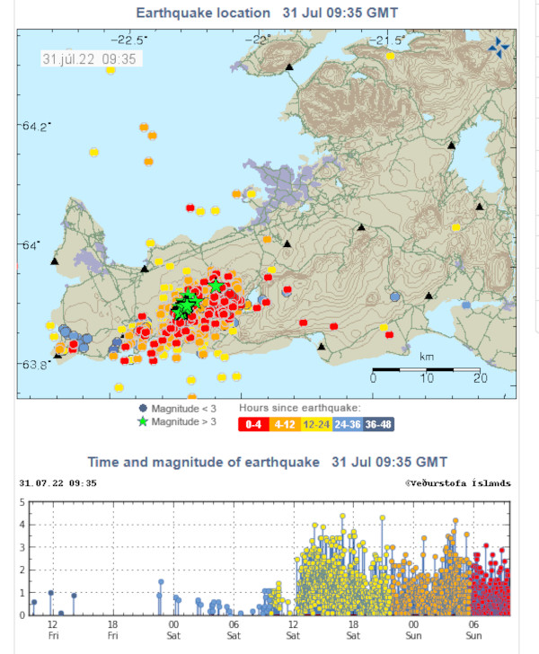
Inflation de l’Askja (Islande) : l’annonce d’une éruption? // Is inflation on Askja Volcano (Iceland) heralding an eruption?

Dans une note publiée le 22 octobre 2021, j’écrivais que l’Askja (Islande) était sous haute surveillance. En effet le volcan connaissait une phase d’inflation et les scientifiques islandais pensaient qu’une éruption ne pouvait être exclue. Depuis début août 2021, l’inflation atteignait 15 cm, soit une augmentation de 7 cm depuis le mois précédent. L’inflation était relativement stable.
A l’époque, les scientifiques du Met Office ont expliqué qu’il était beaucoup trop tôt pour dire s’il fallait s’attendre à une éruption. Cependant, l’inflation signifiait que le magma s’accumulait, très probablement à une profondeur de deux à trois kilomètres.

Des scientifiques de l’Institut des sciences de la Terre, du Met Office islandais (IMO) et des représentants de la protection civile se sont réunis le 25 juillet 2022 pour discuter de la déformation et de la sismicité dans la région de l’Askja au cours des derniers mois.
Une image satellite du volcan a pu être obtenue après la fonte de la neige dans la région. On enregistre une inflation de 35 centimètres, centrée à l’ouest du lac, depuis août 2021.
Bien que l’inflation soit importante par rapport à ce que l’on observe sur des volcans similaires dans le monde, elle ne s’est pas accompagnée d’une hausse de la sismicité. C’est peut-être parce que des décennies avant le début de la période d’inflation actuelle, il y a eu un affaissement persistant du sol dans la région de l’Askja. De plus, une partie de la déformation peut se produire sur des fissures à l’intérieur de la caldeira; ces dernières peuvent se déplacer partiellement sans provoquer d’activité sismique.
Les modélisations indiquent que le magma s’accumule à une profondeur d’environ 2 km et se propage horizontalement dans la croûte terrestre, dans la partie centrale du volcan.
Comme je l’ai écrit précédemment, nous sommes capables d’observer et d’émettre des hypothèses sur le comportement des volcans actifs, mais nous ne sommes pas encore capables de faire des prévisions éruptives fiables. En ce qui concerne les hypothèses, les scénarios futurs possibles concernant l’Askja restent les mêmes que ceux indiqués précédemment.
Si l’accumulation de magma se poursuit, le phénomène peut continuer sans grand changement pendant un certain temps. L’augmentation de l’activité sismique devrait annoncer de nouveaux mouvements du magma en profondeur, voire une éruption. Si cette dernière devait se produire, il s’agirait probablement d’une éruption fissurale à proximité de la caldeira.
Source : The Watchers

————————————————

In a post published on October 22nd, 2021, I wrote that Askja (Iceland) was under high surveillance. Indeed the volcano was experiencing a phase of inflation and Icelandic scientists thought that an eruption could not be excluded. Since the beginning of August 2021, inflation had reached 15 cm, an increase of 7 cm since the previous month. Inflation was relatively stable.
At the time, Met Office scientists said it was far too early to say whether an eruption was to be expected. However, inflation meant that magma was accumulating, most likely to a depth of two to three kilometers.

Scientists from the Institute of Earth Sciences, the Icelandic Met Office (IMO) and civil protection representatives met on July 25th, 2022 to discuss deformation and seismicity in the Askja region in the past few months.
A satellite image of the volcano was obtained after the snow melted in the area. Inflation of 35 centimeters, centered west of the lake, has been recorded since August 2021.
Although the inflation is significant compared to what is seen on similar volcanoes around the world, it has not been accompanied by an increase in seismicity. This may be because decades before the onset of the current inflationary period, there was persistent ground subsidence in the Askja region. Additionally, some of the deformation may occur on fissures within the caldera; they can move partially without causing seismic activity.
Models indicate that magma accumulates at a depth of about 2 km and spreads horizontally in the Earth’s crust, in the central part of the volcano.
As I wrote previously, we are able to observe and hypothesize the behaviour of active volcanoes, but we are not yet able to make reliable eruptive predictions. As far as assumptions are concerned, the possible future scenarios regarding Askja remain the same as those indicated previously.
If the accumulation of magma continues, the phenomenon may continue without much change for some time. The increase in seismic activity might announce new movements of magma at depth, or even an eruption. If the latter were to occur, it would probably be a fissure eruption near the caldera.
Source: The Watchers.

Photos: C. Grandpey


Fonte des glaciers islandais // Melting of Icelandic glaciers

Un bulletin d’information lié au projet Melting Glaciers indique que le glacier Skeiðarárjökull est celui qui a reculé le plus rapidement en 2021 en Islande. Sa langue orientale a perdu a quelque 400 mètres au cours de cette seule année.
Dans son bilan de 2021 sur l’état des glaciers islandais, le Met Office a déclaré que les glaciers reculent depuis au moins un quart de siècle et que ce schéma est la preuve de l’impact du réchauffement climatique dans le pays. La seule exception significative à cette tendance a été en 2015, lorsque les glaciers islandais sont restés en équilibre, ou ont connu une légère croissance.
Depuis 1995, on estime que les glaciers islandais ont perdu 8 % de leur volume total.
Le Breiðamerkurjökull, le glacier qui finit sa course dans le Jökulsárlón, a également subi une perte importante en 2021; il a rétréci d’environ 150 mètres.
Source : Revue islandaise.

——————————————

In a newsletter from the Melting Glaciers project, Skeiðarárjökull was singled out as the fastest-retreating glacier lin 2021, having lost some 400 meters of its eastern tail.

In its 2021 overview of the state of Icelandic glaciers, the Icelandic Met Office stated that glaciers in Iceland have been receding for at least a quarter of a century and that this pattern is one of the clearest forms of evidence for global warming in Iceland. The only significant exception to this trend was in 2015, when Icelandic glaciers were either in equilibrium, or even experienced slight growth.

Since 1995, Icelandic glaciers are estimated to have lost a total of 8% of their total volume.

Breiðamerkurjökull, the glacier that terminates in Jökulsárlón, also experienced significant loss in 2021, shrinking around 150 meters.

Source: Iceland Review.

Glaciers émissaires de la partie sud du Vatnajökull (Source: IMO)

Photo : C. Grandpey

Capture du CO2 en Islande (suite) // CO2 removal in Iceland (continued)

L’Islande est bien connue pour ses efforts de capture du dioxyde de carbone. Dans plusieurs notes sur ce blog (17 juin 2016 ; 26 avril, 22 mai 2021, 5 octobre 2021, par exemple), j’ai décrit le projet CarbFix, situé à côté d’une centrale géothermique à l’extérieur de Reykjavik. L’objectif du projet est d’injecter du CO2 sous terre et de le stocker dans le basalte.
Le 9 septembre 2021, la société suisse Climeworks a mis en service 96 turbines à la centrale Orca. Un dirigeant de l’entreprise a expliqué que dès que les turbines sont actionnées, chaque tonne de CO2 absorbée aide à lutter contre le réchauffement climatique.
En 2022, une nouvelle usine en Islande captera 36 000 tonnes de dioxyde de carbone directement dans l’atmosphère, ce qui décuplera la capture du carbone dans l’air à la centrale géothermique de Hellisheiði. Baptisée Mammoth, la nouvelle installation s’ajoute aux 4 000 tonnes déjà capturées par l’usine Orca, qui a commencé a être opérationnelle en septembre 2021.
La centrale de Hellisheiði est la troisième plus grande centrale géothermique au monde. Depuis 2012, le projet Carbfix capture le dioxyde de carbone directement à partir des émissions de la centrale, en collaboration avec Climeworks (voir ci-dessus). Une fois capturé, le dioxyde de carbone est dissous dans l’eau, injecté dans le sol et transformé en pierre, ce qui l’élimine définitivement de l’atmosphère. En effectuant une capture du CO2 directement dans l’atmosphère, Orca et Mammoth, participent directement à la lutte contre le changement climatique.
Climeworks conduit actuellement des projets pilotes dans le monde entier afin de détecter d’autres sites susceptibles d’accueillir sa technologie de capture du carbone.
Le dernier rapport du GIEC montre que le captage et le stockage du CO2 de l’atmosphère font partie de la plupart des scénarios visant à limiter le réchauffement climatique à 1,5°C d’ici 2100. Le rapport indique que pour atteindre cet objectif, 310 gigatonnes de CO2 devront être retirées de l’atmosphère à cette échéance, d’où l’importance des projets islandais.
Source : médias d’information islandais.

—————————————-

Iceland has long been famous for its efforts to capture carbon dioxide. In several posts on this blog (June 17th, 2016; April 26th, May 22nd, 2021, October 5th, 2021, for instance), I told about the Icelandic CarbFix project, located next to a geothermal power plant outside Reykjavik. The goal of the project was to inject CO2 underground and store it into basalt bedrock.

On September 9th, 2021, the Swiss company Climeworks started operating 96 fans at the plant Orca powered by a nearby geothermal plant. A company executive explained that as soon as the fans were on, every ton of CO2 that is removed would help fight global warming.

In 2022, a new plant in Iceland will capture 36,000 tonnes of carbon dioxide directly out of the atmosphere, increasing the direct air carbon capture at Hellisheiði Power Station tenfold. Named Mammoth, the new facility adds to the existing 4,000 tonnes captured by the plant Orca, which commenced operations at the same location in September 2021.

Hellisheiði Power Station is the world’s third-largest geothermal power plant. Since 2012, the Carbfix project has been capturing carbon dioxide directly from the plant’s emissions, in collaboration with Climeworks. Once captured, the carbon dioxide is dissolved in water, pumped into the ground, and turned to stone, thus permanently removing it from the atmosphere. Orca and Mammoth, however, capture carbon directly from the atmosphere, making them key technologies in the fight against climate change.

Climeworks is currently running pilot projects around the world to determine other suitable locations for their carbon capture technology.

The IPCC’s latest report shows that in addition to significant reductions in emissions, the capture and storage of CO2 from the atmosphere is a necessary component of most scenarios limiting global warming to 1.5°C by 2100. The report states that to reach this goal, up to 310 gigatonnes of CO2 must be captured from the atmosphere by that time. Hence the importance of the Icelandic projects.

Source: Icelandic news media.

Crédit photo: Climeworks

Quelques nouvelles d’Islande // Some news from Iceland

Un séisme de M 4,6 a été enregistré sous le glacier Langjökull dans la soirée du 23 juin 2022. Il a été ressenti dans toute la partie ouest de l’Islande. Une série de répliques a suivi l’événement principal. Le Met Office islandais a localisé la source à 3,7 km de profondeur. Aucun séisme de cette magnitude n’avait été enregistré dans la région depuis 2015, mais un événement supérieur à M 4,0 a été enregistré sur le Geitlandsjökull le 10 décembre de cette même année.
Les séismes atteignent rarement cette magnitude dans la région du Langjökull, bien qu’il existe une certaine activité.
Il semble le séisme soit purement tectonique. La dernière éruption dans la région du Langjökull remonte à 1600 avant J.C.
Source : Iceland Monitor.

°°°°°°°°°°

L’administration islandaise des routes et du littoral a ouvert la route du Landmannalaugar via Sigalda le 23 juin 2022, rendant à nouveau accessible pour l’été le célèbre itinéraire de randonnée de Laugavegur. L’autre point d’accès au Landmannalaugar sera probablement ouvert aux véhicules 4×4 ce week-end.
Même si les pistes ont été ouvertes pour l’été, les conducteurs doivent toujours prendre des précautions lorsqu’ils empruntent les pistes F islandaises et consulter les cartes de l’état des routes de l’IRCA avant de partir.
La Kjölur a été la première des routes des hautes terres à ouvrir cet été, le 10 juin, suivie peu de temps après par la Kaldadalsvegur.

La Sprengisandur a encore beaucoup de neige et ne sera probablement pas ouverte avant juillet.
Source : Iceland Review.

—————————————–

An M 4.6 earthquake was recorded under Langjökull glacier in the evening of June 23rd, 2022. It was felt in all of the western part of Iceland. A series of aftershocks followed the main event. The Icelandic Met Office reported that the source of the earthquake was 3.7 km deep. No earthquakes of this magnitude have been in the area since 2015, but an earthquake above M 4.0 was irecorded at Geitlandsjökull on December 10th that year.

Earthquakes rarely reach this magnitude in the Langjökull area, although there is some activity felt.

It loonks as if the earthquake was purely tectonic. The last eruption in the Langjökull area dates back to 1600 BC.

Source: Iceland Monitor.

°°°°°°°°°°

The Icelandic Road and Coastal Administration opened the road to Landmannalaugar via Sigalda on June 23rd, 2022, making the popular Laugavegur hiking route accessible for the summer. The other point of access to Landmannalaugar will likely be open to 4×4 vehicles by the weekend.

Even if the roads have been opened for the summer, prospective drivers should still take precautions when driving Iceland’s F-roads and consult IRCA’s road condition maps before driving.

The Kjölur route was the first of the highland roads to open this summer, on June 10th, with Kaldadalsvegur soon after. The Sprengisandur route still has copious amounts of snow and likely won’t open until July.

Source: Iceland Review.

Carte de l’état des pistes islandaises: https://www.vegagerdin.is/media/umferd-og-faerd/Halendi.gif