Noël, c’est l’époque des contes populaires que l’on se racontait autrefois au coin du feu. Cette époque est malheureusement révolue et les tablettes ont remplacé les livres de contes. Il est pourtant un pays où cette tradition populaire reste bien ancrée. En Islande, contes et légendes font partie de la culture nationale.
Les elfes sont particulièrement présents dans la vie de ce peuple nordique. Ils habitent souvent dans les rochers ou les cavernes. Ces petits êtres ne sont pas immortels, mais ils ont une espérance de vie beaucoup plus longue que la moyenne des êtres humains. Le petit peuple ou Huldufolk, est très respecté en Islande. Pour beaucoup de gens, les elfes sont bien réels. Même s’ils ne peuvent pas les voir, ils ressentent souvent leur présence.
Pas très loin de Reykjavik, le parc Hellisgerdi à Hafnafjödur est un lieu de résidence des elfes bien connu en Islande. A l’opposé, à l’est, se dresse un rocher, l’Álfaborg, la Cité des Elfes. D’allure majestueuse, il ressemble à une forteresse naturelle. Beaucoup pensent que le rocher est un manoir qui abrite les elfes de haut rang comme le roi et la reine des elfes de l’Est de l’Islande autour desquels virevolteraient une myriade de petits êtres.
Pas très loin de l’Alfaborg se trouve la ferme Jökulsá, du même côté de la rivière Fjarðará. Dans cette ferme vivait autrefois un fermier qui avait une employée nommée Guðrún. Un dimanche, pendant l’été, toute la maisonnée se rendit à l’église, mais Guðrún resta à la ferme. La maîtresse de maison lui avait demandé d’écrémer le lait et de baratter le beurre après avoir rassemblé les moutons et trait les brebis. La famille est allée à l’église et Guðrún a effectué les tâches qui lui étaient dévolues. Elle a ensuite commencé à préparer le dîner et, une fois ses tâches ménagères terminées, elle est sortie effectuer différentes besognes.
Tout à coup, elle vit un grand nombre de personnes passer à cheval le long du chemin juste en dessous de la ferme. Il y avait beaucoup d’hommes qui portaient des vêtements colorés sur de splendides chevaux fougueux. Guðrún fut très surprise car tout le monde devait être à l’église et elle se demanda pourquoi ces gens y partaient si tard.
Toutes ces personnes passèrent sans s’arrêter sauf une femme qui dirigea son cheval vers la ferme Jökulsá. Elle semblait de haut rang et avait belle allure, bien qu’elle fût âgée. Elle salua Guðrún et lui dit : « Donnez-moi du babeurre à boire, ma fille. ». La jeune femme se précipita à l’intérieur de la ferme, remplit de babeurre une cruche en bois qu’elle donna à la femme âgée.
Celle-ci prit la cruche et commença à boire le babeurre. Guðrún lui demanda: « Quel est votre nom ? ». La femme ne répondit pas et avala une autre grande gorgée de babeurre. Guðrún lui posa alors la même question. La femme ne répondit pas et continua à boire.
Lorsque la femme eut suffisamment bu, elle replaça le couvercle sur la cruche. Guðrún se rendit compte qu’elle avait glissé la main sur sa poitrine et avait fait apparaître une belle toile de lin qu’elle plaça sur le couvercle de la cruche avant de la tendre à Guðrún et de la remercier. Puis la jeune femme demanda une troisième fois : « Quel est votre nom ? » « Borghildur est mon nom, jeune fille bien curieuse », répondit la femme en donnant un coup de cravache à sa monture et en s’éloignant de la ferme pour rattraper le reste du groupe.
Guðrún les observa et elle les vit disparaître derrière un rocher gris le long du Kollutungur qui mène à la vallée de Kækjudalur. Quand les gens de la ferme revinrent de l’église le soir, la jeune femme leur raconta ce qui lui était arrivé pendant la journée et elle montra le tissu qui lui avait été donné. Personne n’avait jamais vu un tissu aussi beau et aussi fin.
L’histoire raconte que ce fin tissu s’est transmis entre les plus nobles dames d’Islande à travers les âges. Il se dit que les cavaliers vus par Guðrún étaient des elfes d’Álfaborg sur le chemin de l’église de Kækjudalur et que Borghildur était leur reine…
Légende racontée par Þjóðsögur Jóns Árnasonar dans « La Collection de Folklore de Jón Árnason ».
JOYEUX NOEL A TOUS !
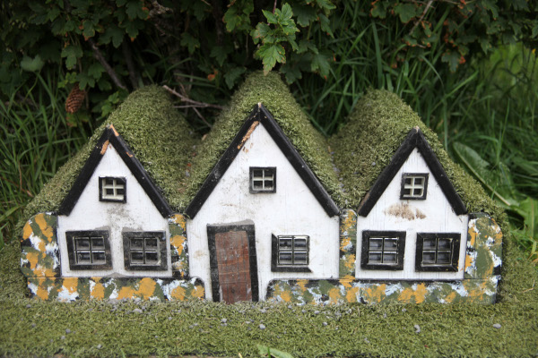
Maisons d’elfes dans le parc Hellisgerdi (Photo: C. Grandpey)
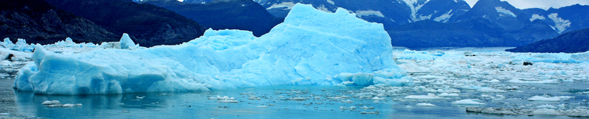
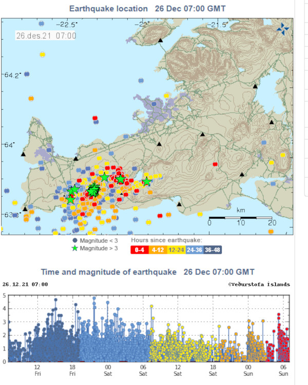
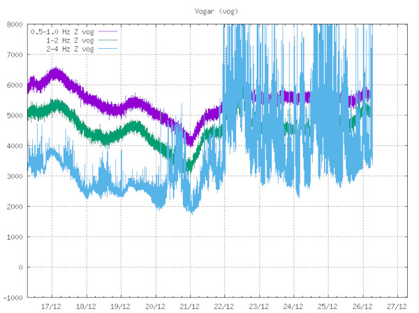
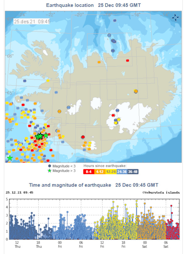
 La sismicité reste soutenue sur la Péninsule de Reykjanes, même si on a observé un certain déclin le 25 décembre. Il est vrai que les essaims se produisent par vague et que cette pause relative n’est peut-être que provisoire. Il est à noter qu’au cours des dernières 24 heures, c’est surtout le secteur de Krysuvik qui a été impacté par les secousses. Comme précédemment, les hypocentres se trouvent à 4 – 5 km de profondeur, ce qui serait (il faut utiliser le conditionnel) en relation avec une intrusion magmatique dans la région. Reste à savoir si le magma réussira à percer la surface. Ayant assisté à l’avortement d’une éruption dans la région du Krafla, je reste extrêmement prudent dans mes prévisions…
 Seismicity remains strong over the Reykjanes Peninsula, although some decline was observed on December 25th. Swarms do occur in waves and this relative pause may only be temporary. It should be noted that over the past 24 hours, the Krysuvik area has been affected by the tremors. As before, the hypocenters are located at depths of 4 – 5 km, which would be (the conditional must be used) in relation to a magmatic intrusion in the region. It remains to be seen whether magma will succeed in piercing the surface. As I have lived the abortion of an eruption in the Krafla area, I am very cautious in my predictions…