Dépêchez-vous de profiter de la nature sauvage à Krýsuvík (Islande) ! // Hurry up to enjoy wild nature in Krýsuvík (Iceland) !

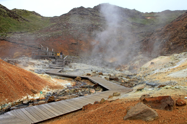
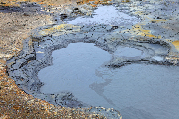
Krýsuvík est une zone géothermale bien connue sur la péninsule de Reykjanes. Comme beaucoup d’autres sites à proximité, elle se trouve sur la dorsale médio-atlantique. La zone englobe plusieurs sites géothermaux parmi lesquels Seltún est le plus visité par les touristes. Des sentiers en bois ont été installés afin de parcourir ce lieu en toute sécurité parmi les fumerolles, les sources d’eau bouillante et les marmites de boue.
Krýsuvík sera peut-être la solution pour résoudre une pénurie d’eau chaude dans la région de Reykjavik dans les prochaines années. Dans ce but, il existe un projet de construction d’une centrale géothermique à Krýsuvík. L’idée a été suggérée par un groupe de travail nommé par la ville de Hafnarfjörður, et dont la mission était d’étudier l’utilisation potentielle de la zone de Krýsuvík.
Le rapport du groupe de travail indique que la faisabilité de la construction d’une centrale géothermique doit être analysée, en prenant en compte la rentabilité d’une telle centrale qui produirait jusqu’à 100 mégawatts (MW) d’électricité et jusqu’à 300 mégawatts thermiques (MWth) d’eau chaude.
Le groupe de travail souligne qu’avant d’entreprendre un tel projet, les habitants de la région devront recevoir une présentation détaillée de ses avantages et inconvénients. La construction d’une centrale électrique à Krýsuvík a longtemps été dans les tuyaux. La compagnie d’électricité HS Orka a obtenu une licence de recherche concernant l’utilisation possible de l’électricité.
En plus de souligner la possibilité d’une station géothermique, le groupe de travail insiste sur l’importance d’améliorer les installations touristiques dans la région. Il faudrait améliorer la route, aménager un parking et une plate-forme d’observation, avec éventuellement un restaurant à proximité de la plate-forme.
Source : Iceland Monitor.

————————————-

Krýsuvík is a geothermal area located on the Reykjanes peninsula. Like many other sites nearby it is located on the Mid-Atlantic Ridge. The area consists of various geothermal fields among which Seltún is the most popular among tourists. Wooden pathways have been installed which allow to safely walk between the numerous fumaroles and mud pots with their boiling water.

Krýsuvík might be a future solution to solve a future shortage of hot water in the capital area. There is a project consisting in building a geothermal power station on the site. the idea has been suggested by a task force appointed by the town of Hafnarfjörður to analyze potential utilization of the Krýsuvík area.

The task force’s report states that the feasibility of building a geothermal power plant must be analyzed, looking at the potential profitability of building a power station that would produce up to 100 MW of electricity and up to 300 MWth of hot water.

The task force emphasizes that before any such project were to be undertaken, residents would first have to be given a detailed presentation of its pros and cons. Building a power plant in Krýsuvík has long been a potential project. The power company HS Orka has obtained a research license in the area regarding possible power utilization.

In addition to pointing out the possibility of a geothermal station, the task force stresses the importance of improving facilities for tourists in the area. That includes the need for an improved road, a parking lot and observation platform and even a restaurant near the platform.

Source: Iceland Monitor.

Photos: C. Grandpey

Grimsvötn (Islande) : pas d’éruption en vue pour le moment // No eruption in the short term

Le 6 décembre 2021, le Met Office islandais a fait passer la couleur de l’alerte aérienne du Grimsvötn du Jaune à l’Orange. Le but des codes de couleurs est d’informer le secteur aéronautique de la situation sur un volcan. La couleur Orange signifie que « le volcan présente des signes d’activité avec un fort risque d’éruption », ou qu' »une éruption volcanique est en cours sans émission de cendres ou avec une faible émission de cendres ». En Islande, le Grímsvötn est actuellement le seul volcan en couleur Orange. L’Askja et le Fagradalsfjall sont en Jaune. Tous les autres volcans sont en Vert.
Il faut garder à l’esprit que lla couleur d’alerte aérienne Orange n’est qu’une mesure de prévention et n’indique pas qu’une éruption est sur le point de se produire. L’IMO a précisé qu’il n’y a actuellement aucune activité sismique annonçant une éruption à court terme. Cependant, le volcan doit être étroitement surveillé. En effet, une éruption du Grímsvötn a parfois suivi une crue glaciaire.
De manière assez logique, le tracé du tremor a montré une ascension régulière correspondant à l’augmentation du débit de la rivière Gígjukvísl. La crue a culminé le 5 décembre au matin. Ensuite, le tremor et le débit de l’eau de fonte ont commencé à diminuer. La sismicité est actuellement faible dans la région du Grimsvötn.

———————————————-

On December 6th, 2021, the Icelandic Met Office changed Grimsvötn’s aviation color code from Yellow to Orange. The aim of the color codes is to inform the aviation sector about a volcano’s status. The Orange color code means that « the volcano is exhibiting heightened unrest with increased likelihood of eruption », or that « a volcanic eruption is underway with no or minor ash emission. » In Iceland, Grímsvötn is currently the only volcano with an Orange color code. Askja and Fagradalsfjall are Yellow. All the the other volcanoes are marked Green.

One should keep in mind that the Orange color code is only a prevention measure and not an indication that an eruption is about to occur. IMO has specified that there is currently no seismic activity announcing an eruption in the short term. However, the volcano needs to be closely monitored. Indeed, a volcanic eruption in Grímsvötn has sometimes followed a glacial outburst flood.

In a fairly logical way, the tremor curve showed a regular rise corresponding to the increasing output of the Gígjukvísl river. The flood peaked on December 5th in the morning. Then, both tremor and meltwater output started decreasing. Seismicity is currently low in the Grimsvötn area.

Source : IMO

Crue glaciaire du Grimsvötn (Islande) [suite] // Grimsvötn’s glacial outburst flood (Iceland) [continued]

La crue glaciaire, ou jökulhlaup, qui a commencé lorsque la calotte glaciaire au-dessus du Grímsvötn a commencé à fondre il y a 11 jours, devrait atteindre son maximum le dimanche 5 décembre 2021. Les autorités islandaises ne croient pas que cette crue affectera la circulation sur la route n°1, ni que des routes devront être fermées.
Le 3 décembre au matin, la calotte glaciaire du Grímsvötn s’était affaissée de plus de 27 mètres et le débit de la rivière Gígjukvísl atteignait 1600 m3/s. La conductivité électrique de la rivière a également augmenté, avec plus de 464 µS/cm ce même jour. Les concentrations de gaz autour du glacier ont révélé des niveaux supérieurs à la normale, mais ne posent actuellement aucun danger.
La question est de savoir si la crue glaciaire sera suivie d’une éruption volcanique, mais personne n’est en mesure de répondre. Nous savons juste que dans le passé, les éruptions du Grímsvötn ont commencé dans le sillage d’une crue glaciaire. En effet, l’évacuation de l’eau réduit la pression au sommet du volcan et cela peut favoriser le déclenchement d’une éruption. Un tel événement s’est produit en 1922, 1934, et plus tard, en 2004. Les scientifiques ont remarqué qu’il y avait eu un accroissement de la sismicité avant l’éruption. Pour le moment, aucun événement de ce type n’a été détectée autour du volcan.
Source : Iceland Review.

——————————————

The glacial outburst flood, or jökulhlaup, which started when the ice sheet in Grímsvötn beneath Vatnajökull glacier began to melt 11 days ago, is predicted to reach its peak on Sunday, December 5th, 2021. .Icelandic authorities do not believe that the runoff will affect traffic on Route 1, nor that roads will need to be closed.

On DEcember 3rd in the morning, the Grímsvötn ice sheet had sunk over 27 meters and was flooding the Gígjukvísl river at a rate of 1600 m3/s. The electrical conductivity of the river has also been increasing and was measured above 464 µS/cm on that same day. The gas concentrations along the perimeter of the glacier have been measured at higher than normal levels, but do not currently pose a danger.

The question is to know whether the glacial outburst flood will be followed by a volcanic eruption, but nobody is able to answer the question. We just know that in the past eruptions at Grímsvötn have begun following a glacial outburst flood. Indeed, the evacuation of the water reduces the pressure on top of the volcano and this can allow an eruption to begin. It happened in 1922, 1934, and later, in 2004. Scientists have noticed that there was a series of earthquakes before the eruption. For the moment, no such seismicity has been detected around the volcano.

Source: Iceland Review.

Source: IMO / Wikipedia

Signes d’inflation sur la péninsule de Reykjanes (Islande) // Signs of inflation on the Reykjanes Peninsula (Iceland)

Les volcanologues islandais indiquent que des signes d’inflation ont été détectés sur la péninsule de Reykjanes. Le phénomène a été observé au nord du mont Keilir et au sud du site de l’éruption de Fagradalsfjall. Le sol autour de Fagradalsfjall a connu une déflation pendant l’éruption proprement dite, très probablement à cause de l’évacuation du magma vers la surface.
D’après les mesures GPS, le processus de déflation a commencé à s’atténuer fin août, puis à se transformer en inflation vers la mi-septembre. Cette dernière est cependant minime, avec un maximum de seulement un à deux centimètres.
Selon les modèles du Met Office, l’accumulation de magma dans les profondeurs de la terre est la cause la plus probable de l’inflation, bien que les scientifiques pensent également qu’elle peut être liée à une période d’activité sismique d’un mois à l’extrémité sud de ma montagne de Keilir à la fin septembre.
L’accumulation de magma sous les systèmes volcaniques se produit parfois après des éruptions. En tant que telle, l’inflation actuelle n’indique pas forcément que le magma se déplacera vers la surface dans un proche avenir. Ce processus peut prendre des années, voire des décennies, et il est difficile pour les scientifiques de faire des prévisions avec beaucoup de précision.
Aucune coulée de lave n’a été observée sur le site de Fagradalsfjall depuis le 18 septembre 2021. Des émissions de gaz sont toujours détectées, mais en très faible quantité.
Source : Iceland Review.

—————————————

Icelandic volcanologists indicate that land has started rising again on the Reykjanes peninsula. The inflation has been detected north of Mt. Keilir and south of the Fagradalsfjall eruption site. The land around Fagradalsfjall fell during the eruption itself, most likely because of the magma streaming out of the chamber beneath the surface.

According to GPS measurements, the deflation process began to subside at the end of August and then turn again into inflation around the middle of September. The uplift is, however, minimal, with only one to two centimetres at the highest points.

According to the Met Office’s models, the magma accumulation deep within the earth is the most likely cause of the inflation, although scientists also believe that it is connected to a month-long wave of seismic activity that began at the southern end of Keilir at the end of September.

Magma accumulation under volcanic systems sometimes occurs after eruptions. As such, the current inflation is not necessarily an indication that magma will move toward the surface in the near future. This process may instead take years or even decades, and it is difficult for scientists to make predictions with much accuracy.

There has been no lava flow at Fagradalsfjall since September 18th, 2021. Gas emissions are still being detected at the eruption site, but only in very small quantities.

Source: Iceland Review.

Calme plat sur le site de Fagradalsfjall (Capture écran webcam)