Islande: Fin du suspense? // Iceland: End of the suspense?

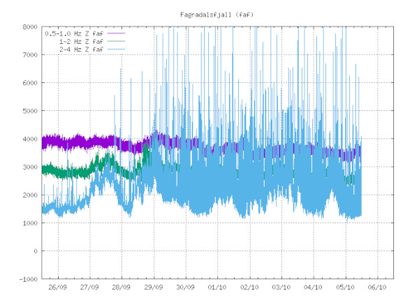
La situation a l’air de bien se calmer en Islande et va peut-être mettre fin à l’angoisse des volcanologues locaux qui se posent beaucoup de questions sur l’avenir de l’éruption de Fagradalsfjall. Cela fait maintenant plus de deux semaines qu’aucune coulée de lave n’est observée sur le site. Le cratère principal se contente de dégazer tranquillement et ne montre pas la moindre velléité de réveil. La sismicité est en train de décliner dans la région et le tremor ne montre plus la même ardeur.

L’apparition d’une sismicité relativement intense à proximité du site éruptif initial a fait croire à une migration du magma et à la réapparition de la lave dans le secteur de Keilir. Au moment où j’écris cette note, aucun événement significatif n’est observé dans la région. En particulier, les satellites n’ont pas détecté d’inflation ou de déformation du sol.

Y a-t-il eu une intrusion magmatique comme l’ont affirmé certains? Mystère et boule de gomme. L’intrusion, a-t-elle effectivement eu lieu avec un manque de pression du magma, ce qui lui aurait empêché de percer la surface? Allez savoir!

La sismicité était-elle d’origine tectonique? Pourquoi pas? Comme je l’ai déjà signalé, la Presqu’île de Reykjanes est complexe car il y a une cohabitation entre la tectonique d’accrétion de l’Islande et un volcanisme potentiel. C’est d’ailleurs ce double aspect qui a fait beaucoup hésiter les scientifiques islandais avant que l’éruption se déclenche le 19 mars 2021. Ils se sont longtemps demandé s’il s’agissait effectivement d’une intrusion magmatique avec présence d’un dyke.

Heureusement, ces tergiversations sont sans danger car la région est très faiblement peuplée. Au pire, la lave aurait pu couper la route côtière au moment de l’éruption de Fagradalsfjall. Elle aurait pu couper la route conduisant à l’aéroport de Keflavik si une éruption avait eu lieu dans le secteur de Keilir.

Avec un peu de recul, on se rend compte qu’il reste un très long chemin à parcourir dans le domaine de la prévision volcanique…

——————————————-

The situation seems to be calming down in Iceland and perhaps will put an end to the anxiety of local volcanologists who have asked many questions about the future of the Fagradalsfjall eruption. It has now been more than two weeks since no lava flow has been observed at the site. The main crater is only degassing quietly and does not show the slightest hint of waking up. Seismicity is declining in the region and the tremor is decreasing as well.
The intense seismicity that was recorded near the initial eruptive site suggested a migration of magma and that lava might pierce the surface in the Keilir area. As of this writing, no significant events are observed in the region. In particular, the satellites did not detect any ground deformation or inflation.
Was there a magma intrusion as some have claimed? Nobody knows. Did the intrusion actually take place with a lack of pressure from the magma, which prevented it from piercing the surface? Who knows!
Was the seismicity of tectonic origin? Why not? As I have already pointed out, the Reykjanes Peninsula is complex because there is a mixture of Icelandic accretion tectonics and a potential volcanism. This dual aspect also caused Icelandic scientists to hesitate a lot before the eruption started on March 19th, 2021. They wondered for a long time whether it was indeed a magmatic intrusion with the presence of a dyke.
Fortunately, these procrastinations are harmless because the region is very sparsely populated. At worst, lava could have cut off the coastal road at the time of the Fagradalsfjall eruption. It could have cut off the road to Keflavik airport if an eruption had occurred in the Keilir area.
Looking back, one realizes that there is still a very long way to go in the field of volcanic prediction…

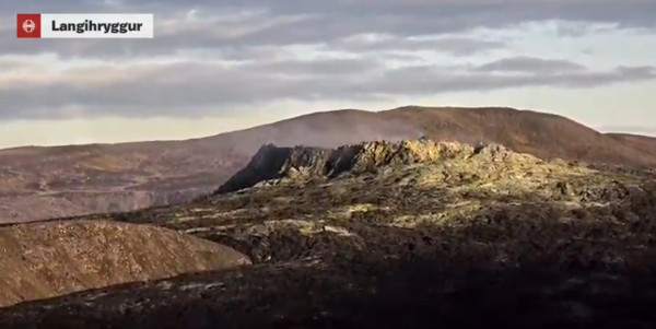
Capture écran webcam

Beaucoup de questions sur la situation en Islande ! // So many questions about the situation in Iceland !

Depuis le 18 septembre 2021, plus aucune lave n’est émise par le cratère actif de Fagradalsfjall. Il s’agit de la plus longue pause d’activité depuis le début de l’éruption. Il s’agit peut-être de la fin de l’éruption mais il est encore trop tôt pour l’affirmer. Les scientifiques se posent des questions sur l’activité sismique et volcanique sur la péninsule de Reykjanes depuis bien avant le début de l’éruption du 19 mars 2021. Lorsque la lave a été observée pour la dernière fois, elle se déplaçait à l’intérieur du nouveau champ de lave. En conséquence, le champ de lave s’est affaissé de 5 à 7 mètres dans sa partie nord et s’est soulevé dans le même temps au sud dans les vallées de Geldingadalir et Nátthagi.
Selon les géologues islandais, l’éruption peut être divisée en cinq périodes distinctes.Elle a commencé par deux semaines de coulées de lave ininterrompues avec un débit effusif d’environ six mètres cubes par seconde.
Cette première période a été suivie de deux semaines au cours desquelles de nouvelles fissures se sont ouvertes au nord de la fissure d’origine. La lave avait alors un débit variable entre cinq et huit mètres cubes par seconde. Selon les jours, elle a coulé dans les vallées de Geldingadalir, Meradalir ou Nátthagi.
La phase suivante a consisté en une émission de lave constante pendant environ deux mois et demi, avec un débit effusif de 12 mètres cubes par seconde. La lave s’est écoulée tantôt dans la Geldingadalir, tantôt da,s la Meradalir ou la vallée de Nátthagi.
Une activité irrégulière directement liée au flux de magma sous la surface a commencé fin juin. le débit éruptif a commencé à varier de 8 à 11 mètres cubes par seconde, avec des pauses prolongées.
La dernière pause marque peut-être la fin de l’éruption. Des arrêts dans l’activité éruptive ont déjà été observés du 2 au 11 septembre, puis il y a eu une semaine d’activité intense jusqu’au 18, suivie d’une nouvelle longue interruption d’activité qui se poursuit aujourd’hui.
Les scientifiques ne savent pas si la cinquième étape se soldera par l’extension de l’intrusion magmatique vers le nord avec le début d’une nouvelle éruption. Ce scénario est en ce moment considéré comme plus probable que celui selon lequel l’essaim sismique s’expliquerait par un simple réajustement tectonique dans la région.
L’essaim était principalement centré autour de Keilir ces derniers jours. Les événements les plus significatifs avaient des magnitudes comprises entre M 3,0 et M 3,5.
Source : ruv.is.

Notre capacité à prévoir les éruptions volcaniques est encore très faible et personne ne sait ce qui se passera sur la péninsule de Reykjanes. L’éruption va-t-elle se réactiver ? L’essaim sismique va-t-il déclencher une nouvelle éruption ? S’arrêtera-t-il comme il a commencé parce qu’il avait une origine purement tectonique ? Aujourd’hui, personne n’est en mesure de répondre à ces questions !

————————————————

No lava has been erupted by the active crater at Fagradalsfjall since September 18th, 2021. This is the longest pause in activity since the eruption started. It might also indicate the end of the eruption but it is still too early to affirm it. Seismic and volcanic activity on the Reykjanes Peninsula has puzzled scientists before the eruption began on March 19th, 2021. When lava was last detected, it was moving within the new lava field. As a consequence, the lava field has sunk by 5-7 metres at its northern end and risen to the south in Geldingadalir and Nátthagi.

According to Icelandic geologists, the eruption can be split into five distinct periods that started with two weeks of steady lava flow of around six cubic metres per second.

This was followed by another two-week period in which new fissures opened to the north of the original one and the flow rate was variable between around five and eight cubic metres per second. The lava flowed variously into Geldingadalir, Meradalir, or Nátthagi.

The next phase was a steady lava flow for around two-and-a-half months of 12 cubic metres per second; also flowing variously into Geldingadalir, Meradalir, or Nátthagi.

Irregular activity directly related to magma flow below the surface started in late June, when lava flow started varying wildly from 8-11 cubic metres per second, with extended pauses.

The latest stage may or may not be the closing stage; as in September there was a total stop in the eruption from the 2nd to the 11th, then a week of excited activity until the 18th, followed by another long pause that is ongoing today.

Scientists don’t know whether the fifth stage will be the extension of the lava intrusion to the north and the start of a whole new volcanic eruption. This scenario is now believed somewhat more likely than the other explanation that the seismic swarm is simple tectonic readjustment in the area.

The swarm was mostly centered around Keilir in the past days. The most significant events had magnitudes ranging between M 3.0 and M 3.5.

Source: ruv.is.

Our ability to predict eruptions is still very low and nobody knows what will happen on the Reykjanes Peninsula. Will the eruption reactivate? Will the seismic swarm trigger a new eruption? Will it stop like it began because it was purely tectonic? Today, nobody is able to answer these questions!

Le tremor dans le secteur de Fagradalsfjall (Source: IMO)

Islande : on patauge dans la sismicité ! // Iceland : wallowing in seismicity !

Heureusement qu’aucune zone habitée n’est menacée car les scientifiques islandais sont incapables d’expliquer les causes et de prévoir les conséquences de la sismicité qui affecte actuellement le sud-ouest de leur île. Un essaim sismique avec plusieurs événements significatifs a secoué la région tandis que l’éruption de Fagradalsfjall est en pause depuis près de deux semaines et personne ne sait pourquoi.
Un nouveau séisme de magnitude M 3,7 a secoué la région à 02h07 le 1er octobre 2021. Son épicentre était à 1,2 km au sud-sud-ouest du Keilir. Il a été précédé d’une autre secousse de magnitude M 3,2 à 22h10 le 30 septembre. La source se trouvait à 0,7 km au sud-sud-ouest du Keilir. Au total, sept séismes de magnitude 3 ou plus ont été enregistrés dans la région depuis le 27 septembre. .
Les images satellites InSAR les plus récentes ne montrent aucun signe d’intrusion magmatique en lien avec l’essaim sismique. Une intrusion de magma n’est cependant pas à exclure, car il faut généralement quelques jours pour que l’inflation apparaisse.
Les volcanologues islandais expliquent qu’il est trop tôt pour faire une prévision et pour dire si l’activité sismique actuelle pourrait évoluer comme elle l’a fait en février, lorsqu’elle a débouché sur l’éruption de Fagradalsfjall le 19 mars.
Ce qui est inquiétant, c’est qu’il y a eu un désaccord entre les scientifiques lors d’une réunion qui a eu lieu le 30 septembre. Certains ont déclaré que l’activité sismique actuelle impliquait une intrusion magmatique tandis que d’autres étaient sûrs qu’elle était causée par des mouvements à la limite des plaques tectoniques. Ces désaccords me rappellent les médecins du 17ème siècle qui avaient des opinions différentes sur la maladie d’un patient ! Quoi qu’il en soit, les jours à venir diront qui a raison et tort.
Comme je l’ai écrit précédemment, au cours des derniers jours, il n’y a eu aucune activité volcanique visible sur le site éruptif de Fagradalsfjall, à l’exception d’un dégazage du cratère. Lorsqu’on leur demande si l’essaim sismique actuel pourrait annoncer le début d’une nouvelle phase éruptive, les volcanologues répondent qu’il est encore trop tôt pour le dire.
Contrairement à l’essaim sismique de février, l’activité actuelle se concentre dans une zone beaucoup plus réduite. En février, ion a enregistré des séismes dans de nombreuses zones de la péninsule de Reykjanes. Il y a aussi beaucoup de similitudes.
Source : Iceland Monitor.

———————————————-

It’s a good thing that no populated area is at risk, because Icelandic scientists are at a loss to predict the causes and the consequences of the seismicity that is currently affecting southwest Iceland. A seismic swarm with several significant events has been shaking the region while the Fagradalsfjall eruption has paused for nearly two weeks and nobody knows why.

Another M 3.7 earthquake shook the region at 2:07 am on October 1st, 2021. Its epicenter was 1.2 km south-southwest of Keilir mountain. It was preceded by one at 10:10 pm on September 30th with a magnitude M 3.2, the source of which was 0.7 km south-southwest of Keilir. Altogether, seven earthquakes of magnitude 3 or more have hit the area since September 27th. .

The most recent InSAR satellite pictures of the area show no sign of a magma intrusion in connection with the ongoing seismic swarm. Magma intrusion cannot be ruled out, though, since it generally takes a few days for inflation to appear.

Icelandic volcanologists explain that it is too early to predict what to expect and whether the current seismic activity could develop the way it did in February, when it culminated in an eruption by Fagradalsfjall on March 19th.

What is preoccupying is that there was a disagreement among scientists during a meeting that took place on September 30th. Some said the current seismic activity involved a magma intrusion while others were sure it was caused by movements on a tectonic plate boundary. These disagreements remind me of the doctors in the 17th century who held different opinions about a patient’s disease! Anyway, the coming days will tell who is right and wrong.

As I put it before,in the past days, there has been no visible volcanic activity at the Fagradalsfjall eruption site, except some degassing from the crater. When asked whether the current swarm of earthquakes could indicate the beginning of a new phase, volcanologists answer it is still too early to tell.

Compared with the swarm of earthquakes in February, current seismic activity is concentrated in a much smaller area. Comparatively, in February, there were earthquakes in many parts of the Reykjanes peninsula. Still, the similarities are many.

Source: Iceland Monitor.

Vue du Keilir (Crédit photo: Wikipedia)


Ça bouge en Islande ! // Seismic unrest in Iceland !

La sismicité reste élevée dans le sud-ouest de l’Islande après le séisme de M 3,5 qui a été enregistré le 29 septembre 2021 au matin. Son épicentre était à faible distance au sud-ouest de la montagne Keilir sur la péninsule de Reykjanes, au nord-est de la zone de l’éruption de Fagradalsfjall.
Dans les heures qui ont suivi, environ 400 événements ont été enregistrés entre Keilir et Litli-Hrútur, au nord-est de Fagradalsfjall. Le plus significatif avait une magnitude de M 3,7 en début d’après-midi le 30 septembre. Son épicentre était à 0,8 km au sud-ouest de Keilir.
Selon les scientifiques islandais, il n’y a aucun signe d’activité volcanique. Tout est calme en ce moment dans le secteur de Fagradalsfjall. Aucun changement n’a été détecté par les webcams. A noter que l’activité sismique se rapproche de Keilir depuis le 27 septembre.
Une réunion avec les autorités de la Protection Civile était prévue le 30 septembre dans l’après-midi pour faire le point sur la situation à Fagradalsfjall et dans la zone de Keilir, ainsi que pour examiner la situation près de l’Askja où la station GPS qui mesure l’inflation de la zone ne fonctionne plus. Les récentes intempéries ont empêché d’effectuer les réparations.
Source : Iceland Monitor.

——————————————-

Seismicity remains high in southwest Iceland after the M 3.5 earthquake that was recorded on September 29th, 2021 in the morning. Its epicenter was a short distance southwest of Keilir mountain on the Reykjanes peninsula, northeast of the Fagradalsfjall eruption area.

In the following hours, about 400 events have been recorded between Keilir and Litli-Hrútur, northeast of Fagradalsfjall. The largest one had a magnitude of M 3.7 in the early afternoon of September 30th. Its epicenter was 0.8 km southwest of Keilir.

According to Icelandic experts, there are no signs of volcanic unrest. Everything is quiet these days in the Fagradalsfjall area. No changes have been detected on webcams either. It should be noted that the seismic activity has been gradually moving closer to Keilir since September 27th.

A meeting with the Civil Protection authorities was planned on September 30th in the afternoon to review the situation in the Fagradalsfjall eruption area and the Keilir area, as well as to review the situation near Askja volcano where there is currently no connection to the GPS station which measures inflation of the surface. Inclement weather has prevented repairs.

Source: Iceland Monitor.

Calme plat à Fagradalsfjall et dans la vallée de Natthagi (Photo: C. Grandpey)