Images de l’iceberg géant en Antarctique // Images of the giant iceberg in Antarctica

Tout le monde se rappelle qu’en juillet 2017 l’un des plus grands icebergs jamais observés, d’une taille équivalente au département de la Lozère en France, s’est détaché de la plate-forme glaciaire Larsen C dans le nord-ouest de l’Antarctique.
L’événement, qui a eu lieu pendant la nuit de l’hiver antarctique, a été détecté à l’aide d’instruments satellitaires capables de percer l’obscurité. À l’aube du printemps austral, les scientifiques peuvent maintenant voir le nouvel iceberg à la lumière du jour.
La première photo satellite prise de jour a été diffusée par la NASA le 11 septembre, grâce au Spectroradiomètre d’imagerie – ou MODIS – embarqué sur le satellite Terra. Peu de temps après, d’autres satellites de la NASA, y compris le Landsat 8, ont obtenu de nouvelles images publiées par la NASA le 30 septembre.
Les nouvelles images montrent que l’iceberg s’est divisé en morceaux plus petits et révèlent qu’il a commencé à s’éloigner de la plate-forme glaciaire qui l’a vu naître, poussé par les vents du large. Bien que le vêlage des icebergs proprement dit soit un événement essentiellement naturel, il menace néanmoins d’accélérer la fonte de la glace dans la région, provoquée par le réchauffement climatique.

https://earthobservatory.nasa.gov/IOTD/view.php?id=91052

A l’origine, l’iceberg, connu sous le nom de A-68A, avait une superficie d’environ 5 700 kilomètres carrés. À la fin du mois de juillet, il a perdu plusieurs morceaux en se déplaçant lentement dans la mer. L’un de ces morceaux est maintenant connu sous le nom de A-68B, selon le National Ice Center qui suit les déplacements des gros icebergs car ils représentent un danger pour les navires. (voir la photo ci-dessous)
Les scientifiques expliquent que de nouvelles fractures sont apparues sur la plate-forme Larsen C, ce qui pourrait annoncer de nouveaux vêlages dans les mois à venir. Celui de l’iceberg A-68A menace d’accélérer la fonte de la glace dans la région en affaiblissant la plate-forme et les glaciers derrière elle.

Comme je l’ai déjà mentionné, la fonte et la rupture de la plate-forme glaciaire n’affectent pas directement le niveau global des océans car la glace flottait déjà avant le vêlage. Cependant, lorsque des plates-formes comme Larsen C fondent, elles ne retiennent plus les glaciers terrestres derrière elles. Ils peuvent avancer plus rapidement dans la mer, ce qui contribue à faire monter le niveau des océans.

——————————————

Everybody can remember that in July 2017 one of the largest icebergs ever recorded — measuring in at about the size of Lozère in France broke off the Larsen C Ice Shelf in northwest Antarctica.

The event, which took place during the darkness of the Antarctic winter, was detected using satellite instruments that could pierce the darkness to sense the ice below. As the austral spring dawns, scientists are now able to see the new iceberg during the daytime.

The first daytime satellite photo to be released by NASA came on September 11th , via the Moderate Resolution Imaging Spectroradiometer, or MODIS on NASA’s Terra satellite. Soon after, other NASA satellites, including Landsat 8, captured detailed images that NASA published on September 30th.

The new data shows how the massive iceberg has split into smaller pieces and reveals that it has begun to push away from the ice shelf that birthed it, thanks to offshore winds.  While the iceberg calving event itself is likely mostly natural, it nevertheless threatens to speed up the already quickening pace of ice melt in the region due in large part to global warming.

https://earthobservatory.nasa.gov/IOTD/view.php?id=91052

In its original shape, the iceberg was about 5,700 square kilometres in area. In late July, the main iceberg, known as A-68A, lost several chunks of ice as it began to slowly drift out to sea. One of those large chunks is now known as A-68B, according to the National Ice Center, which tracks large icebergs because they pose a danger to ships. (see photo below)

Scientists reveal that new cracks are developing on the Larsen C ice shelf, potentially signalling additional breakup events in the coming months to years.

The calving of the A-68A iceberg threatens to speed up the already quickening pace of ice melt in the region by leaving the ice shelf and the glaciers behind it in a weakened state, with new cracks that may develop additional icebergs in the future.

As I put it before, the melting of the ice shelf does not affect global sea levels directly, since the ice was already floating before the calving event. However, when ice shelves like Larsen C melt, they can free up the ice of land-based glaciers behind them to flow faster into the sea, which does raise sea levels.

Image acquise le 16 septembre 2017 par le satellite Landsat 8 (Crédit photo: NASA)

La NASA peut-elle empêcher les super éruptions ? // Can NASA prevent super eruptions ?

On a recensé une vingtaine de super volcans sur terre, avec des éruptions majeures qui se produisent en moyenne une fois tous les 100 000 ans. Si une telle éruption se produisait aujourd’hui, l’une des plus grandes conséquences serait la famine, avec un long hiver volcanique qui pourrait empêcher notre civilisation d’avoir suffisamment de vivres pour nourrir la population actuelle. En 2012, les Nations Unies ont estimé à 74 jours les réserves alimentaires dans le monde.
Lorsque les scientifiques de la NASA ont étudié le problème, ils ont conclu que la solution la plus logique serait simplement de « refroidir » un super volcan. Un volcan de la taille de Yellowstone est avant tout un gigantesque générateur de chaleur, l’équivalent de six centrales industrielles. Yellowstone laisse échapper actuellement dans l’atmosphère environ 60 à 70% de la chaleur stockée dans les profondeurs, via l’eau qui s’infiltre dans la chambre magmatique par des fissures. Le reste s’accumule à l’intérieur du magma, ce qui lui permet de dissoudre de plus en plus de gaz volatils et de roches environnantes. Une fois que cette chaleur atteint un certain seuil, une éruption explosive est inévitable.
Les scientifiques de la NASA pensent que si une grande partie de cette chaleur pouvait être extraite, le super volcan n’entrerait jamais en éruption. Ils estiment que si une augmentation de 35% du transfert de chaleur pouvait être obtenue à partir de sa chambre magmatique, Yellowstone ne constituerait plus une menace. La seule question est de savoir quelle est la solution pour y parvenir.

Une solution serait d’augmenter la quantité d’eau à l’intérieur du super volcan, mais il sera probablement impossible de convaincre les hommes politiques de cautionner une telle initiative. Construire un grand aqueduc dans une région montagneuse serait à la fois coûteux et difficile et la population n’accepterait pas que l’eau soit utilisée de cette façon. On manque d’eau potable partout dans le monde et un tel projet consistant à utiliser de l’eau pour refroidir un super volcan serait forcément très controversé.
Au lieu de cela, la NASA a imaginé un plan très différent. La solution la plus envisageable serait de forer jusqu’à 10 km de profondeur à l’intérieur du super volcan et d’injecter de l’eau à haute pression. En circulant, l’eau remonterait à une température d’environ 350°C, tout en extrayant lentement, jour après jour, la chaleur du volcan. Un tel projet, dont le coût atteindrait environ 3,46 milliards de dollars, pourrait décider les hommes politiques à risquer un tel investissement. Yellowstone laisse échapper actuellement environ 6GW sous forme de chaleur. Avec un tel forage, cette chaleur pourrait être utilisée dans une centrale géothermique qui génèrerait de l’énergie électrique à un prix extrêmement compétitifs estimé à environ 0,10 dollars par kWh. Au final, en forant un peu plus profondément, on aurait rapidement un retour sur investissement et une électricité qui pourrait alimenter la région autour du super volcan pendant une période de plusieurs dizaines de milliers d’années. L’avantage sur le long terme est que l’on empêche une éruption du super volcan qui serait un désastre pour l’humanité. Toutefois, le forage à l’intérieur d’un super volcan n’est pas sans risques et pourrait déclencher l’éruption que l’on veut éviter à tout prix !
Une autre solution serait de démarrer le forage en dehors des limites du Parc National de Yellowstone et d’extraire la chaleur de la partie inférieure de la chambre magmatique. De cette façon, on empêche la chaleur qui vient d’en bas d’atteindre le haut de la chambre, là même où se trouve la véritable menace. Cependant, ceux qui défendent un tel projet ne verront jamais si c’est une réussite au cours de leur vie. Le refroidissement de Yellowstone de cette manière interviendrait à raison d’un mètre par an et il faudrait donc des dizaines de milliers d’années pour que la roche soit refroidie.
Même si ce dernier projet semble peu réaliste, il mérite réflexion et pourrait faire partie des solutions pour éviter une catastrophe. Un tel plan pourrait être appliqué à tous les super volcans actifs de la planète et les scientifiques de la NASA espèrent que leurs idées encourageront une discussion scientifique et un débat pour s’attaquer à cette menace.
Source: La BBC.

——————————————-

There are around 20 known supervolcanoes on Earth, with major eruptions occurring on average once every 100,000 years. One of the greatest threats an eruption may pose is thought to be starvation, with a prolonged volcanic winter potentially prohibiting civilisation from having enough food for the current population. In 2012, the United Nations estimated that food reserves worldwide would last 74 days.

When NASA scientists came to consider the problem, they found that the most logical solution could simply be to cool a supervolcano down. A volcano the size of Yellowstone is essentially a gigantic heat generator, equivalent to six industrial power plants. Yellowstone currently leaks about 60-70% of the heat coming up from below into the atmosphere, via water which seeps into the magma chamber through cracks. The remainder builds up inside the magma, enabling it to dissolve more and more volatile gases and surrounding rocks. Once this heat reaches a certain threshold, then an explosive eruption is inevitable.

But if more of the heat could be extracted, then the supervolcano would never erupt. NASA estimates that if a 35% increase in heat transfer could be achieved from its magma chamber, Yellowstone would no longer pose a threat. The only question is how to proceed.

One possibility is to simply increase the amount of water in the supervolcano. But from a practical perspective, it would likely be impossible to convince politicians to sanction such an initiative. Building a big aqueduct uphill into a mountainous region would be both costly and difficult, and people do not want their water spent that way. People are desperate for water all over the world and so a major infrastructure project, where the only way the water is used is to cool down a supervolcano, would be very controversial.

Instead NASA have conceived a very different plan. They believe the most viable solution could be to drill up to 10 km down into the super volcano, and pump down water at high pressure. The circulating water would return at a temperature of around 350°C, thus slowly day by day extracting heat from the volcano. And while such a project would come at an estimated cost of around 3.46 billion dollars, it could convince politicians to make the investment. Yellowstone currently leaks around 6GW in heat. Through drilling in this way, it could be used to create a geothermal plant which generates electric power at extremely competitive prices of around $0.10/kWh. In the end, by drilling somewhat deeper, you would pay back your initial investment and get electricity which can power the surrounding area for a period of potentially tens of thousands of years. And the long-term benefit is that you prevent a future supervolcano eruption which would devastate humanity. But drilling into a supervolcano does not come without certain risks. Namely triggering the eruption you are intending to prevent.

Instead, the idea is to drill in starting outside the boundaries of Yellowstone National Park, and extracting the heat from the underside of the magma chamber. This way you are preventing the heat coming up from below from ever reaching the top of the chamber which is where the real threat arises. However those who instigate such a project will never see it to completion, or even have an idea whether it might be successful within their lifetime. Cooling Yellowstone in this manner would happen at a rate of one metre a year, taking of the order of tens of thousands of years until just cold rock was left.

But to prevent a catastrophe, such long-term thinking and planning may be the only choice. Such a plan could be potentially applied to every active supervolcano on the planet, and NASA’s scientists are hoping that their blueprints will encourage more practical scientific discussion and debate for tackling the threat.

Source : The BBC.

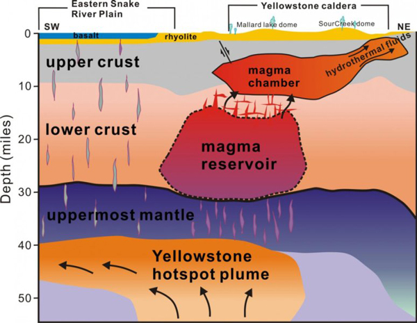
Cette coupe sud-ouest / nord-est sous Yellowstone a été obtenue grâce à l’imagerie sismique. (Source: University of Utah)

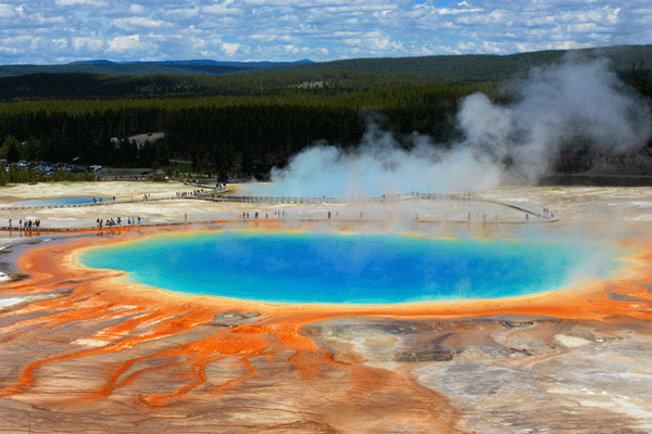
Un forage à Yellowstone, n’est-ce pas jouer avec le feu et risquer de saccager un site d’une beauté exceptionnelle? (Photo: C. Grandpey)


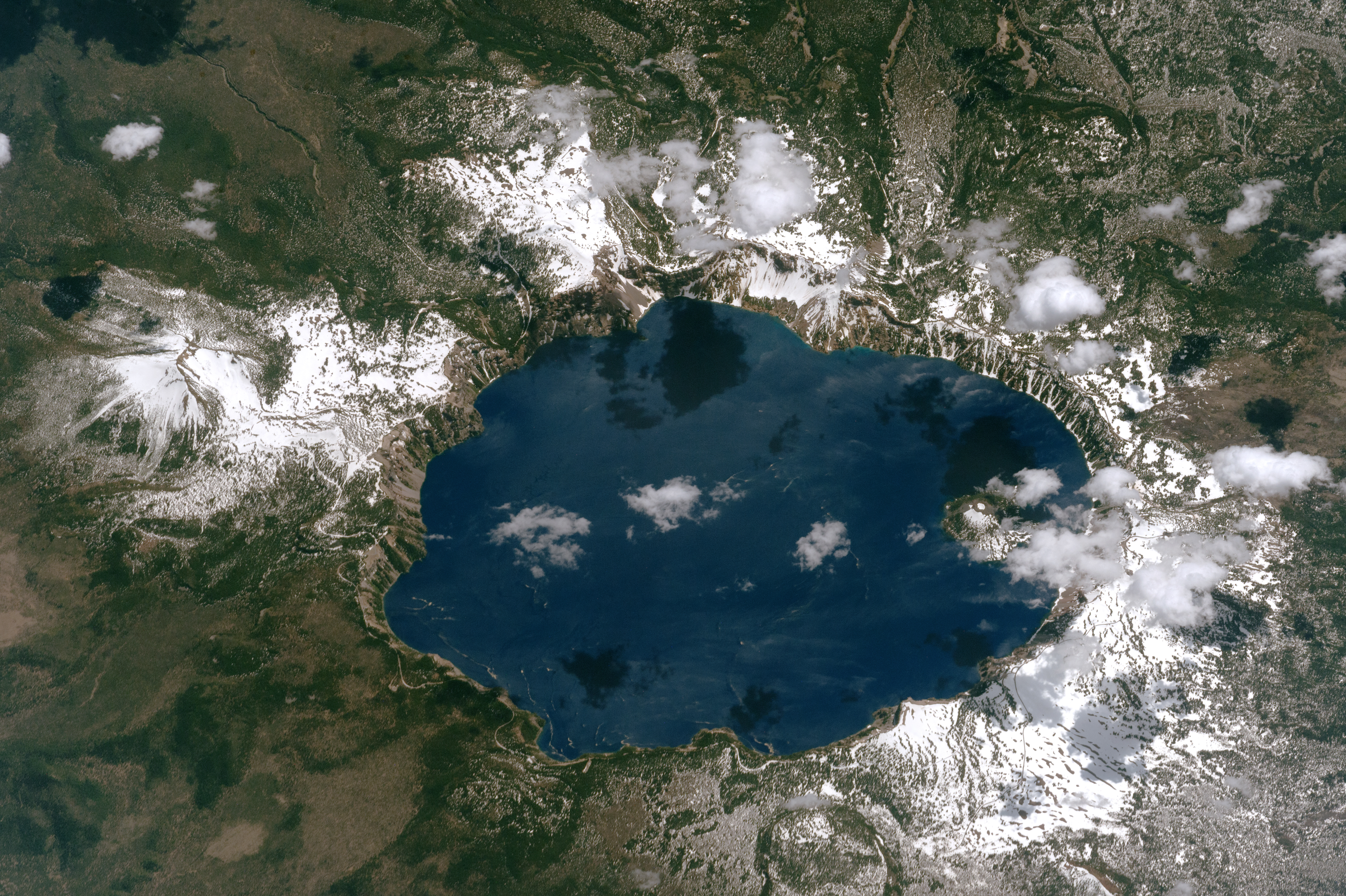
Belle image de Crater Lake (Etats Unis) // Nice photo of Crater Lake (United States)

La NASA vient de mettre en ligne une excellente image de Crater Lake prise par un astronaute à bord de la Station Spatiale Internationale le 26 juin 2017. Du point de vue technique, la photo a été réalisée avec un appareil photo numérique Nikon D4 équipé d’un objectif de 1150 millimètres
Crater lake se trouve dans la Chaîne des Cascades, dans le sud-ouest de l’Oregon. Il y a encore pas mal de neige dans le secteur de Crater Lake fin juin, et les nuages ​​jettent des ombres sombres sur la surface du lac. On distingue Wizard Island, un cône de cendre en partie caché par les nuages, dans la partie ouest du lac. (Le nord se trouve au bas de la photo.)
Crater Lake se trouve à l’intérieur d’une caldeira qui s’est formée lorsque le Mont Mazama, un volcan composite dont le sommet se dressait à 3 600 mètres, a explosé et s’est effondré lors d’une éruption cataclysmale il y a environ 6 000 ou 8 000 ans.

Le lac se trouve à une altitude de 1 883 mètres. Alimenté par la pluie et la neige, sans rivières qui y entrent ou qui en sortent, Crater (592 mètres de profondeur) est le plus profond aux États-Unis et le neuvième plus profond dans le monde.

En 1902, Crater Lake et les 740 kilomètres carrés qui l’entourent ont été érigés au rang deParc National. En 2016, plus de 750 000 personnes ont visité le parc.
Source : NASA.

Vous obtiendrez une image plus grande en cliquant sur ce lien:
https://eoimages.gsfc.nasa.gov/images/imagerecords/90000/90647/ISS052-E-8744_lrg.jpg

———————————————–

NASA has just released a great image of Crater Lake taken by an astronaut aboard the International Space Station on June 26th 2017. From a technical point of view, the photo was taken with a Nikon D4 digital camera using an 1150-millimetre lens

Crater Lake is located in the Cascade Mountains of southwest Oregon. Snow still blankets most of the slopes surrounding the crater in late June, and clouds cast dark shadows on the lake surface. Wizard Island is a cinder cone volcano almost hidden by the clouds over the western part of the lake. (Note that north is to the bottom of the photo.)

Crater Lake is the surface expression of a caldera that formed when Mount Mazama, a composite volcano whose peak once towered 3,600 metres, exploded and collapsed in a catastrophic eruption approximately 6,000 to 8,000 years ago. The lake now stands 1,883 metres above sea level.

Fed by rain and snow, and with no rivers flowing in or out, Crater Lake  (592 metres deep) is the deepest in the United States and ninth deepest in the world.

In 1902, Crater Lake and the surrounding 740 square kilometres were established as Crater Lake National Park. In 2016, more than 750,000 people visited the park.

Crédit photo: NASA

You will get a larger image by clicking on this link :

https://eoimages.gsfc.nasa.gov/images/imagerecords/90000/90647/ISS052-E-8744_lrg.jpg


Des nouveaux drones pour explorer les volcans // New drones to explore volcanoes

La NASA vient de signer avec Black Swift Technologies (BST), une entreprise d’ingénierie basée à Boulder (Colorado), un contrat pour la construction de drones capables d’explorer les volcans. Le projet permettra d’améliorer les systèmes de gestion du trafic aérien et la mesure des concentrations de cendre dans l’air.
BST construira des petits drones avec une structure et des capteurs adaptés à la mesure de la température, de la pression, de l’humidité, de la taille des particules de cendre et des gaz traces. Ils auront l’aspect d’avions à voilure fixe, avec une envergure d’environ 3 mètres.  Ils seront opérationnels dans les environnements difficiles, même par vents forts. Il faudra environ deux ans pour les concevoir ; le travail se fera dans le Colorado.
Les drones seront spécifiquement conçus pour transporter un équipement scientifique dans leur partie avant. Leur construction s’inspirera d’un autre projet déjà subventionné par la NASA et qui mesurait l’humidité du sol depuis le ciel. Les nouveaux drones devraient avoir une autonomie d’environ trois heures, avec une seule batterie.
À l’avenir, Black Swift prévoit d’adapter ses drones à d’autres fins de recherche, en partenariat avec l’Université du Colorado et la NOAA. Le but est d’utiliser le drone pour des processus commerciaux, tels que le suivi des cultures pendant leur développement.
Source: BizWest.

————————————-

NASA has awarded Black Swift Technologies, a specialized engineering firm in Boulder (Colorado), a contract to develop a drone platform to explore volcanoes. The research will be used to improve air-traffic-management systems and the accuracy of ashfall measurements.

BST will deliver small drones that include an airframe and sensors specific to measuring temperature, pressure, humidity, particle sizing and trace gases. They will be fixed-wing aircraft with a wingspan of about 3 metres. They will be able to work in harsh environments, even with strong winds. It will take about two years to design, build and test the aircraft, which will be done in Colorado.

The unmanned aerial system will be specifically designed to carry scientific equipment as its payload, loading it near the nose of the plane. The aircraft BST is using is actually a modification from another project they did under a NASA grant that measured soil moisture from the air. It should have a flight time of about three hours on a single battery.

Looking ahead, Black Swift has started adapting its aircraft for other research purposes, partnering with the University of Colorado and National Oceanic and Atmospheric Administration (NOAA). The plan eventually is to use the aircraft for commercial processes, such as monitoring crops during the grow season.

Source : BizWest.

Source: BST.