L’éruption du Hunga Tonga-Hunga Ha’apai : un record d’éclairs // A record of lightning strikes

L’éruption du volcan sous-marin Hunga Tonga-Hunga Ha’apai en 2022 appartient au monde des superlatifs et des records. Elle a généré la plus puissante explosion atmosphérique jamais enregistrée. Elle a également produit un nombre record d’éclairs au cours d’un orage électrique qui a duré 11 heures et s’est étendu sur 240 kilomètres.
Dans une note publiée le 26 janvier 2023, j’écrivais que pour étudier les éclairs qui ont accompagné l’éruption, les scientifiques ont utilisé les données de GLD360, un réseau de détection de la foudre au sol. Ces données ont révélé que, sur les quelque 590 000 éclairs détectés pendant l’éruption, environ 400 000 se sont produits dans les six heures qui ont suivi la puissante explosion du 15 janvier.
Avant l’éruption du Hunga Tonga-Hunga Ha’apai, le plus grand événement de foudre volcanique s’est produit en Indonésie en 2018, lorsque l’Anak Krakatau est entré en éruption et a généré environ 340 000 éclairs en une semaine. Environ 56 % des éclairs produits par l’éruption des Tonga ont frappé la terre ou la surface de l’océan, et plus de 1 300 impacts ont été enregistrés sur Tongatapu, l’île principale des Tonga.
Une nouvelle étude publiée le 19 juin 2023 dans la revue Geophysical Research Letters nous donne plus de détails sur cet aspect de l’éruption. Nous apprenons que l’orage électrique a eu lieu à une altitude sans précédent de 20 à 30 kilomètres.
L’imagerie satellite montre que les éclairs n’étaient pas répartis au hasard dans le panache éruptif, mais qu’ils se produisaient en plusieurs anneaux concentriques qui semblaient liés à chaque phase explosive du volcan. En s’élevant, le panache a pris la forme d’un pin parasol. Ce phénomène a imprimé au nuage un mouvement vertical si important que l’onde a couvert 10 kilomètres en verticalité. Cette onde de pression oscillante, également connue sous le nom d’onde de gravité, est à l’origine de la foudre.
Les éclairs ont pu se former de deux manières différentes au sein de cette onde de gravité en forme d’anneau. L’éruption du Hunga Tonga s’étant déroulée sous l’eau, elle a injecté beaucoup d’eau dans l’atmosphère terrestre et les cristaux de glace qui en ont résulté ont adopté des charges positives et négatives. En outre, une partie des cendres volcaniques, formées de roches fragmentées et de magma projetées dans l’air par l’éruption, ont également été ionisées, ce qui a donné naissance à de nouvelles zones de charge positive et négative.
Si des anneaux de foudre ont déjà été observés dans des panaches volcaniques, l’éruption du Hunga Tonga a été la première à montrer des anneaux multiples (on en a compté quatre) et la foudre a glissé sur les ondulations des anneaux, comme un surfeur sur les vagues de l’océan.

Les anneaux de foudre sont également appelés « trous de foudre », car à l’intérieur de l’anneau, il n’y a généralement pas d’éclairs. L’éruption du Hunga Tonga est toutefois différente : les trous ont commencé à se remplir d’éclairs dans les minutes qui ont suivi le passage de l’onde de gravité. Le mécanisme à l’origine de ce remplissage n’a pas encore été élucidé par les chercheurs.
Outre le fait de battre des records, l’éruption du Hunga Tonga est susceptible de nous renseigner sur le volcanisme sur la Terre primitive, voire sur d’autres corps célestes. L’éruption est de type phréatoplinien, autrement dit elle se produit lorsqu’une énorme quantité de roche en fusion jaillit à travers une épaisse couche d’eau.
L’éruption pourrait aider à comprendre comment la foudre se déclenche sur d’autres planètes, telles que Vénus, ou d’autres corps planétaires qui ne sont pas le cadre de la foudre traditionnelle.
Source : Space.com.

——————————————–

The 2022 Hunga Tonga-Hunga Ha’apai volcanic eruption belongs to the world of superlatives. It produced the most powerful atmospheric explosion ever recorded. It also generated a record number of lightning strikes in a thunderstorm that lasted 11 hours and spread across 240 kilometers.

In a post released on January 26th, 2023, I wrote that to study the lightning that accompanied the eruption, the scientists used data from GLD360, a ground-based lightning detection network. This data revealed that, of the approximately 590,000 lightning strikes detected during the eruption, around 400,000 occurred within six hours that followed the powerful January 15th explosion.
Prior to the Hunga Tonga-Hunga Ha’apai eruption, the largest volcanic lightning event occurred in Indonesia in 2018, when Anak Krakatau erupted and generated around 340,000 lightning strikes in a week. About 56% of the lightning produced by the Tonga eruption struck the land or ocean surface, and more than 1,300 strikes were recorded on Tongatapu, the main island of Tonga.

A new research published on June 19th, 2023 in the journal Geophysical Research Letters gives us more details about tat aspect of the eruption. We learn that the lightning storm took place at an unprecedented altitude of between 20 and 30 kilometers.

The satellite imagery shows that the lightning was not randomly spread across the plume but rather occurred in several concentric rings that seemed to be linked to each explosive outburst from the volcano. As the plume rose upward, it formed an « umbrella cloud. » This imparted a vertical motion into the cloud so huge that the wave, moving outward from the center of the plume, was 10 vertical kilometers from crest to trough. This oscillating pressure wave, also known as a gravity wave, was the source of the lightning.

There are two ways the lightning may have formed within this ring-shaped gravity wave. Since the Hunga Tonga eruption took place underwater, it injected lots of water into Earth’s atmosphere, the resulting ice crystals adopting positive and negative charges. In addition, some of the volcanic ash that was formed of fragmented rock and magma blown into the air by the eruption also become ionized, leading to more areas of positive and negative charge. It is the gradient in electrical charge that sets off sudden sparks of lightning.

While lightning rings have been seen in volcanic plumes before, the Hunga Tonga eruption was the first time multiple rings (four of them) had been seen and the lightning rode the rippling rings like a surfer on ocean waves.

Lightning rings are also termed « lightning holes, » because inside the ring there usually is no lightning. However, the Hunga Tonga eruption was different: because the holes started filling with lightning within minutes of the gravity wave rippling by. The mechanism that prompted this infilling remains unclear.

Besides breaking records in the present day, the Hunga Tonga eruption could also teach us about volcanism on the early Earth, and even potentially on other celestial bodies. The eruption is a type referred to as phreatoplinian. It occurs when a huge amount of molten rock erupts through a thick layer of water.

The eruption could also have implications for the way that lightning gets going on other planets, such as Venus, or other planetary bodies that do not support traditional lightning.

Source : Space.com.
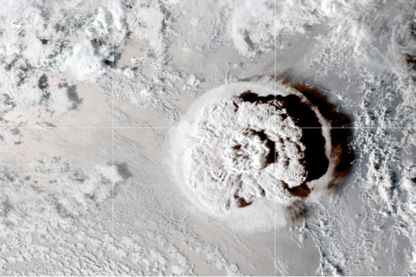
Source: NASA
L’éruption du Hunga Tonga-Hunga Ha’apai a perturbé l’ionosphère // The Hunga Tonga-Hunga Ha’apai eruption disturbed the ionosphere

L’éruption du Hunga Tonga-Hunga Ha’apai, le volcan sous-marin des Tonga, en janvier 2022, est exceptionnelle et représente un trésor pour les scientifiques qui ne cessent de faire de nouvelles découvertes.Ils ont déjà publié une analyse qui montre que cette éruption a généré le plus haut panache volcanique de tous les temps (57 km), avec pénétration de la stratopause, la limite supérieure de la stratosphère.
Aujourd’hui, une équipe internationale de chercheurs a découvert que l’éruption a perturbé les signaux satellites à grande échelle. Les scientifiques ont utilisé des observations ionosphériques satellitaires et terrestres pour montrer qu’une onde de pression atmosphérique déclenchée par une éruption volcanique est capable de produire une bulle de plasma équatoriale (EPB) dans l’ionosphère, avec de fortes perturbations causées aux communications par satellite. Les résultats de ces travaux ont été publiés dans la revue Scientific Reports.
L’ionosphère s’étend d’une altitude d’environ 80 à 1 000 km. C’est la région de la haute atmosphère terrestre où les molécules et les atomes sont ionisés par le rayonnement solaire, ce qui donne naissance à des ions chargés positivement. La zone avec la plus forte concentration de particules ionisées, la région F – 150 à 800 km de la surface de la Terre – joue un rôle crucial dans les communications radio longue distance car elle réfléchit et réfracte les ondes radio utilisées par les systèmes de suivi par satellite et GPS vers la surface de la Terre. Cependant, des trous peuvent se former dans cette région F, créant une structure en forme de bulle appelée EPB (Equatorial Plasma Bubble) qui peut retarder les ondes radio. et dégrader les performances du GPS.
L’équipe de chercheurs, qui comprenait principalement des scientifiques japonais collaborant avec diverses institutions, a utilisé le satellite Arase pour détecter les survenues d’EPB, le satellite Himawari-8 pour vérifier l’arrivée initiale des ondes de pression atmosphérique, et des observations ionosphériques au sol pour suivre les mouvements de l’ionosphère.
Ces scientifiques ont observé une structure irrégulière de la densité électronique au niveau de l’équateur après l’arrivée des ondes de pression générées par l’éruption volcanique. Ils ont également fait une découverte surprenante. Pour la première fois, ils ont montré que les fluctuations ionosphériques commencent quelques minutes à quelques heures plus tôt que les ondes de pression atmosphérique impliquées dans la génération des bulles de plasma. Cela signifie que le modèle du couplage géosphère-atmosphère-cosmosphère qui existait jusqu’à présent et qui stipulait que les perturbations ionosphériques ne se produisent qu’après l’éruption, doit être révisé.
De plus, les chercheurs ont constaté que l’EPB s’étend beaucoup plus loin que prévu par les modèles classiques. Cette découverte montre qu’il y a intérêt à prêter attention au lien entre l’ionosphère et la cosmosphère lorsque des phénomènes naturels extrêmes, tels que l’éruption du Hunga Tonga-Hunga Ha’apai, se produisent.
Les résultats de ces recherches présentent un intérêt du point de vue scientifique, mais aussi du point de vue de la météo spatiale et de la prévention des catastrophes.
Source : The Watchers, un excellent site qui publie des articles et des informations en relation avec la science et l’environnement.

——————————————-

The eruption of Hunga Tonga-Hunga Ha’apai, the underwater volcano in Tonga, in January 2022 was exceptional and a treasure for scientsists who keep making new discoveries. For instance, they have already an analysis that showed this eruption created the highest volcanic cloud ever recorded. For the first time, a volcanic plume has been seen to penetrate the stratopause, the upper limit of the stratosphere.

This time, an international team found that the eruption disrupted satellite signals. The researchers used both satellite and ground-based ionospheric observations to show that an air pressure wave triggered by the volcanic eruptions could produce an equatorial plasma bubble (EPB) in the ionosphere, severely disrupting satellite-based communications. The findings were published in the journal Scientific Reports.

The ionosphere is the region of the Earth’s upper atmosphere where molecules and atoms are ionized by solar radiation, creating positively charged ions. The area with the highest concentration of ionized particles, the F-region, plays a crucial role in long-distance radio communication, reflecting and refracting radio waves used by satellite and GPS tracking systems back to the Earth’s surface. However, irregularities in the F-region, such as the movement of plasma, electric fields, and neutral winds, can cause the formation of a localized irregularity of enhanced plasma density, creating a bubble-like structure called an EPB that can delay radio waves and degrade the performance of GPS.

The team, that mainly included Japanese scientists in collaboration with various institutions, used the Arase satellite to detect EPB occurrences, the Himawari-8 satellite to check the initial arrival of air pressure waves, and ground-based ionospheric observations to track the motion of the ionosphere.

They observed an irregular structure of the electron density across the equator that occurred after the arrival of pressure waves generated by the volcanic eruption.

The group also made a surprising discovery. For the first time, they showed that ionospheric fluctuations start a few minutes to a few hours earlier than the atmospheric pressure waves involved in the generation of plasma bubbles. This suggests that the long-held model of geosphere-atmosphere-cosmosphere coupling, which states that ionospheric disturbances only happen after the eruption, needs revision.

Furthermore, the researchers found that the EPB extended much further than predicted by the standard models. This discovery suggests that we should pay attention to the connection between the ionosphere and the cosmosphere when extreme natural phenomena, such as the Tonga event, occur.

The results of this research are significant not only from a scientific point of view but also from the point of view of space weather and disaster prevention.

Source : The Watchers, an excellent website that releases articles and information linked to science and the environment.

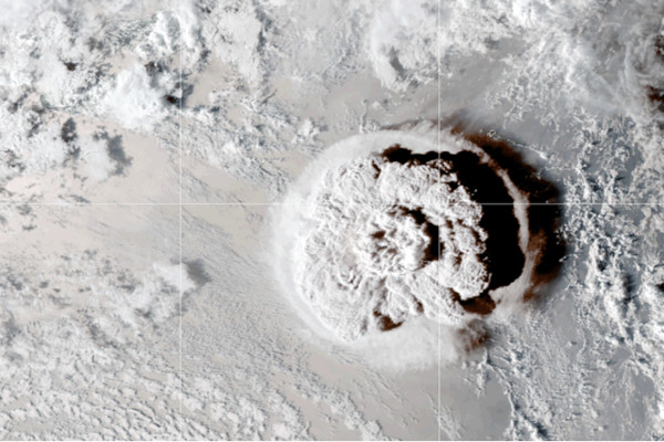
Hunga Tonga-Hunga Ha’apai, l’éruption de tous les superlatifs (Source: NASA)

Surveillance des volcans sous-marins // Monitoring of underwater volcanoes

Comme je l’ai écrit précédemment, l’éruption du 15 janvier 2022 du volcan sous-marin Hunga Tonga-Ha’apai a été exceptionnelle par sa puissance et son intensité. Aujourd’hui, les scientifiques réalisent qu’elle aura des répercussions pour les centaines de volcans sous-marins qui parsèment les océans de la Terre. Un volcanologue néo-zélandais a déclaré fort justement : « L’éruption du Hunga met en évidence un nouveau type de volcan et de nouvelles menaces sous la surface des océans. »
Très peu de volcans sous-marins font l’objet d’une surveillance digne de ce nom. Parmi eux figure l’Axial, à quelques centaines de kilomètres au large de la côte de l’Oregon et qui est étudié depuis les années 1970. Il ne faudrait pas oublier, non plus, le Kick ’em Jenny près de la Grenade. Ces deux volcans reçoivent régulièrement des missions scientifiques et sont dotés de capteurs qui surveillent leur activité
Le problème est que beaucoup d’autres volcans sous-marins sont situés loin de tout dans des arcs du Pacifique, loin des grandes villes ou des ports où les navires de recherche font escale. Leurs voisins les plus proches sont de petites nations insulaires, comme les Tonga, qui n’ont pas de programmes dédiés à la surveillance volcanique ou sismique. Cela est dû en partie à des problèmes géographiques. Les Tonga, par exemple, sont un alignement d’îles, ce qui n’est pas l’idéal pour trianguler les sources d’ondes sismiques. De plus, le personnel et l’argent font défaut dans ces pays où la population a la taille de celle d’une grande ville américaine. Il existe des solutions à l’échelle internationale, comme le réseau de surveillance sismique de l’USGS, qui offrent une couverture globale et permettent de détecter une activité géologique inhabituelle, mais ces stations sont trop peu nombreuses pour capter l’activité discrète qui précède une éruption sous-marine.
La plupart de ces éruptions n’atteindront jamais la puissance de celle du Hunga Tonga-Hunga Ha’apai, mais l’événement a attiré l’attention sur l’activité de ces volcans. Même si les éruptions du volcan tongien ne se produisent pas souvent, elles ne doivent pas être laissées de côté.
L’éruption du Hunga Tonga-Hunga Ha’apai a mis en jeu un processus exceptionnellement explosif qui a peu de chance de se reproduire ailleurs. Pendant environ un mois, l’éruption a progressé comme on pouvait s’y attendre. Elle a été d’intensité moyenne, avec des gaz et des cendres. Puis tout a basculé. Les volcanologues pensent que ce changement soudain est le résultat d’au moins deux facteurs. D’une part, il y a eu, en profondeur sous le volcan,le mélange de sources magmatiques de composition chimique légèrement différente. Au fur et à mesure de leur interaction, elles ont produit des gaz qui ont fait augmenter le volume du magma dans son encaissant. Sous cette pression énorme, les roches au-dessus ont commencé à se fracturer, ce qui a permis à l’eau de mer de s’infiltrer. Il s’en est suivi une double explosion très violente qui a expédié d’énormes quantités de matériaux à travers le plancher de la caldeira.
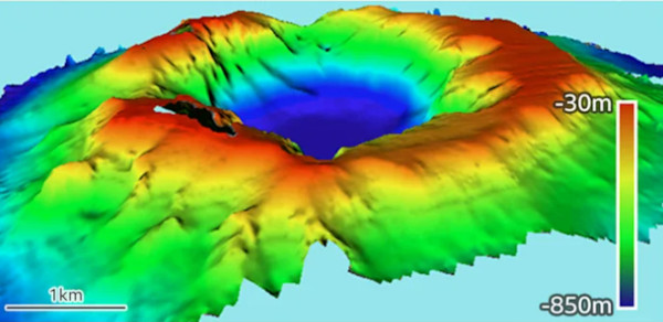
Les deux explosions ont généré de puissants tsunamis. La plus grosse vague est venue plus tard, probablement déclenchée par l’arrivée brutale d’eau dans la cavité d’un kilomètre de profondeur qui s’était soudainement creusée dans le plancher océanique. Ce phénomène a surpris les volcanologues. C’est un nouveau type de menace qui devra être pris en compte sur les autres volcans sous-marins. Auparavant, les scientifiques pensaient que ce type de volcan ne pouvait produire un puissant tsunami que si un côté d’une caldeira s’effondrait.
L’éruption du Hunga Tonga-Hunga Ha’apai a mis en évidence l’importance et la difficulté de l’étude des volcans sous-marins. Une expédition de cartographie classique implique un grand navire de recherche avec équipage complet, ainsi qu’un sonar multifaisceaux qui cartographie les changements intervenus sur les fonds marins, sans oublier une batterie d’instruments d’échantillonnage d’eau susceptibles de détecter les signes chimiques d’une activité en cours. De plus, placer un bateau au-dessus d’une caldeira potentiellement active présente des risques, pas tellement parce que le volcan peut entrer en éruption, mais parce que les bulles de gaz émises pourraient faire couler un navire.
Les Tonga, qui ont reçu quatre visites scientifiques au cours de l’année écoulée, ne devraient pas recevoir une autre grande mission au cours des prochaines années. Le coût est trop élevé. Il faudra probablement des décennies avant que chaque volcan sous-marin soit surveillé étroitement, même ceux de l’arc des Tonga. C’est dommage car ces expéditions sont l’un des rares moyens dont disposent les scientifiques pour comprendre réellement comment se comportent ces volcans.
Sans de telles expéditions, les scientifiques sont contraints de surveiller les volcans sous-marins à distance. Heureusement, les satellites peuvent repérer les bancs de pierre ponce ainsi que les proliférations d’algues qui sont nourries par les minéraux émis par les volcans. En outre, l’USGS, ainsi que ses homologues australiens, sont en train d’installer autour des Tonga un réseau de capteurs qui peuvent mieux détecter l’activité volcanique. On a une combinaison de stations sismiques avec des capteurs sonores et des webcams qui surveillent les explosions. S’assurer que ce système de surveillance reste opérationnel est un autre défi.
Source : Yahoo Actualités.

———————————————-

As I put it before, the January 15, 2022 eruption of Hunga Tonga-Ha’apai submarine volcano was exceptional for its power and intensity. Today, scientists realize it has implications for the hundreds of underwater volcanoes dotting the Earth’s oceans. A New Zealand volcanologist aptly said : “The Hunga eruption highlights a new type of volcano, and new types of underwater threats.”

Only a handful of underwater volcanoes have been the site of extensive research. Those include the Axial seamount, which lies a few hundred kilometers off the coast of Oregon and has been studied since the 1970s. One should not forget either Kick ’em Jenny near the Caribbean nation of Grenada. Both receive regular visits from research cruises and are covered with sensors that monitor their activity

The problem is that many more submarine volcanoes are located in remote arcs of the Pacific, far from big cities or ports where research vessels make harbour. Their closest neighbours are small island nations, like Tonga, that do not have dedicated volcano-monitoring programs or much capacity to install seismic monitors. This is in part due to geographical problems. Tonga, for example, is a line of islands, which is not ideal for triangulating the sources of seismic waves. Moreover, staffing and funds can be scarce in countries where the population is similar in size to a large US town. There are international options, like the USGS’ Seismic Monitoring Network, that offer global coverage for unusual geologic activity, but the stations are generally too few and far between to pick up the discreet activity foretelling a coming undersea eruption.

Most of those eruptions are unlikely to match the explosiveness of Hunga Tonga-Hunga Ha’apai, but the event awakened the world to the possibile activity of these volcanoes. Even though eruptiond loke the o,e at the Tongan volcano do not occur often, they should not be neglected.

Hunga Tonga-Hunga Ha’apai involved an unusually explosive process that may not be easily replicated. For about a month, the eruption progressed as expected. It was moderately violent, with gas and ash, but was still manageable. Then everything went sideways. Volcanologists think it was the result of at least two factors, One was the mixing of sources of magma with slightly different chemical compositions deep beneath the volcano. As these interacted, they produced gasses, expanding the volume of the magma within the confines of the rock. Under tremendous pressure, the rocks above began to crack, allowing the cold seawater to seep in. A double massive explosion ensued which blew huge quantities of material out through the top of the caldera.

Both explosions produced big tsunamis. But the biggest wave came later, potentially caused by water flooding into the kilometer-deep hole suddenly dug out of the seafloor. This phenomenon came as a surprise to volcanologists. It isa new type of threat that should be taken into account elsewhere. Previously, scientists thought that this kind of volcano could only really produce a big tsunami if a side of a caldera collapsed.

But the process of understanding the eruption of the Tongan volcano has also highlighted the challenges of studying submarine volcanoes. A typical mapping expedition will involve a large, fully crewed research vessel, equipped with multibeam sonar that maps the seafloor for changes and a battery of water sampling instruments that search for chemical signs of ongoing activity. However, taking a boat over a potentially active caldera is risky, not so much because the volcano might erupt, but because the gas bubbles burbling up might cause a ship to sink.

Even Tonga, which has been visited four times in the past year is not likely to get another big crewed mission in the next few years. The cost is just so high. It would likely take decades to survey every volcano in detail, even just those in the Tongan arc. This is a pity because those expeditions are one of the few ways scientists have to actually see how volcanoes are behaving.

Without such expeditions, scientists have to monitor submarine volcanoes from a distance. Fortunately, satellites can spot pumice rafts as well as algal blooms, which are nurtured by the minerals released by volcanoes. Besides, the USGS, as well as counterparts in Australia, are in the process of installing a network of sensors around Tonga that can better detect volcanic activity, combining seismic stations with sound sensors and webcams that watch for active explosions. Ensuring it stays up and running is another challenge.

Source : Yahoo News.

Source: University of Auckland

Hunga Tonga-Hunga Ha’apai : l’éruption de tous les records (2ème partie)  // The eruption of all records (part 2)

L’éruption du 15 janviers 2022.

Une puissante éruption a de nouveau eu lieu sur le volcan Hunga Tonga-Hunga Ha’apai le 15 janvier 2022. Le panache de cendre et de gaz s’est élevé à environ 16,7 km au-dessus du niveau de la mer, selon le VAAC de Wellington. Il s’est étendu de manière concentrique sur une distance d’environ 130 km par rapport au volcan, créant un panache de 260 km de diamètre. Selon le service géologique des Tonga, l’éruption a duré plus de 12 heures. C’est la plus importante observée depuis décembre 2021.

Source: Tonga Services

Tsunami.

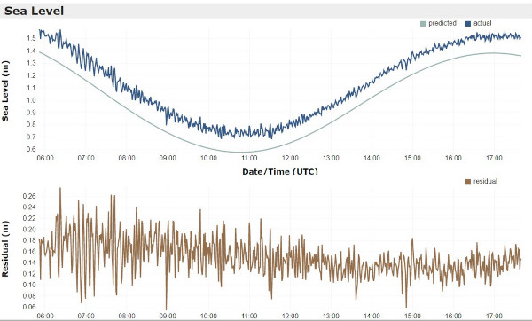
Des vagues de tsunami de 83 cm ont été observées par des jauges à Nuku’alofa et des vagues de 60 cm ont été enregistrées à Pago Pago, la capitale des Samoa américaines. Une alerte tsunami a été émise pour toutes les îles des Tonga; il a été conseillé aux habitants de s’éloigner de la côte. Le tsunami a détruit des villages et coupé les communications dans l’archipel des Tonga et ses 105 000 habitants. Trois personnes ont été tuées. Ce bilan est faible car la population est bien préparée pour faire face à un tsunami. Les habitants sont même probablement parmi les mieux préparés pour affronter les catastrophes naturelles, avec des années d’exercices tsunami: C’est pourquoi de nombreuses personnes ont su se réfugier sur des endroits plus élevés.

La vague de tsunami a provoqué une marée noire au Pérou lorsqu’un pétrolier battant pavillon italien a déversé 6 000 barils de pétrole dans l’océan Pacifique, près de la raffinerie de La Pampilla dans la banlieue de Lima. Le pétrolier déchargeait sa cargaison à La Pampilla lorsque la connexion entre le navire et le terminal s’est rompue.

Une particularité de la vague de tsunami est sa hauteur. D’après une étude récente publiée dans la revue Ocean Engineering, elle aurait atteint une hauteur de 90 mètres à son point de départ, soit environ neuf fois la hauteur du tsunami qui a frappé les côtes du Japon le 11 mars 2011, avec à la clé la catastrophe à la centrale nucléaire de Fukushima. Un autre puissant tsunami a également frappé le Chili en 1960. Que ce soit au Japon ou au Chili, la hauteur initiale de la vague a été estimée à une dizaine de mètres, autrement dit rien en comparaison de celle générée lors de l’éruption du Hunga Tonga-Hunga Ha’apai.

Les tsunamis de 2011 et 1960 ont pourtant été bien plus dévastateurs et meurtriers. Plus de 18.000 personnes ont péri en 2011, alors que le tsunami du Hunga Tonga n’a causé la disparition que de quelques personnes. Les scientifiques prennent en compte plusieurs paramètres pour expliquer cette différence de bilan. Il y a la distance entre la source du tsunami et les terres, la morphologie du plancher océanique et du littoral, mais également d’autres facteurs, comme la fusion de plusieurs vagues, comme cela semble s’être produit en 2011. À l’approche des côtes, une vague de tsunami peut ainsi être soit être atténuée, ou bien amplifiée. Le volcan Hunga Tonga est situé à environ 70 kilomètres des îles Tonga. C’est probablement cette distance qui a permis d’éviter le pire.

Source : USGS

Onde de choc.

L’onde de choc générée par l’éruption a parcouru plusieurs milliers de kilomètres, a été observée depuis l’espace et enregistrée en Nouvelle-Zélande à environ 2000 km. Elle s’est déplacée à plus de 300 mètres par seconde et était si puissante qu’elle a fait résonner l’atmosphère comme le fait une cloche. C’est l’onde de choc la plus puissante depuis l’éruption du Krakatau (Indonésie) en 1883. Grâce au transfert de cette énergie de l’atmosphère vers l’océan, l’onde de choc a amplifié les vagues océaniques dans le monde entier, les a repoussées plus loin et a accéléré leur vitesse de déplacement, un phénomène pour lequel les centres d’alerte aux tsunamis se sont pas équipés. Les modèles de prévision et les systèmes d’alerte, conçus principalement pour évaluer les vagues déclenchées par les séismes conventionnels, ont été déconcertés par l’événement des Tonga et ont donc commis des erreurs.

Effets de l’éruption Source : NASA

Perturbations atmosphériques.

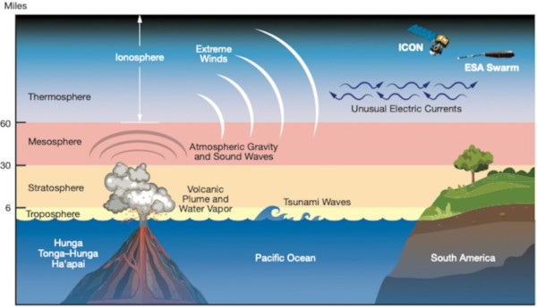
Plusieurs études ont indiqué que l’éruption du volcan Hunga Tonga-Hunga Ha’apai a provoqué des perturbations à grande échelle dans l’atmosphère terrestre. En utilisant les données enregistrées par plus de 5 000 récepteurs GNSS – Global Navigation Satellite System – situés à travers le monde, les scientifiques de l’Observatoire Haystack du Massachusetts Institute of Technology (MIT) et leurs collègues de l’Université arctique de Norvège ont observé des preuves d’ondes atmosphériques générées par les éruptions et de leurs empreintes ionosphériques à 300 kilomètres au-dessus de la surface de la Terre, et cela pendant une longue période. Ces ondes atmosphériques ont été actives pendant au moins quatre jours après l’éruption et ont fait trois fois le tour du globe. Les perturbations ionosphériques sont passées au-dessus des États-Unis six fois, d’abord d’ouest en est, puis en sens inverse. Cette éruption a été extraordinairement puissante et a libéré une énergie équivalente à 1 000 bombes atomiques de Hiroshima.
Une autre étude, menée par des chercheurs du MIT Haystack Observatory et de l’Arctic University of Norway, a été publiée le 23 mars 2022 dans la revue Frontiers in Astronomy and Space Sciences. Les auteurs pensent que les perturbations atmosphériques sont un effet des ondes de Lamb ; ces ondes, ainsi appelées d’après le mathématicien Horace Lamb, se déplacent à la vitesse du son sans grande réduction de leur amplitude. Bien qu’elles soient principalement situées près de la surface de la Terre, ces ondes peuvent échanger de l’énergie avec l’ionosphère de manière complexe. La nouvelle étude précise que « la présence dominante des ondes de Lamb a déjà été signalée lors de l’éruption du Krakatau en 1883 et à d’autres occasions. L’étude fournit pour la première fois une preuve substantielle de leurs empreintes de longue durée dans l’ionosphère à l’échelle de la planète. »

—————————————

The eruption of January 15, 2022.
A powerful eruption took place again on the Hunga Tonga-Hunga Ha’apai volcano on January 15th, 2022. The plume of ash and gas rose about 16.7 km above sea level, according to the Wellington VAAC. It extended concentrically over a distance of about 130 km from the volcano, creating a plume 260 km in diameter. According to the Tonga Geological Survey, the eruption lasted more than 12 hours. This was the largest eruption since December 2021.

A tsunami.
Tsunami waves of 83 cm were observed by gauges in Nuku’alofa and waves of 60 cm were recorded in Pago Pago, the capital of American Samoa. A tsunami warning was issued for all islands in Tonga; locals were advised to move away from the coast. The tsunami destroyed villages and cut communications in the Tonga archipelago and its 105,000 inhabitants. Three people were killed. This death toll is low because the population is well prepared to face a tsunami. The inhabitants are even probably among the best prepared to face natural disasters, with years of tsunami exercises: This is why many people knew how to take refuge on higher places.
The tsunami wave caused an oil spill in Peru when an Italian-flagged tanker spilled 6,000 barrels of oil into the Pacific Ocean near the La Pampilla refinery on the outskirts of Lima. The tanker was unloading its cargo at La Pampilla when the connection between the ship and the terminal broke.
A peculiarity of the tsunami wave was its height. According to a recent study published in the journal Ocean Engineering, it probably reached a height of 90 meters at its starting point, approximately nine times the height of the tsunami which hit the coasts of Japan on March 11th, 2011, with the disaster at the Fukushima nuclear plant. Another powerful tsunami also hit Chile in 1960. Whether in Japan or Chile, the initial height of the wave was estimated at ten meters, in other words nothing compared to that generated during the eruption of the Hunga Tonga-Hunga Ha’apai.
The 2011 and 1960 tsunamis, however, were far more devastating and deadly. More than 18,000 people died in 2011, while the Hunga Tonga tsunami caused the deaths of only a few people. Scientists take into account several parameters to explain this difference. There is the distance between the source of the tsunami and the land, the morphology of the ocean floor and the coastline, but also other factors, such as the merger of several waves, as seems to have happened in 2011. Approaching the coast, a tsunami wave can thus either be attenuated or amplified. The Hunga Tonga volcano is located about 70 kilometers from the Tonga Islands. It is probably this distance that made it possible to avoid the worst.

A shock wave.
The shock wave generated by the eruption traveled several thousand kilometres, was observed from space and recorded in New Zealand around 2000 km away. It moved at over 300 meters per second and was so powerful that it rang the atmosphere like a bell. It was the most powerful shock wave since the eruption of Krakatau (Indonesia) in 1883. Thanks to the transfer of this energy from the atmosphere to the ocean, the shock wave amplified the ocean waves in the world, pushed them further and accelerated their speed, a phenomenon for which the tsunami warning centers are not equipped. Prediction models and warning systems, designed primarily to assess waves triggered by conventional earthquakes, were confused by the Tonga event and therefore made mistakes.

Atmospheric disturbances.
Several studies have indicated that the eruption of the Hunga Tonga-Hunga Ha’apai volcano caused large-scale disturbances in the Earth’s atmosphere. Using data recorded by more than 5,000 GNSS – Global Navigation Satellite System – receivers located around the world, scientists from the Haystack Observatory at the Massachusetts Institute of Technology (MIT) and their colleagues from the Arctic University of Norway have observed evidence of atmospheric waves generated by eruptions and their ionospheric footprints 300 kilometers above the Earth’s surface, and this for a long time. These atmospheric waves were active for at least four days after the eruption and circled the globe three times. Ionospheric disturbances passed over the United States six times, first from west to east, then in the opposite direction. This eruption was extraordinarily powerful and released energy equivalent to 1,000 Hiroshima atomic bombs.
Another study, conducted by researchers at MIT Haystack Observatory and the Arctic University of Norway, was published on March 23rd, 2022 in the journal Frontiers in Astronomy and Space Sciences. The authors believe that atmospheric disturbances are an effect of Lamb waves; these waves, so called after the mathematician Horace Lamb, travel at the speed of sound without much reduction in their amplitude. Although mostly located near the Earth’s surface, these waves can exchange energy with the ionosphere in complex ways. The new study states that « the dominant presence of Lamb waves was already reported during the eruption of Krakatau in 1883 and on other occasions. The study provides for the first time substantial evidence of their long-lasting footprints in the ionosphere on a planetary scale. »