 Comme je l’ai expliqué à plusieurs reprises, tant que les éruptions ont lieu dans des zones désertiques, l’importance de la prévision volcanique est relative. Mais lorsque de la lave menace de percer la surface à proximité d’infrastructures essentielles ou de zones habitées, il est intéressant de savoir comment va se comporter un volcan. Les derniers événements survenus sur la péninsule islandaise de Reykjanes en sont la preuve. Une centrale électrique et un port de pêche sont menacés par des séismes et des coulées de lave.
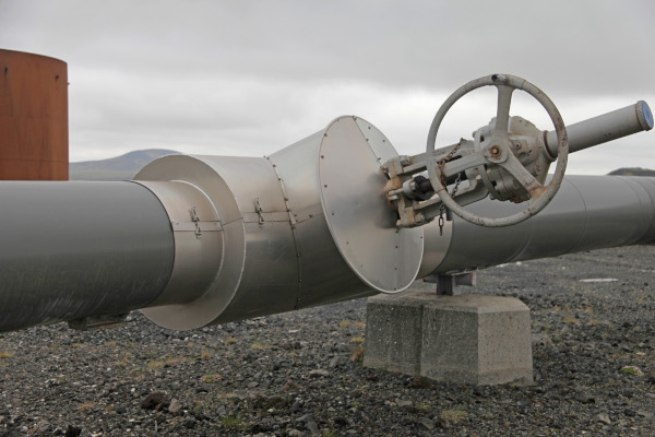
La centrale de Svartsengi alimente en électricité et en eau chaude quelque 30 000 habitants (Photo: C. Grandpey)
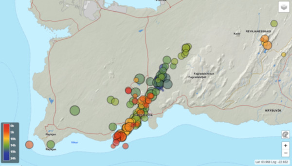
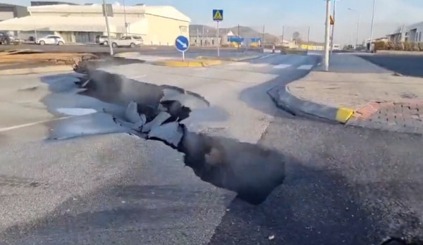
Grindavik (3 700 habitants) a été évacuée le 10 novembre 2023 car la sismicité était très forte et des fractures s’étaient ouvertes jusque dans la ville, avec le risque de voir de la lave sortir de ces fissures.
Une évacuation est toujours une situation très difficile. Il faut aller vivre ailleurs et parfois laisser derrière soi l’endroit où on est né et où on a passé toute sa vie. On peut lire sur le site Iceland Monitor le témoignage d’un couple qui a été contraint de quitter sa maison à Grindavik. L’homme et son épouse racontent les événements des dernières semaines et essayent d’envisager l’avenir.
Le couple vit depuis 35 ans à Grindavik, où le mari est né et travaille comme pêcheur. Le 10 novembre 2023 est une date qui restera à jamais gravée dans la mémoire des habitants de Grindavík. La sismicité était très forte, avec des secousses particulièrement violentes. La fille cadette du couple participait à un entraînement sportif qui a dû être annulé car tout tremblait. La jeune femme raconte aujourd’hui qu’en voiture elle avait « l’impression de rouler sur des vagues ! Devant moi, il y avait une voiture qui avançait à 30 kilomètres heure; je pensais qu’il s’agissait d’étrangers qui avançaient très lentement, mais ensuite une partie de la chaussée s’est ouverte devant leur voiture. Je suis arrivée en ville avant la fermeture de la route qui a été coupée en deux. »
Crédit photo: Protection Civile islandaise
Le soir du 10 novembre, tous les habitants de Grindavík reçurent l’ordre d’évacuer la ville. Le couple pense que c’était la bonne décision. Ils avaient l’impression que la terre pouvait littéralement les engloutir.
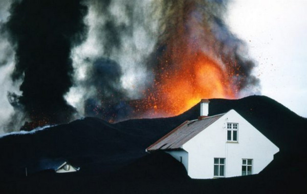
La dernière éruption a commencé le 14 janvier, 2024. La femme a déclaré : « Nous nous attendions à cet événement et maintenant nous attendons toujours que quelque chose d’autre se produise. Il y a toujours cette attente et cette incertitude. » L’éruption s’est produite juste au nord des digues de protection et un peu à l’intérieur de celles-ci, mais elles ont tout de même montré leur efficacité. Autrement, la lave aurait recouvert des zones beaucoup plus vastes de la ville.
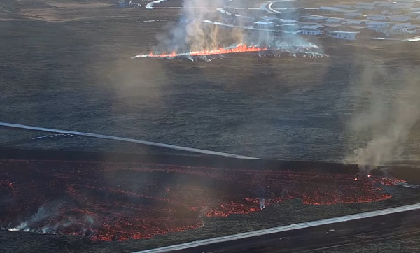
La lave est partiellement retenue par les digues de terre (image webcam)
Le couple vit désormais dans un appartement au sous-sol d’une maison à Arnarnes, gracieusement prêté par des amis. Ils ne savent pas s’ils rentreront un jour chez eux, à Grindavík, même si l’espoir est toujours là. Leur avenir est incertain, comme celui des autres habitants du petit port de pêche. Ils sont reconnaissants d’avoir pu obtenir ce petit appartement et que toute leur famille soit en sécurité. La catastrophe a également eu des conséquences psychologiques. Parfois, les gens ont des crises de déprime et d’angoisse. « Certains jours, on se sent lourd et impuissant. Il y a toute cette incertitude. On ne sait rien ! » Le couple se demande où il a envie de vivre. Une chose est sure: ils ne retourneront pas à Grindavík dans un avenir proche. Ils espèrent pouvoir rentrer chez eux un jour, mais pas avant plusieurs années.
Source : Iceland Monitor.
Dernière minute : le 29 janvier 2024, les autorités ont autorisé les habitants de Grindavík à entrer dans la ville et à récupérer certaines de leurs affaires. Ils ont été autorisés à rentrer en petits groupes et ont disposé de trois heures pour récupérer leurs biens les plus importants. Des règles strictes étaient imposées lors de leur visite. Par exemple, ils n’étaient pas autorisés à régler le chauffage de leur maison, à utiliser les salles de bain ou à se déplacer dans la ville. Il y a toujours de nombreuses crevasses béantes et des infrastructures restent endommagées.
Source : Iceland Review..
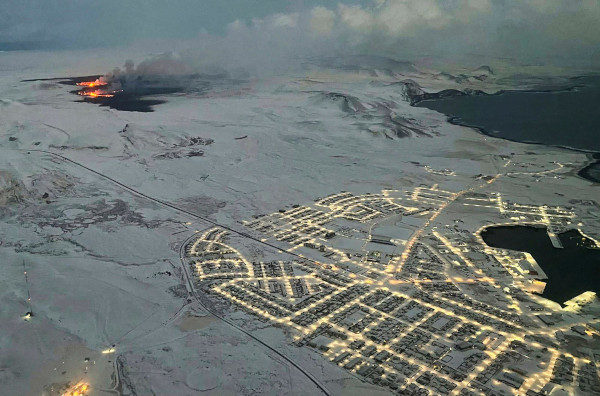
Grindavil reste sous la menace de la lave (Crédit photo: Iceland Review)
°°°°°°°°°°
A lire aussi à propos de cette éruption :
—————————————————
 As I have explained several times before, as long as eruptions take place in desert areas, the importance of volcanic predition is limited. But when lava emerges close to infrastructure or residential areas, it is essential to know how a volcano will behave. The latest events on the Icelandic Reykjanes peninsulaare the proff of this. Both a power station and a fishing port are under the threat of earthquakes and lava flows.
Grindavik (pop. 3,700) was evacuated on Nevember 10th, 2023 because seismicity was elevated and fissures were opening right into the town, with the risk of seeing lava emerge from the cracks.
An evacuation is always a very difficult situation for the people who have to go and live somewhere else, and sometimes leave behind them the place where they were born or had spent all their life. We can read on the website Iceland Monitor the testimony of couple who was forced to leave their house in the small fishing port. They recount the events of the last few weeks and predict the future.
The couple have lived for 35 years in Grindavik where the husband was born and has been worhing as a fisherman. November 10th, 2023 is a date that will forever be carved into the memory of residents of Grindavík. Seismicity was very high and the ground was shaking. The couple’s youngest daughter was participating in a sport’s training session which had to be cancelled because everything was shaking. The young woman reports today that “the road was just rolling up in waves! A few cars before me was a car travelling at 30 kilometres, and I thought there were some foreigners moving very slow, but then the tarmac opened on the road in front of them. I just got into town before the road was closed.”
On the evening of November 10th, all the residents of Grindavík were then ordered to evacuate the town. The couple say it was the right decision. They felt as if the earth could literally swallow them.
The last eruption began on January 14th, 2024. The woman said : “We had been waiting for this to happen and now we are still waiting for something more to happen. There’s always this wait and uncertainty.” The eruption occurred just north of the defense walls and a little bit inside them, but the walls still proved their value. Otherwise, lava would have covered much larger parts of the town.
The couple now live in a basement apartment in Arnarnes, which an acquaintance graciously lent to them. They don’t know if they will ever go back home to Grindavík, even though hope is still there. Their future is uncertain, as for other residents of Grindavík. They are grateful that they have been able to get a small apartment and that all their family is safe. The disaster has taken on a mental toll. Sometimes people are overwhelmed with depression and anxiety. “Some days you’re quite heavy. There’s all this uncertainty. You don’t know anything!” The couple are now trying to figure out wherethey want to live. However, they are both sure that they are not going to Grindavík in the near future. They hope they will be able to return home someday, but not in the next few years.
Source : Iceland Monitor.
Last minute : on January 29th, 2024, authorities gave permission for Grindavík residents to enter the town and pick up some of their belongings. Residents were allowed re-entry in groups and had three hours to collect their most important possessions, They had to follow strict rules during their visit. For instance, they were not allowed to adjust the heating in their homes, use bathrooms, or move around the town. Many open crevasses remain across the area and infrastructure is damaged.
Source : Iceland Review.