 Des enseignements peuvent – et doivent – être tirés de la dernière éruption sur la péninsule de Reykjanes (18-21 décembre 2023). Cet événement a montré les limites de la prévision volcanique et a rappelé à l’humilité devant les phénomènes naturels. Il faut le dire franchement : nous nous sommes tous plantés, volcanologues et volcanophiles compris !
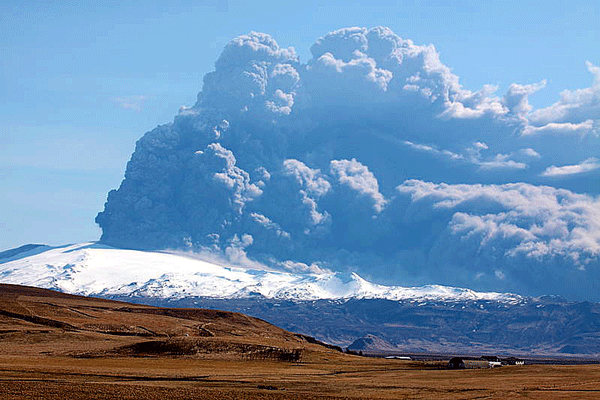
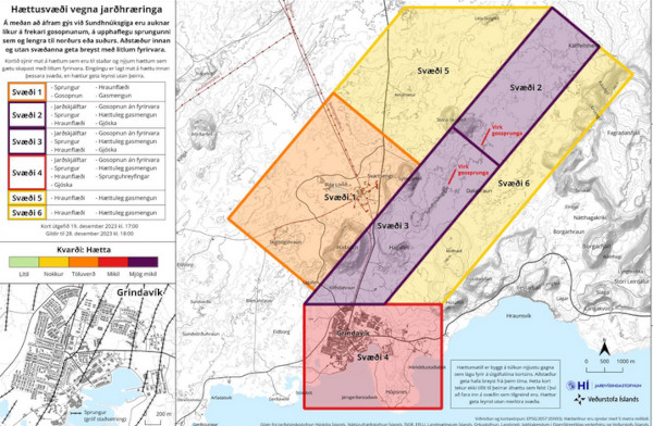
S’agissant des points positifs, les instruments (sismomètres, inclinomètres ) ont bien détecté l’arrivée d’une intrusion magmatique sur la péninsule. Sa progression a pu être suivie avec précision, ainsi que les événements qui l’ont accompagnée : soulèvement du sol dans le secteur de Svartsengi et ouverture de fissures vers Grindavik.
Le point négatif se situe au niveau de la prévision éruptive. Dès l’apparition de l’intrusion magmatique et de la déformation du sol entre le 20 et le 23 octobre 2023, les volcanologues islandais ont annoncé une éruption ‘imminente’. Ne la voyant pas venir au bout de plusieurs jours, l’imminence s’est transformée en probabilité. Ensuite, vers le 15 décembre, au vu de la très faible sismicité, l’état d’urgence a été levé. Le Blue Lagoon a rouvert le 17 décembre et on a envisagé le retour des habitants évacués de Grindavik à leur domicile pour Noël.
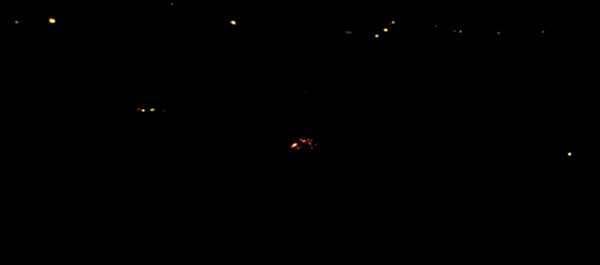
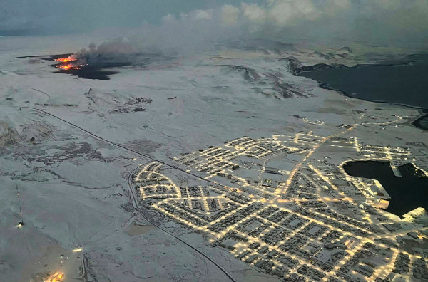
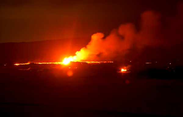
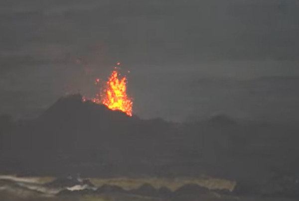
La 18 décembre, patatras ! Rapide crise sismique et rapide sortie de la lave surprenant tout le monde ! Ouverture d’une fracture dans le secteur de Sundhnúkagígar avec un beau rideau de fontaines de lave au bout de quelques minutes. Un volcanologue français a indiqué sur France Info que « ce pourrait être la plus grosse éruption connue sur l’île depuis 2021 ». En effet, au cours des sept premières heures, l’éruption a émis plus de lave que l’éruption de trois semaines du Litli-Hrutur il y a quelques mois. On a craint que ce nouveau magma emprunte la fissure existante pour aller noyer Grindavik sous la lave. Par chance, ces craintes sont restées infondées. Le rideau de fontaines de lave initial a vite été remplacé par cinq bouches actives, puis trois, puis une seule le long de la fracture éruptive. Aucune activité n’était visible le 21 décembre au matin, hormis quelques points d’incandescence sur le champ de lave. Les prévisions les plus pessimistes tombaient à l’eau.
Comme je l’avais indiqué avant le début de l’éruption – une personne l’a sciemment oublié pour pouvoir me critiquer – il fallait rester vigilant malgré la faible sismicité. On n’était pas à l’abri d’un nouvel afflux de magma et il n’est pas exclu aujourd’hui que cette situation se reproduise dans les prochaines heures ou les prochains jours. A moins qu’il s’agisse juste de l’évacuation d’une poche résiduelle de magma ? L’expérience m’a montré que les volcans effusifs de point chaud – le Piton de la Fournaise, par exemple, sur l’île de la Réunion – pouvaient nous réserver de telles surprises, avec des réveils intempestifs.
Espérons que tout se passera bien et que les Islandais pourront passer un Noël tranquille.
En tout cas, ceux qui comptaient acheter un billet d’avion pour aller en Islande admirer l’éruption avaient sacrément intérêt à se dépêcher. J’étais très tenté, mais j’avais un empêchement à la maison. Heureusement!

Retour au calme le 21 décembre au matin… (Capture écran webcam)
———————————————–
 Lessons should be learned from the latest eruption on the Reykjanes Peninsula (December 18-21, 2023). This event showed the limits of volcanic prediction and reminded us to be humble in the face of natural phenomena. We have to admit all, volcanologists and volcanophiles, that we failed with our predictions !
Regarding the positive points, the instruments (seismometers, tiltmeters) detected the arrival of a magma intrusion on the peninsula. Its progression could be precisely followed, as well as the events which accompanied it: ground uplift in the Svartsengi sector and opening of fissures towards Grindavik.
The negative point lies in the eruptive prediction. As soon as the magma intrusion and ground deformation appeared between October 20th and 23rd, 2023, Icelandic volcanologists announced an ‘imminent’ eruption. Not seeing it coming after several days, the imminence turned into probability. Then, around December 15th, in view of the very low seismicity, the state of emergency was lifted. The Blue Lagoon reopened on December 17th and plans were underway to return residents evacuated from Grindavik to their homes for Christmas.
They were wrong decisions ! On December 18th, there was a quick seismic crisis and quick lava emission that surprised everybody. A fissure opened in Sundhnúkagígar, with an impressive curtain of lava fountains after a few minutes. A French volcanologist indicated on France Info that “this could be the biggest eruption on the island since 2021”. Indeed, during its first seven hours, the eruption emitted more lava than the three-week eruption of Litli-Hrutur a few months ago. It was feared that this new magma would use the existing fissure to drown Grindavik in lava. Fortunately, these fears remained unfounded. The initial curtain of lava fountains was quickly replaced by five active vents, then three, then a single one along the eruptive fissure. No more activity was visible on the morning of December 21st, apart from a few points of incandescence on the lava field. The most pessimistic predictions proved wrong.
As I had indicated before the start of the eruption – one person knowingly forgot it in order to criticize me – one needed to remain vigilant despite the low seismicity. We were not safe from a new influx of magma and it is not excluded today that this situation will happen again in the coming hours or days. Unless it is just the evacuation of a residual pocket of magma? Experience has shown me that effusive hotspot volcanoes – Piton de la Fournaise, for example, on Reunion Island – could have such surprises in store for us, with unexpected eruptions.
Let’s hope that everything goes well and that the Icelanders can have a peaceful Christmas.
Those who were planning to buy a plane ticket to go to Iceland and watch the eruption had better hurry up! I really felt like doing so, but I had an impediment at home. Fortunately!