La NASA peut-elle empêcher les super éruptions ? // Can NASA prevent super eruptions ?

On a recensé une vingtaine de super volcans sur terre, avec des éruptions majeures qui se produisent en moyenne une fois tous les 100 000 ans. Si une telle éruption se produisait aujourd’hui, l’une des plus grandes conséquences serait la famine, avec un long hiver volcanique qui pourrait empêcher notre civilisation d’avoir suffisamment de vivres pour nourrir la population actuelle. En 2012, les Nations Unies ont estimé à 74 jours les réserves alimentaires dans le monde.
Lorsque les scientifiques de la NASA ont étudié le problème, ils ont conclu que la solution la plus logique serait simplement de « refroidir » un super volcan. Un volcan de la taille de Yellowstone est avant tout un gigantesque générateur de chaleur, l’équivalent de six centrales industrielles. Yellowstone laisse échapper actuellement dans l’atmosphère environ 60 à 70% de la chaleur stockée dans les profondeurs, via l’eau qui s’infiltre dans la chambre magmatique par des fissures. Le reste s’accumule à l’intérieur du magma, ce qui lui permet de dissoudre de plus en plus de gaz volatils et de roches environnantes. Une fois que cette chaleur atteint un certain seuil, une éruption explosive est inévitable.
Les scientifiques de la NASA pensent que si une grande partie de cette chaleur pouvait être extraite, le super volcan n’entrerait jamais en éruption. Ils estiment que si une augmentation de 35% du transfert de chaleur pouvait être obtenue à partir de sa chambre magmatique, Yellowstone ne constituerait plus une menace. La seule question est de savoir quelle est la solution pour y parvenir.

Une solution serait d’augmenter la quantité d’eau à l’intérieur du super volcan, mais il sera probablement impossible de convaincre les hommes politiques de cautionner une telle initiative. Construire un grand aqueduc dans une région montagneuse serait à la fois coûteux et difficile et la population n’accepterait pas que l’eau soit utilisée de cette façon. On manque d’eau potable partout dans le monde et un tel projet consistant à utiliser de l’eau pour refroidir un super volcan serait forcément très controversé.
Au lieu de cela, la NASA a imaginé un plan très différent. La solution la plus envisageable serait de forer jusqu’à 10 km de profondeur à l’intérieur du super volcan et d’injecter de l’eau à haute pression. En circulant, l’eau remonterait à une température d’environ 350°C, tout en extrayant lentement, jour après jour, la chaleur du volcan. Un tel projet, dont le coût atteindrait environ 3,46 milliards de dollars, pourrait décider les hommes politiques à risquer un tel investissement. Yellowstone laisse échapper actuellement environ 6GW sous forme de chaleur. Avec un tel forage, cette chaleur pourrait être utilisée dans une centrale géothermique qui génèrerait de l’énergie électrique à un prix extrêmement compétitifs estimé à environ 0,10 dollars par kWh. Au final, en forant un peu plus profondément, on aurait rapidement un retour sur investissement et une électricité qui pourrait alimenter la région autour du super volcan pendant une période de plusieurs dizaines de milliers d’années. L’avantage sur le long terme est que l’on empêche une éruption du super volcan qui serait un désastre pour l’humanité. Toutefois, le forage à l’intérieur d’un super volcan n’est pas sans risques et pourrait déclencher l’éruption que l’on veut éviter à tout prix !
Une autre solution serait de démarrer le forage en dehors des limites du Parc National de Yellowstone et d’extraire la chaleur de la partie inférieure de la chambre magmatique. De cette façon, on empêche la chaleur qui vient d’en bas d’atteindre le haut de la chambre, là même où se trouve la véritable menace. Cependant, ceux qui défendent un tel projet ne verront jamais si c’est une réussite au cours de leur vie. Le refroidissement de Yellowstone de cette manière interviendrait à raison d’un mètre par an et il faudrait donc des dizaines de milliers d’années pour que la roche soit refroidie.
Même si ce dernier projet semble peu réaliste, il mérite réflexion et pourrait faire partie des solutions pour éviter une catastrophe. Un tel plan pourrait être appliqué à tous les super volcans actifs de la planète et les scientifiques de la NASA espèrent que leurs idées encourageront une discussion scientifique et un débat pour s’attaquer à cette menace.
Source: La BBC.

——————————————-

There are around 20 known supervolcanoes on Earth, with major eruptions occurring on average once every 100,000 years. One of the greatest threats an eruption may pose is thought to be starvation, with a prolonged volcanic winter potentially prohibiting civilisation from having enough food for the current population. In 2012, the United Nations estimated that food reserves worldwide would last 74 days.

When NASA scientists came to consider the problem, they found that the most logical solution could simply be to cool a supervolcano down. A volcano the size of Yellowstone is essentially a gigantic heat generator, equivalent to six industrial power plants. Yellowstone currently leaks about 60-70% of the heat coming up from below into the atmosphere, via water which seeps into the magma chamber through cracks. The remainder builds up inside the magma, enabling it to dissolve more and more volatile gases and surrounding rocks. Once this heat reaches a certain threshold, then an explosive eruption is inevitable.

But if more of the heat could be extracted, then the supervolcano would never erupt. NASA estimates that if a 35% increase in heat transfer could be achieved from its magma chamber, Yellowstone would no longer pose a threat. The only question is how to proceed.

One possibility is to simply increase the amount of water in the supervolcano. But from a practical perspective, it would likely be impossible to convince politicians to sanction such an initiative. Building a big aqueduct uphill into a mountainous region would be both costly and difficult, and people do not want their water spent that way. People are desperate for water all over the world and so a major infrastructure project, where the only way the water is used is to cool down a supervolcano, would be very controversial.

Instead NASA have conceived a very different plan. They believe the most viable solution could be to drill up to 10 km down into the super volcano, and pump down water at high pressure. The circulating water would return at a temperature of around 350°C, thus slowly day by day extracting heat from the volcano. And while such a project would come at an estimated cost of around 3.46 billion dollars, it could convince politicians to make the investment. Yellowstone currently leaks around 6GW in heat. Through drilling in this way, it could be used to create a geothermal plant which generates electric power at extremely competitive prices of around $0.10/kWh. In the end, by drilling somewhat deeper, you would pay back your initial investment and get electricity which can power the surrounding area for a period of potentially tens of thousands of years. And the long-term benefit is that you prevent a future supervolcano eruption which would devastate humanity. But drilling into a supervolcano does not come without certain risks. Namely triggering the eruption you are intending to prevent.

Instead, the idea is to drill in starting outside the boundaries of Yellowstone National Park, and extracting the heat from the underside of the magma chamber. This way you are preventing the heat coming up from below from ever reaching the top of the chamber which is where the real threat arises. However those who instigate such a project will never see it to completion, or even have an idea whether it might be successful within their lifetime. Cooling Yellowstone in this manner would happen at a rate of one metre a year, taking of the order of tens of thousands of years until just cold rock was left.

But to prevent a catastrophe, such long-term thinking and planning may be the only choice. Such a plan could be potentially applied to every active supervolcano on the planet, and NASA’s scientists are hoping that their blueprints will encourage more practical scientific discussion and debate for tackling the threat.

Source : The BBC.

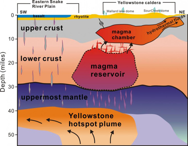
Cette coupe sud-ouest / nord-est sous Yellowstone a été obtenue grâce à l’imagerie sismique. (Source: University of Utah)

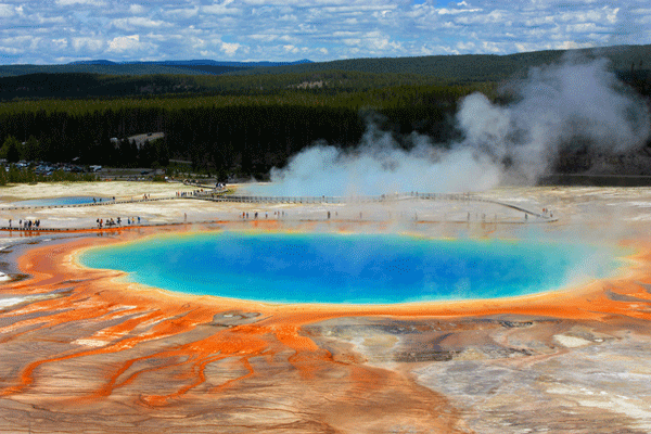
Un forage à Yellowstone, n’est-ce pas jouer avec le feu et risquer de saccager un site d’une beauté exceptionnelle? (Photo: C. Grandpey)


Projet de recherche sur l’île de Surtsey (Islande) // Research project on Surtsey (Iceland)

Façonnée par des éruptions qui ont eu lieu de 1963 à 1967, Surtsey, à environ 32 km au sud de la côte islandaise, est une île volcanique qui fait partie du Patrimoine Mondial de l’UNESCO qui la définit en ces termes : « Protégée dès sa naissance, elle fournit au monde un laboratoire naturel tout à fait remarquable. Libre de toute interférence humaine, Surtsey est une source unique et continue d’informations sur la colonisation d’une nouvelle terre par la vie végétale et animale ». Les oiseaux, les insectes et les phoques ont trouvé refuge sur Surtsey et des organismes étranges se sont installés sur les roches qui forment l’île. La chaleur du sous-sol a transformé les dépôts de téphra en tuf qui peut mieux résister aux assauts de l’océan.
Au vu de la définition de l’UNESCO, je pensais que Surtsey serait protégé contre toute ingérence humaine. C’était vrai … jusqu’à maintenant.
On peut lire sur le site Internet Iceland Review que « le plus grand projet de recherche sur l’île Surtsey depuis sa naissance en 1963-1967 débutera en août ». Les scientifiques vont procéder à des forages sur l’île et recueillir des échantillons et des données qui seront ensuite utilisés pour plusieurs projets différents. Le projet de recherche initial sera dirigé par un professeur de géophysique à l’Université d’Islande, en collaboration avec un autre professeur de l’Université de l’Utah et un groupe de scientifiques internationaux.
Le titre du projet est SUSTAIN et son objectif est de regrouper de nombreux domaines de recherche pour montrer comment s’est formée une île volcanique.
Le but est de prélever deux carottes, l’une issue d’un forage vertical de 200 mètres et une autre à partir d’un trou angulé de 300 mètres. Selon le projet, « l’apparition et l’évolution de la chaleur géothermale seront étudiées an tant qu’exemple d’un système géothermal de courte durée dans la zone de rift d’une croûte océanique ». Les micro-organismes et leur rôle sur l’île seront également étudiés et le trou de forage vertical sera utilisé pendant les décennies à venir pour effectuer d’autres recherches.
Tout cela signifie que Surtsey ne sera plus une terre intacte et bien protégée. On peut se demander si un tel projet vaut vraiment la peine. Est-ce que cela apportera plus d’informations qu’un forage similaire sur la grande île d’Islande?

——————————————

Formed by volcanic eruptions that took place from 1963 to 1967, Surtsey, approximately 32 km from the south coast of Iceland, is a volcanic island on the list of UNESCO’s World Heritage which defines it in these words: “ It is all the more outstanding for having been protected since its birth, providing the world with a pristine natural laboratory. Free from human interference, Surtsey has been producing unique long-term information on the colonisation process of new land by plant and animal life”. Birds, insects and seals have found their homes on Surtsey and strange organisms have settled down in the rocks that form the island. Geothermal heat has changed the loose tephra into tuff that can better withstand the surrounding ocean.

Reading UNESCO’s definition, I thought that Surtsey would be protected from any human interference. It was… up to now.

One can read on the website Iceland Review that “the biggest research project on the volcanic island of Surtsey since its creation will begin this August”. Scientists will be drilling holes in the island and gathering samples and data that will then be used for multiple different projects. The initial research project will be led by a Professor of Geophysics at the University of Iceland, along with another professor of the University of Utah and a group of international scientists.

The project title is SUSTAIN and its goal is to bring together many different fields of studies to show how a volcanic island is formed,

The plan is to take two drill cores, a 200-metre vertical core and a core from a 300-metre angled hole. According to the project, “the inner build and evolution of geothermal heat on the island will be researched as an example of a short-lived geothermal system in a rift zone of a oceanic crust.” Microorganisms and their role on the island will also be researched and the vertical drill hole will be used for decades to come for further investigations.

All this means that Surtsey will no longer be an unspoilt land and we may wonder whether such a project is really worth while. Will it bring more information than a similar drilling on Iceland’s main island?

Source: Iceland Review


Voyage au centre de la Terre // Journey to the centre of the Earth

Une équipe scientifique japonaise espère être la première à atteindre et explorer avec succès le manteau terrestre. Les chercheurs de l’Agence Japonaise pour la Science et la Technologie Mer-Terre (JAMSTEC) espèrent mieux comprendre comment la Terre s’est formée et quelle est la composition du manteau. Ce dernier représente plus de 80% de la masse de notre planète, à une dizaine de kilomètres sous le plancher océanique. Le gouvernement japonais, qui participe au financement de l’expédition, espère que les recherches pourront permettre de mieux prévoir les séismes.
Trois sites de forage sont actuellement à l’étude, tous dans l’océan Pacifique. L’un d’eux est au large des côtes hawaiiennes, un autre au large du Costa Rica et le dernier au large du Mexique. Pour accéder au manteau, la JAMSTEC veut utiliser le Chikyu, l’un des navires de forage les plus performants actuellement. C’est le plus grand navire de forage, avec une capacité de forage trois fois plus profonde que les navires précédents. Le trépan du Chikyu descendra à 4 kilomètres de profondeur dans les eaux océaniques avant d’atteindre plancher. Il perforera ensuite la croûte terrestre sur 6 kilomètres avant d’atteindre le manteau.
Les scientifiques ont déjà foré et récupéré des échantillons du fond de l’océan, mais seulement en surface. Ils veulent maintenant creuser le plancher océanique jusqu’au manteau proprement dit. Le forage débutera en 2030 au plus tard. Le projet a quatre objectifs principaux. Le premier (en cours) consiste à accéder au manteau de la planète en traversant le plancher océanique. Le deuxième objectif est d’étudier la frontière entre la croûte océanique et le manteau. Le troisième est de savoir comment s’est formée la croûte océanique. L’objectif final est d’examiner à quelle profondeur existe la vie microbienne à l’intérieur de la planète.
Source: CNN.

———————————-

A group of Japanese scientists plans to be the first to successfully drill into the Earth’s mantle. Researchers at Japan’s Agency for Marine-Earth Science and Technology (JAMSTEC) say they are hoping to discover more about how our planet was formed and what the mantle is composed of. The mantle makes up more than 80% of the entire Earth’s mass, lying about 10 km beneath the ocean floor. The Japanese government, which is helping fund the expedition, hopes the research could help discover ways to better predict earthquakes.

Three drilling sites are currently under consideration, all of them in the Pacific Ocean. One is off Hawaii, another one is off Costa Rica and the last one is off Mexico. To access the mantle, JAMSTEC wants to use one of the most advanced drilling vessels currently available, the Chikyu. It is the biggest drilling ship today, so the drilling capability is three times deeper than the previous vessels. The Chikyu’s drill will drop down through almost 4 kilometres of ocean before reaching the ocean floor. It will then bore through 6 kilometres of the sea floor, or the planet’s crust, before it reaches the mantle.

The scientists have already drilled and have taken some samples from the ocean floor but only from the top. They now want to dig from the ocean floor to the deep pristine mantle. Drilling will start by 2030 at the latest. The project has four primary objectives, only the first of which is to access the planet’s mantle by drilling through the sea floor. The second aim is to investigate the boundary between the oceanic crust and the mantle. The third one is to know how the oceanic crust formed. The final objective is to further examine how deep microbial life exists inside the planet.

Source: CNN.

Nodules de péridotite, roche magmatique qui constitue la majeure partie du manteau supérieur. (Photo : C. Grandpey)

De nouveaux forages en mer ? Pas si sûr ! // New offshore drilling ? Not so sure !

Fidèle à ses promesses électorales, Donald Trump envisage de donner des instructions au Département de l’Intérieur pour annuler la décision prise par le président Barack Obama en décembre de mettre à l’abri de tout forage des centaines de millions d’hectares d’océan au large des côtes américaines. La décision, qui devrait être officialisée dans les prochaines semaines, a pour but de développer l’exploration des ressources énergétiques américaines en annulant les restrictions mises en place par les administrations précédentes. Il faudra toutefois beaucoup de temps pour que de Département de l’Intérieur mette en application les aspects de la nouvelle directive.
La côte du Pacifique est fermée à toute nouvelle prospection de pétrole et de gaz depuis la marée noire catastrophique de Santa Barbara, en Californie, en 1969. Il n’y a pas eu de forage le long de la côte atlantique depuis le début des années 1980. Au début de son administration, Barack Obama a envisagé d’autoriser une étude sismique en vue de l’exploration pétrolière sur la côte sud-est des Etats-Unis, entre la Floride et la Virginie. Il ne s’est pas opposé à la Royal Dutch Shell quand la compagnie a entrepris de forer un puits exploratoire dans la mer des Tchouktches, au large de la côte arctique de l’Alaska; Le puits a été un échec et, à la fin de sa présidence, Obama a fermé de vastes zones à toute exploration.
Il existe une forte opposition au nouveau projet de forage. L’expansion des forages en mer dans de nouvelles zones des océans Arctique, Atlantique et Pacifique mettrait en danger des écosystèmes océaniques dynamiques et serait mauvais pour les entreprises. Cela menacerait des économies côtières prospères et des industries lucratives, y compris le tourisme, les loisirs et la pêche. Les chefs d’entreprise le long de la côte atlantique ont exprimé leur opposition à tout forage en mer. La volonté de forer dans l’Arctique, qui existe depuis des décennies, a mis en danger son écosystème unique et diversifié, a coûté des dizaines de milliards de dollars et créé une controverse importante sans résultat tangible.
Il n’est pas du tout certain que l’ouverture des mers des Tchouktches et de Beaufort aux forages pétroliers attire beaucoup de candidats. Après que Shell ait dépensé plus de 7 milliards de dollars dans un puits exploratoire qui s’est soldé par un échec, d’autres grandes compagnies pétrolières ont abandonné leurs projets de forage dans la région.
Sources: The Washington Post & Alaska Dispatch News.

—————————————-

The White House is considering issuing instructions to the Interior Department to reverse President Barack Obama’s withdrawal of hundreds of millions of offshore acres from future drilling in December 2016. The executive order, expected tocome out in the next few weeks, represents President Donald Trump’s latest attempt to promote domestic energy exploration by rolling back restrictions put in place by previous administrations, though it would take considerable time for Interior to carry out aspects of the proposed directive.

The Pacific coast has been closed to new oil and gas exploration since the disastrous oil spill off Santa Barbara, California, in 1969. There has been no drilling off the Atlantic coast since the early 1980s. Early in his administration, Obama considered allowing seismic work in preparation for exploration off the southeastern coast, from Florida to Virginia. And he did not move to stop Royal Dutch Shell from drilling an exploratory well in the Chukchi Sea off Alaska’s Arctic coast; the well turned out to be a dry hole. But near the end of his presidency he closed off vast areas.

There is widespread opposition to renewed drilling efforts. Expanding offshore drilling into new areas like the Arctic, Atlantic and Pacific oceans would put vibrant ocean ecosystems at risk and be bad for business, threatening thriving coastal economies and lucrative industries, including tourism, recreation and fishing. Business leaders along the Atlantic coast have been vocal in their opposition to offshore drilling, and the decades-long push to drill in the Arctic has put its unique and diverse ecosystem at risk, cost tens of billions of dollars and created significant controversy without profitable results.

It remains unclear whether opening up the remote Chukchi and Beaufort Seas for leasing would attract any bids. After Shell spent more than $7 billion to lease and drill an uneconomic well, other major oil companies have dropped plans to drill in the region.

Sources: The Washington Post & Alaska Dispatch News.

Puits de forage exploratoire de la compagnie Shell dans la mer des Tchouktches (Source : Polar News)