Concentrations de CO2 : 431,86 ppm (27 mai 2026)
Concentrations de CH4 : 1940,43 ppb (janvier 2026)
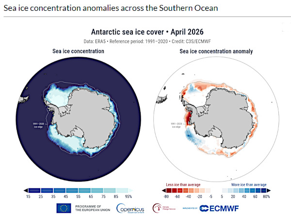
![]() Dans ma note du 31 mai 2026, j’explique que la chaleur de l’océan Austral fait fondre la banquise antarctique. C’est le cas d’une plate-forme glaciaire majeure qui est sur le point de se détacher du glacier Thwaites. Ce détachement déstabilisera encore davantage l’un des glaciers les plus grands et les plus vulnérables au monde.
Dans ma note du 31 mai 2026, j’explique que la chaleur de l’océan Austral fait fondre la banquise antarctique. C’est le cas d’une plate-forme glaciaire majeure qui est sur le point de se détacher du glacier Thwaites. Ce détachement déstabilisera encore davantage l’un des glaciers les plus grands et les plus vulnérables au monde.
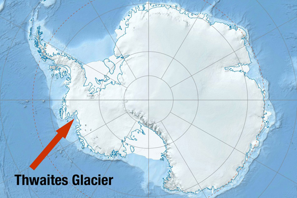
Le glacier Thwaites est surnommé le « glacier de l’apocalypse » car sa fonte et sa disparition entraîneraient un tel déversement de glace dans l’océan Austral que le niveau des mers s’élèverait de 65 centimètres, inondant des zones habitées dans le monde entier. Cet événement pourrait prendre des siècles, mais une menace imminente pèse sur la plate-forme glaciaire orientale du Thwaites, ce qui accélérera probablement la fonte du glacier.
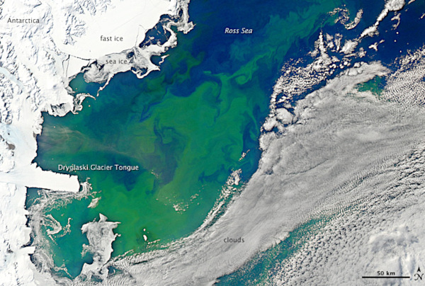
Selon des chercheurs, des images satellites révèlent que la plate-forme orientale du Thwaites est sur le point de se détacher du glacier. Alors que ce dernier repose sur la terre ferme, cette barrière de glace est une masse de glace flottante connectée au front du glacier. Les chercheurs ont encore beaucoup à apprendre sur ce glacier, mais cette barrière agit comme un rempart qui freine l’écoulement vers la mer de la rivière de glace située en amont. Les géophysiciens du British Antarctic Survey pensent que la plate-forme glaciaire devrait se rompre très probablement dès 2026.
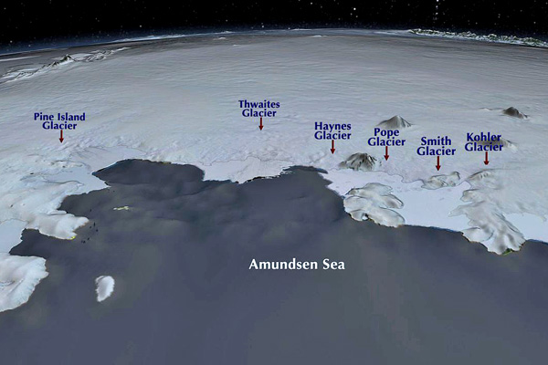
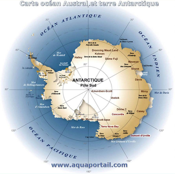
De la taille de la Floride, le glacier Thwaites est le plus grand glacier de l’Antarctique occidental. Ce gigantesque fleuve de glace atteint par endroits plus de 2 000 mètres d’épaisseur et son front s’étend sur 120 kilomètres, ce qui en fait le glacier le plus large de la planète.

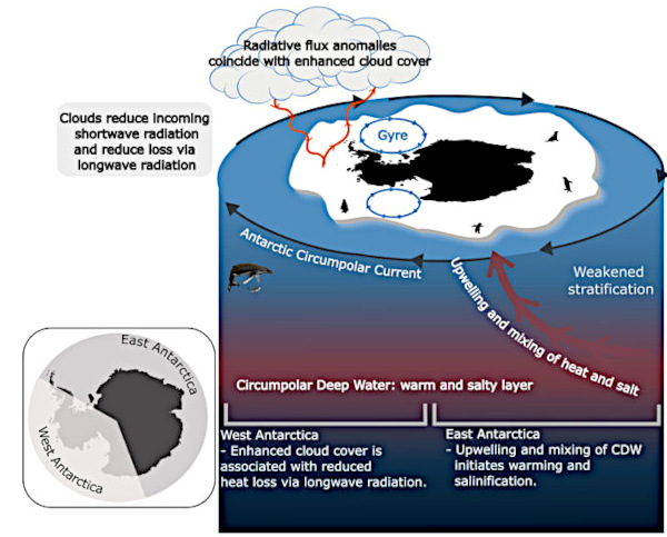
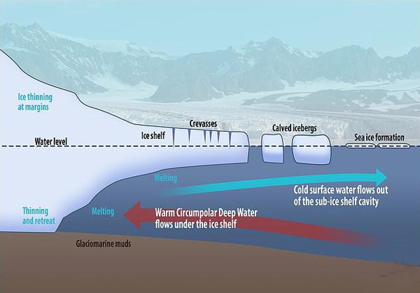
Le glacier fond rapidement depuis les années 1980, et perd des centaines de milliards de tonnes de glace. Comme expliqué précédemment, ce phénomène est dû aux eaux relativement chaudes de l’océan Austral qui viennent saper la plate-forme glaciaire par en dessous et font fondre le glacier à sa base, là où la glace repose sur le substrat rocheux sous le niveau de la mer. Selon le British Antarctic Survey, le glacier a reculé de 14 km depuis 1992.
Modéliser la disparition de glaciers aussi imposants que le Thwaites est une tâche complexe, et il et difficile de prévoir avec exactitude la date de la disparition du glacier Thwaites. Cependant, une étude publiée le 9 mars 2026 dans la revue Geophysical Research Letters a révélé que le glacier pourrait perdre entre 180 et 200 milliards de tonnes de glace par an d’ici 2067.
La fonte rapide de glaciers comme le Thwaites est considérée comme un point de basculement, ou « point de non-retour », dans le cadre du réchauffement climatique. Cela signifie qu’une fois franchis, ces points de non-retour entraînent des changements permanents qui ne pourront être inversés pendant des milliers d’années.
Source : Live Science. Images: Wikipedia et British Antarctic Survey.
——————————————-
![]() In my post of 31 May 2026, I explained that the heat of the Southern Ocean is melting Antarctic sea ice. This is what is happening at a vital ice shelf which is about to break away from Antarctica’s Thwaites Glacier. When this happens, it will further destabilize one of the world’s largest and most vulnerable glaciers.
In my post of 31 May 2026, I explained that the heat of the Southern Ocean is melting Antarctic sea ice. This is what is happening at a vital ice shelf which is about to break away from Antarctica’s Thwaites Glacier. When this happens, it will further destabilize one of the world’s largest and most vulnerable glaciers.
The Thwaites Glacier is nicknamed the « Doomsday Glacier » because its collapse would send so much ice into the Southern Ocean that global sea levels would rise by 65 centimeters, flooding coastal communities worldwide. This collapse could take centuries, but there is an imminent threat to Thwaites’ eastern ice shelf, which will likely accelerate the glacier’s demise.
Researchers say that satellite images reveal that the Thwaites eastern ice shelf is about to detach from the glacier. While the glacier sits on land, the ice shelf is a floating body of ice that is attached to the glacier’s mouth. Researchers still have a lot to learn about the glacier, but this shelf acts as a buttress, restraining the flow of ice from the glacier into the sea.
Geophysicists at the British Antarctic Survey warn that the ice shelf is very likely to break up in 2026.
Around the size of Florida, Thwaites Glacier is the largest glacier in West Antarctica. The gigantic river of ice is more than 2,000 meters thick in some parts and 120 kilometers across, making it Earth’s widest glacier.
The glacier has been melting rapidly since the 1980s, losing hundreds of billions of tons of ice. As I explained before, this is due to relatively warm water from the Southern Ocean flowing underneath the ice shelf and melting the glacier at its base, where ice sits on ground below sea level. According to the British Antarctic Survey, the glacier has retreated 14 km since 1992.
Modeling the demise of massive glaciers is a complex task, making it hard to put an exact date on when Thwaites Glacier will finally collapse. However, a study published March 9 2026 in the journal Geophysical Research Letters found that the glacier could be losing 180 billion to 200 billion tons of ice per year by 2067.
The collapse of ice sheets like this one are considered tipping points, or « points of no return, » in the fight against global warming. This means that once they are crossed, they bring about permanent changes that cannot be reversed for many thousands of years.
Source : Live Science.