Les autorités guatémaltèques ont émis un avis d’alerte le 2 mars lorsque le Fuego a connu un nouvel épisode éruptif. Le volcan a envoyé des panaches de cendre à plus de 2.000 mètres au-dessus du cratère ; ils se sont ensuite étirés sur plus de 40 kilomètres vers l’ouest, le sud-ouest et le nord. Plusieurs localités à proximité du volcan ont reçu une fine couche de cendre, mais aucune évacuation n’a été jugée nécessaires et l’INSIVUMEH indique dans son dernier rapport que la crise éruptive est terminée.
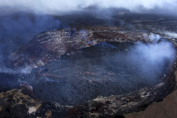
Le niveau de la lave demeure élevé (30 mètres en dessous de la lèvre) dans l’Halema’uma’u Crater, mais la lave n’est pas visible depuis la terrasse du Musée Jaggar. Le spectacle dépend du processus d’inflation et de déflation du Kilauea.
Pendant ce temps, une nouvelle coulée de lave est apparue sur le plancher du Pu’uO’o qui est également influencé par le comportement du Kilauea. Le petit cône situé dans la partie E du cratère a émis brièvement de la lave, suivi d’une coulée plus importante à partir d’une bouche dans la partie ouest du cratère. L’émission de lave se poursuit au moment où je rédige cette note.
La télévision américaine NBC News a mis en ligne une vidéo montrant l’activité spectaculaire du Tungurahua hier mercredi 2 mars 2016:
http://www.nbcnews.com/video/watch-throat-of-fire-volcanos-spectacular-show-635713091734
———————————-
 Guatemalan authorities issued a warning on March 2nd as Fuego went through another eruptive episode. The volcano sent ash plumes more than 2,000 metres above the crater, bedore drifting over 40 kilometres to the west, southwest and north. Several municipalities surrounding the volcano reported fine ash particles falling from the sky. So far no evacuations had been deemed necessary and INSIVUMEH indicated in its latest report that the eruptive crisis was over.
The level of lava remains high (30 metres below the rim) within Halema’uma’u Crater but lava is currently not visible from the terrace of the Jaggar Museum. Whether it can be seen or not depends on the inflation and deflation process of Kilauea volcano.
Meantime, a new lava flow has appeared on the floor of Pu’uO’o Crater which is also influenced by the behaviour of Kilauea. The small cone on the east side of the crater floor briefly erupted spatter, followed by a more vigorous flow from the westernmost vent. The lava emission is continuing as I am posting this note.
The NBC News TV channel has released a video of Tungurahua‘s dramatic activity yesterday, Wednesday March 2nd, 2016:
http://www.nbcnews.com/video/watch-throat-of-fire-volcanos-spectacular-show-635713091734
 Selon une note mise en ligne le 15 mars sur le site VolcanoDiscovery, l’activité reste soutenue à l’intérieur du cratère du Nyiragongo. La nouvelle bouche apparue sur la terrasse inférieure continue à émettre de la lave sous forme de fontaines d’une trentaine de mètres de hauteur. Comme on peut le voir sur la photo qui accompagne l’article, la coulée de lave qui s’échappe de la bouche a maintenant atteint le rebord du lac de lave et s’écoule en cascades à l’intérieur.
 According to a post released on March 15th on the VolcanoDiscovery website, activity remains high within the crater of Nyiragongo volcano. The new vent that appeared on the lowest terrace is still emitting lava, together with fountains about 30 metres high. As can be seen on a photo that was released with the article, the accompanying lava flows have now reached the rim of the central lake and started to cascade into it.