Le Katla et le risque de tsunami aux Iles Vestmann // Katla Volcano and the tsunami hazard in Vestmannaeyjar

drapeau-francaisSi une éruption du Katla venait à se produire, on pense qu’une crue brutale due à la fonte du glacier Mýrdalsjökull pourrait déclencher un raz-de-marée susceptible de frapper les Iles Vestmann au sud de l’Islande. Cette éventualité a été abordée récemment lors d’une réunion organisée par le chef de la police des Iles Vestmann, avec la présence du responsable des risques naturels au Met Office islandais et du volcanologue Ármann Höskuldsson de l’Université d’Islande.
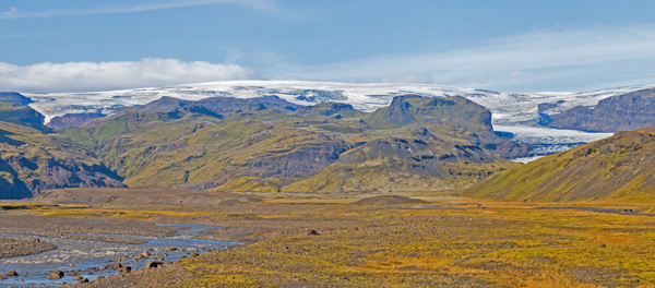
On sait depuis quelque temps que parmi les conséquences des éruptions du Katla figurent les raz-de-marée le long de la côte sud. Dans le passé, de telles vagues ont été suffisamment puissantes pour causer des dégâts jusqu’à Grindavík, à 230 km à l’ouest. La ville de Vík, sur la côte sud à quelques kilomètres du Mýrdalsjökull, serait probablement concernée par une inondation soudaine provoquée par le glacier. Les îles Vestmann se trouvent à vol d’oiseau à seulement une cinquantaine de kilomètres à l’ouest de Vík.
En 1918, lors de la dernière éruption du Katla, il y a eu des vagues qui ont déferlé sur les îles Vestman. En conséquence, il est important que dans un gros port de pêche comme Heimaey les gens soient préparés à un tel événement. La principale zone industrielle de la ville se trouve près du port qui serait forcément frappé par un raz-de-marée.
Cependant, on pense qu’il y aurait assez de temps pour mettre en place une évacuation. Habituellement, le panache éruptif du Katla sort du glacier avant que se déclenche la crue glaciaire. A en juger par les récits du passé, le raz-de-marée intervient une fois que l’eau de la crue a atteint le rivage. Quand on apercevra le panache éruptif, il faudra donc que les gens aillent se réfugier sur des zones plus élevées pendant quelques heures, en attendant de voir si le raz-de-marée va se produire.
La nécessité de mettre en place un équipement sismique plus important dans les Iles Vestmann a également été discutée lors de la réunion.
Source: Iceland Review.

—————————————-

drapeau-anglaisShould an eruption of Katla volcano occur, it is believed that a flash flood from Mýrdalsjökull glacier might trigger a tidal wave likely to hit the Westman Islands off South Iceland. The scenario was recently discussed at a meeting organized by the Chief of Police in the Westman Islands, with the director of natural hazards at the Icelandic Meteorological Office, and volcanologist Ármann Höskuldsson from the University of Iceland.

It has been known for some time that among the consequences of eruptions in Katla are tidal waves along the south coast. In the past, such tidal waves were large enough to cause damage all the way to Grindavík which is located 230 km to the west. The town of Vík, located on the south coast just a few kilometres from Mýrdalsjökull, would almost certainly be hit by a flash flood from the glacier. The Westman Islands lie approximately 50 km to the west of Vík in a straight line.

 In 1918, during Katla’s last eruption, there were waves washing up on the Westman Islands. As a consequence, it is important that in a big and important fishing town like Heimaey people should be prepared. The town’s largest industrial area is down by the harbour which would naturally be affected by a tidal wave.

However, it is believed that there would be time for an evacuation. Usually Katla’s eruptive plume extends from the glacier before the flash floods occur. Judging by the accounts, the tidal waves occur after the flash floods have reached the shore. When a plume is sighted, it will be safer for people to move to a higher ground for a few hours while waiting to see whether the tidal wave will happen.

The necessity to establish more earthquake monitors in the Westman Islands was also discussed at the meeting.

Source: Iceland Review.

heimaey

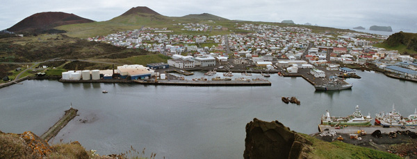
Vue du port d’Heimaey, dans les Iles Vestmann (Crédit photo: Wikipedia)

Surveillance sismique du Katla (Islande) // Katla’s seismic monitoring (Iceland)

Un séisme de M 3.4 a été enregistré sur le Katla à 13 h 41 le 14 décembre 2016, à une profondeur de 0,1 km. Comme les événements précédents, il n’était probablement pas lié à une ascension du magma, mais plutôt au mouvement des fluides hydrothermaux sous le volcan. Aucune réplique ne s’est produite.
Fin novembre, un groupe de scientifiques a remplacé un certain nombre d’appareils de mesure au bord de la caldeira du Katla. Vous pourrez les voir au travail en cliquant sur le lien ci-dessous. C’est mieux si vous comprenez l’islandais, mais la vidéo offre des vues intéressantes du volcan.
http://www.ruv.is/frett/katla-i-gjorgaeslu

——————————————

An M 3.4 earthquake was registered on Katla volcano at 1:41 pm on December 14th 2016, at a depth of 0.1 km.Like the previous events it was probably not linked to any magma ascent, but rather to the movement of hydrothermal fluids beneath the volcano. No afttershocks have occurred.

Late in November, a group of scientists replaced a number of meters on the edge of the volcano’s caldera. You can watch them install the equipment by clicking on this link. It is better if you understand the Icelandic language, but the video offers interesting views of the volcano.

http://www.ruv.is/frett/katla-i-gjorgaeslu

Katla & Myrdalsjökull (Islande): Aucune explication de l’essaim sismique // No explanation for the seismic swarm

drapeau-francaisLa crise sismique qui a culminé vendredi sur le glacier Myrdalsjökull et le volcan Katla est maintenant terminée et la route qui avait été fermée – après la fin de l’essaim sismique! – a été rouverte à la circulation.
Le Conseil consultatif du Département de Protection Civile islandais s’est réuni lundi matin pour faire le bilan de l’activité sismique qui a commencé jeudi dernier.
Voici les principales conclusions du Conseil:
« L’événement sismique est le plus important enregistré sur le Katla depuis des décennies. L’activité sismique a diminué de façon spectaculaire, après avoir atteint un sommet vendredi.

La cause la plus probable de cette activité sismique est le mouvement du magma dans la croûte terrestre, mais aucune preuve de ce mouvement ne s’est manifesté à la surface du glacier.
L’épisode sismique semble être terminé.
L’activité sismique sur le Katla au cours des deux derniers mois a été nettement plus intense qu’au cours des dernières années. Il est difficile de savoir si l’activité se poursuivra ou si elle va continuer à diminuer. »
En d’autres termes, toute prévision est impossible, ce qui confirme nos limites dans ce domaine. Le Katla est un volcan bien surveillé, avec une batterie d’instruments sur et autour de ce volcan. Malgré tout cet équipement, les scientifiques islandais ont été incapables de détecter la cause de la sismicité des derniers jours.
Ce qui me surprend, c’est que si la sismicité à très faible profondeur (souvent une centaine de mètres) a été causée par une montée de magma, le tremor aurait réagi, ce qui n’est pas le cas. Par ailleurs, il y aurait probablement eu une augmentation des températures susceptible de provoquer des inondations des rivières qui sortent du glacier. Il est surprenant que le Conseil consultatif ne mentionne plus la possibilité de mouvements de fluides hydrothermaux. Enfin, il ne faudrait pas oublier que le volcan Katla se trouve sous un glacier et que les mouvements de la glace peuvent également avoir un effet sur les sismographes. Personne n’a encore mentionné le réchauffement climatique et la fonte du glacier. On sait que des effondrements se produisent à l’intérieur d’un glacier et peuvent, eux aussi, déclencher des essaims sismiques semblables à ceux provoqués par l’activité volcanique.

Affaire à suivre….

———————————–

drapeau-anglaisThe seismic crisis that peaked on Friday on Myrdalsjökull glacier and Katla volcano is now over and the road that had been closed – after the end of the seismic swarm! – has been reopened.

The Scientific Advisory Board of Iceland’s Civil Protection Department met on Monday morning to discuss the seismic activity which began last Thursday.

Here are theBoard’s main conclusions:

“The seismic event is the largest one in Katla for decades. Seismic activity has now decreased dramatically, having peaked in power on Friday.

The most likely reason for the seismic activity is magma movement in the earth’s crust, but no evidence of such movements has manifested itself on the surface of the glacier.

The seismic episode appears to be over.

Seismic activity in Katla over the last two months has been significantly greater than at any time over the last few years. It is unclear whether the activity will continue or if it will decrease even further.”

In other words, no prediction is possible, which shows once again our limits in this domain. Katla is a well controlled volcano, with a battery of instruments on it and around it. Despite all this equipment, Icelandic scientists were unable to detect the cause of the past seismicity.

What surprises me is that if the very shallow seismicity (often only 100 metres deep) was caused by some magma ascent, the tremor would have reacted to the phenomenon. Besides, there probably would have been an increase in temperatures likely to cause some flooding of the rivers that emerge from the glacier. It is surprising that the Scientific Advisory Board no longer mentions the possibility of hydrothermal fluid movements. At last, one should not forget that Katla volcano sits under a glacier and that movements of the ice may also have an effect on the seismographs. Nobody has yet mentioned global warming and the melting of the glacier. It is well known that collapses occur inside the glacier and may trigger seismic swarms, just like volcanic activity does.

Wait and see…

myrdalsjokull-2

Vue du Myrdalsjökull (Crédit photo: Wikipedia)


Islande: Fermeture de route autour du Myrdalsjökull // Iceland: Road closure around Myrdalsjökull

drapeau-francaisTrès étrange : Comme je l’ai écrit auparavant, la sismicité au niveau du Katla est en baisse depuis samedi. Malgré cela, la Protection Civile a décidé ce même jour de fermer la route qui conduit au glacier Sólheimajökull et cette route est restée fermée hier dimanche. Il était également interdit de s’aventurer sur le glacier. D’après la police du sud de l’Islande, la situation sera réexaminée ce lundi.

Il est demandé aux touristes de ne pas camper entre Skógar et Dyrhólavegur, ainsi qu’entre l’entrée est de Vík et la rivière Kúðafljó.

Source : Iceland Review.

———————————–

drapeau-anglaisVery strange indeed : As I put it before, seismicity on Katla volcano has been declining since Saturday. Despite the decrease, the department of Civil Protection closed the road to Sólheimajökull glacier on Saturday and the road was also closed yesterday Sunday. It is forbidden to walk onto the glacier. According to South Iceland police the situation will be assessed again on Monday.

People are also asked not to camp anywhere between Skógar and Dyrhólavegur and not from the east edge of the town of Vík to Kúðafljó river.

Source : Iceland Review.

myrdals-blog

Vue du Sólheimajökull (Photo: C. Grandpey)