Le Met Office islandais croit toujours à une nouvelle éruption // The Icelandic Met Office still believes in a new eruption

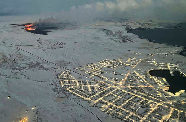
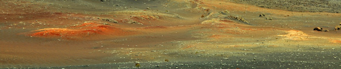
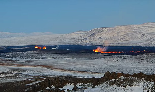
Après l’éruption ratée du 2 mars 2024, le Met Office indique que le niveau de magma sous le secteur de Svartsengi continue d’augmenter. Cela pourrait déboucher sur une nouvelle éruption qui pourrait démarrer dans un délai très court, peut-être moins de 30 minutes. Il est également très probable qu’une éruption se produise entre Stóra-Skógafell et Hagafell.
Le Met Office indique également que les calculs de probabilité montrent que le volume de magma qui s’est déplacée le 2 mars entre Svartsengi et la chaîne de cratères de Sundhnúkagígar était de 1,3 million de mètres cubes.
Les scientifiques avaient précédemment calculé qu’environ 500 000 mètres cubes de magma s’accumulaient chaque jour sous Svartsengi. Si cette donnée reste inchangée, le volume total de magma sous Svartsengi atteindra environ 9 millions de mètres cubes d’ici la fin de journée du 5 mars 2024.
Par ailleurs, le Met Office rappelle que lors des événements précédents, une éruption s’est produite lorsque le volume total accumulé était compris entre 8 millions et 13 millions de mètres cubes. Il est donc très probable qu’une nouvelle éruption se produise une fois ce volume atteint.
La question est de savoir si l’intrusion magmatique, qui est un phénomène naturel, confirmera les prévisions des modélisations qui appartiennent à la science exacte.

Le Met Office accepte mal son échec de prévision du 2 mars 2024…

————————————————

After the failed eruption of March 2nd, 2024, the Met Office indicates that magma levels under the Svartsengi area are continuing to increase, which could end in a new eruption that could start with very short notice, even less than 30 minutes. It is also most likely that an eruption will occur between Stóra-Skógafell and Hagafell.

The Met Office also says that probability calculations show that the amount of magma that ran on March 2nd from Svartsengi to the Sundhnúkagígar crater row was 1.3 million cubic meters.

It was previously calculated that about half a million cubic meters of magma accumulates under the Svartsengi channel every day. Unchanged, the total magma level under the Svartsengi channel will reach about 9 million cubic meters by the end of March 5th, 2024.

Furthermore, the Met Office reminds that in previous events, an eruption occurred when the total volume accumulated was between 8 million and 13 million cubic meters. There is therefore an increased chance of a new volcanic eruption once this amount has been reached.

The question is to know whether the magma intrusion, which is a natural phenomenon, will confirm the predictions of model calculations which belong to exact science.

Islande : l’éruption ratée du 2 mars 2024 // Iceland : the failed eruption of March 2nd, 2024

Le 2 mars 2024, la plupart des volcanologues islandais pensaient qu’une éruption était imminente en raison de la quantité de magma qui s’était accumulée au niveau de l’intrusion. Le volume avait dépassé cekui qui avait provoqué la dernière éruption. La péninsule de Reykjanes a été mise en état d’alerte ; Grindavík et le Blue Lagoon ont été évacués. Les trois principales routes d’accès à Grindavík, la Grindarvíkurvegur, la Nesvegur et la Suðurstrandarvegur ont également été fermées. Les ouvriers étaient en alerte avec des bulldozers et des pelleteuses, prêts à combler les trous ménagés pour permettre aux routes de traverses les digues de terre. Le Met Office islandais a annoncé que la probabilité d’une éruption était très élevée, peut-être dans quelques heures, voire quelques minutes.
À 17h30, le Met Office a annoncé qu’un intense essaim sismique était enregistré à l’est de Sýlingarfell et qu’une éruption fissurale était probable. La sismicité se déplaçait vers le sud en direction de Hagafell, mais les mesures GPS montraient moins de déformation du sol qu’avant les éruptions précédentes.
Plus tard dans la soirée, le Met Office a annoncé que la sismicité avait cessé et que l’intrusion magmatique s’était probablement arrêtée temporairement. Des déformations mineures ont continué à être mesurées dans la zone, de sorte que le Met Office n’a pas voulu indiquer que l’intrusion était terminée, même s’il ne semblait pas que le magma se déplaçait vers la surface.
Les volcanologues islandais pensent qu’une nouvelle intrusion magmatique s’est probablement formée entre Sýlingarfell et Hagafell, ce qui a provoqué une chute de pression. La probabilité d’une éruption imminente a donc diminué, du moins pour le moment, mais la probabilité d’une nouvelle éruption reste élevée.
Une fois de plus, cette situation montre la fragilité de la prévision volcanique. Aucune éruption ne s’est produite au cours du week-end, comme l’avait prédit un chercheur de l’Université d’Islande. Le problème est que l’éruption prévue depuis plusieurs jours n’aura pas lieu dans une zone désertique. Elle pourrait vite devenir une menace pour une zone habitée et pour des infrastructures essentielles. Il ne reste plus qu’à attendre la suite des événements…
Source : Moniteur d’Islande.

Aucun événement sismique significatif n’a été détecté durant le week-end et la situation est très calme ce lundi matin. Cependant, tout le monde sait que les choses peuvent changer rapidement.

Grindavik reste sous la menace de la lave (Crédit photo: Iceland Review)

————————————————–

On March 2nd, 2024, most specialists in volcanology thought that an eruption was pending due to the amount of magma accumulated in the magma channel, which had exceeded the amount that caused the last eruption to occur. Everything went on high alert and both Grindavík and the Blue Lagoon were evacuated. The three main access roads to Grindavík, Grindarvíkurvegur, Nesvegur and Suðurstrandarvegur were also closed. Workers were standing on alert with pushers and excavators, ready to fill in holes where roads run through the defenses.The Icelandic Met Office announced that the likelihood of an eruption was very high, and possibly within hours, if not minutes.

At 17:30 the Icelandic Met Office announced that an intense swarm of microseismic activity was occurring east of Sýlingarfell and that a fissure eruption was likely. The seismicity was moving south toward Hagafell but GPS-based measurements showed fewer signs of deformation than before previous eruptions.

Later in the evening, the Icelandic Met Office announced that the seismicity had ceased, and that the magma intrusion had probably stopped temporarily. Minor deformation continued to be measured in the area, so the Met Office did not want to issue a statement that the magma intrusion had ended, although it did not seem like the magma would be propagating to the surface.

Icelandic volcanologists think that a new magma channel probably formed, stretching between Sýlingarfell and Hagafell, which had decreased the pressure. Therefore the likelihood of a pending eruption diminished, at least for now. However, the likelihood of another eruption is still high.

Once again, this situation shows the fragility of volcanic prediction. An eruption did not occur during the weekend, as predicted by a University of Iceland researcher. The problem is that the likely eruption will not take place in a desert area. It might soon become a threat to a populated area and to essential infrastructure. Let’s see what happens next.

Source : Iceland Monitor.

No significant seismic event has been detected during the weekend and the situation is very quiet this Monday morning. However, evrybody knows that things may change rapidly.

Eruption aux Galapagos (Equateur) // Eruption in the Galapagos archipelago (Ecuador)

Le volcan La Cumbre, sur l’île Fernandina aux Galapagos est entré en éruption le 2 mars 2024, projetant de la lave sur ses flancs, avec des coulées qui se sont dirigées vers la mer. La lave a été émise par une fracture de 3-5 km de long dans la partie supérieure du flanc SE du volcan. Selon l’Institut géophysique de l’Équateur, au vu de la déformation du sol, il pourrait s’agir de la plus grande éruption depuis 2017. La dernière a eu lieu en 2020.
Des images partagées sur les réseaux sociaux, prises par des touristes aux Galapagos, montrent le volcan se profilant sur un ciel rouge.
Bien que l’éruption ne présente aucun risque pour les humains, l’île abrite un certain nombre d’espèces, notamment des iguanes, des manchots et des cormorans. En 2019, des scientifiques ont découvert sur l’île une tortue géante qu’on n’avait pas vue depuis plus d’un siècle et dont on craignait l’extinction.
Le volcan La Cumbre est l’un des plus actifs des Galapagos qui sont célèbres dans le monde entier pour avoir permis au 19ème siècle à Charles Darwin de développer sa théorie de l’évolution.

Source : presse internationale.

Vue de l’éruption le 3 mars 2024 (Crédit photo : Parc National des Galapagos)

Image d’une éruption (probablement de 2018)  diffusée sur les réseaux sociaux

———————————————–

The La Cumbre volcano on Fernandina island in the Galapagos began erupting on March 2nd, 2024, sending lava tumbled down its sides toward the sea. Lava emerged from a 3 – 5 km long fissure on the upper southeastern slope of the volcano. According to Ecuador’s Geophysical Institute, judging from ground deformation, it could be its largest eruption since 2017. The last eruption occurred in 2020.

Images shared on social media taken by visitors to the Galapagos show the volcano profiled against a crimson red sky.

While the eruption poses no risk to humans, the island is home to a number of species, including iguanas, penguins and cormorants. In 2019, scientists found on the island a giant tortoise not seen in more than a century and had been feared extinct.

The La Cumbre volcano is one of the most active in the Galapagos Island chain, which is famous throughout the world for helping 19th century British scientist Charles Darwin develop his theory of evolution.

Source : International news media.

Dernières nouvelles d’Islande // Latest news from Iceland

Dans l’après-midi du 2 mars 2024, vers 16h00 (heure locale), une intrusion magmatique a été détectée par les instruments à 1 kilomètre à l’est de Sýlingarfell, après une intense activité sismique dans la zone. Selon le Met Office islandais, cette activité indiquait qu’une éruption était susceptible de se déclencher. Les habitants encore présents à Grindavik ont été évacués, ainsi que le Blue Lagoon. Les volcanologues s’attendaient à ce qu’une éruption se produise à l’est de Sýlingarfell. Ensuite, l’activité a semblé se déplacer vers le sud, en direction de Grindavik. Le magma semblait se trouver à une profondeur d’environ quatre kilomètres, ce qui pouvait signifier quelques heures, voire moins, avant une éruption.
Puis, patatras ! Environ deux heures après son début, l’activité sismique a soudainement diminué, sans aucune indication que le magma était en train de remonter vers la surface. L’éruption a probablement avorté, phénomène que j’ai pu observer dans la région de Krafla dans les années 1990.
Aujourd’hui 3 mars au matin, la situation n’a pas évolué. La sismicité reste très faible sur la péninsule de Reykjanes. On va voir ce qui va se passer maintenant. Une fois de plus, nous constatons les limites de la prévision volcanique.

Il va falloir attendre un peu avant de voir la lave percer la surface….

———————————————–

In the afternoon of March 2nd, 2024, at about 4:00 pm (local time), a magma flow had started 1 kilometre east of Sýlingarfell, following intense seismic activity in the area. The Icelandic Meteorological Office stated that the activity indicated that a volcanic eruption might start as a result. The residents still living in Grindavik were evacuated, as well as the Blue Lagoon. Avolcanic eruption was expected to occur east of Sýlingarfell. Next, activity seemed to be moving south, toward Grindavik. The magma appeared to be at a depth of approximately four kilometres, which could mean a few hours until an eruption, or even less time.

About two hours after it began, seismic activity suddenly decreased, with little indication that the magma was coming to the surface. Thee eruption may have aborted, a phenomenon that I could observe in the Krafla area in the 1990s.

Today March 3rd in the morning, the situation has not changed. Seismicity ids still very low on the Reykjanes Peninsula. Let’s see what will happen next. Once again, we can see the limits of volcanic prediction.