 15 heures: Une équipe de géologues Tonga a finalement réussi à atteindre le site de l’éruption qui a commencé le mois dernier et qui restait spectaculaire. Ils ont pu se rendre mieux compte de la situation.
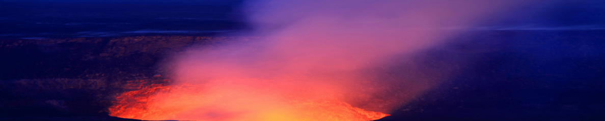
C’est ainsi qu’ils ont découvert que la bouche éruptive ne s’était jamais manifesté récemment et qu’elle était plus grande que prévu, avec un diamètre de 400-500 mètres et une profondeur d’environ 90 mètres. Lors de la visite, les explosions se produisaient toutes les 5 minutes et projetaient des nuages de cendre et de vapeur jusqu’à 500 mètres de hauteur. Les géologues ont pu aussi sentir la pluie acide qui va de pair avec l’éruption.
Comme je l’ai écrit auparavant, l’éruption a provoqué l’annulation de dizaines de vols au départ de Nouvelle-Zélande, Fidji et Australie. Cependant, la situation est redevenue quasi normale au cours des dernières heures, même si l’éruption n’est pas complètement terminée et si plusieurs vols ont été annulés ou retardés à cause de la cendre.
Une équipe de géologues néo-zélandais retournera sur l’île pour un nouvel examen de la situation.
Voici une petite vidéo tournée depuis le bateau qui transportait les géologues :
http://www.3news.co.nz/world/tongan-geologists-get-up-close-to-volcano-2015011518
°°°°°°°°°°
17 heures: Au fur et à mesure que le temps passe, on obtient plus d’informations sur l’éruption. Comme prévu, une équipe comprenant deux volcanologues du GNS néo-zélandais est allée observer l’éruption le 14 janvier.
La conclusion des observations est qu’une nouvelle île a été façonnée par l’éruption entre les îles existantes de Hunga Tonga et Hunga Ha’apai, et elle est maintenant jointe à Hunga Ha’apai.
La nouvelle île a plus de 1 km de large, environ 2 km de long et environ 100 m de haut. Pendant les observations effectuées par les Néo-Zélandais, les éruptions se produisaient environ toutes les cinq minutes, comme avec les Tonguiens. Des panaches de cendre denses montaient à une hauteur d’environ 400 mètres. Au-dessus d’environ 1000 mètres, le panache éruptif était composé presque exclusivement de vapeur. Comme la cendre est très humide et lourde, la majeure partie retombe près de la bouche éruptive, contribuant à l’édification de la nouvelle île. Des surges de cendre et de vapeur partaient parfois à l’horizontale pendant les séquences éruptives, avec des projections jusqu’à plus de 1 km de la bouche éruptive. Des retombées de cendre et des pluies acides ont été observées jusqu’à 10 km de l’éruption.
Selon les volcanologues du GNS, cette éruption est semblable à celle de Hunga Ha’apai en 2009, mais elle produit un plus grand volume de matériaux.
Les pilotes ont signalé des panaches de vapeur en provenance de la zone de Hunga Ha’apai et Hunga Tonga, mais cela fait plusieurs jours qu’ils n’observent pas d’émissions de cendre importantes aux altitudes auxquelles volent les avions. Comme je l’ai écrit auparavant, les vols internationaux ont repris le 14 janvier après plusieurs jours d’annulations. La compagnie aérienne nationale est opérationnelle elle aussi.
Source: Matangi TongaOnline, avec plusieurs photos de l’éruption:
http://matangitonga.to/2015/01/16/new-island-forms-tonga
—————————————————–
 A team of Tongan geologists have finally managed to reach the site of the eruption which started last month. What they saw was spectacular, and they could get a better view of the situation.
They discovered it was the first time this particular vent had erupted – and it was bigger than they anticipated, with a diameter of 400-500 metres and a depths of 90 metres or so. During the visit, there were explosions every five minutes sending steam and ash clouds up to 400 metres high. The geologists could also feel the acid rain that goes with the eruption.
As I put it before, the eruption cancelled dozens of flights from New Zealand, Fiji and Australia. However, the situation was going back to normal in the past hours, even though the eruption is not completely over and several flights were still cancelled or postponed.
A team of NZ geologists will return to the island for another look
Here is a short video shot from the boat that visited the eruption site:
http://www.3news.co.nz/world/tongan-geologists-get-up-close-to-volcano-2015011518
°°°°°°°°°°
17:00: As time passes by, we get more news about the eruption. As had been planned, a team including two GNS volcanologists from New Zealand went out to observe the erupting volcano on January 14th.
The conclusion of the observations is that a new island has been built by the eruption between the existing islands of Hunga Tonga and Hunga Ha’apai, and is now joined to Hunga Ha‘apai.
The new island is more than 1 km wide, about 2km long and about 100 m high. During the Kiwi observations the volcano was erupting about every five minutes, as it was doing with the Tongans. Dense ash was being erupted to a height of about 400 metres. Above about 1000 metres, the eruption plume was almost exclusively steam. As the ash is very wet and heavy, most of it is being deposited close to the vent, building up the new island. Hazardous surges of ash and steam were seen to spread out horizontally during eruptions, as far as more than 1 km from the erupting vent. Ashfall and acidic rain was observed within 10 km of the eruption.
According to the GNS volcanologists, this eruption is similar to that at Hunga Ha’apai in 2009, but producing a larger volume of materials building the island.
Pilots have reported steam plumes from the Hunga Ha’apai and Hunga Tonga area, but substantial ash emission to the altitudes at which aircraft fly have not been observed for several days. As I put it before, international flights resumed on the January 14th after several days of cancellations. The domestic airline is currently also operating.
Source : Matangi Tonga Online, with several photos of the eruption :
http://matangitonga.to/2015/01/16/new-island-forms-tonga
 Le Soputan (Nord Sulawesi) a connu une crise éruptive ce dimanche à 11h38 (03 :38 TU) avec un panache de cendre qui est monté jusqu’à 4 km au-dessus du cratère. Les villageois ne sont pas autorisés à pénétrer dans une zone de 6,5 km de rayon autour du cratère. Aucun autre événement éruptif n’a été observé après l’épisode de ce matin. Le volcan connaissait une hausse d’activité depuis mercredi et était déjà entré en éruption à deux reprises le 6 janvier. Aucune victime n’est à déplorer.
