
 Une étude récente menée auprès des agriculteurs hawaïens par le Département d’agriculture tropicale et des ressources humaines a révélé que la dernière éruption du Kilauea avait causé près de 28 millions de dollars de dégâts. Les 46 fermiers qui ont participé à l’étude ont déclaré avoir perdu environ 27,9 millions de dollars suite à la destruction de leurs biens. Parmi les dégâts signalés, près des deux tiers – soit 17 millions de dollars – concernent plus particulièrement les récoltes, tandis que les terres, les bâtiments et les stocks détruits représentent respectivement 4,1 millions de dollars, 3,3 millions de dollars et 3 millions de dollars de pertes.
Un rapport de l’Association de la floriculture et des pépinières d’Hawaï a fait remarquer que les données contenues dans l’étude n’étaient pas exhaustives, mais fournissaient un bon aperçu de la gravité de l’impact de l’éruption sur l’agriculture de l’île. L’étude a révélé que 13,3 millions de dollars de dégâts concernent la floriculture, 6,5 millions de dollars la culture de la papaye et 2,5 millions de dollars les noix de macadamia.
La région de Kapoho, aujourd’hui en grande partie recouverte par la lave, offrait des conditions idéales pour faire pousser les orchidées. Après l’éruption, on a estimé que 10% des quelque 300 plantations d’orchidées à travers l’Etat avaient été touchés. Même si certaines nouvelles pépinières ont vu le jour, il faut parfois jusqu’à deux ans pour qu’une graine d’orchidée devienne une plante vendable dans des conditions idéales, et c’est une période pendant laquelle les agriculteurs ne disposent d’aucun revenu.
Environ 30 à 40% de la production de papaye de la Grande Ile a été détruite ou rendue inaccessible par l’éruption, avec un préjudice économique immédiat pour le secteur. Quelque 285 hectares de la meilleure zone de culture de la papaye ont été ensevelis sous la lave, ce qui soulève des questions sur l’avenir de ce secteur agricole. La plus grande partie de la récolte de papayes qui a été détruite était destinée à Oahu ou au Canada, tandis que la plupart des terres dévolues à l’exportation vers le Japon ou le continent américain ont été épargnées par la lave. Les agriculteurs qui ont perdu leurs terres n’en trouveront pas forcément d’autres pour les remplacer, même si l’étude montre que les fermiers les plus affectés pat l’éruption seraient prêts à acheter de nouvelles terres. Certaines parties de la Grande Ile offrent des conditions propices à la culture de la papaye, mais le coût de leur défrichage ne serait pas supportable financièrement pour la plupart des fermiers. Comme les orchidées, les papayes mettent du temps – environ un an – à se développer et l’assurance chômage arrive à son terme au bout de six mois. La communauté agricole a demandé que soit instituée une législation prolongeant l’assurance-chômage suffisamment longtemps pour couvrir les périodes de croissance des papayes, mais il n’est pas du tout certain qu’ils obtiennent satisfaction. .
Source: Hawaii Tribune Herald
—————————————————
 A recent survey conducted with farmers by the Hawaii’s College of Tropical Agriculture and Human Resources has reported that Kilauea’s last eruption caused nearly 28 million dollars in damages. The 46 respondents reported that they had collectively lost approximately 27.9 million dollars in destroyed property. Of the total damages reported, nearly two thirds – 17 million dollars – were specifically damage to crops, while destroyed land, buildings and inventory accounted for 4.1 million dollars, 3.3 million dollars and 3 million dollars in losses, respectively.
A statement by the Hawaii Floriculture and Nursery Association has indicated that the data from the survey is not “all-inclusive” but provides a snapshot of how devastating the eruption was for the island’s agricultural industries. The survey found that 13.3 million dollars of the reported damages were from the floriculture industry, with another 6.5 million dollars from the papaya industry and 2.5 million dollars from the macadamia nut industry.
The Kapoho region, now mostly buried in lava, had ideal conditions for orchid growers. After the eruption, it was estimated that 10 percent of the roughly 300 statewide orchid growers had been affected. Even though some new nurseries are beginning to see new growth, it can take up to two years to grow an orchid from seed to salable plant under ideal conditions, during which time farmers starting out will have no cash flow.
About 30 to 40 percent of the Big Island’s papaya production has been destroyed or rendered inaccessible by the eruption, resulting in immediate economic damage to the industry. Approximately 700 acres of the best growing area for papayas have been buried by lava, raising long-term questions about the industry’s future. The majority of the destroyed papaya crop was destined for Oahu or Canada, while most of the Japanese and mainland export growing lands were largely unaffected. However, those farmers who lost growing land may not be able to find replacements, although the survey suggested that most inundated farmers would be willing to buy new land. Some lands on the Big Island have appropriate conditions for papayas to grow, but the cost of clearing the land would not be economically feasible for most operations. Meanwhile, like the orchids, papayas take time to grow – about a year – while unemployment insurance runs out after six months. The farming community has discussed legislation extending unemployment insurance long enough to cover growing periods, but was not optimistic.
Source : Hawaii Tribune Herald
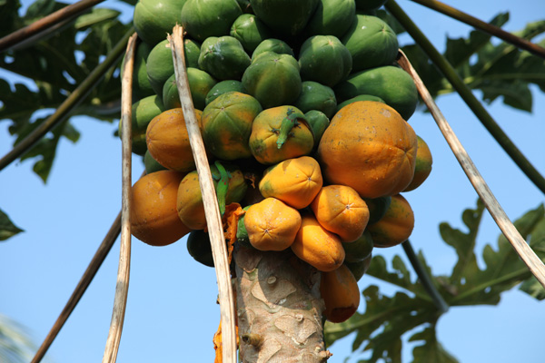
La culture de la papaye est l’un des piliers de l’économie hawaïenne (Photo: C. Grandpey)


