Islande : Comportement stupide sur le site de l’ éruption // Iceland : Stupid behaviour on the eruption site

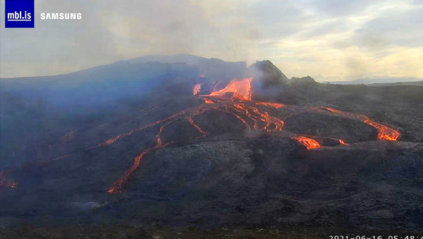
Malgré les mises en garde répétées de la police et des secouristes, de nombreux visiteurs – probablement des touristes étrangers – s’aventurent sur le champ de lave produit par l’éruption de Fagradalsfjall. Certaines personnes ont été repérés sur les images de l’une des webcams en train de déambuler sur la lave à peine solidifiée :

https://icelandmonitor.mbl.is/a/img/monitor/bg/bg_fafaf7_1026x1.png

Une grande partie de la lave de l’éruption de Fagradalsfjall circule actuellement dans des tunnels. S’aventurer sur le champ de lave peut vite virer au drame si le toit d’un tunnel s’effondre sous le poids d’une personne. C’est une mort atroce certaine dans la rivière de lave qui coule sous la croûte.

Les secouristes islandais insistent sur le fait qu’ils n’iront pas aider ces personnes si elles rencontrent des problèmes car ils n’ont aucune envie de mettre leur propre vie en danger.

Un tel comportement inconscient sur les volcans n’est pas exceptionnel. En Islande, certains touristes finissent leurs vacances à l’hôpital parce qu’ils se sont éloignés des sentiers balisés sur les zones thermales de Krisuvik ou de Namaskard. La croûte est très fragile dans ces zones et plonger les pieds dans de la boue à 100 degrés n’est pas une expérience très agréable !

Les accidents avec la lave se produisent généralement dans des endroits où elle est très fluide, et donc très chaude. Plusieurs accidents (impliquant certains de mes amis) ont eu lieu sur le Kilauea à Hawaï ou sur Ol Doinyo Lengai en Tanzanie à l’époque où des coulées de lave avançaient sur ces volcans.

Il faut savoir que ces risques ne sont souvent inutiles car il y a très peu de lucarnes sur le champ de lave en Islande, mais la croûte peut être fine en certains endroits. Alors, ne gâchez pas vos vacances par des comportements stupides !

Source : Iceland Monitor.

—————————————–

Despite repeated statements issued by police and rescue workers, numerous visitors – probably foreign tourists – walk on the lava field created by the Fagradalsfjall eruption. Some were spotted on video recorded by one of the webcams as they were crossing the newly solidified lava (see link above)Lava from the Fagradalsfjall eruption is currently travelling in tunnels. Wlking on the lava field can turn into drama if the roof of a tunnel collapses under the weight of a person who would be sure to die atrociously in the lava river flowing beneat the crust.

Icelandic rescuers insist that will not go and rescue these people if they encounter problems as they do not want tu put their lives at stake.

Such unconscious behaviour on volcanoes is not exceptional. In iceland, some tourists end up their holidays in hospital because they walked away from the marked footpaths in the Krisuvik or Namaskard thermal areas. The earth’s crust is very fragile in these areas and plunging one’s feet in 100-degree mud is not a very pleasant experience !

Accidents with the lava usually occur in places where lava is very fluid, and so very hot. Several accidents (with several friends of mine) were reported on Kilauea Volcano in Hawaii or on Ol Doinyo Lengai in Tanzania when lava flows were observed on these volcanoes.

It should be known that these risks often amount to nothing as there are very few skylights on the lava flield in Iceland, but thr crust can be thin in many places. So, please, don’t ruin your holidays by being stupid !

Source : Iceland Monitor.

Le Nyiragongo après l’éruption // Nyiragongo Volcano after the eruption

Outre Manche, The Guardian est un peu l’équivalent de notre Paris Match : le poids des mots, le choc des photos ! C’est dans cet esprit que le journal britannique a publié une intéressante galerie de photos du Nyiragongo, dans le sillage de l’éruption du 22 mai 2021. Une équipe de scientifiques de l’Observatoire de Goma, accompagnée de rangers armés pour des raisons de sécurité, a escaladé le volcan pour aller observer le cratère. Les photos ne montrent pas le fond du cratère, mais il semble évident que le lac de lave a disparu, suite à sa vidange de la fin mai. L’auteur de l’article nous indique que « le cratère émet une sorte de grondement basse fréquence ponctué d’explosions. De nuit, on observe des restes de lave incandescente au fond du cratère. »

https://www.theguardian.com/world/gallery/2021/jun/15/taking-the-pulse-of-dr-congos-nyiragongo-volcano-in-pictures

————————————-

Across the Channel, The Guardian is a bit like our Paris Match: the weight of words, the shock of photos! It was with this state of mind that the British newspaper published an interesting photo gallery of Nyiragongo, in the wake of the eruption of May 22nd, 2021. A team of scientists from the Goma Observatory accompanied by armed rangers for seacurity reasons, climbed the volcano to observe the crater. The photos do not show the bottom of the crater, but it seems obvious that the lava lake has disappeared, following its drainage in late May. The author of the article tells us that « the crater emits a sort of low-frequency growl punctuated by explosions. At night, residues of glowing lava can be seenat the bottom. »

https://www.theguardian.com/world/gallery/2021/jun/15/taking-the-pulse-of-dr-congos-nyiragongo-volcano-in-pictures

Il faudra attendre probablement plusieurs mois avant que le rougeoiement du lac de lave illumine à nouveau le ciel au-dessus du cratère du Nyiragongo (Crédit photo: Wikipedia)

Dernières nouvelles d’Islande // Latest news from Iceland

La lave coule maintenant dans la vallée de Nátthagi et a recouvert le sentier A qui menait au point de vue sur l’éruption. Le sentier B reste ouvert, mais il est plus long et plus difficile que l’était le sentier A. En revanche, on peut voir la lave avancer dans la vallée de Nátthagi qui est facile d’accès, mais qui ne permet pas de voir le cratère actif. La police craint que certaines personnes qui vont emprunter le sentier B rencontrent des difficultés, se blessent et doivent appeler les secours d’urgence. Pour éviter une telle situation, un nouveau sentier C est en projet le long de Langihryggur.

Selon les dernières informations fournies par l’Institut des Sciences de la Terre de l’Université d’Islande, le débit éruptif est constant depuis environ six semaines, avec 12 mètres cubes par seconde. Le volume total de lave émise est estimé à environ 60 millions de mètres cubes. Le champ de lave couvre plus de trois kilomètres carrés.

Des travaux sont en cours pour essayer de détourner la lave de la Geldingadalir et s’assurer qu’elle continue de s’écouler dans Nátthagi sans déborder dans Nátthagakriki. Si elle entrait dans la vallée de Nátthagakriki, la lave pourrait suivre plusieurs directions différentes et assez imprévisibles. Une digue de quatre mètres de hauteur est en cours d’édification mais il n’est pas sûr qu’elle pourra arrêter la lave. La précédente initiative plus en amont dans la vallée de Nátthagi n’a pas été couronnée de succès. Les autorités reconnaissent que ce n’est qu’un moyen de gagner du temps. Le but est d’empêcher la lave de s’écouler dans Nátthagakriki, vers le sud ou en direction de la centrale géothermique.

Source : www.ruv.is

———————————-

Lava is now running into Nátthagi and covering the main hiking trail A leading to the viewpoint of the eruption. Hiking trail B is open, though it is a longer and more challenging hike, and people have also been allowed to view the advancing lava in Nátthagi, which is an easy walk, but does not have a view of the crater. The police are worried that the more challenging hike on trail B will see the number of emergency calls go up, and plans are being prepared for a new trail C, along Langihryggur.

According to the latest data from the Earth Sciences Institute at the University of Iceland, lava has been flowing at a steady rate of 12 cubic metres per second for roughly six weeks, for a running total of some 60 million cubic metres so far. The lava field covers more than three square kilometres. 

Work is being done to try and divert the lava from Geldingadalir and make sure it continues flowing into Nátthagi and does not run over into Nátthagakriki. From Nátthagakriki, the lava could flow in several different, and less predictable, directions.

A four-metre diversion barrier is being built but it is not sure it will be efficient to stop the lava. The previous similar wall at the top of Nátthagi did not prove successful. Officials admit it is just a means to save time. The goal is to prevent lava from flowing into Nátthagakriki, to the south or in the direction of the geothermal plant.

Source: www.ruv.is


Après quelques journées plus calmes, la lave s’écoule à nouveau en abondance…

Islande : la lave n’a pas (encore) coupé la route côtière // Iceland : lava has not (yet) crossed the coastal road

7 heures : Comme je l’écrivais dans ma dernière note consacrée à l’éruption islandaise, l’information selon laquelle la route côtière aurait été coupée par la lave demandait confirmation. Pour le moment, il n’en est rien, comme on pouvait le voir hier soir les images de la webcam braquée vers la Meradalir.

Il semble qu’il y ait eu une confusion entre les mots « route » et « sentier » car la lave a effectivement recouvert le sentier A. L’éruption reste intense, avec des multiples coulées de surface, en sachant que la lave s’écoule aussi en tunnels.

°°°°°°°°°°

14 heures : Les médias islandais confirment ce que j’ai écrit ce matin. Suite à une hausse du débit éruptif, la lave émise par l’éruption a recouvert le sentier principal (Sentier A) vers 09h00 le 13 juin 2021 et a atteint la vallée de Nátthagi. Suite à cet événement, les autorités ont immédiatement fermé l’accès au volcan et effectué des recherches en hélicoptère pour s’assurer qu’aucune personne n’avait été bloquée. Heureusement, il n’est fait état d’aucun problème. En fonction du débit éruptif, la lave peut maintenant s’écouler de la Meradalir vers la Nátthagi et recouvrir le sentier en d’autres endroits. En conséquence, des travaux sont en cours pour élargir et améliorer le sentier B, comme cela avait été fait pour le sentier A. Si la lave décide de couler dans la vallée de Nátthaga, elle pourrait aussi recouvrir les deux sentiers à l’endroit où ils se séparent. Un troisième sentier serait alors nécessaire pour permettre un accès à l’éruption.

Pour résumer, le site SafeTravel.is explique que pour le moment, le sentier A est fermé. Le sentier B est ouvert mais il est plus long et plus difficile à parcourir que le sentier A. De bonnes chaussures et des bâtons de marche sont indispensables. La plupart du temps, il faut entre 3 à 4 heures pour parcourir le sentier (aller-retour) depuis le point de départ au niveau de la route.

°°°°°°°°°°

18 heures : A noter que ces dernières heures l’éruption semble avoir perdu de sa vigueur et le tremor réagit dans ce sens. On observe un abondant dégazage au niveau du cratère actif. Toute prévision serait hasardeuse. Il se peut que l’on se dirige vers la fin d l’éruption, mais il se peut aussi que l’éruption soit en train de reprendre son souffle et reparte de plus belle ensuite.

°°°°°°°°°°

20 heures : Les images fournies par l’une des webcams apportent des explications à l’évolution de l’éruption qui ne semble pas avoir perdu de sa vigueur si l’on en juge par les vagues qui secouent le lac de lave dans le cratère où le dégazage est impressionnant.. Il y a probablement eu des modifications dans le ou les conduits d’alimentation de l’éruption, avec un apport de lave plus large. En plus du lac, cette lave continue à s’écouler vers l’aval, majpritairement en tunnels. Une partie circule néanmoins en surface et certaines coulées avancent dans la vallée de Natthagha.

———————————-

7:00 am : As I put it in my last post about the Icelandic eruption, the information that the coastal road had been cut by lava needed confirmation. For the moment, has not, as could be seen last night on the images of the webcam aimed at Meradalir. There seems to have been some confusion between the words « road » and « trail » because lava did cover footpath A. The eruption remains intense, with multiple surface flows, and more lava flowing in tunnels.

°°°°°°°°°°

2:00 pm : The Icelandic news media are now confirming what I wrote this morning. Lava from the eruption ran over the main hiking trail (Trail A) at around 09.00 on June 13th, 2021 and travelled down into Nátthagi. The lava flowed over the path from the bottom of Geldingadalir after an increase in the flow rate.

Authorities responded to the breach of the path by closing access to the volcano and launching a helicopter search for anybody who might have become stranded. Fortunarely,nobody was found. .

Depending on the flow rate, lava may now flow from Meradalir into Nátthagi and run over the path in other locations. As a consequence, work is underway to expand and improve hiking trail B to the same standard as trail A was. If lava flows down Nátthaga, however, it could cover both paths at the point at which they separate. Then a third new path would be required to ensure access to the eruption.

To sum it up, the website SafeTravel.is explains that for the time being, Trail A is closed. Trail B is open but it is longer and more difficult to walk than Trail A. Good shoes and hiking poles are essential. Most people need 3-4 hours to walk the trail (return trip) from the starting point by the road.

°°°°°°°°°°

18:00 : It should be noted that in the past hours there has been a decline in the eruption, confirmed by the eruptive tremor. There is a lot of degassing at the active vent. No prediction is possible. The eruption may be coming to an end, but this can only be a pause, and it may start again with a new vigour later on.

°°°°°°°°°°

20:00 : The images provided by one of the webcams allow to better understand the evolution of the eruption which does not seem to have much declined, judging from the huge wave in the lava lake. where degassing is quite impressive. Changes probably occurred in the supply conduits of the eruption, with a wider lava supply. Beside the lake, lava keeps travelling downslope, mostly in tunnels, although surface flows can be seen in the Natthagha valley.