Retour au calme sur le Stromboli (Sicile) // Situation back to normal on Stromboli (Sicily)

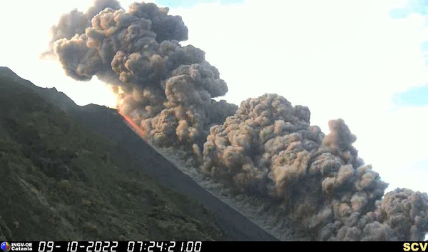
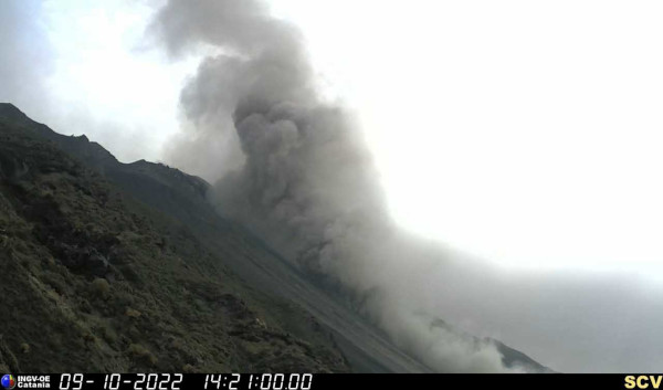
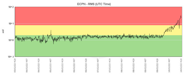
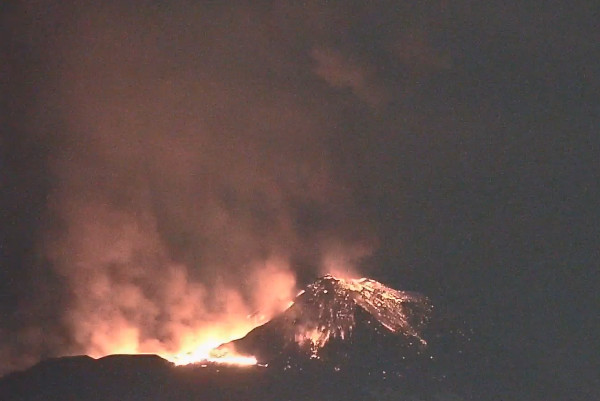
Comme le montre le tracé sismique ci-dessous, on observe en ce moment un retour au calme sur le Stromboli après l’événement du 9 octobre 2022. Plus qu’une intensification de l’activité explosive – qui n’apparaît pas sur les sismos – on a assisté à un effondrement partiel de la terrasse cratèrique nord.

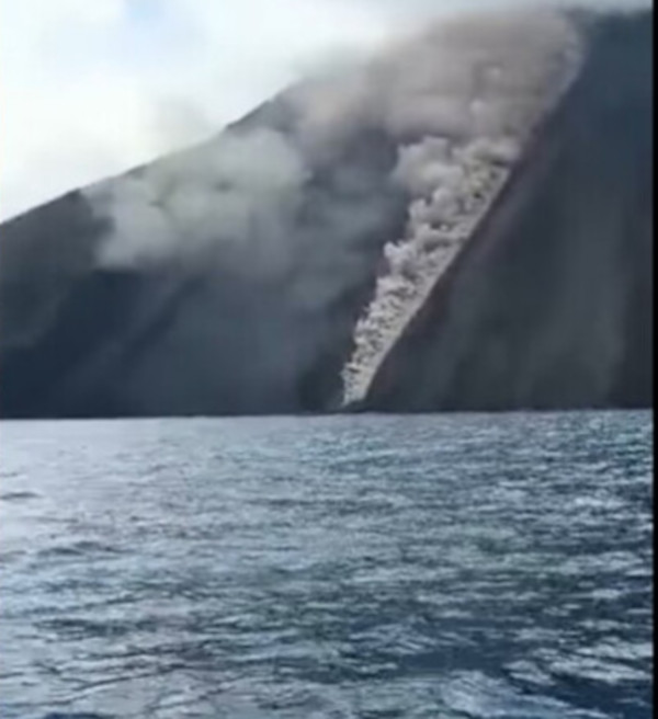
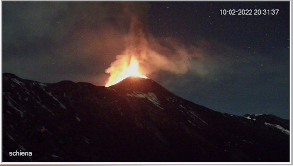
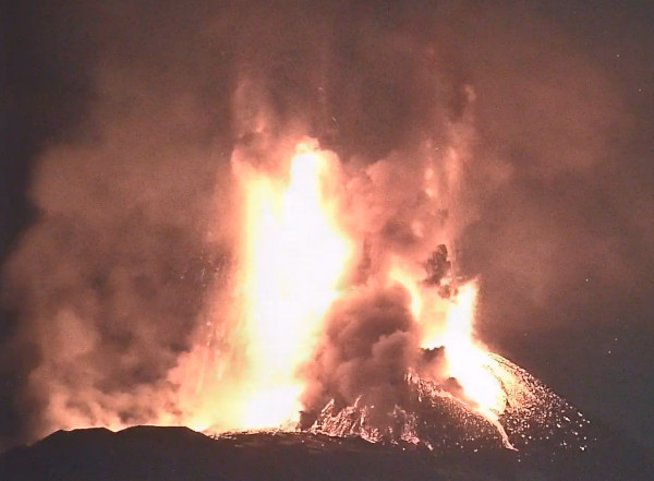
Dans un premier temps, cet effondrement a généré une coulée pyroclastique très spectaculaire avec une importante quantité de matériaux qui a dévalé le long de la Sciara del Fuoco avant d’atteindre la mer où l’impact a provoqué un mini tsunami.

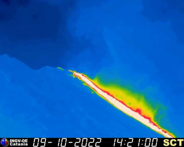
Cette évacuation de matériaux a été suivie d’une coulée de lave qui a emprunté le chenal tracé par la coulée pyroclastique.

Plusieurs vidéos réalisées à l’aide de drones et diffusées sur les réseaux sociaux ont permis de comprendre le déroulement de la situation.

Ce n’est pas la première fois qu’un effondrement se produit au niveau des cratères et entraîne le déferlement d’une importante quantité de matériaux. Ces derniers s’accumulent au pied de la Sciara del Fuoco, en majeure partie sous le niveau de la mer. La répétition de tels événements peut entraîner une déstabilisation et l’effondrement de la masse de matériaux accumulés en profondeur, en générant un tsunami, comme cela s’est produit, par exemple, à la fin de l’année 2002, avec des dégâts causés aux habitations sur le littoral.

A noter que les derniers événements n’ont pas changé les modalités d’accès au volcan: jusqu’à 290 m d’altitude librement et jusqu’à 400 m avec accompagnement obligatoire des guides.

—————————————-

As shown in the seismic plot below, the situation is back to normal on Stromboli after the event of October 9th, 2022. More than an intensification of explosive activity – which does not appear on the seismographs – there was a partial collapse of the northern crater terrace.
Initially, this collapse generated a very spectacular pyroclastic flow with a large quantity of material which tumbled down the Sciara del Fuoco before reaching the sea where the impact caused a mini tsunami.
This evacuation of materials was followed by a lava flow which travelled along the channel dug by the pyroclastic flow.
Several videos made using drones and released on social networks have made it possible to understand the unfolding of the situation.
This is not the first time that a collapse has occurred at the craters and caused the surge of a large quantity of material. These accumulate at the foot of the Sciara del Fuoco, mostly below sea level. The repetition of such events can lead to the destabilization and the collapse of the mass of materials accumulated at depth, generating a tsunami, as happened, for example, at the end of 2002, with damage to homes on the coast.

It should be noted that the latest events have not changed the access rules to the volcano: up to 290 freely and up to 400 m with the compulsory accompaniement of the guides.

Source: LGS

Nouvelle hausse d’activité du Stromboli (Sicile) // New increase in activity of Stromboli (Sicily)

L’INGV indique qu’une succession de coulées pyroclastiques a été observée en début de matinée le 9 octobre 2022 sur le Stromboli. Par la suite, une coulée de lave bien alimentée a atteint la côte après avoir dévalé la Sciara del Fuoco. L’événement a été très spectaculaire, comme on peut le voir sur les vidéos ci-dessous :

L’activité explosive ne montre pas de variations importantes. Du point de vue sismique, à partir de 06:24 (UTC), en relation avec les coulées pyroclastiques, on a observé une augmentation de l’amplitude du tremor qui a atteint un niveau élevé avant de retrouver un niveau moyen.. Il n’y a pas de déformation significative de l’édifice volcanique.

Source: INGV.

Dernière minute : La Protection Civile a ordonné le passage du niveau d’alerte du Stromboli de jaune à Orange suite à une réunion avec les instances scientifiques. Le déclenchement de ce nouveau niveau d’alerte suppose le renforcement du système de surveillance du volcan et du lien d’information entre la communauté scientifique et les structures opérationnelles du Service National de la Protection Civile. La population de l’île est invitée à se tenir informée et à suivre strictement les indications fournies par les autorités locales de Protection Civile.
La réunion mentionnée ci-dessus a été convoquée « à la lumière de l’activité volcanique actuelle, avec le début d’une phase éruptive avec coulée pyroclastique émise depuis la zone du cratère Nord qui a rapidement parcouru la Sciara del Fuoco pour atteindre la mer, générant un effondrement de la terrasse cratèrique, suivi d’un remarquable débordement de lave ».

—————————————-

INGV indicates that several pyroclastic flows were observed in the early morning of October 9th, 2022 on Stromboli. Subsequently, a well-fed lava flow reached the coast after travelling down the Sciara del Fuoco.The event was very spectacular, as can be seen on the videos above.

The explosive activity does not show significant variations. From a seismic point of view, from 06:24 (UTC), in relation to the pyroclastic flows, an increase in the amplitude of the tremor was observed. It reached a high level before returning to an average level. There is no significant deformation of the volcanic edifice.

Source: INGV.

Last minute: The Civil Protection has raised the alert level for Stromboli from yellow to Orange following a meeting with the scientific authorities. The triggering of this new alert level includes the strengthening of the volcano monitoring system and the information link between the scientific community and the operational structures of the Civil Protection Service. The population of the island is invited to keep informed and to strictly follow the indications provided by the local Civil Protection authorities.
The aforementioned meeting was convened « in light of the current volcanic activity, with the beginning of an eruptive phase with pyroclastic flow emitted from the area of ​​the North crater that quickly travelled the Sciara del Fuoco to reach the sea , generating a collapse of the crater terrace, followed by a remarkable lava overflow ».

Source: INGV

Une coulée de lave de 75 km ! // A 75-kilometer-long lava flow !

La NASA a réussi à capturer dans sa totalité le Carrizozo Malpaís, une formation de lave longue de… 75 kilomètres. Sa largeur varie de 1 kilomètre dans sa partie la plus étroite à 5 kilomètres au niveau des extrémités. L’Administration a dû assembler quatre clichés pour capturer la coulée dans toute son ampleur. Les photos ont été réalisées depuis la Station spatiale internationale (ISS). Sur le montage final, on peut voir le Carrizozo Malpaís, une grande coulée de lave basaltique au Nouveau-Mexique.

Les différents clichés, pris le 30 juin 2022, couvrent les quelque 33.700 hectares et 75 kilomètres de long de la formation. Selon l’USGS, cette coulée de lave, en plein cœur du désert de Chihuahua, a été produite en une seule fois par une éruption il y a environ 5200 ans; elle aurait duré entre 20 et 30 ans. La source est un cône de 27 mètres de hauteur que les locaux appellent «Little Black Peak. Il est l’un des points culminants d’un volcan bouclier aujourd’hui inactif. L’USGS explique que « la coulée est l’une des plus longues connues à avoir surgi sur Terre au cours des 10 000 dernières années. » Sa composition lui a permis d’avancer facilement dans le Tularosa Basin. Une autre coulée, moins visible dans le paysage, a été émise par le Broken Back Crater au nord.

Connu depuis longtemps, le Carrizozo Malpaís n’avait pas pu être capturé dans sa totalité et en détail. Les derniers clichés constituent les images aériennes les plus détaillées jamais prises de la coulée de lave. Contrairement à ce que l’on pourrait penser en regardant la couleur très sombre de la lave, elle n’est pas dépourvue de vie. Un certain nombre d’espèces de plantes, caractéristiques des milieux désertiques, comme le figuier de Barbarie ou encore le genévrier, ont élu domicile sur la coulée.

Source: NASA.

——————————————

NASA has managed to capture the Carrizozo Malpaís in its entirety, a lava formation 75 kilometers long. Its width varies from 1 kilometer in its narrowest part to 5 kilometers at the extremities. The Administration had to put together four shots to capture the full extent of the flow. The photos were taken from the International Space Station (ISS). On the final montage, one can see the Carrizozo Malpaís, a large basaltic lava flow in New Mexico.
The various shots, taken on June 30th, 2022, cover the approximately 33,700 hectares and 75 kilometers long of the formation. According to USGS, this lava flow, in the heart of the Chihuahua Desert, was produced in one go by an eruption about 5200 years ago; it probably lasted between 20 and 30 years. The source was a 27 meter tall cone that locals call “Little Black Peak. It is one of the highest points of a now inactive shield volcano. USGS explains that « the flow is one of the longest known on Earth in the past 10,000 years. » Its composition allowed it to easily advance in the Tularosa Basin. Another flow, less visible in the landscape, was emitted from the Broken Back Crater to the north.
Known for a long time, the Carrizozo Malpaís could not be captured in its entirety and in detail. The latest snaps are the most detailed aerial images ever taken of the lava flow. Contrary to what one might think looking at the very dark color of the lava, it is not devoid of life. A number of plant species, characteristic of desert environments, such as the prickly pear or even the juniper, have taken up residence on the lava flow.
Source: NASA.

Source: NASA

Etna (Sicile) : activité éruptive au Cratère Sud-Est // Eruptive activity at the South-East Crater

Depuis plusieurs heures ce 10 février 2022, le Cratère Sud-Est (CSE) de l’Etna connaît un net regain d’activité.

Dans un premier bulletin diffusé à 5 heures (heure locale), l’INGV indique qu’au cours de la nuit, on observait la reprise d’une activité explosive relativement modeste au niveau du Cratère Sud.L’activité restait confinée à l’intérieur du cratère et génèrait des émissions discontinues de cendres. Dans le même temps, on observait une hausse de l’amplitude moyenne du tremor.

A 16 heures, un modeste débordement de lave était observé depuis le cratère Sud-Est, dans une direction Ouest – Sud-Ouest. Du point de vue sismique, la phase d’augmentation de l’amplitude du tremor se poursuivait. .
Les réseaux de surveillance ne détectait aucune déformation significative du sol.

A partir d’environ 18 heures, il y a eu une intensification marquée de l’activité strombolienne au niveau du CSE. La coulée de lave produite par l’activité en cours semble être encore alimentée et le front a atteint une altitude d’environ 2900 m au-dessus du niveau de la mer.
La hausse du tremor atteint maintenant un niveau élevé.

Depuis 21h40 environ, on observe le passage d’une activité strombolienne à une activité de fontaine de lave. La coulée mentionnée précédemment continue d’être bien alimentée. Le nuage éruptif, d’environ 10000 m de hauteur, se dirige vers le secteur ouest du volcan. L’amplitude du tremor a atteint des valeurs très élevées. La couleur de l’alerte aérienne est passée au Rouge, mais l’aéroport de Catane n’est pas impacté par l’éruption, du moins en ce moment.

Il est 23h15 et la crise éruptive qui a animé le Cratère SE pendant toute la fin de la journée semble en train de se terminer. L’activité strombolienne a pratiquement cessé dans le cratère. La lave continue à être bien présente sur la partie SO du cône, mais son écoulement devrait cesser assez rapidement. La sismicité et le tremor font écho à cette chute d’activité. Cela faisait longtemps que le Cratère SE ne s’était pas manifesté aussi vigoureusement.

Source: INGV.

————————————-

For several hours on February 10th, 2022, Mt Etna’s South-East Crater (SEC) has been experiencing a marked increase in activity.
In a first bulletin issued at 5 a.m. (local time), INGV indicates that during the night, a resumption of relatively modest explosive activity was observed at the South Crater. The activity remained confined to the inside the crater and generated discontinuous ash emissions. At the same time, an increase in the average amplitude of the tremor was observed.

At 4 p.m., a modest lava overflow was observed from the Southeast crater, in a West – Southwest direction. From a seismic point of view, the increase in the amplitude of the tremor continued. .
The monitoring networks did not detect any significant ground deformation.

Starting at about 6 p.m., there was a marked intensification of Strombolian activity at the SEC. The lava flow produced by the ongoing activity appears to be still fed and the front has reached an elevation of approximately 2900m above sea level.
The rise in the tremor is now reaching a high level.
Source: INGV.

Since about 9:40 p.m., a transition from Strombolian activity to lava fountain activity has been observed. The previously mentioned flow continues to be well fed. The eruptive cloud, about 10,000 m high, is spreading towards the western area of the volcano. The amplitude of the tremor has reached very high values. The aviation colour code has been raised to Red but Catania airport is not affected by the eruption, at least for the moment.

It is 11:15 p.m. and the eruptive crisis that shook the SE Crater for the entire end of the day seems to be coming to an end. Strombolian activity has virtually ceased in the crater. Lava continues to be present on the SW part of the cone, but its flow should stop quite quickly. Seismicity and the tremor are responding to this drop in activity. The SE Crater had not been so vigorous for quite a long time..

Source : INGV

L’activité éruptive vue par la webcam de l’association L.A.V.E.

D’autres webcams donnent de bonnes images en streaming, comme celle-ci qui montre que l’activité éruptive reste intense:

https://vedetta.org/fr/webcam/Italie/Sicile/Catane/Volcan-Etna-au-sud-est/

 Fin du spectacle !