Nouvelle éruption à court terme en Islande ? // New eruption in the short term in Iceland ?

Alors que l’éruption qui a débuté le 16 mars 2024 se poursuit à Sundhnúksgígaröð, le Met Office islandais prévient qu’une nouvelle éruption pourrait commencer très prochainement dans la même zone. C’était l’un des scénarios imaginés par les volcanologues islandais il y a quelques jours.
L’activité sismique sur la péninsule de Reykjanes montre qu’une éruption pourrait se produire à tout moment. Les scientifiques pensent qu’elle interviendra plus ou moins dans le même secteur que les éruptions précédentes.
Un soulèvement du sol est de nouveau observé à Svartsengi depuis début avril, signe évident d’une accumulation de magma sous la surface. Le Met Office explique que la hausse a atteint un niveau tel qu’une éruption est désormais possible à tout moment. Cependant, il est peu probable qu’elle se produise ailleurs sur la péninsule. L’éruption pourrait avoir lieu près de Grindavík ou de Svartsengi.

Image webcam de l’éruption le 21 avril 2024 au matin. Les projections sont moins intenses depuis quelques jours dans la bouche active. Pas sûr que le projet d’ouverture du site aux touristes tienne la route si une nouvelle éruption se déclenche…!

——————————————

While the eruption that started on March 16th, 2024 is still going on at Sundhnúksgígaröð, the Icelandic Met Office warns that another eruption might start very soon in the same area. It was one of the scenarios imagned by the Met Office a few days ago.

Seismic activity in Reykjanes is giving every indication that an eruption could occur at any moment. Scientists believe it will go off at roughly the same location as before.

Ground uplift has been again observed at Svartsengi since early April, a typical sign of magma gathering beneath the surface. The Met Office explains that the rising has reached a level where now an eruption is predicted to occur at any moment. However, it is unlikely that it will occur anywhere else but where it already is. As such, it may erupt near Grindavík or Svartsengi.

Islande : soulèvement du sol à Svartsengi et évolution possible de la situation // Iceland : ground uplift at Svartsengi and possible evolution of the situation

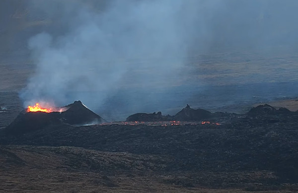
L’éruption qui a débuté le 16 mars 2024 au niveau du cratère Sundhnúkur sur la péninsule de Reykjanes, se poursuit à un rythme constant avec un débit de lave d’un peu plus de 3 mètres cubes par seconde. Depuis le 5 avril, un seul cratère est actif sur la fracture éruptive.
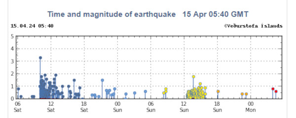
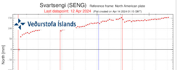
Lorsque l’éruption a commencé en mars, le soulèvement du sol à Svartsengi a considérablement ralenti et s’est presque arrêté. Cela indiquait qu’il existait un équilibre entre l’arrivée de magma dans le réservoir magmatique sous Svartsengi et le débit éruptif au niveau de la chaîne de cratères de Sundhnúkur.
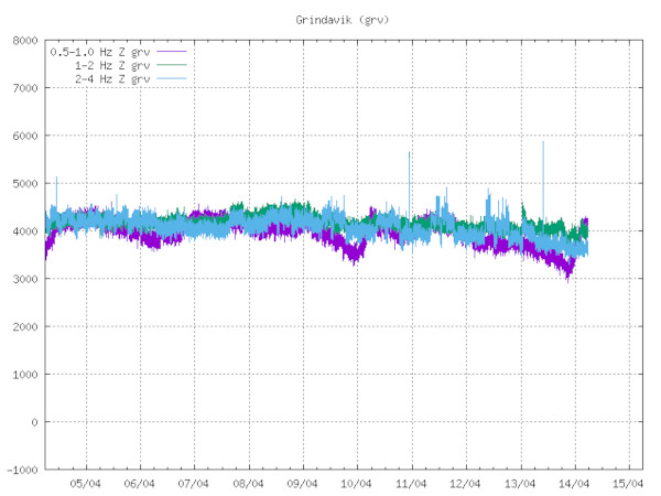
Début avril, le soulèvement du sol a recommencé à augmenter à Svartsengi, et le volume de magma qui s’évacue maintenant à Sundhnúkur est identique à celui qui s’accumule dans le réservoir sous Svartsengi. Cela provoque une augmentation de la pression magmatique et donc un soulèvement du sol.

Soulèvement du sol à Svartsengi (Source: Met Office)

L’évolution actuelle est différente de celle des éruptions passées. Avec l’éruption actuelle, on a un débit de lave relativement stable au niveau du cratère Sundhnúkur et, en même temps, un soulèvement du sol à Svartsengi. On ne sait donc pas comment va évoluer la situation. Aujourd’hui, on ne peut exclure une montée du magma vers la surface avec une activité éruptive qui s’ajouterait à l’éruption en cours.
Si l’accumulation de magma se poursuit au même rythme, la probabilité d’une autre propagation du magma vers la surface augmentera dans les jours ou semaines à venir, même si l’éruption actuelle continue. Une telle situation n’a jusqu’à présent jamais été observée sur la péninsule de Reykjanes.
Dans son dernier rapport, le Met Office envisage plusieurs scénarios si la propagation du magma vers la surface coïncide avec l’éruption actuelle :
1) Le magma pourrait quitter le réservoir magmatique sous Svartsengi et atteindre la chaîne de cratères de Sundhnúkur, comme cela s’est produit au cours des six dernières éruptions.
2) Suite à l’arrivée d’un nouveau magma, de nouvelles fractures éruptives pourraient s’ouvrir dans la zone située entre Stóra-Skógfell et Hagafell et le cratère éruptif actuel pourrait s’agrandir en raison d’une augmentation soudaine du débit de lave.
3) Il est également possible que la propagation du magma vers la surface ne se produise pas, mais que le débit de l’éruption actuelle commence à augmenter régulièrement jusqu’à ce qu’un nouvel équilibre soit atteint entre l’arrivée de magma et le débit éruptif en surface. Cependant, si l’arrivée de magma en surface entraîne l’ouverture d’une nouvelle fracture éruptive ailleurs que dans la zone située entre Stóra-Skógfell et Hagafell, un tel scénario s’accompagnera très probablement d’une sismicité intense et d’une déformation beaucoup plus visible que lors des éruptions précédentes.
Source : Met Office.

Jusqu’à présent, l’accès au site de l’éruption sur la péninsule de Reykjanes était interdit, mais la situation pourrait bientôt changer. L’Office islandais du tourisme a mis en place un groupe de travail chargé de faire le nécessaire pour ceux qui souhaiteraient assister à l’éruption.
L’idée est d’ouvrir une zone près de Svartsengi avec accès par la Grindavíkurvegur du côté est. Des discussions sont en cours avec les propriétaires fonciers et, si elles aboutissent, le groupe de travail prévoit de créer un parking payant pour les visiteurs. C’est une bonne idée, mais l’éruption est beaucoup moins intense qu’il y a quelques semaines.

Source : Iceland Review.

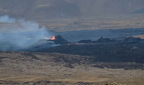
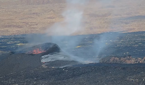
Vue de l’éruption le 19 avril 2024 (image webcam)

———————————————–

The eruption that started on March 16th, 2024 at the Sundhnúkur crater row on the Reykjanes Peninsula is going on at a steady rate with a lava flow just over 3 cubic meters per second. Since April 5th, only one crater has erupted.

When the eruption started in March, ground uplift at Svartsengi slowed down considerably and almost stopped. This indicated an equilibrium between magma inflow into the magma reservoir beneath Svartsengi, and to the surface at the Sundhnúkur crater row.

At the beginning of April, ground uplift began to increase again at Svartsengi, and a similar volume of magma is now being erupted at Sundhnúkur as is accumulated in the reservoir beneath Svartsengi, causing increased magma pressure, and thus ground uplift.

The current development is different from the past eruptions. With the current one, there is a relatively stable lava flow at Sundhnúkur crater row and, at the same time,ground uplift in Svartsengi. Therefore, there is more uncertainty now than before about the possible development of the event. Today, one cannot exclude a magma propagation to the surface during the ongoing eruption.

If magma accumulation continues at a similar rate, the likelihood of another magma propagation increases in the coming days or weeks, even though an eruption is still ongoing. This kind of situation has thus far not been seen before in the area.

In its latest report, the Met Office predicts deveral robable scenarios if magma propagation coincides with the current eruption:

  1. Magma might propagate from the magma reservoir beneath Svartsengi to the Sundhnúkur crater row, as has happened in the last six times.
  2. Following the magma propagation, new eruptive fissures could open in the area between Stóra-Skógfell and Hagafell and the current eruptive crater could be enlarged due to a sudden increase of lava flow.
  3. It is also possible that magma propagation will not occur, but that the flow of the current eruption will begin to increase steadily until a new equilibrium between the inflow of magma from below and flow to the surface from the crater is reached. However, if magma propagation results in a new eruptive fissure opening elsewhere than in the area between Stóra-Skógfell and Hagafell, such a scenario would very likely be accompanied by intense seismicity and deformation with considerably more notice than previous eruptions.

Source : Met Office.

Up to now, access to the eruption site on the Reykjanes Peninsula was prohibited, but the situation might change soon. The Icelandic Tourist Board leads a workgroup that has the task of preparing facilities for those who want to view the volcanic eruption.

The idea is to open an area near Svartsengi with access through Grindavíkurvegur road on the eastern side. Contracts are underway with land owners and if they are completed, the workgroup plans to make a parking space for those who want to witness the eruption. Visitors will be charged for access to the parking space. This is a good idea, but the eruption is far less intense than a few weekks ago.

Source : Iceland Review.

Activité sismique sur la péninsule de Reykjanes (Islande) // Seismic activity on the Reykjanes Peninsula (Iceland)

Un nouveau petit essaim sismique a été enregistrés sous et autour du mont Þorbjörn, sur la péninsule de Reykjanes, dans l’après-midi du 14 avril 2024. Un grand nombre de ces événements étaient alignés sur la fracture éruptive active actuellement. Aucun de ces séismes n’avait une magnitude supérieure à M 2,0, mais c’est la première fois que de petits séismes sont enregistrés sur une période aussi courte depuis le début de l’éruption le 16 mars.
Comme je l’ai écrit précédemment, un essaim sismique avec un événement de M 3,3 a été enregistré le 13 avril dans la région de Krisuvik, avec son épicentre au niveau du lac Kleifarvatn, à une profondeur de 6 km. Le séisme a été ressenti jusque dans la région de Reykjavik et a été suivi de plusieurs répliques.

Source: Met Office

Dans le même temps, dans le secteur de Svartsengi, le soulèvement du sol se poursuit au même rythme qu’au début du mois d’avril. C’est probablement dû au mouvement du magma sous la surface. Cependant, le Met Office indique que cela n’annonce pas forcément une autre éruption.
L’éruption actuelle semble relativement stable.
Source : Met Office, Iceland Review.

Image webcam de l’éruption le 15 avril 2024 au matin

———————————————

A new small seismic swarm was recorded under and around Mt Þorbjörn on the Reykjanes peninsula in the afternoon of April 14th, 2024. A great many of these events are aligning with the ongoing eruption fissure. None of these quakes had a magnitude greater than M 2.0, but it is the first time such small quakes have been recorded over such a short period of time since the start of the eruption on March 16th.

As I put it before, a seismic swarm including an event reaching M 3.3 was recorded on April 13th in the Krisuvik area, with the epicenter at Kleifarvatn lake, at a depth of 6 km. The earthquake was felt well in the capital area andwas followed by several aftershocks.

Meanwhile, ground surface rising has been continuing in the Svartsengi area at the same rate as was recorded in the beginning of April. It is probably an indicator of magma movement beneath the surface. However, the Met Office says it does not necessarily mean the arrival of another eruption.

The current eruption does not appear to be increasing in activity.

Source : Met Office, Iceland Review.

Islande : nouvelles de l’éruption // Iceland : news of the eruption

Dans une mise à jour publiée le 9 avril 2024, le Met Office indiquait que la déformation du sol dans le secteur de Svartsengi continuait d’augmenter, en même temps que l’on observait une diminution de l’intensité de l’éruption, confirmée par le tremor volcanique.

Image webcam de l’éruption le 13 avril 2024

 Tremor éruptif le 14 avril 2024 (Source: Icelandic Met Office)

Le soulèvement du sol à Svartsengi semble assez stable et n’a augmenté que très légèrement ces derniers jours.

Source: Met Office

Selon le Met Office, cette situation montre que la plus grande partie du magma s’accumule dans le réservoir situé sous Svartsengi, avec une pression qui provoque le soulèvement du sol. L’éruption se poursuit avec une connexion ouverte entre la zone d’accumulation du magma sous Svartsengi et la chaîne de cratères de Sundhnúkur. Une partie du magma continue de s’écouler vers la surface tandis que le reste s’accumule sous Svartsengi.

L’activité sismique dans le dyke près de Grindavíkreste très faible et se concentre entre Sýlingarfell et Stóra-Skógafell, avec une légère sismicité à l’ouest de Grindavík. L’activité sismique près du Fagradalsfjall, qui persiste depuis un mois, se poursuit et reste localisée à des profondeurs d’environ 6 à 7 km.
A noter qu’un essaim sismique avec un événement de M 3,3 a été enregistré le 13 avril dans la région de Krisuvik, avec son épicentre au niveau du lac Kleifarvatn, à une profondeur de 6 km. Le séisme a été bien ressenti jusque dans la région de Reykjavik et a été suivi de plusieurs répliques.

Des niveaux élevés de SO2 continuent d’être mesurés périodiquement autour du site éruptif et dans les zones habitées de la péninsule de Reykjanes. Les émissions de gaz provenant de l’éruption continueront probablement de générer une pollution sur la péninsule de Reykjanes. Il est conseillé à la population de surveiller la qualité de l’air et de s’informer sur les symptômes liés à la pollution atmosphérique provoquée par l’éruption.

————————————————

In an update released on April 9th, 2024, the Met Office indicated that ground deformation in the Svartsengi area continued to increase, coinciding with a decrease in the intensity of the volcanic eruption, also shown by the volcanic tremor.

Inflation at Svartsengi looks quite stable and has been increasing only very slightly in the past days.

According to the Met Office, this indicates that the majority of the magma flowing into the reservoir beneath Svartsengi is accumulating there, causing an increase in pressure and ground uplift. While the eruption continues, there remains an open connection between the magma accumulation area in Svartsengi and the Sundhnúkur crater row.A portion of the magma continues to flow to the surface whereas the rest accumulates beneath Svartsengi.

Seismic activity in the dike near Grindavík has remained very low and is focused between Sýlingarfell and Stóra-Skógafell, with slight seismicity in western Grindavík. Seismic activity near Fagradalsfjall, which has been persistent for the past month, is ongoing and remains localized at depths of about 6-7 km.

It should be noted that a seismic swarm with an event reaching M 3.3 was recorded on April 13th in the Krisuvik area, with the epicenter at Kleifarvatn lake, at a depth of 6 km. The earthquake was felt well in the capital area andwas followed by several aftershocks.

Periodically high levels of SO2 continue to be measured around the volcano and in settlements on the Reykjanes Peninsula. Gas emissions from the eruption will likely cause pollution on the Reykjanes Peninsula, and residents are advised to monitor air quality and familiarize themselves with symptoms related to air pollution from the eruption.