Un nouveau séisme, d’une magnitude M 4,2, a été enregistré sur la péninsule de Reykjanes le 30 octobre 2023 à 12h19. L’hypocentre a été localisé à 6 km de profondeur. Il a été ressenti en de nombreux endroits, y compris dans la région de Reykjavik. L’épicentre se trouvait à Sýlingarfell, à environ trois kilomètres à l’est du Blue Lagoon, et donc pas très loin de la centrale électrique de Svartsengi. La sismicité est irrégulière sur la péninsule mais a diminué depuis l’essaim observé ces derniers jours.
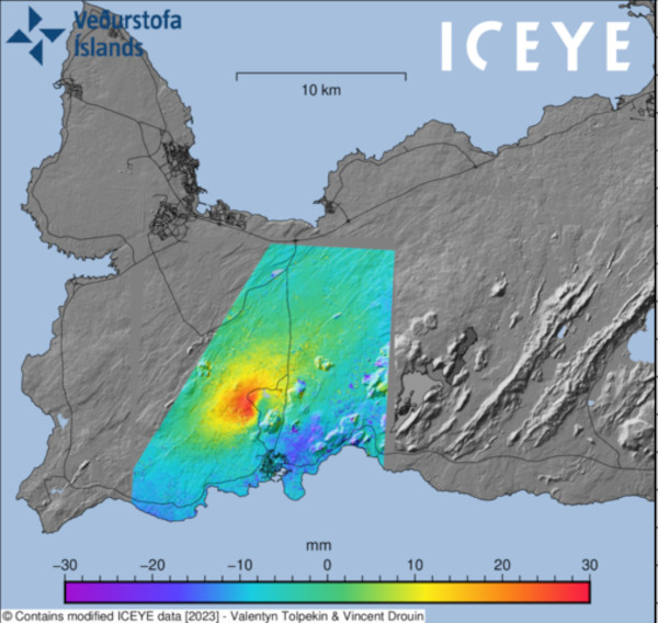
Le dernier séisme survient après l’annonce selon laquelle la terre est en train de se soulever au nord-ouest de Þorbjörn, bien à l’ouest de Fagradalsfjall. et à proximité du Blue Lagoon, de Svartsengi et de Grindavík. Selon un volcanologue islandais, il ne serait pas surprenant qu’il faille procéder à une évacuation et il faudrait faire vite.
Le soulèvement du sol a été assez rapide, trois centimètres en 24 heures. La terre s’est soulevée cinq fois dans la région depuis 2020, mais la vitesse de soulèvement des derniers jours est plus grande que les fois précédentes.
La grande question est de savoir ce qui pourrait être fait pour protéger les structures sous la menace d’une éruption. La centrale électrique de Svartsengi n’est pas loin de cette zone et alimente toute la péninsule de Reykjanes. Le Blue Lagoon n’est pas loin, non plus, du secteur où la terre se soulève. Grindavik.
Comme je l’ai expliqué précédemment, le contexte volcano-tectonique de la Péninsule de Reykjanes et personne ne sait si, quand et où une éruption pourrait avoir lieu.
Dernière minute : Les dernières mesures révèlent que la nouvelle intrusion magmatique se situe juste au nord-ouest de la ville de Grindavík, à proximité de Þorbjörn et du Blue Lagoon. Si une éruption devait se produire, cela pourrait sêtre près du mont Þorbjörn aou du Fagradalsfjall, la zone où se sont produites les trois dernières éruptions sur la péninsuke de Reykjanes.
————————————————–
 Another strong earthquake with a magnitude M 4.2 hit the Reykjanes peninsula at 12.19 on October 30th, 2023, at a depth of 6 km. It was felt in many places, including in the capital area. The epicenter of the earthquake was at Sýlingarfell, about three kilometers east of the Blue Lagoon, and therefore closer to the power plant in Svartsengi. Seismicity is irregular on the peninsula but has decreased since the swarm observed in the past days.
The earthquake comes after the news that the land has been rising northwest of Þorbjörn, considerably west of Fagradalsfjall. close to the Blue Lagoon, Svartsengi and Grindavík. An Icelandic volcanologist warns that it would not be surprising if there were to be an evacuation and that the response time would be low.
The land rise has been quite fast, three centimeters in 24 hours.. Land has risen in the area five times since 2020, but the speed is now considerably higher than in the previous times.
The big question is what could be done to protect the structures that would be under the threat of an eruption. The power plant in Svartsengi is not far from this area and it powers the whole of the Reykjanes peninsula. Furthermore the Blue Lagoon is not far from the center of the land rising. Without forgetting Grindavik.
As I explained previously, the volcano-tectonic setting of the Reykjanes Peninsula is very complex and no one knows if, when and where an eruption could take place.
Last minute : The latest measurements reveal that the new magma intrusion is just northwest of the town of Grindavík, close to Þorbjörn mountain and the Blue Lagoon. Should an eruption occur, it might be by Þorbjörn Mountain as well as by Fagradalsfjall, the area where the last three eruptions on Reykjanes occurred.

Source: IMO