Entre Hawaii et la Lune… // From Hawaii to the Moon…

drapeau francaisDans les années 70, Hawaï a joué un rôle important dans la préparation des astronautes pour leurs missions spatiales. Dans la mesure où le terrain volcanique de la Grande Ile présente une forte ressemblance avec le sol de la Lune, il a constitué un terrain d’entraînement idéal pour les équipages des misions Apollo.
En décembre 2013, Bob Kelso, Directeur du Centre Spatial International du Pacifique pour les Systèmes d’Exploration (PISCES), a eu pour mission de rechercher des photos documentant le rôle d’Hawaii en vue de l’envoi d’astronautes sur la Lune. Il a passé au crible de nombreux négatifs dans les archives de photos de la NASA au Johnson Space Center à Houston (Texas) et a trouvé les photos extraordinaires présentées sur cette page Web :
http://www.pacificspacecenter.com/rare-nasa-photos-of-apollo-astronauts-training-in-hawaii/?show=gallery

Les photos montrent les astronautes en train de tester des équipements pour des missions lunaires et de futurs atterrissages sur la planète Mars. Le Johnson Space Center a travaillé sur la confection de deux présentations murales des photos  L’une de ces présentations peut être admirée au bureau du PISCES à Hilo

 ——————————————-

drapeau anglaisIn the seventies, Hawaii played a significant part in preparing the astronauts for their space missions. Because the Big Island’s volcanic terrain has a strong resemblance to the terrain on the Moon, it made for an ideal training ground for Apollo crews.

Last December, Pacific International Space Center for Exploration Systems (PISCES) Executive Director Rob Kelso went on a mission to search for photos documenting Hawaii’s role in helping send the astronauts to the surface of the Moon. He sifted through numerous negatives in NASA’s photo archive at Johnson Space Center in Houston, Texas, and found the extraordinary pictures displayed on this web page:

http://www.pacificspacecenter.com/rare-nasa-photos-of-apollo-astronauts-training-in-hawaii/?show=gallery

The photos show a variety of situations where astronauts are seen testing equipment for upcoming lunar missions and future landings on Mars. The Center has been working on putting together two murals displaying the pictures. One is now hanging at the PISCES office in Hilo.

Hawaii NASA

Crédit photo:  NASA.

52 volcans des Aléoutiennes sur la même photo! // 52 Aleutian volcanoes on the same photo!

drapeau francaisLe 16 mai 2014, le satellite Aqua de la NASA réussissait à réunir sur un même clicjé 52 volcans actifs des Iles Aléoutiennes ! C’est exceptionnel car la couverture nuageuse est en général fort importante dans cette partie du monde. La situation volcanique est en cemoment globalement calme, exception faite du Shishaldin qui montrait quelques signes de réveil il y a quelques jours (voir ma note du 14 mai).

Erik Klemetti, professeur de Sciences de la Terre à l’Université Denison, a indiqué le nom de tous ces volcans avec des couleurs correspondant à leur niveau d’alerte, informations que vous trouverez sur le site web de l’Alaska Volcano Observatory :

http://www.wired.com/wp-content/uploads/2014/05/AleutianIslands_Volcanoes_lg_30.jpg

 ———————————————

drapeau anglaisOn May 16th 2014, NASA’s Aqua satellite managed to catch in one shot 52 volcanoes of the Aleutian Islands! This is exceptional as the sky is mostly cloudy in that part of the world. The situation is globally quiet, except for Shishldin that showed some signs of awakening a few weeks ago (see my post of May 14th).

Erik Klemetti, an assistant professor of Geosciences at Denison University, has colour-coded the names of the volcanoes on the image according to their official activity status to be found on the Alaska Volcano Observatory website:

http://www.wired.com/wp-content/uploads/2014/05/AleutianIslands_Volcanoes_lg_30.jpg

Le Pavlof (Iles Aléoutiennes) il y a un an… // Pavlof volcano one year ago…

drapeau francaisIl y a un an, le 13 mai 2013, le Pavlof entrait en éruption. Quelques jours plus tard, l’ISS survolait la région et la NASA mettait en ligne le 18 mai plusieurs images spectaculaires de cet événement. Vous les découvrirez en cliquant sur ce lien :

http://earthobservatory.nasa.gov/IOTD/view.php?id=81205&eocn=home&eoci=iotd_grid

 ———————————————-

drapeau anglaisOne year ago, on May 13th 2013, an eruption was beginning on Pavlof volcano. A few days later, the ISS was flying over the region and NASA released a few dramatic images of the event. Just click on this link to see them:

http://earthobservatory.nasa.gov/IOTD/view.php?id=81205&eocn=home&eoci=iotd_grid

Iles Sandwich du Sud // South Sandwich Islands

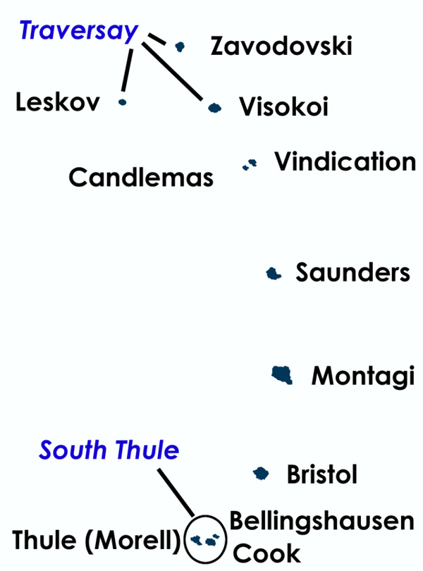
drapeau francaisLes îles Sandwich du Sud ne sont pas l’endroit le plus connu de la planète. Situé dans le sud de l’Océan Atlantique, entre l’Amérique du Sud et l’Antarctique, ce territoire britannique d’outre-mer est d’origine volcanique et forme un arc de 11 îles inhabitées s’étirant sur 390 kilomètres du nord au sud. Il est le résultat de la subduction de la plaque Scotia, sur laquelle elles reposent, sous la plaque africaine.

Iles-Sandwich-01

L’intérieur des îles est particulièrement inhospitalier. Il est constitué de montagnes culminant parfois à plus de 1 000 mètres d’altitude et recouvertes de glaciers à 80 %.

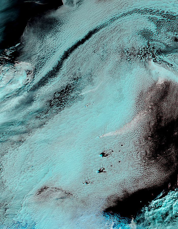
Les Iles Sandwich du Sud disparaissent souvent sous une couche nuageuse qui rend leur observation très difficile. La NASA a parfois recours à des images aux couleurs fausses pour discerner ce qui se passe sous les nuages. C’est ainsi que le 19 avril dernier le spectroradiomètre MODIS embarqué à bord du satellite Aqua a permis de réaliser cette image surprenante que vous pourrez voir en plus haute résolution en cliquant sur ce lien :

http://modis.gsfc.nasa.gov/gallery/images/image04302014_1km.jpg

 Iles-Sandwich-02

Les îles proprement dites apparaissent en couleur turquoise vive sur l’image, tandis que les nuages sont en turquoise claire et l’eau de l’océan en noir. Le panache volcanique que l’on voit dans la partie septentrionale de l’image est de couleur blanche. Il s’échappe d’un volcan de l’île Zavodovski avant de s’étirer vers le NE. Plus au sud, on distingue le panache plus large en provenance d’un autre volcan, le Mount Michael, situé sur l’île Saunders dans la partie centrale de l’arc volcanique. Le panache se dirige lui aussi vers le NE en formant une série de tourbillons. Encore plus au sud, on aperçoit d’autres remous derrière trois autres îles. C’est ce qu’on appelle les allées de tourbillons de Karman, causées par la séparation instable d’un écoulement autour de corps peu profilés.

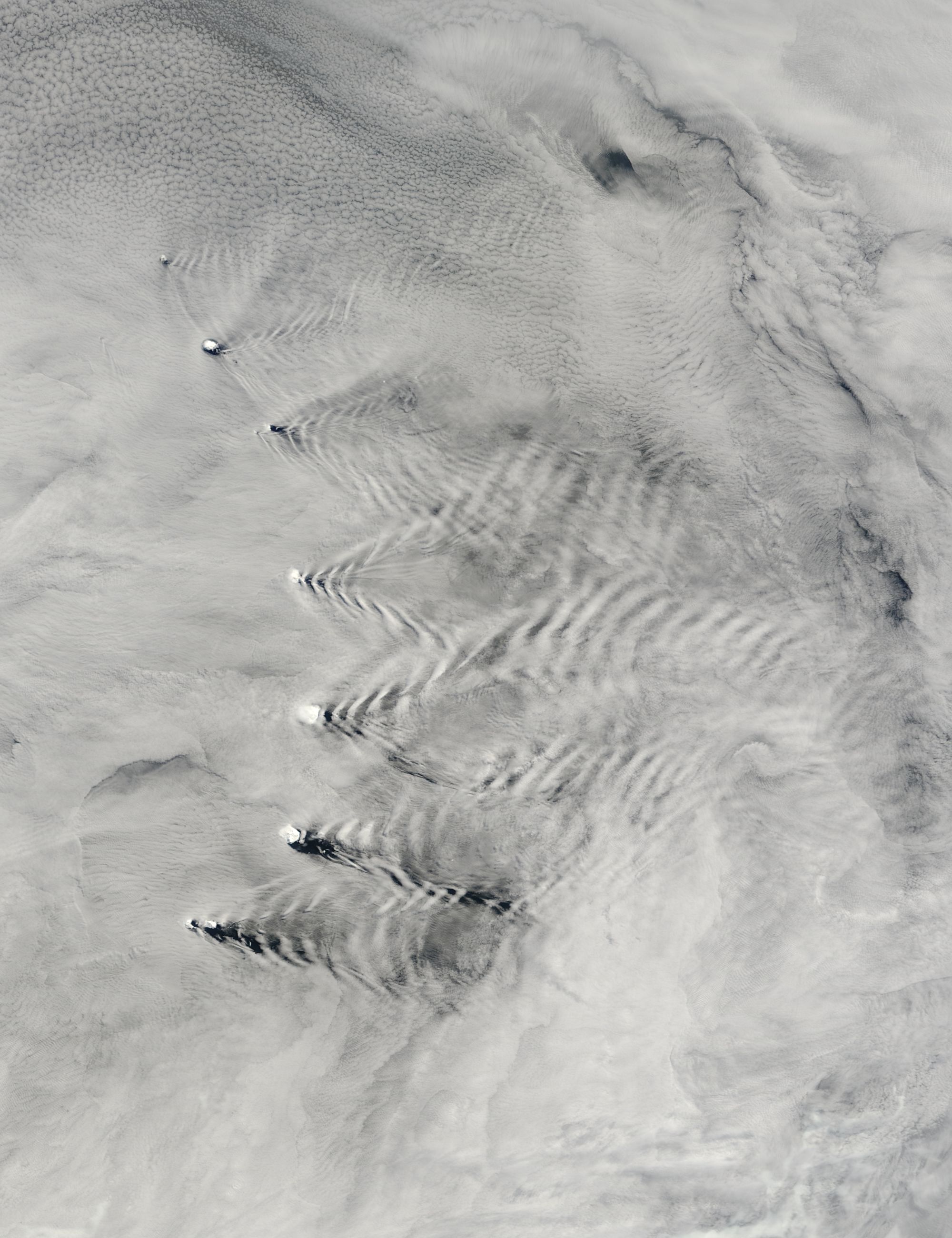
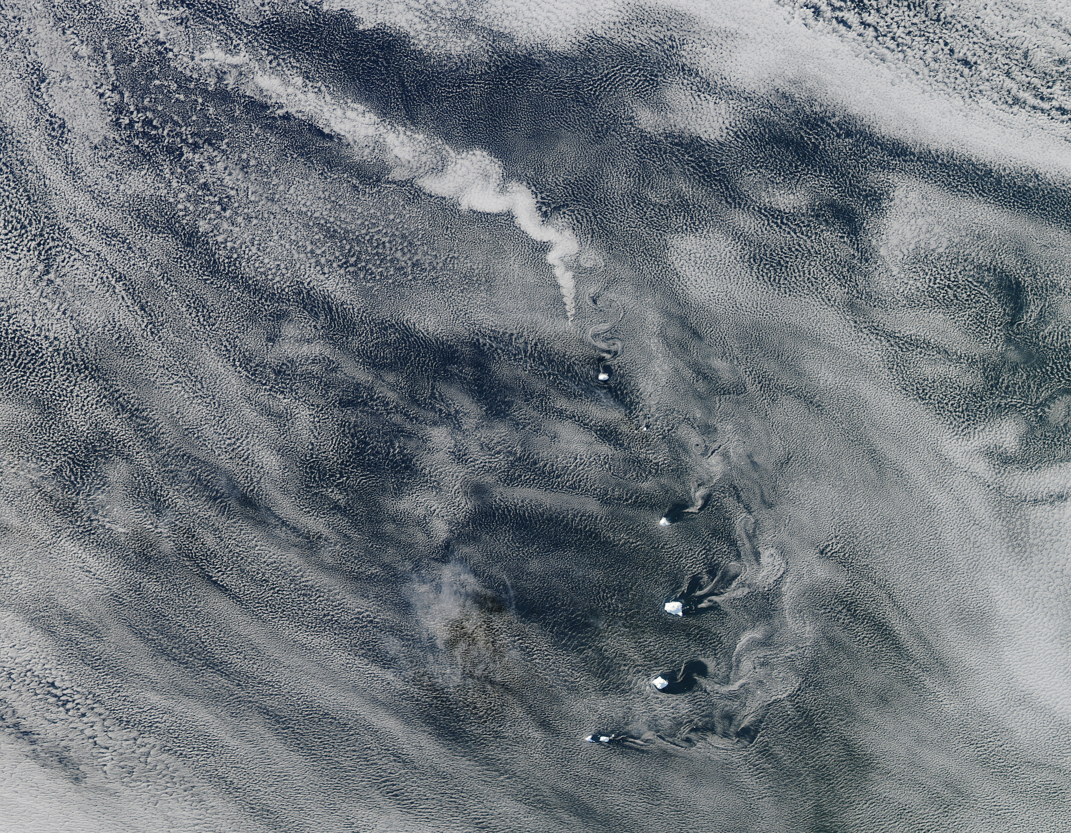
La NASA a déjà mis en ligne à plusieurs reprises ces images surprenantes :

Iles-Sandwich-03

Iles-Sandwich-04

Vous pourrez les voir en haute résolution en cliquant sur ces liens :

Le 23 novembre 2009 : http://eoimages.gsfc.nasa.gov/images/imagerecords/41000/41390/southsand_tmo_2009327_lrg.jpg

Le 27 avril 2012 :

http://eoimages.gsfc.nasa.gov/images/imagerecords/78000/78352/SouthSandwich_amo_2012118_lrg.jpg

 ——————————————-

drapeau anglaisThe South Sandwich Islands are not the best-known place in the world. Located in the South Atlantic Ocean, between South America and Antarctica, this British overseas territory is of volcanic origin and forms an arc of 11 uninhabited islands stretching over 390 kilometres from north to south . It is the result of the subduction of the Scotia plate, on which they are based , beneath the African plate (see map above).

The interior of the islands is particularly inhospitable. It consists of high mountains, sometimes more than 1000 metres above sea level, and is covered with glaciers to 80%.
The South Sandwich Islands often disappear under a cloud layer which makes them very difficult to observe. NASA sometimes uses false colour images to discern what is happening under the clouds. Thus on April 19th, the MODIS spectroradiometer onboard the Aqua satellite allowed to make a surprising image that you will see by clicking on this link:
http://modis.gsfc.nasa.gov/gallery/images/image04302014_1km.jpg

The actual islands appear in bright turquoise, while the clouds are light turquoise and the ocean water deep black. The volcanic plume that can be seen in the northern part of the image is white. It is coming out of a volcano on Zavodovski island before stretching NE. Further south, there is a larger plume from another volcano, Mount Michael, on Saunders Island in the central part of the volcanic arc. The plume is moving NE too, forming a series of vortices. Still farther south, more eddies can be seen behind three other islands. They are known as Von Kármán vortices and are caused by the unsteady separation of flow of a fluid around blunt bodies.

NASA has already posted several times such surprising images :
23 November 2009 : http://eoimages.gsfc.nasa.gov/images/imagerecords/41000/41390/southsand_tmo_2009327_lrg.jpg

27 April 2012 :

http://eoimages.gsfc.nasa.gov/images/imagerecords/78000/78352/SouthSandwich_amo_2012118_lrg.jpg