Islande : bonne vidéo de l’éruption // Iceland : good video of the eruption

L’éruption continue en Islande sur le site de Fagradalsfjall (péninsule de Reykjanes). En cliquant sur le lien ci-dessous, vous verrez une bonne vidéo réalisée à l’aide d’un drone ces derniers jours:

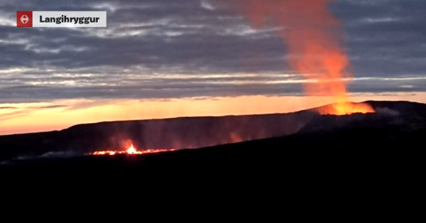
Comme souvent, le document présente des longueurs mais donne une bonne idée de la situation, depuis le cratère actif jusqu’à la vallée de Natthagi où la lave termine sa course. On se rend compte de l’utilité de la digue édifiée il y a quelques semaines et qui canalise la coulée vers l’aval. Voir la carte que j’ai publiée le 17 septembre 2021 pour l’emplacement (barrettes rouges) de ces digues de terre.

https://claudegrandpeyvolcansetglaciers.com/2021/09/17/peninsule-de-reykjanes-islande-carte-de-leruption/

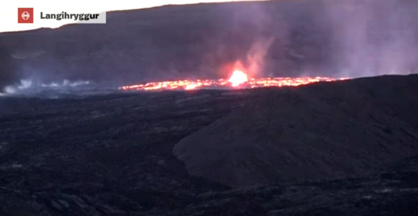
Le débit éruptif ne semble pas très élevé et la lave semble moins fluide que précédemment. En conséquence, elle n’avance pas très loin une fois atteinte la vallée de Natthagi. Pour le moment, aucun signe ne montre qu’elle a envie de se diriger vers l’océan.

————————————-

The eruption continues in Iceland on the site of Fagradalsfjall (Reykjanes peninsula). By clicking on the link below, you will see a good video shot with a drone in recent days:

https://youtu.be/-NscihkfqPk

The document gives a good idea of ​​the situation, from the active crater to the Natthagi Valley where lava ends its course. One realizes the usefulness of the dike built a few weeks ago and which channels the flow downslope. See the map that I published on September 17th, 2021 for the location (red bars) of these earth dikes.

https://claudegrandpeyvolcansetglaciers.com/2021/09/17/peninsule-de-reykjanes-islande-carte-de-leruption/
The eruptive flow does not seem very high and lava looks less fluid than before. As a result, it does not advance very far in the Natthagi Valley. At the moment, there are no signs that it will head for the ocean.

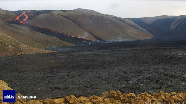
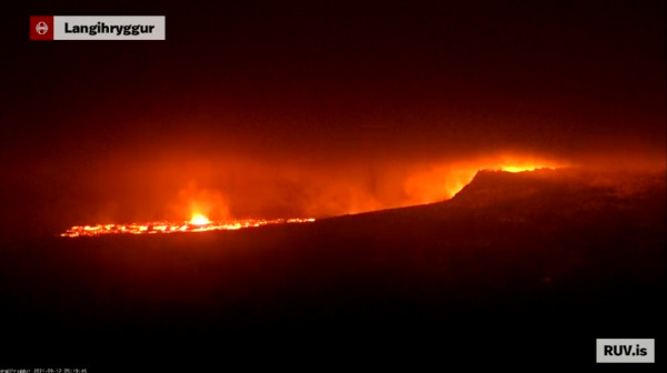
La coulée de lave le 18 septembre 2021 au matin (capture écran webcam)

Eruption islandaise: évacuation en cours // Icelandic eruption: evacuation underway

Selon le site web Iceland Monitor, le site de l’éruption sur la péninsule de Reykjanes est en cours d’évacuation car des coulées de lave traversent le sentier de randonnée A du côté de Fagradalsfjall. Selon le Met Office, il n’y a pas de véritable hausse de l’activité éruptive, mais la lave s’écoule dans la vallée de Geldingadalir le long des digues de protection. Elle recouvre le sentier de A et pénètre dans la vallée de Nátthagi. La zone doit être évacuée car personne ne sait dans quelle direction la lave va se diriger, La lave ne vient pas du cratère proprement dit, mais d’une bouche sur le flanc du cratère. Les photos montrent que la lave se déplace rapidement sous la croûte solidifiée au sud du cratère.

Le Met Office islandais surveille de près l’évolution de la situation tandis que la Protection Civile et la police s’occupent d’évacuer la zone. Entre mille et deux mille personnes se s le secteur au moment de l’évacuation. .

————————————

According to the Iceland Monitor website, the eruption site on the Reykjanes Peninsula had to be evacuated because lava flows are travelling over hiking path A at the eruption site by Fagradalsfjall. According to the Met Office, there is not increased volcanic activity, but lava is flowing into Geldingadalir valleys along the protective walls, over hiking path A and into Nátthagi valley. The area needs to be evacuated, since nobody knows precisely where the lava will flow, The lava does not come from the crater itself, but from a vent on the side of the crater. Photos suggest the lava flows at great speed under the solidified lava, south of the crater.

The Icelandic Met Office monitors developments closely while the Department of Civil Protection and Emergency Management and police are in charge of evacuating the area. Between one and two thousand people were estimated to be in the area at the time of the evacuation.

Fagradalsfjall (Islande): retour de la lave ! // Lava is back !

! 11 septembre – 23 heures: Après plusieurs jours de pause, l’éruption vient de reprendre sur la Péninsule de Reykjanes. Vers 19h15 (heure locale), plusieurs bouches se sont ouvertes au sud du cratère actif. La lave a commencé à s’étaler autour de ces bouches. L’incandescence est ensuite réapparue à l’intérieur du cratère, signe du retour de la lave. Reste à savoir comment va évoluer la situation. Le tremor éruptif semble reprendre de la vigueur lui aussi. Rendez-vous demain matin pour les dernières nouvelles. Voici une vidéo de cet événement:

++++++++++

12 septembre – 7 heures: L’éruption de Fagradalsfjall continue. La lave continue à s’écouler en aval du cratère actif où l’incandescence est toujours présente. Plus que l’ouverture de nouvelles bouches, il semble que la lave emprunte d’anciens tunnels et s’échappe par des lucarnes dans leur voûte. La pression ne semble pas très forte dans les conduits et l’activité éruptive n’est pas très intense. Le tremor amorce un déclin ce matin. Allons nous assister de nouveau à une activité éruptive à répétition? Personne n’a la réponse!

Vue du site éruptif le 12 septembre au matin (capture écran webcam)

————————————————–

11 September – 11:00 pm: After a few days’ pause, the eruption has just resumed on the Reykjanes Peninsula. At around 7:15 p.m. (local time), a new vent opened south of the active crater. Lava began to spread around this vent. Then, incandescence reappeared inside the crater, a sign that lava was back inside. It remains to be seen how the situation will develop. The eruptive tremor seems to gain strength. See you tomorrow morning for the latest news.

See above a video of this event.

++++++++++

12 September – 7 am: The eruption of Fagradalsfjall continues. Lava keeps flowing downslope of the active crater where incandescence is still present. More than the opening of new vents, it seems that lava is travelling along ancient tunnels and squirting through skylights in their vault. The pressure does not appear to be very strong in the ducts and the eruptive activity is not very intense. The tremor is declining this morning. Are we going to witness repeated eruptive activity again? Nobody has the answer!

°°°°°°°°°°

Voici quelques captures d’écran montrant la reprise de l’éruption et le sursaut du tremor :

Captures écran webcam

Source: IMO


Islande: le cratère de Fagradalsfjall // Iceland: the Fagradalsfjall crater

Si vous cliquez sur le lien ci-dessous, vous verrez une vidéo que j’attendais avec impatience car elle montre l’intérieur du cratère édifié par l’éruption de Fagradalsfjall en Islande, sur la péninsule de Reykjanes :

https://www.facebook.com/Vikurfrettir/videos/525573888554701

Comme le montre le tremor volcanique, l’activité éruptive se produit par à-coups réguliers d’intensité similaire, avec des pauses entre les événements. En conséquence, la superficie du champ de lave n’a pas augmenté au cours des dernières semaines et la lave n’a pas envahi de nouvelles terres. Elle a recouvert les vallées de Meradalir, Geldingadalir et Nátthagi, mais s’est arrêtée avant d’atteindre le bord du champ de lave. Tel un mille-feuilles, les couches de lave successives s’entassent près du cratère, encourageant la théorie du volcan bouclier suggérée par les scientifiques islandais il y a quelques semaines.
Il semble évident que le niveau de la lave à l’intérieur du cratère baisse considérablement et très rapidement entre les crises éruptives. À l’aide d’un drone, Jón Steinar Sæmundsson, un habitant de Grindavík, a réalisé la vidéo susmentionnée du cratère lors d’une pause éruptive en juillet.
La vidéo montre que le cratère est très profond jusqu’à l’endroit où se produit la vidange de la lave. Une fois la crise éruptive arrivée à son terme, la coulée de lave s’arrête définitivement, la pression des gaz chute également et le cratère se vide complètement. Lorsque l’éruption reprend, il faut plusieurs heures pour que la lave remplisse le cratère avant de déborder.
À en juger par la vidéo, la cuvette du cratère a une profondeur d’environ 60 à 70 m, mais le puits de vidange est beaucoup plus profond. Lorsque le cratère est inactif, le conduit semble aller très profond, probablement en dessous de la surface du sol d’origine.
Source: Iceland Monitor.

——————————————

If you click on the following link, you will see a video I have impatiently been waiting for because it shows the inside of the crater built by Iceland’s Fagradalsfjall eruption on the Reykjanes Peninsula:

https://www.facebook.com/Vikurfrettir/videos/525573888554701

As shown by the volcanic tremor, eruptive activity occurs in regular pulses of simimar intensity, with pauses between the events. As a consquences, the area of the lava field has not grown in the past weeks, and the lava has not flowed over new land. It reaches Meradalir, Geldingadalir and Nátthagi valleys, but stops before reaching the edge of the lava field. Therefore, it piles up near the crater, encouraging the theory of the shield volcano suggested by Icelandic scientists a few weeks ago.

It ssems the surface of the lava inside the crater drops considerably and very rapidly between the eruptive crises. Using a drone, Jón Steinar Sæmundsson, from Grindavík, shot the above-mentioned video of the crater during an eruptive pause in July.

The video shows that the crater is very deep, down to a drain. Once the eruptive crisis comes to a halt, the lava flow stops completely, the gas pressure drops as well, and the crater empties completely. Once the flow resumes, it takes many hours to fill the crater before lava starts flowing out.

Judging from the video, the crater bowl is about 60-70 m deep, but the drain goes much deeper. While the crater is inactive, it seems the surface of the lava in the conduit drops below the surface of the land prior to the eruption.

Source: Iceland Monitor.

Captures d’écran de la vidéo