Hawaii, le domaine des dieux // Hawaii, the land of gods

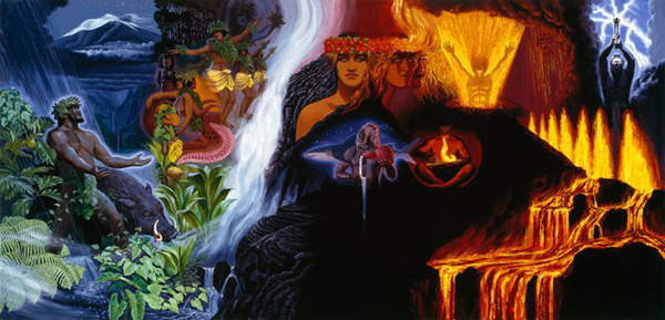
Dans la culture hawaiienne, les forces naturelles sont les manifestations de dieux et de déesses, ou akua. Pele est la déesse des volcans et a un tempérament de feu. Selon les moʻolelo (légendes), Pele vit dans le cratère de l’Halemaʻumaʻu, au sommet du Kīlauea dans le Parc National des Volcans d’Hawaii. Par l’activité volcanique qu’elle provoque, elle représente la renaissance de la Terre car en se refroidissant la lave donne naissance à une terre nouvelle.
Au moment où le Mauna Loa et le Kilauea étaient en éruption, de nombreux Hawaiiens autochtones sont venus chanter (oli), prier ou déposer des hoʻokupu (offrandes) en l’honneur de la déesse. Selon eux, la dernière éruption du Mauna Loa avait une signification culturelle. C’était le signe qu’une plus grande force spirituelle était en jeu, que leurs divinités (akua) étaient bien vivantes et se manifestaient dans un but précis. L’éruption a également été pour les Hawaiiens un moment de réflexion sur leur identité et l’occasion de vivre en harmonie avec la nature.
Pour les Hawaiiens autochtones, le paysage qui compose le Parc National est sacré. Ils se considèrent comme en faisant partie. Ils sont nés de cette Terre; elle est leur mère et le ciel est leur père. La Nature est quelque chose dont ils doivent prendre soin et vivre en harmonie avec elle.
L’éruption du Mauna Loa était spirituelle pour de nombreux Hawaïens dont les familles sont originaires de la Grande Ile. Ils ont vu l’éruption comme une manifestation de la déesse Pele qui est aussi un ancêtre de leur peuple. Pele est venue reprendre la terre (‘aina) qui ne leur a jamais vraiment appartenu. Un natif d’Hawaii a déclaré : « Pele est venue nettoyer la maison. Elle a dit ça suffit. »
La lave du Mauna Loa a coulé en direction du terrain militaire de Pōhakuloa, une zone d’entraînement pour les Marines depuis la Seconde Guerre mondiale. On a accusé les militaires de nuire aux biens archéologiques, aux animaux, y compris ceux en danger d’extinction. Beaucoup de gens se sont réjouis quand ils ont vu que Pele se dirigeait directement vers le terrain militaire de Pōhakuloa, mais la lave n’a causé aucun dégât.
La capacité de création de Pele est contrebalancée par sa capacité de destruction. Les Hawaiiens espèrent que personne ne sera victime de la lave ou que leurs maisons ne seront pas détruites par des coulées, mais en même temps, la lave est source de célébrations. Contrairement à l’éruption du Kīlauea en 2018, qui a détruit des centaines de maisons, l’éruption du Mauna Loa n’a jamais constitué une menace pour les habitations.
Lorsque le Mauna Loa est entré en éruption, la neige recouvrait le sommet du Mauna Kea, une manifestation de Poliʻahu, la déesse de la neige. Selon certains, cela signifiait que les deux déesses se montraient l’une à l’autre.
L’éruption du Mauna Loa a coïncidé avec d’autres événements. Comme je l’ai déjà écrt, l’éruption a débuté à quelques minutes du jour de l’indépendance hawaïenne (Lā Kūʻokoʻa). Célébrée le 28 novembre, Lā Kūʻokoʻa est la date à laquelle Hawaii a été officiellement reconnue comme une nation indépendante par le reste du monde, y compris les États-Unis, en 1843.
L’éruption du Mauna Loa s’est également produite quelques minutes après la mort d’Edith Leina’ala Kanaka’ole Floyd, la fille aînée d’Edith Kanaka’ole, célèbre professeur de hula et défenseur de la culture hawaïenne sur l’île d’Hawaii. La famille et l’association qu’elle avait fondée ont contribué à perpétuer la culture et la tradition hawaiiennes sur la Grande Ile pendant plus de deux décennies, notamment en protégeant les volcans sacrés. Pour les Hawaiiens autochtones, la simultanéité de ces événements n’était pas une coïncidence.
Les Hawaiiens indigènes reprochent aux touristes venus voir l’éruption leur manque de respect et l’engorgement de la Saddle Road. « Quand les gens vont [voir l’éruption], ils doivent y aller avec respect… avec respect pour ce qui se passe, l’éruption, pour Pelé, et aussi pour les gens qui y vivent et qui essaient d’aller travailler. »
Source: USA Today.

——————————————–

In Hawaiian culture, natural forces are manifestations of gods and goddesses, or akua. Pele is the goddess of volcanoes and has a passionate temperament. According to moʻolelo (stories), Pele lives in the Halemaʻumaʻu crater located at the summit of Kīlauea in Hawaii Volcanoes National Park. In the form of volcanic activity, she and her work represent rebirth and resetting, the way lava cools into new, refreshed land.

While Mauna Loa and Kilauea were erupting, many Native Hawaiians visited the lava to chant (oli), pray or leave hoʻokupu (offerings) in honor of the goddess. Many Native Hawaiians found the latest Mauna Loa eruption to be culturally significant. It was a sign of a greater spiritual force at play, that their akua are alive and showing up for a reason. The eruption also provided a moment of reflection on their identity and living in harmony with nature.

To Native Hawaiians, the landscape that makes up the National Park is sacred. They see themselves as part of this Earth. They were born from this land, their land is their mother and the sky is their father, The natural world is something they need to take care of and live in harmony with.

The Mauna Loa eruption was spiritual to many Hawaiians whose families are from Hawaii Island. They saw the eruption as a manifestation of the goddess Pele who is also an ancestor to their people and as her taking back the ‘aina that never really belonged to them,. Said one Native Hawaiian: « It’s about cleaning house. It’s about Pele saying enough is enough. »

The Mauna Loa lava flowed in the direction of the Pōhakuloa Training Area, a training area for the Marines corps since World War II. The area has been accused of harming archaeological assets, animals, including those critically endangered. A lot of people celebrated when they saw that Pele was heading straight toward the center of Pōhakuloa Training Area. However, the lava did not cause any damage.

Pele’s ability to create is balanced by destruction. Native Hawaiians hope that no one is disrupted or their homes succumb to the lava flow, but at the same time, it is something that is celebrated. Unlike Kīlauea’s 2018 eruption, which demolished hundreds of homes, the Mauna Loa eruption never posed a threat to communities.

While Mauna Loa erupted, snow topped the summit of Mauna Kea, a manifestation of Poliʻahu, the snow goddess, which some said meant the two goddesses were showing off to each other.

Mauna Loa’s eruption coincided with other events. As I put it before, the eruption was minutes shy of Hawaiian Independence Day (Lā Kūʻokoʻa). Celebrated on November 28th, Lā Kūʻokoʻa is when Hawaii was formally recognized as an independent nation by the rest of the world, including the U.S., in 1843.

The Mauna Loa eruption was also within minutes of the death of Edith Leinaʻala Kanakaʻole Floyd, the eldest daughter of the late Edith Kanakaʻole, a celebrated hula teacher and advocate of Hawaiian culture on Hawaii Island. The family and their organization have helped to perpetuate Hawaiian culture and tradition on Hawaii Island for over two decades, including protecting the sacred volcanoes. To Native Hawaiians, the timing of these events was not simply coincidence.

Native Hawaiians reproach the tourists who came to see the eruption fortheir lack of respect and for congesting the Saddle Road. « When people go there, they need to go there with respect…with a reverence for what’s happening, the eruption, for Pele, and also respect for the people that live there who are just trying to go to work. »

Source : USA Today.

La déesse Pele dans la Volcano House du Kilauea (Photo: C. Grandpey)

Hunga Tonga-Hunga Ha’apai : l’éruption de tous les records (3ème partie)  // The eruption of all records (part 3)

Le panache volcanique.

Aujourd’hui, les scientifiques qui étudient l’éruption du 15 janvier 2022 sont surpris par sa puissance et les records s’accumulent. Par exemple, le panache volcanique a atteint des hauteurs encore jamais observées par les satellites.

Source: Tonga Services

Deux satellites météorologiques – le Geostationary Operational Environmental Satellite 17 (GOES-17) de la NOAA et le Himawari-8 de l’Agence japonaise d’exploration aérospatiale – ont observé cette éruption exceptionnelle depuis l’espace, ce qui a permis aux scientifiques de calculer jusqu’où le panache avait pénétré dans l’atmosphère. Ils ont déterminé que, à son point culminant, le panache s’est élevé à une hauteur de 58 km, ce qui signifie qu’il a percé la mésosphère, la troisième couche de l’atmosphère. Le panache du Hunga Tonga était toutefois loin d’atteindre la couche atmosphérique suivante, la thermosphère, qui commence à environ 85 km au-dessus de la surface de la Terre. La ligne Karman, à une centaine de kilomètres au-dessus de la surface de la Terre, est généralement considérée comme la frontière avec l’espace. Après qu’une première explosion ait généré ce panache très volumineux, une nouvelle explosion a propulsé des cendres, du gaz et de la vapeur à plus de 50 km dans le ciel.
Jusqu’à présent, les panaches volcaniques les plus élevés ont été émis par l’éruption de 1991 du Pinatubo aux Philippines avec 40 km, et l’éruption de 1982 d’El Chichón au Mexique avec 31 km. Les éruptions volcaniques du passé ont probablement produit des panaches plus importants, mais elles se sont produites avant que les scientifiques puissent effectuer de telles mesures. Le panache de l’éruption du Krakatau en 1883 en Indonésie a probablement, lui aussi, atteint la mésosphère.
Les scientifiques n’ont pas pu utiliser leur technique habituelle basée sur la température pour mesurer le panache volcanique car l’éruption de janvier a dépassé la hauteur maximale pour laquelle cette méthode peut être utilisée. Ils se sont tournés vers trois satellites météorologiques géostationnaires qui fournissent des images toutes les 10 minutes et ils se sont appuyés sur l’effet de parallaxe.

Images montrant l’étendue du nuage de cendres au moment de l’éruption du Hunga-Tonga Hunga-Ha’apai (Source: USGS)

Perturbation spatiale.

L’éruption du Hunga Tonga Hunga Ha’apai a généré l’une des plus grandes perturbations spatiales jamais observées au cours de l’ère moderne. Elle permet aux scientifiques d’analyser le lien encore mal compris entre la basse atmosphère et l’espace. L’événement permet également d’étudier comment les événements sur Terre peuvent affecter la météo dans l’espace, à côté de l’influence de la météo spatiale sur la météo terrestre.
Lorsque le volcan est entré en éruption, l’explosion a créé d’importantes perturbations de pression dans l’atmosphère, ce qui a provoqué des vents violents. Au fur et à mesure que ces vents se sont dirigés vers les couches atmosphériques plus minces, ils ont commencé à s’accélérer. Lorsqu’ils ont atteint l’ionosphère et les confins de l’espace, on a enregistré des vitesses de vent allant jusqu’à 725 km/h, ce qui en fait les vents les plus violents – en dessous de 195 km d’altitude – jamais mesurés par la mission ICON depuis son lancement en 2019.
Dans l’ionosphère, ces vents très puissants ont également affecté les courants électriques. Les particules ionosphériques génèrent régulièrement un courant électrique qui se dirige vers l’est – l’électrojet équatorial – alimenté par les vents de la basse atmosphère. Après l’éruption, l’électrojet équatorial a atteint cinq fois sa puissance de crête normale et a radicalement changé de direction; il s’est dirigé vers l’ouest pendant une courte période. C’est quelque chose qui n’avait été observé auparavant que pendant de fortes tempêtes géomagnétiques.
On estime maintenant que l’indice d’explosivité volcanique (VEI) de l’éruption du Hunga Tonga a atteint 6 sur une échelle de 8 niveaux, ce qui la place parmi les plus grandes éruptions volcaniques jamais enregistrées avec des instruments géophysiques modernes.

La vapeur d’eau.

Au cours de l’éruption du 15 janvier 2022, le volcan a également émis une quantité colossale de vapeur d’eau dans l’atmosphère. Selon la NASA, il a envoyé dans la stratosphère suffisamment de vapeur d’eau pour remplir 58 000 piscines olympiques. Les scientifiques expliquent que l’événement a battu « tous les records » d’injection de vapeur d’eau depuis que les satellites ont commencé à enregistrer ce type de données.
Le Microwave Limb Sounder à bord du satellite Aura de la NASA, qui mesure les gaz dans l’atmosphère, a découvert que l’explosion avait envoyé quelque 146 téragrammes d’eau dans la stratosphère, entre environ 13 et 53 kilomètres au-dessus de la surface de la planète. Un téragramme (Tg) équivaut à 10 12 grammes ou 10 9 kilogrammes. Cette énorme quantité de vapeur a augmenté la quantité totale d’eau dans la stratosphère d’environ 10 %. C’est près de quatre fois la quantité de vapeur d’eau entrée dans la stratosphère au moment de l’éruption du Pinatubo en 1991 aux Philippines.
Depuis que la NASA a commencé à effectuer des mesures il y a 18 ans, seules deux autres éruptions, celle du Kasatochi en Alaska en 2008 et du Calbuco en 2015 au Chili, ont envoyé des quantités importantes de vapeur d’eau à des altitudes aussi élevées. Dans les deux cas, les nuages de vapeur d’eau se sont rapidement dissipés.
On pense que la caldeira du volcan sous-marin, une dépression d’environ 150 mètres de profondeur, est à l’origine de l’émission exceptionnelle de vapeur d’eau. Si la caldeira avait été moins profonde, l’eau de mer n’aurait pas été assez chaude pour expliquer une telle quantité de vapeur d’eau; si elle avait été plus profonde, la trop grande pression exercée par l’eau de mer aurait atténué le souffle de l’explosion.

Source: NASA

——————————————–

The volcanic plume.
Today, scientists studying the January 15th, 2022 eruption are amazed at its power and records are piling up. For example, the volcanic plume reached heights never before seen by satellites.
Two weather satellites – NOAA’s Geostationary Operational Environmental Satellite 17 (GOES-17) and the Japan Aerospace Exploration Agency’s Himawari-8 – observed this exceptional eruption from space, allowing scientists to calculate how high the plume had penetrated the atmosphere. They determined that, at its peak, the plume rose to a height of 58 km, meaning it pierced the mesosphere, the third layer of the atmosphere. The Hunga Tonga plume, however, was far from reaching the next atmospheric layer, the thermosphere, which begins about 85 km above the Earth’s surface. The Karman line, a hundred kilometers above the surface of the Earth, is generally considered the boundary with space. After a first explosion generated this very large plume, a new explosion propelled ash, gas and steam more than 50 km into the sky.
The highest volcanic plumes had been emitted by the 1991 eruption of Pinatubo in the Philippines with 40 km, and the 1982 eruption of El Chichón in Mexico with 31 km. Volcanic eruptions in the past likely produced larger plumes, but they happened before scientists could make such measurements. The plume from the 1883 eruption of Krakatau in Indonesia probably also reached the mesosphere.
Scientists were unable to use their usual temperature-based technique to measure the volcanic plume because the January eruption exceeded the maximum height for which this method can be used. They turned to three geostationary weather satellites that provide images every 10 minutes and they relied on the parallax effect.

Space disturbances.
The eruption of Hunga Tonga Hunga Ha’apai generated one of the largest space disturbances ever observed in the modern era. It allows scientists to analyze the still poorly understood link between the lower atmosphere and space. The event also helps to study how events on Earth can affect weather in space, alongside the influence of space weather on terrestrial weather.
When the volcano erupted, the explosion created significant pressure disturbances in the atmosphere, which caused strong winds. As these winds moved towards the thinner atmospheric layers, they began to pick up speed. When they reached the ionosphere and the outer reaches of space, wind speeds of up to 725 km/h were recorded, making them the strongest winds – below 195 km altitude – ever measured by the ICON mission since its launch in 2019.
In the ionosphere, these very powerful winds also affected electric currents. Ionospheric particles regularly generate an electric current that heads east – the equatorial electrojet – powered by winds from the lower atmosphere. After the eruption, the equatorial electrojet reached five times its normal peak power and drastically changed direction; it headed west for a short time. This is something that had previously only been observed during strong geomagnetic storms.
The Volcanic Explosivity Index (VEI) for the Hunga Tonga eruption is now estimated to have reached 6 on an 8-level scale, placing it among the largest volcanic eruptions ever recorded with modern geophysical instruments.

Water vapor.
During the January 15, 2022 eruption, the volcano also emitted a colossal amount of water vapor into the atmosphere. According to NASA, it sent enough water vapor into the stratosphere to fill 58,000 Olympic swimming pools. The scientists say the event broke « every record » for water vapor injection since satellites began recording such data.
The Microwave Limb Sounder aboard NASA’s Aura satellite, which measures gases in the atmosphere, found the explosion sent some 146 teragrams of water into the stratosphere, between about 13 and 53 kilometers above the surface of the planet. One teragram (Tg) is equal to 1012 grams or 109 kilograms. This huge amount of steam increased the total amount of water in the stratosphere by about 10%. That’s nearly four times the amount of water vapor that entered the stratosphere when Mt Pinatubo erupted in the Philippines in 1991.
Since NASA began making measurements 18 years ago, only two other eruptions, Kasatochi in Alaska in 2008 and Calbuco in 2015 in Chile, have sent significant amounts of water vapor to similar altitudes. In both cases, the water vapor clouds quickly dissipated.
It is believed that the caldera of the submarine volcano, a depression about 150 meters deep, was the source of the exceptional emission of water vapor. If the caldera had been shallower, the seawater would not have been warm enough to account for such an amount of water vapour; if it had been deeper, the excessive pressure exerted by the sea water would have reduced the blast of the explosion.

Hunga Tonga-Hunga Ha’apai : l’éruption de tous les records (2ème partie)  // The eruption of all records (part 2)

L’éruption du 15 janviers 2022.

Une puissante éruption a de nouveau eu lieu sur le volcan Hunga Tonga-Hunga Ha’apai le 15 janvier 2022. Le panache de cendre et de gaz s’est élevé à environ 16,7 km au-dessus du niveau de la mer, selon le VAAC de Wellington. Il s’est étendu de manière concentrique sur une distance d’environ 130 km par rapport au volcan, créant un panache de 260 km de diamètre. Selon le service géologique des Tonga, l’éruption a duré plus de 12 heures. C’est la plus importante observée depuis décembre 2021.

Source: Tonga Services

Tsunami.

Des vagues de tsunami de 83 cm ont été observées par des jauges à Nuku’alofa et des vagues de 60 cm ont été enregistrées à Pago Pago, la capitale des Samoa américaines. Une alerte tsunami a été émise pour toutes les îles des Tonga; il a été conseillé aux habitants de s’éloigner de la côte. Le tsunami a détruit des villages et coupé les communications dans l’archipel des Tonga et ses 105 000 habitants. Trois personnes ont été tuées. Ce bilan est faible car la population est bien préparée pour faire face à un tsunami. Les habitants sont même probablement parmi les mieux préparés pour affronter les catastrophes naturelles, avec des années d’exercices tsunami: C’est pourquoi de nombreuses personnes ont su se réfugier sur des endroits plus élevés.

La vague de tsunami a provoqué une marée noire au Pérou lorsqu’un pétrolier battant pavillon italien a déversé 6 000 barils de pétrole dans l’océan Pacifique, près de la raffinerie de La Pampilla dans la banlieue de Lima. Le pétrolier déchargeait sa cargaison à La Pampilla lorsque la connexion entre le navire et le terminal s’est rompue.

Une particularité de la vague de tsunami est sa hauteur. D’après une étude récente publiée dans la revue Ocean Engineering, elle aurait atteint une hauteur de 90 mètres à son point de départ, soit environ neuf fois la hauteur du tsunami qui a frappé les côtes du Japon le 11 mars 2011, avec à la clé la catastrophe à la centrale nucléaire de Fukushima. Un autre puissant tsunami a également frappé le Chili en 1960. Que ce soit au Japon ou au Chili, la hauteur initiale de la vague a été estimée à une dizaine de mètres, autrement dit rien en comparaison de celle générée lors de l’éruption du Hunga Tonga-Hunga Ha’apai.

Les tsunamis de 2011 et 1960 ont pourtant été bien plus dévastateurs et meurtriers. Plus de 18.000 personnes ont péri en 2011, alors que le tsunami du Hunga Tonga n’a causé la disparition que de quelques personnes. Les scientifiques prennent en compte plusieurs paramètres pour expliquer cette différence de bilan. Il y a la distance entre la source du tsunami et les terres, la morphologie du plancher océanique et du littoral, mais également d’autres facteurs, comme la fusion de plusieurs vagues, comme cela semble s’être produit en 2011. À l’approche des côtes, une vague de tsunami peut ainsi être soit être atténuée, ou bien amplifiée. Le volcan Hunga Tonga est situé à environ 70 kilomètres des îles Tonga. C’est probablement cette distance qui a permis d’éviter le pire.

Source : USGS

Onde de choc.

L’onde de choc générée par l’éruption a parcouru plusieurs milliers de kilomètres, a été observée depuis l’espace et enregistrée en Nouvelle-Zélande à environ 2000 km. Elle s’est déplacée à plus de 300 mètres par seconde et était si puissante qu’elle a fait résonner l’atmosphère comme le fait une cloche. C’est l’onde de choc la plus puissante depuis l’éruption du Krakatau (Indonésie) en 1883. Grâce au transfert de cette énergie de l’atmosphère vers l’océan, l’onde de choc a amplifié les vagues océaniques dans le monde entier, les a repoussées plus loin et a accéléré leur vitesse de déplacement, un phénomène pour lequel les centres d’alerte aux tsunamis se sont pas équipés. Les modèles de prévision et les systèmes d’alerte, conçus principalement pour évaluer les vagues déclenchées par les séismes conventionnels, ont été déconcertés par l’événement des Tonga et ont donc commis des erreurs.

Effets de l’éruption Source : NASA

Perturbations atmosphériques.

Plusieurs études ont indiqué que l’éruption du volcan Hunga Tonga-Hunga Ha’apai a provoqué des perturbations à grande échelle dans l’atmosphère terrestre. En utilisant les données enregistrées par plus de 5 000 récepteurs GNSS – Global Navigation Satellite System – situés à travers le monde, les scientifiques de l’Observatoire Haystack du Massachusetts Institute of Technology (MIT) et leurs collègues de l’Université arctique de Norvège ont observé des preuves d’ondes atmosphériques générées par les éruptions et de leurs empreintes ionosphériques à 300 kilomètres au-dessus de la surface de la Terre, et cela pendant une longue période. Ces ondes atmosphériques ont été actives pendant au moins quatre jours après l’éruption et ont fait trois fois le tour du globe. Les perturbations ionosphériques sont passées au-dessus des États-Unis six fois, d’abord d’ouest en est, puis en sens inverse. Cette éruption a été extraordinairement puissante et a libéré une énergie équivalente à 1 000 bombes atomiques de Hiroshima.
Une autre étude, menée par des chercheurs du MIT Haystack Observatory et de l’Arctic University of Norway, a été publiée le 23 mars 2022 dans la revue Frontiers in Astronomy and Space Sciences. Les auteurs pensent que les perturbations atmosphériques sont un effet des ondes de Lamb ; ces ondes, ainsi appelées d’après le mathématicien Horace Lamb, se déplacent à la vitesse du son sans grande réduction de leur amplitude. Bien qu’elles soient principalement situées près de la surface de la Terre, ces ondes peuvent échanger de l’énergie avec l’ionosphère de manière complexe. La nouvelle étude précise que « la présence dominante des ondes de Lamb a déjà été signalée lors de l’éruption du Krakatau en 1883 et à d’autres occasions. L’étude fournit pour la première fois une preuve substantielle de leurs empreintes de longue durée dans l’ionosphère à l’échelle de la planète. »

—————————————

The eruption of January 15, 2022.
A powerful eruption took place again on the Hunga Tonga-Hunga Ha’apai volcano on January 15th, 2022. The plume of ash and gas rose about 16.7 km above sea level, according to the Wellington VAAC. It extended concentrically over a distance of about 130 km from the volcano, creating a plume 260 km in diameter. According to the Tonga Geological Survey, the eruption lasted more than 12 hours. This was the largest eruption since December 2021.

A tsunami.
Tsunami waves of 83 cm were observed by gauges in Nuku’alofa and waves of 60 cm were recorded in Pago Pago, the capital of American Samoa. A tsunami warning was issued for all islands in Tonga; locals were advised to move away from the coast. The tsunami destroyed villages and cut communications in the Tonga archipelago and its 105,000 inhabitants. Three people were killed. This death toll is low because the population is well prepared to face a tsunami. The inhabitants are even probably among the best prepared to face natural disasters, with years of tsunami exercises: This is why many people knew how to take refuge on higher places.
The tsunami wave caused an oil spill in Peru when an Italian-flagged tanker spilled 6,000 barrels of oil into the Pacific Ocean near the La Pampilla refinery on the outskirts of Lima. The tanker was unloading its cargo at La Pampilla when the connection between the ship and the terminal broke.
A peculiarity of the tsunami wave was its height. According to a recent study published in the journal Ocean Engineering, it probably reached a height of 90 meters at its starting point, approximately nine times the height of the tsunami which hit the coasts of Japan on March 11th, 2011, with the disaster at the Fukushima nuclear plant. Another powerful tsunami also hit Chile in 1960. Whether in Japan or Chile, the initial height of the wave was estimated at ten meters, in other words nothing compared to that generated during the eruption of the Hunga Tonga-Hunga Ha’apai.
The 2011 and 1960 tsunamis, however, were far more devastating and deadly. More than 18,000 people died in 2011, while the Hunga Tonga tsunami caused the deaths of only a few people. Scientists take into account several parameters to explain this difference. There is the distance between the source of the tsunami and the land, the morphology of the ocean floor and the coastline, but also other factors, such as the merger of several waves, as seems to have happened in 2011. Approaching the coast, a tsunami wave can thus either be attenuated or amplified. The Hunga Tonga volcano is located about 70 kilometers from the Tonga Islands. It is probably this distance that made it possible to avoid the worst.

A shock wave.
The shock wave generated by the eruption traveled several thousand kilometres, was observed from space and recorded in New Zealand around 2000 km away. It moved at over 300 meters per second and was so powerful that it rang the atmosphere like a bell. It was the most powerful shock wave since the eruption of Krakatau (Indonesia) in 1883. Thanks to the transfer of this energy from the atmosphere to the ocean, the shock wave amplified the ocean waves in the world, pushed them further and accelerated their speed, a phenomenon for which the tsunami warning centers are not equipped. Prediction models and warning systems, designed primarily to assess waves triggered by conventional earthquakes, were confused by the Tonga event and therefore made mistakes.

Atmospheric disturbances.
Several studies have indicated that the eruption of the Hunga Tonga-Hunga Ha’apai volcano caused large-scale disturbances in the Earth’s atmosphere. Using data recorded by more than 5,000 GNSS – Global Navigation Satellite System – receivers located around the world, scientists from the Haystack Observatory at the Massachusetts Institute of Technology (MIT) and their colleagues from the Arctic University of Norway have observed evidence of atmospheric waves generated by eruptions and their ionospheric footprints 300 kilometers above the Earth’s surface, and this for a long time. These atmospheric waves were active for at least four days after the eruption and circled the globe three times. Ionospheric disturbances passed over the United States six times, first from west to east, then in the opposite direction. This eruption was extraordinarily powerful and released energy equivalent to 1,000 Hiroshima atomic bombs.
Another study, conducted by researchers at MIT Haystack Observatory and the Arctic University of Norway, was published on March 23rd, 2022 in the journal Frontiers in Astronomy and Space Sciences. The authors believe that atmospheric disturbances are an effect of Lamb waves; these waves, so called after the mathematician Horace Lamb, travel at the speed of sound without much reduction in their amplitude. Although mostly located near the Earth’s surface, these waves can exchange energy with the ionosphere in complex ways. The new study states that « the dominant presence of Lamb waves was already reported during the eruption of Krakatau in 1883 and on other occasions. The study provides for the first time substantial evidence of their long-lasting footprints in the ionosphere on a planetary scale. »

Hunga Tonga-Hunga Ha’apai : l’éruption de tous les records (1ère partie)  // The eruption of all records (part 1)

Pour comprendre ce qui s’est passé le 15 janvier 2022, il est intéressant d’observer la situation au cours des semaines précédentes.

Fin décembre 2014, un volcan sous-marin est entré en éruption dans le Pacifique sud, dans le Royaume des Tonga, avec des panaches de vapeur et de cendre, ainsi que des projections de matériaux. Les panaches de cendre sont montés jusqu’à 9 kilomètres dans le ciel, occasionnant des perturbations au trafic aérien. Quand la cendre a finalement cessé de retomber en janvier 2015, la nouvelle île – qui culminait à 120 mètres de hauteur – était bien installée entre deux îles plus anciennes, et les trois édifices purent être observés par les satellites.

Crédit photo : Woods Hole Oceanographic Institution

On pensait généralement que la nouvelle île, baptisée Hunga Tonga-Hunga Ha’apai, ne subsisterait que quelques mois, tandis qu’une étude de la NASA lui prévoyait une durée de vie de 6 à 30 ans.
Hunga Tonga-Hunga Ha’apai était la première île de ce type à sortir de l’océan et à persister depuis le début des observations satellitaires. C’était la troisième île volcanique « surtseyenne » à avoir émergé et persisté pendant plus de quelques mois au cours des 150 dernières années. (Surtsey a commencé à se former au cours d’une éruption explosive similaire au large des côtes islandaises en 1963.)


Vue de Hunga Tonga-Hunga Ha’apai en juin 2017 (Crédit photo: NASA)

Au cours des six premiers mois qui ont suivi l’éruption de décembre 2014, la nouvelle île était de forme relativement ovale et rattachée à l’île voisine à l’ouest. Cependant, en avril 2015, l’analyse des images satellitaires a révélé que sa forme avait radicalement changé. En mai, le rebord sud-est de la paroi interne du cratère a été emporté par les vagues du Pacifique, exposant le lac de cratère aux assauts de l’océan. À ce stade, les scientifiques de la NASA ont pensé que ce pourrait être la mort de l’île. Ce ne fut pas le cas car en juin l’imagerie satellitaire a montré qu’une barre de sable s’était formée et fermait le cratère. L’île continua à évoluer et devint plus stable à la fin de l’année 2016. Lorsque les scientifiques ont cartographié le plancher océanique en 2016, ils ont découvert une caldeira qui se cachait à 150 mètres de profondeur sous la surface de la mer. La caldeira mesurait environ 5 km de diamètre.

Source : The Conversation

Une nouvelle éruption a débuté le 19 décembre 2021 à Hunga Tonga-Hunga Ha’apai, avec un panache de vapeur s’élevant jusqu’à 6 km d’altitude. L’éruption a baissé d’intensité au cours des premiers jours de janvier 2022. Plusieurs épisodes surtseyens pouvant durer jusqu’à 30 minutes se sont produits au cours des derniers jours de décembre 2021 avec des panaches de gaz, de vapeur et de cendres s’élevant parfois à 12 km d’altitude. Une décoloration de l’eau ainsi que des bancs de pierre ponce étaient visibles autour de l’île le 30 décembre et avaient déjà été observés depuis le début de l’éruption.

La naissance de l’île avait été très spectaculaire, avec de superbes cypressoïdes typiques des éruptions phréato-magmatiques. (Crédit photo : USGS)

—————————————-

To understand what happened on January 15th, 2022, it is interesting to observe the situation during the prededing weeks.

At the end of December 2014, an underwater volcano erupted in the South Pacific, in the Kingdom of Tonga, with steam and ash plumes, as well as projections of material. Ash plumes rose up to 9 kilometers into the sky, causing disruption to air traffic. When the ash finally stopped falling in January 2015, the new island – which peaked at 120 meters in height – was well established between two older islands, and the three edifices could be observed by satellites.

The new island, dubbed Hunga Tonga-Hunga Ha’apai, was widely thought to last only a few months, while a NASA study predicted a lifespan of 6 to 30 years.
Hunga Tonga-Hunga Ha’apai was the first such island to emerge from the ocean and persist since satellite observations began. It was the third « Surtseyan » volcanic island to have emerged and persisted for more than a few months in the past 150 years. (Surtsey began to form during a similar explosive eruption off the coast of Iceland in 1963.)

During the first six months after the December 2014 eruption, the new island was relatively oval in shape and attached to the neighboring island to the west. However, in April 2015, analysis of satellite images revealed that its shape had changed dramatically. In May, the southeast rim of the inner crater wall was washed away by Pacific waves, exposing the crater lake to the assault of the ocean. At this point, NASA scientists thought it might be the death of the island. This was not the case because in June satellite imagery showed that a sandbar had formed and was closing the crater. The island continued to evolve and became more stable at the end of 2016. When scientists mapped the ocean floor in 2016, they discovered a caldera that lurked 150 meters deep below the sea surface. The caldera was about 5 km in diameter.

An eruption began on December 19th, 2021 at Hunga Tonga-Hunga Ha’apai, with a steam plume rising up to 6 km a.s.l. The eruption decreased in intensity during the first days of January 2022. Several Surtseyan episodes lasting up to 30 minutes occurred during the last days of December 2021 with plumes of gas, steam and ash sometimes rising to 12 km altitude. Discoloration of the water as well as pumice rafts were visible around the island on December 30th and had already been observed since the start of the eruption.