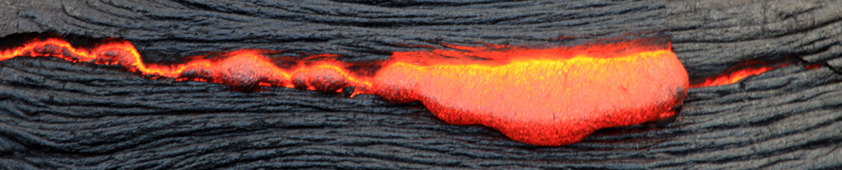
![]() Comme je l’ai écrit à plusieurs reprises, le site éruptif de l’Holuhraun a été fermé au public en raison d’émissions de SO2 trop dangereuses. Pour le moment, les scientifiques et les représentants des médias sont les seules personnes autorisées sur le site, à condition de porter des masques à gaz.
Comme je l’ai écrit à plusieurs reprises, le site éruptif de l’Holuhraun a été fermé au public en raison d’émissions de SO2 trop dangereuses. Pour le moment, les scientifiques et les représentants des médias sont les seules personnes autorisées sur le site, à condition de porter des masques à gaz.
De plus en plus de touristes aimeraient pouvoir admirer l’éruption dans l’Holuhraun et de nombreux étrangers ont contacté les agences de tourisme islandaises dans ce sens.
Une réunion a été organisée avec la Protection Civile et les autorités islandaises afin d’étudier la possibilité de fournir aux touristes un meilleur accès à l’éruption. Le résultat est que les conditions de sécurité ne sont pas suffisantes en ce moment pour rouvrir la zone interdite d’accès au nord du Vatnajökull. Toutefois, la Protection Civile va essayer de déterminer quelles routes peuvent devenir accessibles et une réunion de suivi aura lieu plus tard dans la semaine.
Les survols en avion et en hélicoptère ont été autorisés.
Une carte de la fermeture des routes est accessible sur le site de l’Icelandic Road and Coastal Administration:
http://www.vegagerdin.is/english
Il suffit de cliquer sur une zone pour voir quelles routes sont ouvertes à la circulation.
Source: Iceland Review.
————————————-
![]() As I put it before, the eruptive site in Holuhraun has been closed to the public because of dangerous SO2 emissions. For the time being, scientists and representatives of the media are the only persons allowed on the site, provided they do wear gas masks.
As I put it before, the eruptive site in Holuhraun has been closed to the public because of dangerous SO2 emissions. For the time being, scientists and representatives of the media are the only persons allowed on the site, provided they do wear gas masks.
More and more tourists are interested in seeing the eruption and Icelandic tourism companies are being approached by prospective tourists from abroad, who are interested in viewing the eruption in Holuhraun up close.
A meeting has been organised with the Civil Protection Department and Icelandic authorities to discuss the possibility of providing tourists with better access to the eruption. The result is that it is not yet safe to reopen the closed-off area north of Vatnajökull. However, the Department is looking into which routes can me made accessible and a follow-up meeting will be held later this week.
Sightseeing tours by plane and helicopter have been authorized.
A map of road closures can be found on the website of the Icelandic Road and Coastal Administration:
http://www.vegagerdin.is/english
Just click on an area to see which roads are open to the traffic.
Source: Iceland Review.
