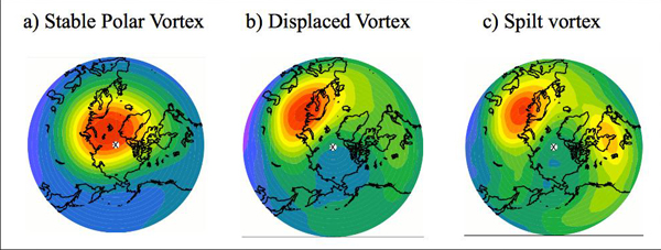
Nouveau réchauffement stratosphérique soudain // New sudden stratospheric warming

Un réchauffement stratosphérique soudain (en anglais Sudden Stratospheric Warming ou SSW) est un phénomène météorologique pendant lequel le vortex polaire dans l’hémisphère hivernal voit ses vents généralement d’ouest ralentir ou même s’inverser en quelques jours. Un tel phénomène va rendre le vortex plus sinueux, voire le rompre. Le changement est dû à une élévation de la température stratosphérique de plusieurs dizaines de degrés au-dessus du vortex. Elle grimpe très rapidement, passant de -70/-80°C à -10/-20°C degrés (soit une élévation d’une soixantaine de degrés en quelques jours).  Pour rappel, la stratosphère est la couche atmosphérique située au dessus de celle où nous vivons – la troposphère – à une altitude située entre 10 et 50 km environ.

Durant un hiver habituel dans l’hémisphère nord, plusieurs événements mineurs de réchauffement stratosphérique se produisent, avec un événement majeur environ tous les deux ans. Dans l’hémisphère sud, les SSW semblent moins fréquents et moins bien compris.

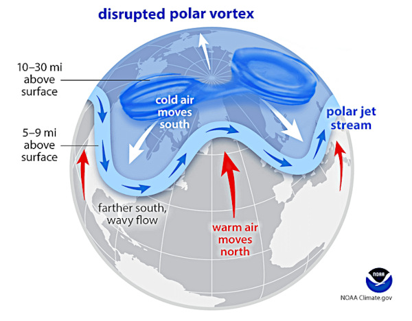
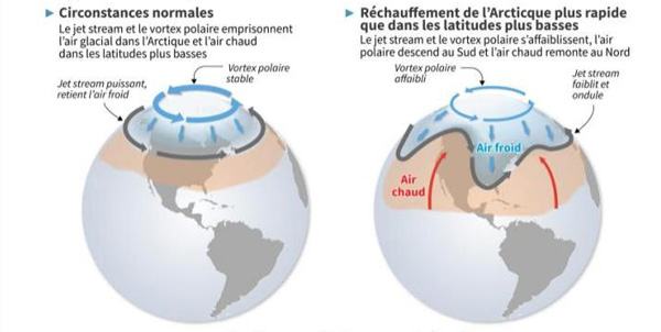
En conséquence, un réchauffement stratosphérique soudain et ses implications pour le vortex polaire peuvent avoir de sérieuses conséquences sur le climat de nos latitudes. L’air froid peut se retrouver piégé dans le jet stream (frontière entre l’air froid polaire et de l’air doux des tropiques) et être décalé jusqu’à nos latitudes, dans des régions peu habituées à un froid glacial, comme ce fut le cas en mars 2018 en Europe ou en février 2012 en France. Ces épisodes de SSW ne semblent toutefois pas avoir de relation avec le réchauffement climatique actuel ; ce sont de simples événements climatiques ponctuels.

°°°°°°°°°°

Les températures à haute altitude au-dessus du pôle Nord montent actuellement en flèche ; elles ont atteint 10°C en à peine une semaine. Ce réchauffement stratosphérique soudain perturbe le vortex polaire, ce qui pourrait avoir des conséquences importantes pour les conditions météorologiques dans l’hémisphère nord au mois de mars.
Cependant, le phénomène est encore mal compris et les scientifiques, bien qu’ils aient réussi à prévoir cet événement de réchauffement il y a deux semaines, disent qu’il est trop tôt pour savoir quel impact cela aura sur la météo dans les latitudes inférieures. Ces événements de réchauffement, qui se produisent en moyenne deux hivers sur trois, ne se déroulent pas toujours de la même manière.
Il se dit que l’événement actuel pourrait déclencher une réaction en chaîne qui chamboulerait les modèles météorologiques. Par exemple, l’est des États-Unis a connu des mois de janvier et de février exceptionnellement doux. Certains précédents réchauffements stratosphériques soudains accompagnés de perturbations du vortex polaire ont provoqué des vagues de froid extrêmes et de violentes tempêtes hivernales.
La dernière fois qu’un réchauffement stratosphérique soudain s’est produit, c’était le 5 janvier 2021. Un peu plus d’un mois plus tard, une vague d’air froid jamais vue depuis 1989 a plongé le centre des États-Unis dans une période de gel historique, provoquant la mise à l’arrêt du réseau électrique au Texas, un bilan de 330 morts, et plus de 27 milliards de dollars de dégâts.
Les scientifiques interrogés sur l’événement en cours disent qu’il est trop tôt pour savoir s’il déclenchera des conditions météorologiques extrêmes ou modifiera de manière significative les régimes météorologiques en cours dans l’hémisphère nord.

Les premiers jours du mois de mars s’annoncent froids en France, avec un épisode de vent de nord-nord-est d’une longueur inhabituelle. Reste à savoir si ces conditions météorologiques sont liées à un réchauffement stratosphérique soudain.

Source: Météo France,The Weather Channel.

En cliquant sur ce lien, vous aurez une très bonne explication (en anglais) du réchauffement stratosphérique soudain et du comportement du vortex polaire.

https://youtu.be/VnlFFaF_l7I

——————————————–

A Sudden Stratospheric Warming (SSW) is a meteorological phenomenon during which the polar vortex in the winter hemisphere sees its generally westerly winds slow down or even reverse within a few days. Such a phenomenon will make the vortex more sinuous, or even break it. The change is due to a rise of several tens of degrees in stratospheric temperature above the vortex. It climbs very quickly, going from -70 / -80 ° C to -10 / -20 ° C degrees (an increase of about sixty degrees in a few days). As a reminder, the stratosphere is the atmospheric layer located above the one where we live – the troposphere – at an altitude between 10 and 50 km approximately.

During a typical winter in the northern hemisphere, several minor stratospheric warming events occur, with one major event occurring approximately every two years. In the southern hemisphere, SSWs appear to be less frequent and less well understood.

As a result, sudden stratospheric warming and its implications for the polar vortex can have serious consequences for the climate of our latitudes. Cold air can get trapped in the jet stream (border between cold polar air and mild tropical air) and be shifted to our latitudes, in regions not used to freezing cold, like this was the case in March 2018 in Europe or in February 2012 in France. However, these episodes of SSW do not seem to have any relation to current global warming; they are simple one-off climatic events.

°°°°°°°°°°

Temperatures at the high altitudes above the North Pole are currently soaring, jumping up to 10°C in barely a week. This SSW is disturbing the polar vortex, which in turn could have major implications for weather patterns across the northern hemisphere in March.

However, the phenomenon is still poorly understood and scientists, despite successfully predicting this warming event two weeks ago, say it is too soon to know what it will mean for the weather in the lower latitudes. These events, which occur in two out of every three winters on average, don’t play out in a prescribed way.

There has been some speculation that the current event could trigger a chain reaction that would reshuffle weather patterns. For instance, the eastern U.S. has seen an exceptionally mild January and February and some previous sudden stratospheric warming and polar vortex disruptions have precipitated extreme cold snaps and severe winter storms.

The last time a sudden stratospheric warming event occurred was on January 5th, 2021. Just over a month later, the most dramatic cold air outbreak since 1989 plunged the central U.S. into a historic deep freeze, causing the collapse of Texas’s power grid, claiming at least 330 lives and incurring more than $27 billion in damages.

Multiple experts interviewed about the ongoing event say it’s too soon to know whether this one will trigger extreme weather or meaningfully change prevailing weather regimes over the northern hemisphere.

The first days of March are expected to be cold in France, with an unusually long episode of north-northeast winds. It remains to be seen whether these meteorological conditions are linked to a sudden stratospheric warming.

Source: Météo France,The Weather Channel.

By clicking on this link, you will get a very good explanation of the Sudden Stratospheric Warming and the behaviour of the polar vortex :

https://youtu.be/VnlFFaF_l7I

Variables de comportement du vortex polaire dans l’hémisphère nord : stable, décalé, rompu  (Source: Met Office)

Les caprices du vortex polaire (suite) // The whims of the polar vortex (continued)

On parle beaucoup du vortex polaire ces jours-ci et des voix se font entendre prédisant une possible arrivée d’air très froid dans certaines parties de l’hémisphère nord en février 2023.
Comme je l’ai expliqué précédemment, le vortex polaire est une vaste zone de basse pression dans la haute atmosphère au-dessus des pôles. Il est particulièrement fort en hiver et plus faible en été. En fait, le vortex polaire consiste plutôt en une circulation de vents puissants -courants jet – qui sont très forts au niveau des pôles mais peuvent également atteindre des latitudes plus basses.
Un événement susceptible d’affecter le comportement du vortex polaire est un réchauffement stratosphérique soudain – Sudden Stratospheric Warming (SSW). Il se produit lorsqu’il y a une augmentation rapide de la température dans la stratosphère, la couche de l’atmosphère qui se trouve au-dessus de la troposphère. Cette augmentation de la température peut affaiblir ou même faire se briser le vortex polaire, ce qui peut avoir un impact significatif sur les conditions météorologiques dans l’hémisphère nord. Un tel événement se produit généralement en hiver et peut durer plusieurs semaines.
Au cours d’un SSW, les vents d’ouest qui circulent normalement autour du vortex polaire peuvent s’affaiblir ou même inverser leur direction, permettant à l’air froid de l’Arctique de s’échapper et de provoquer des entrées d’air arctique au-dessus de l’Europe, de l’Asie, du Canada et des États-Unis. Les effets d’un SSW peuvent également être ressentis à la surface, avec des températures plus froides et une forte probabilité de chutes de neige.
Il est important de noter que les événements SSW sont relativement rares ; ils se produisent en moyenne tous les 2 à 3 ans, mais ils deviennent plus fréquents ces dernières années avec le réchauffement climatique et l’augmentation des températures, en particulier dans l’Arctique. Il convient de noter que tous les SSW n’ont pas un impact majeur sur les conditions météorologiques ; certains d’entre eux sont mineurs et ont un effet limité.

Il est encore trop tôt pour prévoir ce qui se passera en février 2023. Les modèles météorologiques et les anomalies de température pointent vers un affaiblissement du vortex polaire et une possible entrée d’air froid dans l’hémisphère nord dans les semaines à venir.
Les températures dans la stratosphère sont à la hausse avec une vague de réchauffement qui se développe au-dessus de l’Arctique. Les prévisions actuelles tablent sur un événement SSW fort qui pourrait faire monter les températures stratosphériques à des niveaux record pour cette période de l’année.
L’un des modèles montre des anomalies chaudes qui envahissent la stratosphère au-dessus des régions polaires dans les premiers jours de février. Même si le vortex polaire est sévèrement affaibli et perturbé, il sera toujours présent. L’emplacement des descentes d’air froid dépendra de l’endroit où le vortex polaire se divisera ou se déplacera, ainsi que d’autres facteurs tels qu’El Niño ou La Niña qui ont une influence sur le temps à ce moment-là.
Un SSW mineur – qui semble le plus probable – est généralement moins susceptible qu’un SSW majeur d’avoir un impact sur les conditions météorologiques de surface. Cependant, un SSW majeur peut aussi se produire après un ou deux épisodes de réchauffement mineurs qui ont affaibli le vortex polaire, et il y a un certain risque pour que cela se produise. Au final, personne ne sait ce qui va se passer dans les semaines à venir…!
Il faut tout de même garder à l’esprit qu’un SSW en février 2018 a entraîné une vague de froid très sévère sur l’Amérique du Nord à la fin de ce mois-là et début mars. En revanche, le SSW de janvier 2019 n’a eu aucun impact significatif sur le Royaume-Uni et plus tard sur l’Europe. Celui de 2021, quant à lui, a entraîné une importante arrivée de froid dans une grande partie de l’Europe.
Source : The Weather Network.

—————————————–

There is much talk about the polar vortex these days and voices can be heard predicting a possible arrival of very cold air in parts of the northern hemisphere in February 2023.

The polar vortex is a large area of low pressure in the upper atmosphere that typically sits over the Earth’s poles. It is a persistent and large-scale circulation pattern that is created by the cold temperatures at the poles. It’s strongest in the winter and weakest in the summer. Actually, the polar vortex is rather a series of circulating winds – jet streams – that are strongest at the poles but can also extend to lower latitudes.

One event likely to affect the behaviour of the polar vortex is a Sudden Stratospheric Warming (SSW). It occurs when there is a rapid increase in temperature in the stratosphere, the layer of the atmosphere above the troposphere. This increase in temperature can cause the polar vortex to weaken or even split, which can have a significant impact on weather patterns in the northern hemisphere. These events typically occur in the winter, and can last for several weeks.

During an SSW, the westerly winds that normally circulate around the polar vortex can weaken or even reverse direction, allowing cold Arctic air to escape and cause Arctic air outbreaks over Europe, Asia, Canada, and the United States. The effects of a SSW can also be felt at the surface, with colder temperatures and an increased likelihood of snowfall.

It’s important to note that SSW events are relatively rare, happening on average every 2 – 3 years, but they are becoming more frequent in recent years with global warming and the increase of global temperatures, especially in the Arctic. It is worth noting that not all SSWs lead to a major impact on weather patterns, some of them are minor and have a limited effect.

It is still too early to be sure of what will happen in February 2023. Weather models and temperature anomalies point towards a weakening of the polar vortex and the potential for cold air outbreaks in the northern hemisphere in the weeks ahead.

The temperatures in the stratosphere are already on the rise as a warming wave is developing over the Arctic. The current forecast calls for a strong event that could raise the stratospheric temperatures to record high levels for this time of year.

One of the models shows warm anomalies taking over the stratospheric polar regions in the first days of February. While the polar vortex will be severely weakened and disrupted, it will still be present. The location of cold air outbreaks may depend on where the polar vortex splits or displaces, as well as other factors such as El Niño or La Niña which influence the weather at the time.

A minor SSW, which is looking likely, is generally less likely to impact surface weather patterns than a major SSW. However, a major SSW can still occur after one or two minor warmings that weaken the polar vortex prior, and there is some support from ensembles for this to occur. In the end, nobody knows what will happen in the coming weeks… !

However, one should kep in mind that a SSW in February 2018 led to a verty severe cold snap over North America later that month and into early March, whereas the SSW in January 2019 had no significant impact for the UK and later Europe. The one in 2021, on the other hand, led to a significant cold outbreak event across much of Europe.

Source : The Weather Network.

Vortex polaire stable et instable (Source: Météo France)

La Mer de Barents se réchauffe et l’Europe a froid // The Barents Sea gets warmer and Europe is cold

J’ai expliqué dans plusieurs notes comment un réchauffement stratosphérique soudain (Sudden Stratospheric Warming – SSW) au-dessus du pôle nord pouvait contribuer à un dérèglement du vortex polaire et à l’arrivée d’air froid dans nos latitudes. En effet, lorsque survient un SSW, on observe une modification, voire une inversion, de la circulation du jet stream autour du vortex polaire. De l’air froid peut alors se retrouver piégé dans ce jet-stream et se décaler vers nos latitudes.

Une étude qui vient d’être publiée dans Nature Geoscience nous apprend que le réchauffement de la Mer de Barents, au nord de la Norvège et de la Russie occidentale, contribue directement aux chutes de neige extrêmes observées en Europe. Un épisode glacial, baptisé « la Bête de l’Est », avait illustré ce phénomène en 2018. Cet événement avait paralysé une grande partie du nord de l’Europe en février et mars 2018 et avait coûté plus d’un milliard d’euros par jour rien qu’au Royaume-Uni. Selon l’étude, ces tempêtes de neige exceptionnelles étaient une conséquence directe des eaux « anormalement chaudes » dans la mer de Barents, dont 60 % de la surface avait été libérée de la banquise quelques semaines avant.

Les auteurs de l’étude ont découvert que la banquise joue le rôle de couvercle à la surface de l’océan. Avec sa réduction comme peau de chagrin depuis les années 1970 et sa disparition annoncée, la mer envoie davantage d’humidité dans l’atmosphère pendant l’hiver, avec un impact direct sur la météo plus au sud, et des épisodes extrêmes de chutes de neige.

En mesurant les isotopes contenus dans la vapeur d’eau atmosphérique, les chercheurs ont pu quantifier exactement quel excès d’humidité s’était dégagé de la mer de Barents avant l’épisode de 2018. Ainsi, environ 140 gigatonnes d’eau se sont évaporées de la mer, soit 88 % de l’humidité retombée en neige sur l’Europe.

Selon l’étude, si le réchauffement climatique actuel se poursuivent, la mer de Barents dépourvue de sa couverture de glace sera une source majeure d’humidité pour l’Europe continentale. Cela provoquera d’importantes pluies et chutes de neige et aura un impact sur les infrastructures et le trafic. On assistera inévitablement à des perturbations dans l’approvisionnement en nourriture, en carburant, ainsi que la destruction de cultures.

Source : Presse internationale.

—————————————

I explained in several posts how a Sudden Sudden Stratospheric Warming (SSW) over the North Pole could contribute to a disruption of the polar vortex and the influx of cold air into our latitudes. Indeed, when an SSW occurs, we observe a modification, or even an inversion, of the jet stream around the polar vortex. Cold air can then get trapped in this jet stream and shift towards our latitudes.

A study just published in Nature Geoscience tells us that the warming of the Barents Sea, north of Norway and western Russia, is directly contributing to the extreme snowfalls seen in Europe. An icy episode, dubbed « Beast from the East », illustrated this phenomenon in 2018. This event paralyzed a large part of northern Europe in February and March 2018 and cost more than a billion euros per day in the UK alone. According to the study, these exceptional snowstorms were a direct consequence of the « unusually warm » waters in the Barents Sea, 60% of the surface of which had been freed from the ice sheet a few weeks before.

The study’s authors found that sea ice acts as a cover on the ocean surface. With its shrinking since the 1970s and its predicted disappearance, the sea sends more moisture into the atmosphere during winter, with a direct impact on the weather further south, and extreme episodes of snowfall.

By measuring the isotopes in atmospheric water vapour, the researchers were able to quantify exactly how much excess moisture had been released from the Barents Sea prior to the 2018 episode. In this way, about 140 gibatonnes of water evaporated from the sea, that is 88% of the humidity falling back as snow over Europe. According to the study, if the current global warming continues, the Barents Sea without its ice cover will be a major source of moisture for continental Europe. This will cause heavy rainfall and snowfall and will impact infrastructure and traffic. There will inevitably be disruptions in the supply of food, fuel, and destruction of crops.

Source: International press.

Photo : C. Grandpey

Janvier 2021 6ème mois de janvier le plus chaud // January 2021, sixth hottest January

Pénalisé par le phénomène de refroidissement La Niña dans le Pacifique équatorial oriental et par l’éclatement du vortex polaire, le mois de janvier 2021 affiche une forte baisse de température par rapport au mois de janvier 2020. C’est la conclusion du rapport de la NASA et de la NOAA qui prend en compte les températures à la surface de la terre et des océans.

Janvier 2021 confirme donc la baisse entamée en décembre 2020. Avec +0,402°C au-dessus de la moyenne 1981-2010, la température observée en janvier 2021 est la 6ème plus élevée depuis le début des mesures de la NASA en 1880.

Par rapport à la période 1880-1920, l’anomalie signalée par la NASA atteint +1,17°C en janvier 2021. Il est utile de rappeler que l’objectif le plus ambitieux du GIEC est de limiter le réchauffement à +1,5°C au-dessus de la période préindustrielle.

L’épisode La Niña largement responsable du refroidissement de la température de la planète a débuté en août 2020 et fait maintenant sentir pleinement son impact sur l’anomalie globale. Comme je l’ai expliqué à plusieurs reprises, La Niña a tendance à refroidir légèrement la température du globe tandis qu’El Niño a tendance à l’augmenter. Malgré ce refroidissement, 2021 devrait se situer une fois de plus parmi les 10 années les plus chaudes, mais il y a très peu de chances d’assister à un nouveau record de chaleur.

Un autre phénomène influe considérablement sur le climat en ce moment. Il s’agit d’un réchauffement stratosphérique soudain (Sudden Stratospheric Warming – SSW) que j’ai expliqué dans une note précédente. Ce SSW s’est produit entre fin décembre et début janvier. Comme souvent, il a été suivi par une oscillation arctique et une oscillation nord-atlantique (NAO) fortement négatives pendant la majeure partie de janvier. Ces modèles vont généralement de pair avec des températures plus froides sur l’est des Etats-Unis et l’Europe. Cette situation s’est effectivement répétée en ce début d’année en Europe mais pas aux Etats-Unis. Les hautes pressions sur le Groenland se sont étendues vers le sud-ouest et ont généré des températures au-dessus de la normale dans le nord des Etats-Unis.

Si La Niña et le réchauffement stratosphérique soudain ont retenu l’attention, on peut s’attarder sur une statistique étonnante. Le graphique de la NOAA ci-dessous montre le pourcentage de la planète ayant atteint un niveau de température record pour chaque mois de janvier depuis 1951 (chaud en rouge, froid en bleu). En janvier 2021, 5,93% de la surface de la planète a atteint une température record. Seuls les mois de janvier 2016 et 2020 ont connu des pourcentages plus élevés. L’Afrique a connu des températures encore jamais enregistrées. L’Amérique du Nord dans son ensemble a connu son 2ème mois de janvier le plus chaud.

Source, NASA, NOAA, global-climat.

——————————————–

Penalized by the La Niña cooling phenomenon in the eastern equatorial Pacific and by the fluctuations of the polar vortex, January 2021 showed a big drop compared to January 2020.This is the conclusion of the NASA and NOAA report which takes into account the temperatures on the surface of the Earth and the oceans.

January 2021 thus confirms the drop started in December 2020. With + 0.402°C above the 1981-2010 average, the temperature observed in January 2021 is the 6th highest since the start of NASA measurements in 1880.

Compared to the period 1880-1920, the anomaly reported by NASA reached + 1.17°C in January 2021. It is useful to remember that the most ambitious objective of the IPCC is to limit the warming to +1, 5°C above the pre-industrial period.

The La Niña episode largely responsible for the cooling of the planet’s temperature emerged in August 2020 and is now having its full impact on the global anomaly. As I have explained many times, La Niña tends to cool the temperature of the globe while El Niño tends to increase it. Despite this cooling, 2021 is set to be once again among the 10 hottest years on record, but there is little chance of seeing a new heat record.

Another phenomenon is significantly influencing the climate at the moment. It is a Sudden Stratospheric Warming (SSW) that I explained in a previous note. This SSW occurred between late December and early January. As often, it was followed by a strongly negative Arctic Oscillation and North Atlantic Oscillation (NAO) throughout most of January. These patterns are generally associated with cooler temperatures over the eastern United States and Europe. This situation was confirmed at the start of the year in Europe but not in the United States. High pressures over Greenland spread to the southwest and generated above normal temperatures in the northern United States.

While La Niña and the sudden warming of the stratosphere have drawn attention, there is also a startling statistic. The NOAA graph below shows the percentage of the planet at an all-time high for each January since 1951 (hot in red, cold in blue). In January 2021, 5.93% of the world’s surface reached a record temperature. Only the months of January 2016 and 2020 saw higher percentages. Africa has experienced unprecedented temperatures. North America as a whole experienced its second warmest January.

Source: NASA, NOAA, global-climat.

Source : NOAA