Le plan d’évacuation en cas d’éruption de l’Öræfajökull (Islande) // The evacuation plan in case of an eruption of Öræfajökull

Comme je l’ai indiqué dans une note publiée le 22 novembre 2017, un plan d’évacuation concernant l’Öræfajökull a été diffusé par la Protection Civile islandaise suite à l’augmentation d’activité montrée par le volcan au cours des derniers jours.
Selon le plan, si les ordres d’évacuation sont émis en raison d’une éruption imminente du volcan, les habitants de la zone concernée sont invités à se diriger immédiatement vers les trois points de rassemblement, les plus proches: Svínafell 1, Hof 1 ou Hnappavellir 2 (voir carte ci-dessous) et ils doivent attendre de nouvelles instructions en restant à l’intérieur de leurs véhicules.
Si la cendre ou les tepra émis par le volcan commencent à tomber, les gens sont invités à se mettre à l’abri dans le bâtiment le plus proche et à suivre les nouvelles instructions qui seront diffusées. Le plan d’évacuation d’urgence est accessible en cliquant sur ce lien:
http://icelandmonitor.mbl.is/news/nature_and_travel/2017/11/22/emergency_evacuation_plan_for_oraefajokull_volcano/

Les autorités islandaises rappellent à la population que le volcan Öræfajökull, dans le sud-est de l’Islande, est la plus haute montagne du pays, avec 2 110 mètres d’altitude. Le volcan est entré en éruption à deux reprises, en 1362 et 1727. Le volcan a récemment montré un regain d’activité avec une hausse de la sismicité et, plus tôt ce mois-ci, un affaissement d’un kilomètre de diamètre dans la calotte glaciaire au-dessus de la caldeira du volcan. À ce jour, il n’y a aucun signe d’éruption imminente. Suite à la dernière hausse d’activité, le volcan est surveillé très attentivement par les scientifiques et les autorités islandaises.
Source: Iceland Review.

—————————————–

As I put it in a note released on November 22nd 2017, an evacuation plan for the Öræfajökull volcano has been published by the Department of Civil Protection in Iceland in light of increased activity in recent days.

According to the plan, if evacuation orders are issued due to imminent eruption in the volcano, people in the area are instructed to immediately gather at three assembly points, whichever is closest: Svínafell 1, Hof 1, or Hnappavellir 2 (see map below) and wait in their vehicles for further instructions.

If volcanic ash or volcanic tepra starts falling, people are instructed to seek shelter in the nearest building and follow further instructions when they are issued. You will see the detailed emergency evacuation plan by clicking on this link:

http://icelandmonitor.mbl.is/news/nature_and_travel/2017/11/22/emergency_evacuation_plan_for_oraefajokull_volcano/

Icelandic authorities remind the population that Öræfajökull volcano in South-East Iceland is the country’s highest mountain, at 2,110 meters.. The volcano has erupted twice since Iceland was settled, in 1362 and 1727. The volcano has shown some signs of unrest recently, increased seismic activity, and earlier this month a new ice-cauldron measuring one kilometer in diameter formed in the glacial ice-cap over the volcano’s caldera. As of now there is no sign of imminent eruption. But in light of increased activity, the volcano is monitored closely by scientists and Icelandic authorities.

Source : Iceland Review.

Vue du plan d’évacuation dans l’éventualité d’une éruption de l’Öræfajökull (Source: Protection Civile islandaise)

Bárðarbunga et Öræfajökull (Islande)

Il y a en ce moment pas mal d’agitation dans la région du Vatnajökull. Deux séismes de magnitude M 3,9 ont été enregistrés au niveau du Bárðarbunga cet après-midi, à des profondeurs de 4,6 km et 3,1 km. Des séismes de moindre intensité ont également été observés par la suite. Selon le Met Office, il n’y a aucun signe d’activité volcanique. Comme je l’ai écrit précédemment, cette sismicité peut être causée par les mouvements des fluides hydrothermaux sous le glacier.

Suite à une augmentation de la sismicité il y a quelques jours, un plan d’évacuation d’urgence a été diffusé aujourd’hui, en cas d’éruption de l’Öræfajökull. La police visite actuellement les fermes dans le sud de l’Islande pour présenter le plan d’évacuation. Selon les autorités, «cette démarche se fait dans l’éventualité – peu probable – d’une éruption sans signes précurseurs». Dans une telle situation, les inondations causées par la fonte du glacier détruiraient les fermes et les terres agricoles.
Source: Iceland Review.

Vous verrez ci-dessous une photo prise par le satellite SENTINEL-1 le 20 novembre. On peut y voir les fractures qui se sont formées dans la caldeira de l’Öræfajökull. Le Département des volcans et des aléas naturels de l’Université d’Islande indique qu’il n’y avait pas de fractures dans la caldeira de l’Öræfajökull à la fin du mois d’octobre. Des changements évidents ont eu lieu le 8 novembre et des fractures sont apparues au milieu de la caldeira. Elles sont encore plus nettes dans les photos prises le 20 novembre.

———————————————

There is currently quite lot of unrest in the Vatnajökull area. Two M 3.9 earthquakes were recorded at Bárðarbunga this afternoon, at depths of 4.6 km and 3.1 km. Further smaller quakes have been detected following these ones. According to the Met Office, there are no signs of volcanic unrest. As I put it before, this seismicity may be caused by the movements of hydrothermal fluids beneath the glacier.

Following an increase in seismicity a few days ago, an emergency evacuation plan was issued today in case of an eruption in Öræfajökull. The police is currently visiting farms in South Iceland to present the evacuation plan. According to the authorities, “this is being done in the unlikely event that an eruption will occur without warning. » In such a situation, floods from the glacier melting in the eruption would destroy farms and farmland.

Source : Iceland Review.

Here is a photo taken by the SENTINEL-1 satellite on November 20th. One can see the fissures that have been formed in the Öræfajökull caldera. The volcano and natural hazard department of the University of Iceland indicates that there were no cracks in the caldera in Öræfajökull at the end of October. However, on November 8th there were clear changes and obvious cracks in the middle of the caldera. These cracks are even larger in images taken on November 20th.

Source: ESA

Öræfajökull (Islande / Iceland): Hausse du niveau d’alerte // The alert level has been raised

Alors que certains commençaient à parier sur une éventuelle éruption du Bardarbunga, un nouveau ‘chaudron’ de glace s’est formé cette semaine dans la caldeira du volcan Öræfajökull et a incité le Bureau Météorologique islandais (OMI) à élever au JAUNE la couleur de l’alerte aérienne du volcan le 17 novembre 2017. Le dernier épisode éruptif de l’Öræfajökull a débuté en août 1727 et s’est terminéen mai de la même année.
La dépression qui s’est creusée dans le glacier mesure environ 1 km de diamètre et traduit une augmentation récente de l’activité géothermale dans la caldeira.
L’OMI a également enregistré une augmentation de l’activité sismique au cours des derniers mois, mais elle est restéefaible ces derniers jours.
Malgré la hausse du niveau d’alerte, il n’y a actuellement aucun signe d’éruption imminente.
L’Öraefajökull, le plus haut sommet d’Islande, est un volcan recouvert par un glaciersitué dans la partie SE de la calotte glaciaire du Vatnajökull.

Source: IMO.

——————————————

While some persons were beginning to bet on a possible eruption of Bardarbunga Volcano, a new ice-cauldron that formed this week within the Öræfajökull volcano caldera prompted the Icelandic Meteorological Office (IMO) to raise the aviation colour code for the volcano to Yellow on Novemver 17th 2017. The last eruptive episode of Öræfajökull started in August 1727 and ended in May of that same year.
The cauldron is about 1 km in diameter and it reflects a recent increase in geothermal activity within the caldera.
The IMO has also registered an increase in the seismic activity in the last few months, but it has been low for the past days.
Despite the increase in the alert level, there are currently no signs of an imminent eruption.
Öraefajökull, Iceland’s highest peak, is a broad glacier-clad central volcano at the SE end of the Vatnajökull icecap.

Source: IMO.

Vers un réveil du Bárðarbunga (Islande)? // Is Bárðarbunga going to wake up in Iceland ?

Le Bárðarbunga, l’un des volcans les plus actifs d’Islande, sous la partie nord-ouest du glacier Vatnajökull, a montré récemment plusieurs hausses de l’activité sismique qui ont inquiété les volcanologues islandais. Cette sismicité s’est accompagnée d’une intensification inhabituelle de l’activité géothermale sous la partie nord-ouest du Vatnajökull. Depuis plusieurs semaines, la Jökulsá á Fjöllum, le cours d’eau qui évacue l’eau de fonte de la bordure nord-ouest du glacier, montre des signes d’une hausse de l’activité géothermale sous le glacier, avec une augmentation de la conductivité électrique, une couleur rougeâtre et une forte odeur de soufre.
La semaine dernière, les scientifiques pensaient que les changements d’activité dans les montagnes de Kverkfjöll, un site d’activité géothermale bien connu, étaient à l’origine du pic de conductivité électrique dans la Jökulsá á Fjöllum. Cependant, le dernier bulletin du Bureau Météorologique Islandais (OMI) aboutit à une conclusion très différente: selon le Bureau, le volcan Bárðarbunga est très probablement responsable de cette situation.
Le mauvais temps sur le glacier Vatnajökull a d’abord empêché les scientifiques de monter une expédition pour apprécier la situation. Ils ont pu survoler la zone concernée pour la première fois au cours du week-end dernier. Les photographies aériennes ne montrent aucun changement d’activité dans les Kverkfjöll. En ce qui concerne Bárðarbunga, les photos montrent un niveau inhabituel d’eau de fonte à la sortie du Dyngjujökull, langue glaciaire qui recouvre le Bárðarbunga.
Il est important de savoir si la source de l’activité géothermale a sa source sous les Kverkfjöll ou au niveau du Bárðarbunga. Les montagnes de Kverkfjöll sont un ancien système volcanique connu pour son activité géothermale intense. La dernière éruption majeure dans les Kverkfjöll aurait eu lieu il y a 1300 ans. Les scientifiques pensent également que des éruptions mineures ont pu avoir lieu au cours des derniers siècles, mais la probabilité d’une éruption sur le site des Kverkfjöll est considérée comme très faible.
De son côté, le Bárðarbunga est l’un des volcans les plus actifs d’Islande. Il montre des signes d’activité depuis la fin de l’éruption dans l’Holuhraun en 2014-15. Cette éruption a produit le plus grand champ de lave jamais observé en Islande depuis le 18ème siècle.
Source: Iceland Magazine.

NDLR: Il faut toutefois noter que la récente sismicité observée au niveau du Bárðarbunga était superficielle est était probablement liée à des mouvements de fluides hydrothermaux, comme cela se produit fréquemment en Islande, au niveau du volcan Katla, sur le Myrdasjökull, par exemple. Si elle mérite d’être surveillée attentivement, elle n’annonce pas forcément une éruption à court terme. D’autres paramètres comme le tremor et la chimie des gaz doivent également être pris en compte.


—————————————-

Bárðarbunga, one of Iceland’s most active volcanoes, located beneath the NW part of Vatnajökull, has shown several recent increases in seismic activity which worried Icelandic volcanologists. They were accompanied by an.unusual spike in geothermal activity beneath the northwestern corner of Vatnajökull glacier. For several weeks, Jökulsá á Fjöllum, which carries meltwater from the northwestern edge of the glacier, has been showing signs of increased geothermal activity beneath the glacier, a spike in electrical conductivity, a reddish colour and a strong smell of sulphur.

Last week scientists believed that changes in activity at Kverkfjöll mountains, a well-known geothermal hotspot, were the source of a spike in electrical conductivity in Jökulsá á Fjöllum. However, the latest statement from the Icelandic Meteorological Office (IMO) reaches a very different conclusion: According to thre Office, Bárðarbunga Volcano is most likely to blame.

Bad weather on the Vatnajökull Glacier initially stopped scientists from mounting an expedition to inspect conditions. They were able to fly over the area for the first time during the last weekend. A study of these aerial photographs shows no signs of changing activity at Kverkfjöll. As far as Bárðarbunga is concerned, the photos show unusual levels of meltwater coming from Dyngjujökull outlet glacier which covers Bárðarbunga.

It is important to know whether the source of the geothermal activity is beneath Kverkfjöll or Bárðarbunga. Kverkfjöll mountains are an old volcanic system known for significant and powerful geothermal activity. The last major eruption in Kverkfjöll is believed to have taken place 1300 years ago. Scientists also believe some minor eruptions could have taken place in the past few hundred years, but the likelihood of an eruption in Kverkfjöll is believed to be minimal.

Bárðarbunga, on the other hand, is one of the most active volcanoes in Iceland. The volcano has been showing growing signs of activity since the end of the Holuhraun eruption in 2014-15. This eruption produced the largest lava field ever seen in Iceland since the 18th century.

Source : Iceland Magazine.

Personal remark: It should be noted, however, that the recent seismicity observed at Bárðarbunga was shallow and was probably related to hydrothermal fluid movements, as is frequently the case in Iceland, for example at the Katla volcano on Myrdasjökull. If it deserves to be watched closely, it does not necessarily announce a short-term eruption. Other parameters such as the tremor and gas chemistry also need to be taken into account.

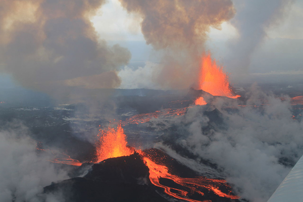
Vue de l’éruption de 2014-2015 (Crédit photo: Wikipedia)