Eruption sur l’île Fernandina (Iles Galapagos) // Eruption on Fernandina Island (Galapagos)

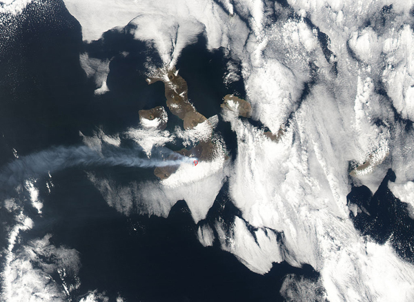
On attendait une éruption du Sierra Negra sur l’île Isabela aux Galapagos, mais c’est finalement La Cumbre sur l’île Fernandina qui déjoue les pronostics avec une nouvelle éruption ! La dernière avait eu lieu en septembre 2017. Après un épisode sismique avec des événements atteignant M 4.1, une nouvelle éruption a commencé vers 15 heures (TU) le 16 juin 2018.  Selon l’Instituto Geofisico, elle se situe sur le flanc nord-nord-est du volcan et se caractérise jusqu’à présent par l’émission de coulées de lave et une colonne de gaz s’élevant jusqu’à 3 km  de hauteur. La lave a déjà atteint l’océan.
Les habitants et les touristes sont invités à rester à l’écart, en particulier de la zone où les coulées de lave entrent dans l’océan, en raison de possibles explosions et d’une grande quantité de gaz toxiques.
Source: Instituto Geofisico
On peut voir des images de l’éruption sur le site web The Watchers:
https://watchers.news/2018/06/16/fernandina-volcano-erupts-lava-flow-reaching-the-ocean-galapagos/

—————————————-

One expected an eruption of Sierra Negra volcano but La Cumbre Volcano on Fernandina Isla,d was faster in the Galapagos ! After a seismic episode with events reaching M 4.1, a new eruption started at Fernandina volcano at about 15:00 UTC on June 16th, 2018. The volcano last erupted in September 2017.

According to the Instituto Geofisico, the eruption is taking place on the north-northeast flank of the volcano and is so far characterized by the emission of lava flows and a gas column rising up to 3 km. Lava has already reached the ocean.

Residents and tourists are advised to stay away, in particular from the area where lava flows are entering the ocean due to possible explosions and a large amount of toxic gas.

Source: Instituto Geofisico

Images of the eruption can be found on the website The Watchers:

https://watchers.news/2018/06/16/fernandina-volcano-erupts-lava-flow-reaching-the-ocean-galapagos/

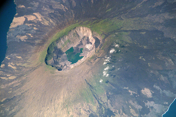
 La caldeira sommitale de l’île Fernandina vue depuis l’espace (Crédit photo: NASA)

Sierra Negra (Iles Galapagos) [suite / continued]

Voici quelques informations supplémentaires fournies par l’Instituto Geofisico sur son site web le 8 juin 2018 sur la situation du volcan Sierra Negra dans les Iles Galapagos. Vous trouverez des graphiques illustrant les informations à cette adresse:

http://www.igepn.edu.ec/islas-galapagos-informes/gal-sierra-negra/gal-sn-especiales/gal-sn-e-2018/20867-informe-especial-sierra-negra-n-4/file

Comme je l’ai écrit dans une note précédente sur la Sierra Negra, le nombre et la magnitude des séismes augmentent régulièrement depuis la moitié de l’année 2016. Cette augmentation de la sismicité s’accompagne d’une déformation très significative de l’édifice volcanique qui laisse supposer qu’une nouvelle éruption est possible dans quelques semaines ou quelques mois.
La sismicité est principalement volcano-tectonique, liée à la fracturation interne des roches. Cependant, un nombre important d’événements reflète des mouvements de fluides à l’intérieur du volcan. Depuis janvier 2018, il y a eu 11 séismes de magnitude supérieure ou égale à M 4.0. Les événements se situent principalement sur les bords de la caldeira, à l’exception de la lèvre NE, source des éruptions de 1979 et 2005.
Une importante déformation a été détectée par la station GV04 au centre de la caldeira tandis que la station GV01, située sur le bord extérieur de la caldeira, montre moins de déformation. Les données globales indiquent que la déformation continue sous la caldeira à faible profondeur.
Source: Instituto Geofisico, The Watchers. .

———————————————-

Here is some more information provided by the Instituto Geofisico on its website on June 8th, 2018 about the situation at Sierra Negra Volcano in the Galapagos Islands. You will find graphs illustrating the information at this address:

http://www.igepn.edu.ec/islas-galapagos-informes/gal-sierra-negra/gal-sn-especiales/gal-sn-e-2018/20867-informe-especial-sierra-negra-n-4/file

As I put it in a previous post about Sierra Negra, the number and magnitudes of earthquakes have been steadily increasing since mid-2016. This is happening together with very significant deformation suggesting a new eruption is possible in a matter of weeks or months.

Seismicity is mainly volcano-tectonic, related to internal rock fracturing. However, a significant number of events reflect fluid oscillations and movements inside the volcano. Since January 2018, there have been 11 earthquakes with magnitudes greater than or equal to M 4.0. The events are located mainly on the edges of the caldera, except its NE edge, the source of eruptions in 1979 and 2005.

Very large deformation has been detected at the GV04 station in the centre of the caldera while Station GV01, located on the outer edge of the caldera shows less deformation. The data suggest that deformation continues under the caldera at a shallow depth.

Source : Instituto Geofisico, The Watchers.

Evolution de la sismicité sur le Sierra Negra au cours des derniers mois

(Source: Instituto Geofisico)

Sierra Negra (Iles Galapagos / Galapagos Islands)

Selon le site web d’El Universo, le volcan Sierra Negra dans les îles Galapagos montre une hausse d’activité. La sismicité est en augmentation depuis janvier 2018 avec des événements allant jusqu’à M 4,8. La couleur du niveau d’alerte a été élevée à Jaune, ce qui signifie que l’accès à l’île Isabela est restreint. La persistance d’une sismicité élevée laisse supposer que le magma s’agite à l’intérieur du volcan, ce qui pourrait se solder par une éruption.
Les scientifiques ont installé un réseau sismique temporaire et deux inclinomètres numériques à proximité et à l’intérieur de la caldeira du Sierra Negra.
Le Sierra Negra est l’un des plus grands volcans des Iles Galapagos. Il possède une caldeira de forme ovale qui mesure 9 km d’est en ouest et 7 km du nord au sud. Il a produit au moins 10 éruptions dans l’époque historique, avec une période de repos moyenne de 15 ans entre chaque période éruptive. Ses deux dernières éruptions ont eu lieu en 1979 et 2005.
Source: El Universo.

———————————————–

According to the El Universo website, the Sierra Negra volcano in the Galapagos Islands is showing increased signs of activity. Seismicity has been increasing since January 2018 with events up to M 4.8 and the colour of the alert level has been raised to Yellow, which means that access to areas of Isabela Island is restricted. The persistence of high levels of seismicity suggests that magma is moving inside the Sierra Negra volcano, which could produce an eruption.

Scientists have installed a temporary seismic network and  two digital inclinometers in the surroundings and in the interior of the Sierra Negra volcano caldera.

Sierra Negra is one of the largest volcanoes in the Galapagos Islands and has an oval caldera, which measures 9 km east-west and 7 km north-south. It has produced at least 10 eruptions in the historical epoch, with an average resting period of 15 years between each eruptive period. Its last two eruptions occurred in the years 1979 and 2005.

Source : El Universo.

Image satellite des îles Galápagos en octobre 2005 lors de la dernière éruption du volcan Sierra Negra dont on aperçoit le panache. (Crédit photo : NASA)

Nouvelles de Fernandina (Iles Galapagos) // News of Fernandina Island (Galapagos)

D’après les derniers rapports émis par l’Institut de géophysique équatorien, l’activité a débuté sur l’île Fernandina le 4 septembre avec l’apparition se séismes hybrides qui ont évolué vers des événements longue période, eux-mêmes suivis de l’apparition du tremor éruptif qui annonçait la sortie de la lave. Cette dernière a été émise par une fracture en circonférence près de la lèvre SSO de la caldeira. Les coulées se sont dirigées vers le sud et le sud-ouest, sans toutefois atteindre l’océan. Un panache faiblement chargé en cendre montait jusqu’à 4 km au-dessus du cratère. Les coulées de lave ont continué à être actives le 5 septembre, avec une baisse d’activité en soirée. L’activité éruptive a chuté de manière significative le 6 septembre.

—————————–

According to Ecuador’s Instituto Geofisico (IG) latest reports, activity at Fernandina began on September 4th with the detection of hybrid earthquakes followed by long-period events, and finally the onset of tremor which heralded the beginning of the eruption. Lava emerged from a circumferential fissure near the SSW rim of the caldera and flowed down the S and SW flanks, with no evidence of the flows reaching the sea. A gas plume with low ash content rose 4 km above the crater rim. Lava flows continued to be active on September 5th but their intensity declined in the evening. Activity had decreased significantly by September 6th.