La mer d’Irminger, une partie cruciale de l’AMOC // The Irminger Sea, a crucial part of the AMOC

J’ai insisté à plusieurs reprises sur l’importance de la circulation méridienne de retournement de l’Atlantique (AMOC) pour réguler le climat et sur ce qui se passerait si cet énorme tapis roulant cessait de fonctionner. Dans une étude récente publiée dans Science Advances, des scientifiques ont identifié le moteur océanique qui joue le plus grand rôle dans la gestion des principaux courants atlantiques qui régulent le climat de la Terre.
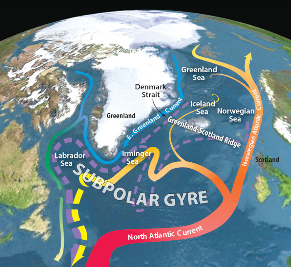
La mer d’Irminger, au sud-est du Groenland, est l’endroit où arrivent les eaux chaudes qui transportent la chaleur vers le nord depuis l’hémisphère sud, puis retournent vers le sud en s’enfonçant le long du fond de l’océan. En tant que telle, cette région joue un rôle essentiel dans le fonctionnement de l’AMOC. L’étude explique qu’il est urgent de mieux surveiller cette zone particulière.
L’AMOC, qui comprend le Gulf Stream, maintient un climat tempéré dans l’hémisphère nord et régule les conditions météorologiques à travers le monde. Toutefois, en raison du réchauffement climatique, l’AMOC pourrait ne pas maintenir les températures stables très longtemps. Les recherches montrent qu’en se déversant dans l’Atlantique Nord, l’eau de fonte de l’Arctique réduit la densité des eaux de surface et les empêche de s’enfoncer pour former des courants de fond. Cette situation ralentit le processus qui alimente l’AMOC.
La mer d’Irminger est particulièrement importante pour maintenir ces courants de fond. On peut lire dans l’étude que « l’arrivée d’eau douce dans cette région non seulement inhibe directement la formation d’eau profonde – essentielle pour maintenir la force de l’AMOC – mais cela modifie également les schémas de circulation atmosphérique. » Une réduction de la quantité d’eau qui s’enfonce dans la mer d’Irminger a probablement des impacts plus importants sur le climat de la planète que des réductions du même type dans d’autres mers du nord.
La mer d’Irminger a une influence très forte sur la force de l’AMOC car elle régule la quantité d’eau qui s’enfonce pour former des courants profonds dans les mers voisines par le biais de processus atmosphériques. L’apport d’eau douce dans la mer d’Irminger améliore le flux d’eau douce dans la Mer du Labrador entre le sud-ouest du Groenland et la côte du Canada, par exemple. Une réduction importante de la formation de courants profonds dans la mer d’Irminger aura des effets en cascade sur la formation de courants profonds dans tout l’Atlantique Nord.
Les auteurs de l’étude ont examiné l’impact de l’eau de fonte sur l’AMOC à l’aide d’un modèle climatique qui simulait une augmentation de l’apport d’eau douce dans quatre régions : la mer d’Irminger, la Mer du Labrador, les mers nordiques et l’Atlantique Nord-Est. Les chercheurs ont pu détecter la sensibilité de l’AMOC à l’eau de fonte dans chaque région, puis ils ont identifié des changements spécifiques du climat de la planète liés à chaque scénario. Le rôle de la mer d’Irminger pour l’AMOC a dépassé celui des trois autres régions du modèle et a déclenché des réactions climatiques plus fortes. La réduction de la formation d’eau profonde a entraîné un refroidissement généralisé dans l’hémisphère nord, ainsi qu’une expansion de la glace de mer arctique, car l’eau chaude n’arrivait plus en provenance du sud.
La simulation a également montré un léger réchauffement dans l’hémisphère sud et a confirmé les conclusions précédentes selon lesquelles un AMOC plus faible perturbait très fortement les systèmes de mousson tropicale.
Source : Live Science via Yahoo News.

Vue des courants océaniques dans la mer d’Irminger (Source : Oceanography)

—————————————————-

I have insisted several times on the importance of the Atlantic Meridional Overturning Circulation (AMOC) to regulate the climate and what would happen if this huge conveyor belt stopped working. In a recent study published in Science Advances, scientists have pinpointed the ocean engine with the biggest role in driving key Atlantic currents that regulate Earth’s climate.

The Irminger Sea off southeastern Greenland is where warm waters that transport heat northwards from the Southern Hemisphere sink and then return south along the bottom of the ocean. As such, this region plays a critical role in powering the AMOC. The study highlights the urgent need for better monitoring in this particular location.

The AMOC, which includes the Gulf Stream, maintains a temperate climate in the Northern Hemisphere and regulates weather patterns across the globe. But due to climate change, the AMOC may not keep temperatures stable for much longer. Research shows that Arctic meltwater gushing into the North Atlantic is reducing the density of surface waters and preventing them from sinking to form bottom currents, thus slowing the machine that powers the AMOC.

It turns out the Irminger Sea is particularly important for keeping these bottom currents flowing. One can read in the study that « freshwater release in this region not only directly inhibits deep-water formation — essential for maintaining the strength of the AMOC — but also alters atmospheric circulation patterns. » A reduction in the amount of water sinking in the Irminger Sea likely has greater impacts on the global climate than reductions of the same kind in other northern seas.

The Irminger Sea has a disproportionate influence on the strength of the AMOC because it regulates the amount of water sinking to form deep currents in nearby seas through atmospheric processes. Freshwater input into the Irminger Sea enhances freshwater flow into the Labrador Sea between southwestern Greenland and the coast of Canada, for example, so a reduction in deep-current formation in the Irminger Sea has knock-on effects for deep-current formation across the entire North Atlantic.

The authors of the study examined the impact of meltwater on the AMOC using a climate model that simulated an increase in freshwater input in four regions : the Irminger Sea, the Labrador Sea, the Nordic Seas and the Northeast Atlantic. The researchers were able to detect the sensitivity of the AMOC to meltwater in each region, then identified specific changes in the global climate linked to each scenario. The role of the Irminger Sea for the AMOC outweighed that of the three other regions in the model and triggered stronger climate responses. Reduced deep-water formation led to widespread cooling in the Northern Hemisphere, as well as Arctic sea ice expansion, because warm water was not being brought up from the south.

The simulation also showed slight warming in the Southern Hemisphere and bolstered previous findings that a weaker AMOC would throw tropical monsoon systems into chaos.

Source : Live Science via Yahoo News.

Faut-il s’attendre à un réchauffement stratosphérique soudain ? // Should we expect a Sudden Stratospheric Warming ?

Un réchauffement stratosphérique soudain (en anglais Sudden Stratospheric Warming ou SSW) est un phénomène météorologique pendant lequel le vortex polaire dans l’hémisphère hivernal voit ses vents généralement d’ouest ralentir ou même s’inverser en quelques jours. Un tel phénomène va rendre le vortex plus sinueux, voire le rompre. Le changement est dû à une élévation de la température stratosphérique de plusieurs dizaines de degrés au-dessus du vortex. Elle grimpe très rapidement, passant de -70/-80°C à -10/-20°C degrés (soit une élévation d’une soixantaine de degrés en quelques jours).  Pour rappel, la stratosphère est le couche atmosphérique située au dessus de celle où nous vivons – la troposphère – à une altitude située entre 10 et 50 km environ.

Durant un hiver habituel dans l’hémisphère nord, plusieurs événements de réchauffement mineur stratosphérique se produisent, avec un événement majeur se produisant environ tous les deux ans. Dans l’hémisphère sud, les SSW semblent moins fréquents et moins bien compris.

En conséquence, un réchauffement stratosphérique soudain et ses implications pour le vortex polaire peuvent avoir de sérieuses conséquences sur le climat de nos latitudes. L’air froid peut se retrouver piégé dans le jet stream (frontière entre l’air froid polaire et de l’air doux des tropiques) et être décalé jusqu’à nos latitudes, dans des régions peu habituées à un froid glacial, comme ce fut le cas en mars 2018 en Europe ou en février 2012 en France. Ces épisodes de SSW ne semblent toutefois pas avoir de relation avec le réchauffement climatique actuel ; ce sont de simples événements climatiques ponctuels.

Selon les météorologistes, il semble qu’un réchauffement stratosphérique soudain soit en préparation actuellement, avec un impact sur les conditions climatiques de l’hémisphère nord vers la mi-janvier avec l’arrivée d’un temps sec mais particulièrement froid à cause du blocage des hautes pressions par le vortex. Selon les météorologues, ces conditions froides devraient surtout affecter l’Europe du Nord et le Royaume Uni, alors que les conditions climatiques seront plus douces, humides et venteuses dans le sud de l’Europe.

La France devrait donc se trouver dans la zone tampon, avec des températures certes plus froides, mais pas extrêmement basses. De telles conditions semblent favorables à des chutes de neige.

Ces prévisions demandent toutefois confirmation et sont en grande partie régies par le comportement du vortex polaire, selon qu’il reste uniforme ou se brise en plusieurs morceaux.

Source: Météo France,The Weather Channel, The Watchers.

En cliquant sur ce lien, vous aurez une très bonne explication (en anglais) du réchauffement stratosphérique soudain et du comportement du vortex polaire.

https://youtu.be/VnlFFaF_l7I

————————————————

 A Sudden Stratospheric Warming (SSW) is a meteorological phenomenon during which the polar vortex in the winter hemisphere sees its generally westerly winds slow down or even reverse within a few days. Such a phenomenon will make the vortex more sinuous, or even break it. The change is due to a rise of several tens of degrees in stratospheric temperature above the vortex. It climbs very quickly, going from -70 / -80 ° C to -10 / -20 ° C degrees (an increase of about sixty degrees in a few days). As a reminder, the stratosphere is the atmospheric layer located above the one where we live – the troposphere – at an altitude between 10 and 50 km approximately.

During a typical winter in the northern hemisphere, several minor stratospheric warming events occur, with one major event occurring approximately every two years. In the southern hemisphere, SSWs appear to be less frequent and less well understood.

As a result, sudden stratospheric warming and its implications for the polar vortex can have serious consequences for the climate of our latitudes. Cold air can get trapped in the jet stream (border between cold polar air and mild tropical air) and be shifted to our latitudes, in regions not used to freezing cold, like this was the case in March 2018 in Europe or in February 2012 in France. However, these episodes of SSW do not seem to have any relation to current global warming; they are simple one-off climatic events.

According to meteorologists, it seems that a sudden stratospheric warming is in preparation now, with an impact on the weather conditions of the northern hemisphere around mid-January with the onset of dry but particularly cold weather due to the blockage of high pressures by the vortex. According to meteorologists, these cold conditions should mainly affect northern Europe and the United Kingdom, while the weather will be milder, wetter and windy in southern Europe. France should therefore be in the buffer zone, with temperatures certainly colder, but not extremely low. Such conditions seem favorable for snowfall.

These predictions require confirmation, however, and are largely governed by the behaviour of the polar vortex, whether it remains uniform or shatters into several pieces.

Source: Météo France,The Weather Channel, The Watchers.

By clicking on this link, you will get a very good explanation of the Sudden Stratospheric Warming and the behaviour of the polar vortex :

https://youtu.be/VnlFFaF_l7I

 Variables de comportement du vortex polaire dans l’hémisphère nord : stable, décalé, rompu  (Source: Met Office)

De moins en moins de neige dans l’hémisphère nord // Less and less snow in the northern hemisphere

drapeau francaisSelon les chercheurs du Global Snow Lab de l’Université Rutgers dans le New Jersey, l’ensemble de l’hémisphère nord au cours des quatre derniers mois (mars, avril, mai et juin) a connu le plus bas niveau de couverture neigeuse jamais enregistré pour cette période. Cela confirme les observations des 10 dernières années.
Pour l’année en cours, la couverture neigeuse moyenne pour les mois de mars, avril, mai et juin a été inférieure d’un peu plus de 500 000 kilomètres carrés au record précédent enregistré en 1990. Ce manque de neige pour l’hémisphère nord n’est pas le même pour tous les mois mentionnés, même si le niveau reste dans l’ensemble très faible. Mars a été le deuxième plus bas niveau jamais enregistré ; avril est le record absolu ; mai a été le quatrième plus bas et juin le troisième plus bas.
Cette faiblesse de l’enneigement fait partie de la tendance de notre planète à se réchauffer. Selon les chercheurs du Global Snow Lab, le phénomène aura des conséquences inquiétantes pour l’approvisionnement en eau, les feux de forêt et le réchauffement de la Terre elle-même. En effet, la faible couverture de neige signifie que la Terre a un pouvoir réfléchissant – ou « albédo » – moindre et elle se réchauffe davantage sous l’effet des rayons du soleil. Un fait montre parfaitement les conséquences du faible enneigement cette année ; c’est l’énorme incendie qui a dévasté la ville de Fort McMurray au Canada.
Le record ou quasi-record de faible enneigement dans l’hémisphère Nord pour les quatre mois mentionnés montre que le phénomène a été constant et a même progressé en latitude en allant vers le nord.

Les derniers chiffres concernant la perte de couverture neigeuse vont de pair avec les données sur la perte de glace de mer dans l’Arctique – la contrepartie de la couverture neigeuse sur les océans de l’hémisphère nord. La glace de mer a, elle aussi, battu des records de faiblesse cette année. Elle a été au plus bas pendant les mois de janvier, février, avril et mai. Le National Snow and Ice Data Center basé à Boulder dans le Colorado a indiqué que juin 2016 avait également battu un record pour l’étendue moyenne de la banquise arctique.
Source : Global Snow Lab.

————————————–

drapeau anglaisAccording to researchers with the Rutgers University Global Snow Lab, the entire Northern Hemisphere over the past four months (March, April, May and June) featured the lowest levels of snow cover ever recorded for this particular time period. It goes along with the pattern we’ve been seeing the last 10 years or so.

Overall, in 2016, the average snow cover across March, April, May and June was just over half a million square kilometres smaller than the previous record low year, 1990. Not every month during the four-month time period saw a record low for the Northern Hemisphere, but all were quite low. March was the second lowest on record, April was the absolute lowest on record, May was the fourth lowest and June was the third lowest.

This is part of a trend to be expected on our warming planet. That trend will have vast consequences for water supplies, wildfires and the warming of the Earth itself. Indeed, low snow cover means that the Earth has less reflectivity or « albedo » – so it warms up more from the sun’s rays. An indicator of the consequences of low snow so far this year is the enormous and devastating wildfire that engulfed Fort McMurray in Canada.

The record or near record low amounts of northern hemisphere snow in March, April, May and now June show there has basically been no reprieve and the phenomenon progressed farther and farther north, at higher and higher latitudes.

The latest numbers on snow cover come paired with data suggesting that Arctic sea ice – the counterpart to snow cover over the northern hemisphere oceans – has also set repeated record lows this year. January, February, April and May of this year all saw record lows for Arctic sea ice extent. The National Snow and Ice Data Center in Boulder, Colorado, has announced that June of 2016, too, saw record low average Arctic sea ice extent.

Source : Global Snow Lab.

Snow

Ce graphique montre que l’étendue de la glace de mer pendant le mois de juin a diminué d’environ 3,7% par décennie au cours de la période allant de 1979 à 2016 (National Snow and Ice Data Center).