Faut-il croire les bisons de Yellowstone? // Should we trust the bison of Yellowstone?

drapeau francaisLe séisme de M 4,8 qui a secoué Yellowstone dimanche dernier n’aurait certainement pas attiré l’attention du public si une vidéo montrant un troupeau de bisons en train de courir le long d’une route n’avait pas été publiée sur YouTube (voir ma note du 2 Avril). Suite à cette vidéo, certaines personnes ont affirmé que les animaux fuyaient parce qu’ils sentaient qu’une éruption majeure allait se produire. Il a suffi de cela pour que d’autres personnes expliquent les effets désastreux qu’une telle éruption aurait pour les Etats-Unis et l’ensemble de la planète. « Hiver nucléaire » et « extinction de masse » étaient des expressions fréquentes dans les articles de journaux et dans les commentaires.
De telles affirmations ont le don de me taper sur les nerfs ! Elles sont formulées par des personnes qui, pour beaucoup, ne savent même pas où Yellowstone est situé sur une carte des Etats-Unis. La plupart d’entre elles n’ont jamais mis les pieds à Yellowstone. Autrement, elles sauraient qu’il est assez fréquent de voir un troupeau de bisons se mettre à courir sans raison particulière. A titre personnel, j’ai connu une telle expérience il y a quelques années dans le Parc quand j’ai été pris au dépourvu par un troupeau de ces animaux qui venait de nulle part. Je me suis retrouvé rapidement au beau milieu des bisons, priant pour ne pas être piétiné !
Jake Lowenstern, responsable scientifique de l’Observatoire Volcanologique de Yellowstone, dit qu’il a visionné quelques-unes des vidéos de YouTube mais ne les trouve pas très convaincantes. Certaines ne semblent pas avoir été filmées récemment. Il ajoute que « même si le film est récent, toute personne qui a séjourné à Yellowstone a vu courir les bisons le long des routes à l’intérieur du Parc, pénétrer dans le parc ou en sortir. Un simple coup de klaxon suffit pour les faire courir « .
Comme je l’ai écrit auparavant, le séisme de dimanche s’est produit à environ 6,5 kilomètres au nord -nord-est du Norris Geyser Basin. Il avait une origine tectonique – donc non volcanique – et fait partie de l’activité sismique habituelle à Yellowstone.
Vous pouvez aller visiter ce merveilleux parc cet été sans craindre une éruption volcanique !

 ——————————————-

drapeau anglaisThe M 4.8 earthquake that struck Yellowstone last Sunday would certainly not have drawn public attention if a video showing bison running along a road had not been released on You Tube (see my note of April 2nd). Watching the video, some people pretended the animals were fleeing because they could feel a major eruption was going to happen. This was enough to have other people explaining the disastrous effects such an eruption would have for the U.S. and the whole planet.  “Nuclear winter” and “mass extinction” were frequent expressions to be read in the newspaper articles and in the comments that followed them.

Such statements are getting on my nerves! They are made by people who, for most of them, do not even know where Yellowstone is located on a map of the United States. Most of them have never visited Yellowstone. If they had, they would know that it is quite common to see a herd of bison running with no special reason. Personally, I had to face such an experience a few years ago in the Park when I was caught by surprise by a herd of these animals that came running from nowhere. I rapidly found myself right in the middle of the herd, praying not to be trampled on!

Jake Lowenstern, scientist in charge of the Yellowstone Volcano Observatory, says he has seen some of the YouTube videos but does not find them very convincing. Some do not appear to have been filmed recently. He adds that “even if the footage is new, anyone who has spent time at Yellowstone has seen bison running along the roads … into the park, out of the park, and within the park. A horn honking is enough to get them running. »

As I put it before, Sunday’s earthquake occurred about 6.5 km north-northeast of the Norris Geyser Basin. It had a tectonic – and non volcanic – origin and is part of the seismic activity most often recorded at Yellowstone.

You can go and visit this marvellous park this summer without fearing a volcanic eruption!

Bisons-Yell-01

Bisons-Yell-02

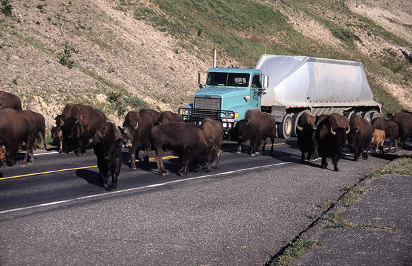
Les bisons de Yellowstone  (Photos:  C. Grandpey)

Séisme à Yellowstone // An earthquake hit Yellowstone

drapeau francaisUn séisme de M 4,8 a secoué le Parc de Yellowstone dimanche matin sans toutefois causer de dégâts. Un scientifique de l’Observatoire a indiqué que la secousse, ressentie à 6h34, avait été localisée pratiquement au centre du Parc, à proximité du Norris Geyser Basin et qu’elle n’était pas annonciatrice d’une activité volcanique.

Des  séismes de faible intensité sont observés quotidiennement à Yellowstone mais le dernier en date est le plus fort depuis 1985. A l’automne de celle année-là, on avait enregistré un essaim sismique avec un événement de M 4,9.

 ———————————————

drapeau anglaisA 4.8 magnitude earthquake rocked Yellowstone National Park early Sunday, but there were no immediate reports of damage. A scientist for the Yellowstone Volcano Observatory said the quake, which hit at 6:34 a.m. local time, was centered almost in the middle of Yellowstone National Park, near the Norris Geyser Basin and that it was not expected to trigger any volcanic activity.

Minor earthquakes are recorded daily at Yellowstone but the latest event was the most powerful to hit the park since 1985. During the autumn of that year, there was a seismic swarm with a maximum event of M 4.9.

Yellowstone-Norris

Vue du Norris Geyser Basin, l’une des zones les plus chaudes du Parc de Yellowstone.

(Photo:  C.  Grandpey)

Il y a 50 ans, l’Alaska tremblait… // 50 years ago, Alaska was trembling…

drapeau francaisLe 27 mars 2014 marque le 50ème anniversaire du séisme qui a secoué l’Alaska en 1964, le jour du Vendredi Saint. Connu sous le nom de « Great Alaskan Earthquake » ou « Good Friday Earthquake », d’une magnitude de M 9,2, c’est par sa puissance le deuxième séisme jamais enregistré sur notre planète, après celui de Valdivia au Chili en 1960, avec une magnitude de M 9,5. L’épicentre a été localisé à environ 90 km à l’ouest de Valdez et 120 km à l’est d’Anchorage, à une profondeur de 25 km. Le bilan officiel de la catastrophe se situe entre 115 et139 morts, victimes pour la plupart d’effondrements de bâtiments ou du tsunami engendré par le séisme. C’est ainsi que 32 personnes ont perdu la vie à Valdez, petit port blotti au bord du Prince William Sound et reconstruit aujourd’hui sur un site censé être plus sûr.

Le séisme du Vendredi Saint a marqué les esprits des Alaskiens et les témoignages se transmettent de génération en génération, un peu comme une alliance de mariage dont les bords auraient été un peu usés par le temps.

Tout a commencé à 17h36. Certains habitants d’Anchorage entendirent ce qui ressemblait aux chenilles de chars d’assaut, comme si toute une armée était en train de pénétrer dans la ville. D’autres eurent l’impression qu’un Boeing 747 était en train d’atterrir dans leur jardin. C’était comme si la grosse caisse d’une fanfare vibrait dans leur poitrine et comme si cette vibration se propageait dans tout leur corps. Pendant trois à cinq minutes selon les endroits, la terre ressemblait à une immense couverture que quelque géant était en train de secouer. Les arbres vacillaient ; poteaux et lignes électriques remuaient dans tous les sens. Dans les parkings, les voitures étaient soulevées de terre et retombaient les une contre les autres.

Puis les secousses cessèrent. Ce fut l’heure de constater les dégâts, d’établir des bilans et de penser à la reconstruction. De nombreux bâtiments s’étaient en partie ou en totalité effondrés. Il n’y avait plus d’électricité et de téléphone. Les conduites d’eau avaient été brisées. Les gens remplissaient les baignoires avec de la neige pour avoir de l’eau et le feu dans les cheminées remplaçait les appareils de chauffage. Comme toujours dans le cas de puissants séismes, celui du 27 mars 1964 fut suivi de répliques. A chacune d’elles, les gens sortaient précipitamment des maisons, en proie à la panique.

Ancho 01

La 4ème Avenue d’Anchorage juste après le séisme  (Crédit photo: U.S. Army)

Aujourd’hui encore, l’Alaska connaît des séismes, pas toujours ressentis par la population. Toutefois, dès qu’un grondement se fait entendre, comme celui d’un avion ou d’un chasse-neige, beaucoup d’habitants tendent l’oreille et restent vigilants, dans la crainte que se reproduise le séisme du Vendredi Saint.

Les traces du 27 mars 1964 ont disparu d’Anchorage mais plusieurs lieux rappellent ce terrible événement. Au nord de la ville, on peut visiter l’Earthquake Park où des panneaux fournissent des explications sur les glissements de terrain dévastateurs et meurtriers provoqués par les secousses.

Good-Friday-01

Dans le l’Alaska Experience Theater, un simulateur fait vibrer les spectateurs avec la même intensité qu’en 1964. Les images projetées sur l’écran font froid dans le dos.

Plus au sud, à Valdez, là où se trouvait le port avant le tremblement de terre et le tsunami, un panneau explique où se trouvaient les habitations.

https://claudegrandpeyvolcansetglaciers.com/wp-content/uploads/2016/02/v-01.jpg

https://claudegrandpeyvolcansetglaciers.com/wp-content/uploads/2016/02/v-02.jpg

(Photos:  C.  Grandpey)

Le Valdez Museum met en vente un DVD très intéressant, intitulé « Between the Glacier and the Sea », qui fait revivre les événements du Vendredi Saint 1964.

 ———————————————-

drapeau anglaisMarch 27th, 2014 marks the 50th anniversary of the earthquake that rocked Alaska in 1964, on Good Friday. Known as the  » Great Alaskan Earthquake  » or  » Good Friday Earthquake  » with a magnitude of M 9.2, it is the second most powerful earthquake ever recorded on our planet, after the one that shook Valdivia in Chile in 1960, with a magnitude of M 9.5. The epicentre was located about 90 km west of Valdez and 120 km east of Anchorage, at a depth of 25 km. The official toll of the disaster is between 115 et139 deaths, mostly victims of building collapses or of the tsunami generated by the earthquake. 32 people lost their lives in Valdez, a small port nestled on the shores of Prince William Sound and rebuilt today on a site supposed to be a safer.

The Good Friday Earthquake remains stamped in the minds of Alaskans and the memories are transmitted from generation to generation, like a wedding ring whose edges were a bit worn out with the time.
It all started at 17h36. Some residents of Anchorage heard what sounded like the caterpillars of tanks, as if a whole army was entering the city. Others got the impression that a Boeing 747 was about to land in their garden. It was as if the bass drum of a band vibrated in their chests and as if that vibration was spreading throughout their body. For three to five minutes depending on the area, the land looked like a huge blanket that a giant was shaking. Trees swayed ; poles and power lines were moving in all directions. In parking lots, cars were lifted from the ground and fell against one another.
Then the shaking stopped. It was time to see the damage, count the victims, establish budgets and think about reconstruction. Many buildings were partially or totally destroyed. There was no electricity and telephone. Water pipes were broken . People filled their bathtubs with snow for having water and fires in the fireplaces replaced the heaters. As always in the case of powerful earthquakes, the quake of March 27th 1964 was followed by aftershocks. At each of them, the people left hurriedly houses in a panic.
Today , Alaska is still experiencing earthquakes, not always felt by the population. However, when a rumbling sound can be heard, like an airplane or a snowplow, many people listen carefully and remain vigilant, fearing a repeat of the Good Friday Earthquake.
Traces of March 27th, 1964 have disappeared from Anchorage but many places recall this terrible event. North of the city, you can visit the Earthquake Park where signs provide explanations about the devastating and deadly landslides. (see photos above)
In the Alaska Experience Theater , a simulator shakes the audiences with the same intensity as in 1964. The images on the screen send shivers down the spine.
Further south, in Valdez, on the site where the port lay before the earthquake and tsunami, a sign indicates where the houses stood while a plaque bears the list of the missing (see photos above).
The Valdez Museum sells a very interesting DVD, entitled  » Between the Glacier and the Sea « , which meminds us of the events of Good Friday 1964.

Séisme en Nouvelle Zélande // An earthquake in New Zealand

drapeau francaisCe n’est pas volcanique mais ça s’est passé dans l’Ile du Nord de la Nouvelle Zélande où les volcans ne sont jamais très loin. Un séisme de M 6,2 a frappé la partie sud de l’île hier après-midi, près de la petite ville d’Eketahuna. On ne déplore aucune victime mais une série de dégâts matériels: chutes de bibelots, étagères qui lâchent prise et coupures de courant.

La partie centrale de l’île a subi une série de répliques aujourd’hui. L’événement le plus significatif avait une magnitude de 4,2, à une dizaine de kilomètres au NO de Castle point.

drapeau anglaisIt is not volcanic but it took place in New Zealand’s North Island where volcanoes are never far away. An M 6.2 earthquake struck the lower part of the island yesterday in the afternoon near Eketahuna. There were no casualties but quite a lot of broken ornaments, collapsed shelves and power outages.

The central North Island continues to be shaken with a series of aftershocks. The largest was a M 4.2 event, located 10 kilometres north-west of Castlepoint.