 Jusqu’à présent, la théorie généralement acceptée sur les origines de Yellowstone est que le soi-disant supervolcan est né à partir d’un point chaud, autrement dit un panache mantellique émergeant des profondeurs de notre planète. Une récente simulation montre que l’hypothèse conventionnelle est probablement erronée. Il semblerait que le panache était dans l’incapacité d’atteindre la surface car il était bloqué par une ancienne plaque tectonique. Il s’agirait de la plaque Farallon, si l’on se réfère à une étude publiée en 2012. En effet, ce n’est pas la première fois que cette nouvelle approche de Yellowstone est diffusée par les revues scientifiques.
Les résultats de la simulation, la première de son genre à reproduire l’interaction complexe entre un panache mantellique et une plaque tectonique en train de s’enfoncer, ont été présentés le mois dernier dans Geophysical Research Letters.
Des géologues de l’Université de l’Illinois ont réussi à reproduire deux choses en laboratoire : d’une part, l’histoire de la tectonique des plaques dans la région et, d’autre part, l’image géophysique de l’intérieur de la Terre. Non seulement les chercheurs ont réussi à créer une vue en trois dimensions de l’intérieur de Yellowstone, mais ils l’ont fait sur les 40 derniers millions d’années, afin d’essayer de recréer les éruptions qui se sont produites aux États-Unis entre l’Oregon et le Wyoming. Cependant, ils ont constaté qu’il leur était impossible de recréer la plupart des éruptions récentes en raison de la présence d’une plaque qui avait été entraînée en profondeur dans le manteau terrestre il y a environ 100 millions d’années, époque où les plaques Pacifique et nord-américaine ont commencé à converger.
Selon les scientifiques, le manteau autour de la plaque en train de s’enfoncer a provoqué une très forte pression à l’avant de cette dernière. La simulation montre qu’il y a 15 millions d’années, cette pression est devenue tellement importante que la plaque a commencé à se déchirer. Le panache qui se trouvait en dessous est passé à travers la plaque, ce qui a entraîné d’énormes épanchements de lave qui semblent correspondre aux basaltes du plateau de Steens-Columbia River.
Malgré le trou béant dans le centre de la plaque, le panache n’a pas continué à passer à travers elle parce que le manteau était très visqueux. Au fur et à mesure que la plaque continuait à s’enfoncer, elle entraînait avec elle le manteau environnant ce qui, en fin de compte, a obstrué le trou et empêché le panache d’atteindre la surface pendant les 15 millions d’années qui ont suivi.
L’hypothèse privilégiée jusqu’à présent ne peut pas expliquer la suite d’éruptions volcaniques qui a eu lieu depuis les premiers vastes épanchements basaltiques, y compris la formation de la caldeira de Yellowstone qui s’est produite il y a seulement 2,1 millions d’années. En conséquence, il faudra trouver une nouvelle explication pour la formation de Yellowstone, ainsi qu’une source de chaleur supplémentaire! Un chercheur pense que cette source pourrait se trouver au niveau de la dorsale Juan de Fuca dans l’Océan Pacifique. Bien que cette dorsale se trouve aujourd’hui à près de 1600 kilomètres du point chaud de Yellowstone, elle aurait pu facilement affecter le milieu de la plaque nord-américaine. Comme il se trouve tout juste à l’ouest de la zone de subduction de Cascadia, le jeune plancher océanique plonge facilement sous la plaque nord-américaine. Il se peut, il y a plusieurs millions d’années, que certains événements aient fait apparaître une grande quantité de chaleur au sein de la plaque Juan de Fuca alors qu’elle s’enfonçait sous la plaque nord-américaine. Cela aurait fait apparaître un chapelet d’éruptions volcaniques et finalement contribué à former la caldeira de Yellowstone dans les Montagnes Rocheuses.
Quelle que soit l’origine du volcanisme de Yellowstone, la simulation démontre que les plaques tectoniques ont joué un rôle beaucoup plus important qu’on le pensait dans tout le volcanisme de cette région.
Source: Scientific American: http://www.scientificamerican.com/
———————————-
 Up to now, the common theory about the origins of Yellowstone was that the so-called supervolcano was born from a hotspot, in other words a mantle plume emerging from our planet’s core. But a new simulation shows that the conventional hypothesis was wrong. The plume could not have reached the surface because it was blocked by a slab from an ancient tectonic plate.
The simulation results of the model, which is the first to replicate the complex interaction between a mantle plume and a sinking slab, were detailed last month in Geophysical Research Letters.
Geologists at the University of Illinois built the model to replicate both the plate tectonic history of the surface and the geophysical image of Earth’s interior. Not only did the researchers create a three-dimensional view of Yellowstone’s interior, they did so over the past 40 million years in an attempt to re-create the eruptions that have dotted the U.S. from Oregon to Wyoming. However, they found it impossible to re-create most of the recent eruptions because of the presence of a slab which was driven deep into Earth’s mantle about 100 million years ago when the Pacific and North American plates began converging.
According to the scientists, the mantle flowed around the sinking slab causing pressure to build toward the front. Their model shows that 15 million years ago the pressure difference became too much to bear and the slab began to tear. The plume below pulsed through the slab, leading to massive outpourings of magma which appear consistent with the Steens–Columbia River flood basalts.
Despite the gaping hole in the center of the sunken slab, the plume did not continue to rise through it because the mantle is highly viscous. So as the slab continued to sink, it pulled the surrounding mantle down with it, ultimately sealing the hole and blocking the plume from reaching the surface for the next 15 million years.
The favoured hypothesis cannot explain the string of volcanic eruptions since those first flood basalts, including the formation of Yellowstone’s caldera, which happened only 2.1 million years ago. As a consequence, a new explanation for Yellowstone’s formation needs to be found, as well as an additional heat source for Yellowstone! One researcher thinks this could come from the Juan de Fuca Ridge in the Pacific Ocean. Although that’s almost 1,600 kilometers away from Yellowstone’s hotspot today, the ridge can easily affect the middle of the North American Plate. Because it lies just slightly west of the Cascadia subduction zone, the young seafloor is easily shoveled east beneath the North American Plate. So it is likely that some event, millions of years ago, spurred a lot of heat within the Juan de Fuca Plate, which was then shoveled underneath the North American Plate and swept along with that string of volcanic eruptions until it eventually helped form Yellowstone’s gaping caldera in the Rocky Mountains.
Whatever the origin of Yellowstone’s volcanism, the model makes it clear that slabs are much more important than previously thought.
Source: Scientific American: http://www.scientificamerican.com/
++++++++++
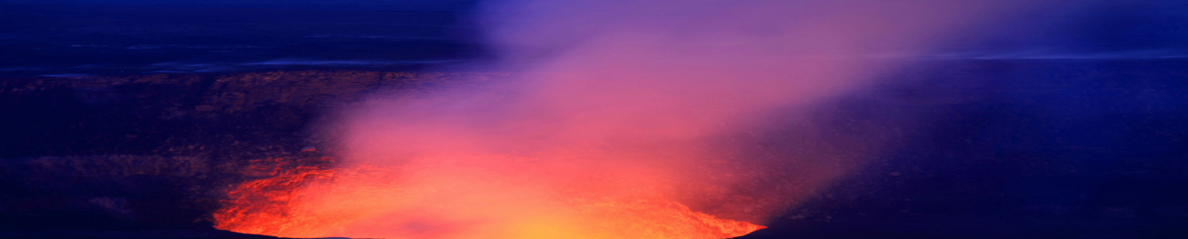
Voici quelques vues des épanchements basaltiques du plateau de la Columbia River:


Yellowstone possède également de belles structures géologiques:
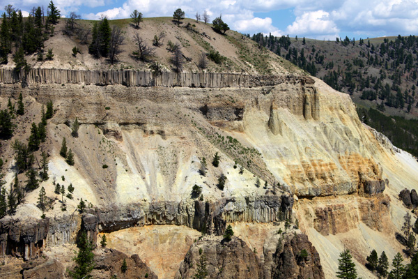


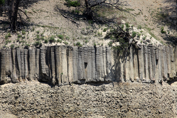

Photos: C. Grandpey


