 Dans son dernier rapport, l’Institut Géophysique (IG) fait le bilan de l’activité sur le Tungurahua en insistant sur son augmentation au cours des derniers jours.
Depuis Septembre, le volcan a montré une diminution de l’activité explosive, sismique et de dégazage (SO2). Cependant, ces derniers mois, il y a eu une augmentation de la pression interne qui s’est manifestée par un gonflement progressif de ses flancs supérieurs.
Le 8 décembre, on a observé une inversion de cette tendance et les inclinomètres ont montré une déflation de la zone sommitale.
A partir du 12 Décembre, on a enregistré une augmentation progressive de la sismicité, principalement dans le nombre de tremblements de terre associés à des mouvements de fluides et de tremblements de terre volcano-tectoniques associés à des fracturations.
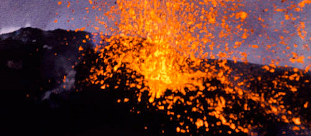
Le 14 décembre, à 14h35 (heure locale), un violent événement explosif perçu comme un coup de canon a généré une colonne de cendre qui est montée jusqu’à 6-7 km d’altitude. L’explosion a également donné naissance à des coulées pyroclastiques sur le flanc sud-ouest.
L’IG avance deux scénarii susceptibles d’expliquer cette dernière activité :
a) Une remontée rapide d’un petit volume de magma et la présence d’un bouchon de magma dégazé et solidifié qui a été détruit par la dernière explosion.
b) Une montée progressive d’un volume de magma depuis le mois de juillet de cette année. L’explosion a détruit un bouchon de magma dégazé et solidifié.
Photo de la dernière activité à cette adresse:
https://twitter.com/hehproycarcho/status/280287216817815552/photo/1/large
 In its latest report, The Geophysical Institute (IG) describes the recent activity of Tugurahua and insists on its increase during the past days.
Since September, explosive activity has decreased, as well as seismic activity and degassing (SO2).
However, during the last months, there has been an increase in the inner pressure that appeared through a progressive inflation of the upper flanks of the volcano.
On December 8th, there was an inversion of the tendency with tiltmeters showing a deflation of the summit area.
Starting on December 12th, seismicity gradually increased, with earthquakes related to fluid movements and volcano-tectonic events associated with rock fracturing.
On December 14th at 14:35 (local time) a powerful explosive event that was heard like a cannon ball generated an ash column up to 6-7 km a.s.l. The explosion also produced pyroclastic flows on the SW flank of the volcano.
IG explains that two scenarios may account for the latest activity:
1) The quick ascent of a small volume of magma and a plug of degassed and solidified magma that was destroyed by the last explosion.
2) A gradual magma ascent since July this year. The explosion destroyed a plug of degassed and solidified magma.
Photo of the latest activity at this address:
https://twitter.com/hehproycarcho/status/280287216817815552/photo/1/large
 En complément à ma note du 28 novembre sur le volcan équatorien, l’Institut Géophysique indique qu’un survol effectué le 23 novembre a permis d’observer – comme le montre l’image de la webcam – des panaches de gaz et de vapeur avec un peu de cendre d’une hauteur d’environ 500 mètres. Le dôme de lave montrait une intense activité fumerollienne et un nouveau cratère était apparu au sommet du dôme dont la température atteignait 300°C. Des coulées de lave étaient toujours actives sur les flancs du dôme et des dépôts de cendre et de blocs étaient également présents.
 In addition to my note of November 28th about Reventador, IG reports that scientists flew over the volcano on November 23rd. They could observe (as seen on the webcam images) steam-and-gas emissions with slight amounts of ash rising 500 metres above the lava dome. The dome had intense fumarolic activity and there was a new crater at the summit of the dome whose temperature reached 300°C. Lava flows continued to be active on the dome flanks; block-and-ash deposits were also visible on the flanks.
 D’après le SERNAGEOMIN, l’activité du Villarrica est restée faible au cours des dernières semaines. La sismicité s’est maintenue à un niveau bas avec des événements atteignant un maximum de M 1,2. Les émissions de SO2 sont restées stables. L’incandescence au niveau du cratère a faibli à partir de la mi-avril pour disparaître par la suite. Elle n’est plus détectée sur les images satellites, ni par les observateurs au sol.
 According to SERNAGEOMIN, activity at Villarrica remained weak during the past weeks. Seismicity was low with a maximum of M 1.2. SO2 emissions remained unchanged. Incandescence from the crater subsided in mid-April and was undetected by satellite and ground observations at least through November 10th.
 L’Institut Géophysique indique que le Reventador connaît une nouvelle phase d’activité depuis le mois de février 2012. On observe des coulées de lave émises par le cratère ainsi que des panaches de vapeur tandis que des anomalies thermiques apparaissent sur les images satellites. Les coulées de lave ont parcouru jusqu’à 2 km sur les versants N et S alors que les nuages de vapeur montent en général jusqu’à des hauteurs de 200 à 500 mètres. Des visites sur le terrain au cours des derniers mois ont confirmé que le dôme de lave continuait à croître dans le cratère. Son sommet dépasse maintenant la lèvre et est devenu le point culminant du volcan. Des blocs se détachent du dôme et des fronts de coulées et roulent sur les pentes du Reventador. Au cours des premiers jours de novembre, le réseau sismique a enregistré une hausse du tremor volcanique.
 The Instituto Geofisico indicates that last February Reventador began a new phase of activity characterized by lava flows from the crater, steam plumes, and thermal anomalies detected in satellite images. The lava flows travelled as far as 2 km down the N and S flanks, and steam plumes rose 200-500 metres above the crater. Field visits by volcanologists in recent months confirmed that the lava dome in the crater had continued to grow above the rim, becoming the highest point of the volcano. Blocks from the lava dome and lava-flow fronts rolled down the flanks. During the first days of November, the seismic network detected an increase in the magnitude of volcanic tremor.