 On parle beaucoup du vortex polaire ces jours-ci et des voix se font entendre prédisant une possible arrivée d’air très froid dans certaines parties de l’hémisphère nord en février 2023.
Comme je l’ai expliqué précédemment, le vortex polaire est une vaste zone de basse pression dans la haute atmosphère au-dessus des pôles. Il est particulièrement fort en hiver et plus faible en été. En fait, le vortex polaire consiste plutôt en une circulation de vents puissants -courants jet – qui sont très forts au niveau des pôles mais peuvent également atteindre des latitudes plus basses.
Un événement susceptible d’affecter le comportement du vortex polaire est un réchauffement stratosphérique soudain – Sudden Stratospheric Warming (SSW). Il se produit lorsqu’il y a une augmentation rapide de la température dans la stratosphère, la couche de l’atmosphère qui se trouve au-dessus de la troposphère. Cette augmentation de la température peut affaiblir ou même faire se briser le vortex polaire, ce qui peut avoir un impact significatif sur les conditions météorologiques dans l’hémisphère nord. Un tel événement se produit généralement en hiver et peut durer plusieurs semaines.
Au cours d’un SSW, les vents d’ouest qui circulent normalement autour du vortex polaire peuvent s’affaiblir ou même inverser leur direction, permettant à l’air froid de l’Arctique de s’échapper et de provoquer des entrées d’air arctique au-dessus de l’Europe, de l’Asie, du Canada et des États-Unis. Les effets d’un SSW peuvent également être ressentis à la surface, avec des températures plus froides et une forte probabilité de chutes de neige.
Il est important de noter que les événements SSW sont relativement rares ; ils se produisent en moyenne tous les 2 à 3 ans, mais ils deviennent plus fréquents ces dernières années avec le réchauffement climatique et l’augmentation des températures, en particulier dans l’Arctique. Il convient de noter que tous les SSW n’ont pas un impact majeur sur les conditions météorologiques ; certains d’entre eux sont mineurs et ont un effet limité.
Il est encore trop tôt pour prévoir ce qui se passera en février 2023. Les modèles météorologiques et les anomalies de température pointent vers un affaiblissement du vortex polaire et une possible entrée d’air froid dans l’hémisphère nord dans les semaines à venir.
Les températures dans la stratosphère sont à la hausse avec une vague de réchauffement qui se développe au-dessus de l’Arctique. Les prévisions actuelles tablent sur un événement SSW fort qui pourrait faire monter les températures stratosphériques à des niveaux record pour cette période de l’année.
L’un des modèles montre des anomalies chaudes qui envahissent la stratosphère au-dessus des régions polaires dans les premiers jours de février. Même si le vortex polaire est sévèrement affaibli et perturbé, il sera toujours présent. L’emplacement des descentes d’air froid dépendra de l’endroit où le vortex polaire se divisera ou se déplacera, ainsi que d’autres facteurs tels qu’El Niño ou La Niña qui ont une influence sur le temps à ce moment-là.
Un SSW mineur – qui semble le plus probable – est généralement moins susceptible qu’un SSW majeur d’avoir un impact sur les conditions météorologiques de surface. Cependant, un SSW majeur peut aussi se produire après un ou deux épisodes de réchauffement mineurs qui ont affaibli le vortex polaire, et il y a un certain risque pour que cela se produise. Au final, personne ne sait ce qui va se passer dans les semaines à venir…!
Il faut tout de même garder à l’esprit qu’un SSW en février 2018 a entraîné une vague de froid très sévère sur l’Amérique du Nord à la fin de ce mois-là et début mars. En revanche, le SSW de janvier 2019 n’a eu aucun impact significatif sur le Royaume-Uni et plus tard sur l’Europe. Celui de 2021, quant à lui, a entraîné une importante arrivée de froid dans une grande partie de l’Europe.
Source : The Weather Network.
—————————————–
 There is much talk about the polar vortex these days and voices can be heard predicting a possible arrival of very cold air in parts of the northern hemisphere in February 2023.
The polar vortex is a large area of low pressure in the upper atmosphere that typically sits over the Earth’s poles. It is a persistent and large-scale circulation pattern that is created by the cold temperatures at the poles. It’s strongest in the winter and weakest in the summer. Actually, the polar vortex is rather a series of circulating winds – jet streams – that are strongest at the poles but can also extend to lower latitudes.
One event likely to affect the behaviour of the polar vortex is a Sudden Stratospheric Warming (SSW). It occurs when there is a rapid increase in temperature in the stratosphere, the layer of the atmosphere above the troposphere. This increase in temperature can cause the polar vortex to weaken or even split, which can have a significant impact on weather patterns in the northern hemisphere. These events typically occur in the winter, and can last for several weeks.
During an SSW, the westerly winds that normally circulate around the polar vortex can weaken or even reverse direction, allowing cold Arctic air to escape and cause Arctic air outbreaks over Europe, Asia, Canada, and the United States. The effects of a SSW can also be felt at the surface, with colder temperatures and an increased likelihood of snowfall.
It’s important to note that SSW events are relatively rare, happening on average every 2 – 3 years, but they are becoming more frequent in recent years with global warming and the increase of global temperatures, especially in the Arctic. It is worth noting that not all SSWs lead to a major impact on weather patterns, some of them are minor and have a limited effect.
It is still too early to be sure of what will happen in February 2023. Weather models and temperature anomalies point towards a weakening of the polar vortex and the potential for cold air outbreaks in the northern hemisphere in the weeks ahead.
The temperatures in the stratosphere are already on the rise as a warming wave is developing over the Arctic. The current forecast calls for a strong event that could raise the stratospheric temperatures to record high levels for this time of year.
One of the models shows warm anomalies taking over the stratospheric polar regions in the first days of February. While the polar vortex will be severely weakened and disrupted, it will still be present. The location of cold air outbreaks may depend on where the polar vortex splits or displaces, as well as other factors such as El Niño or La Niña which influence the weather at the time.
A minor SSW, which is looking likely, is generally less likely to impact surface weather patterns than a major SSW. However, a major SSW can still occur after one or two minor warmings that weaken the polar vortex prior, and there is some support from ensembles for this to occur. In the end, nobody knows what will happen in the coming weeks… !
However, one should kep in mind that a SSW in February 2018 led to a verty severe cold snap over North America later that month and into early March, whereas the SSW in January 2019 had no significant impact for the UK and later Europe. The one in 2021, on the other hand, led to a significant cold outbreak event across much of Europe.
Source : The Weather Network.
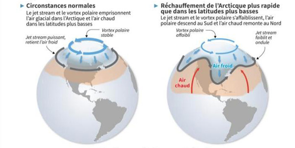
Vortex polaire stable et instable (Source: Météo France)