Hunga Tonga-Hunga Ha’apai (Tonga) : nouvelle éruption et tsunami

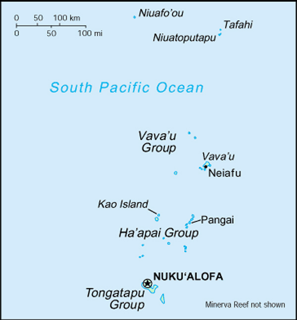
Selon plusieurs dépêches de presse, une nouvelle éruption a eu lieu sur le volcan Hunga Tonga-Hunga Ha’apai dans l’archipel des Tonga le 15 janvier 2022, déclenchant une alerte tsunami pour plusieurs nations insulaires du Pacifique Sud. Des images sur les réseaux sociaux ont montré des vagues qui s’écrasaient sur le rivage et contre des maisons.
Le Bureau australien de météorologie indique que l’éruption, qui se situe à environ 65 km au nord de Nuku’alofa, la capitale, a provoqué un tsunami de 1,2 mètre. L’agence continue de surveiller la situation mais aucune alerte tsunami n’a été émise pour le continent australien et les territoires voisins.

Des vagues de tsunami de 83 cm ont été observées par des jauges à Nuku’alofa et des vagues de 60 cm ont été enregistrées à Pago Pago, la capitale des Samoa américaines. L’alerte tsunami a ensuite été levée pour les Samoa américaines et Hawaï, mais reste une menace pour les parties du Pacifique les plus proches du volcan. Les Fidji ont également émis une alerte tsunami,et demandé à la population de ne pas s’approcher des côtes.
L’agence de gestion des risques en Nouvelle-Zélande a émis un avis de risque tsunami pour ses côtes nord et est. Ces zones sont susceptibles de connaître des courants forts et inhabituels et des épisodes de houle imprévisibles sur le rivage.
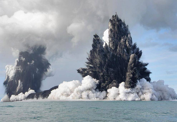
Comme je l’ai déjà écrit, le volcan Hunga Tonga-Hunga Ha’apai avait envoyé propulsé des nuages de cendres, de la vapeur et du gaz jusqu’à 20 km dans les airs le 13 juin 2022.
Source : Agences de presse internationales.

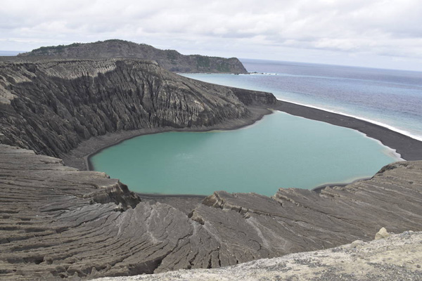
Vous trouverez de nombreuses illustrations sur le site web The Watchers.

Voici aussi l’éruption vue depuis l’espace :

—————————————-

According to several press reports, a new eruptionstarted Hunga Tonga-Hunga Ha’apai in the Tonga archipelago on January 15th, 2022, triggering a tsunami warning for several South Pacific island nations. Pictures on the social mediashowed waves crashing into homes.

The Australia’s Bureau of Meteorology indicates that theeruption, which is located about 65 km north of Nuku’alofa, caused a 1.2 metre tsunami. The agency continues to monitor the situation but no tsunami threat has been issued to the Australian mainland, islands or territories.

Tsunami waves of 83 cm were observed by gauges at the Tongan capital of Nuku’alofa and waves of 60 cm at Pago Pago, the capital of American Samoa. The U.S.-based monitor later cancelled warnings for the U.S. territory of American Samoa and Hawaii, but said the tsunami remained a threat for parts of the Pacific nearer the volcano. Fiji also issued a tsunami warning, urging residents to avoid the shorelines.

New Zealand’s emergency management agency issued an advisory on tsunami activity for its north and east coasts with the areas expected to experience strong and unusual currents, and unpredictable surges at the shore.

As I put it before,, the volcano had sent ash, steam and gas up to 20 km into the air on Junary 13th, 2022.

Source: International press agencies.

You’ll find numerous illustrations on the website The Watchers.

Hunga Tonga-Hunga Ha’apai (archipel des Tonga) : nouvelle éruption // New eruption

Selon le site web The Watchers, une puissante éruption a de nouveau eu lieu sur le volcan Hunga Tonga-Hunga Ha’apai (archipel des Tonga) le 13 janvier 2022. Le panache de cendres et de gaz s’est élevé à environ 16,7 km au-dessus du niveau de la mer, selon le Wellington VAAC.
Selon le service géologique des Tonga, l’éruption a duré plus de 12 heures. C’est la plus importante observée depuis décembre 2021. Des vagues de tsunami atteignant 30 cm ont été enregistrées à Nuku’alofa. Une alerte tsunami a été émise pour toutes les îles des Tonga; il a été conseillé aux habitants de s’éloigner de la côte. L’alerte a ensuite été annulée.

https://thumbs.gfycat.com/ChiefIllBasil-mobile.mp4

——————————————-

According to the website The Watchers, another powerful eruption started at Hunga Tonga-Hunga Ha’apai volcano (Tonga archipelago) on January 13th, 2022. The ash and gas plume rose up to about16.7 km above sea level, according to the Wellington VAAC.

According to the Tonga Geological Service, the eruption has lasted for more than 12 hours. it was the largest in a series of eruptions at the volcano since December 2021. Tsunami waves of up to 30 cm were recorded in Nuku’alofa. A tsunami warning was issued for all the islands of the Kingdom of Tonga, advising people to stay out of the water and away from the coast. The tunami warning was later cancelled.

Hunga Tonga-Hunga Ha’apai (archipel des Tonga / Tonga archipelago)

Dans une note publiée le 29 décembre 2021, j’indiquais qu’une nouvelle éruption avait débuté le 19 décembre à Hunga Tonga-Hunga Ha’apai dans l’archipel des Tonga, avec un panache de vapeur s’élevant jusqu’à 6 km d’altitude.
Le gouvernement des Tonga et le Wellington VAAC donnent plus d’informations sur cet événement. On peut lire que l’éruption a baissé d’intensité au cours des premiers jours de janvier 2022. Plusieurs épisodes surtseyens pouvant durer jusqu’à 30 minutes se sont produits au cours des derniers jours de décembre 2021 avec des panaches de gaz, de vapeur et de cendres s’élevant parfois à 12 km d’altitude Une décoloration de l’eau ainsi que des bancs de pierre ponce étaient visibles autour de l’île le 30 décembre et avaient déjà été observés depuis le début de l’éruption.
Quelques panaches de vapeur et de gaz étaient parfois visibles dans les données satellitaires les 1er et 2 janvier 2022.
La Smithsonian Institution explique que les petites îles de Hunga Tonga et Hunga Ha’apai constituent le sommet d’un volcan sous-marin situé à environ 30 km au SSE de Falcon Island. Les deux îles andésitiques de forme linéaire mesurent environ 2 km de long et représentent les vestiges ouest et nord de la lèvre d’une caldeira en grande partie immergée située à l’est et au sud des îles. Un haut-fond rocheux à 3,2 km au SE de Hunga Ha’apai et à 3 km au sud de Hunga Tonga marque le principal centre éruptif actif. Plusieurs éruptions sous-marines se sont produites à Hunga Tonga-Hunga Ha’apai depuis la première observée en 1912.
Je vous invite à lire plusieurs notes écrites à propos de Hunga Tonga-Hunga Ha’apai entre 2015 et 2017. Les derniers articles intitulés

« Hunga Tonga-Hunga Ha’apai : La naissance d’une île »
https://claudegrandpeyvolcansetglaciers.com/2019/02/09/a-la-decouverte-de-hunga-tonga-hunga-haapai-discovery-of-hunga-tonga-hunga-haapai/

« A la découverte de Hunga Tonga-Hunga Ha’apai »
https://claudegrandpeyvolcansetglaciers.com/2017/12/13/hunga-tonga-hunga-haapai-royaume-des-tonga-pacifique-sud-histoire-de-la-naissance-dune-ile-the-birth-of-an-island/

donnent plus de détails sur ces îles spectaculaires.

—————————————–

In a post released on December 29th, 2021, I indicated that a new eruption had started on December 19th at Hunga Tonga-Hunga Ha’apai in the Tonga archipelago, with a steam plume rising up to 6 km above sea level.

The Government of Tonga and the Wellington VAAC give more information about this event. One can read that the eruption decreased in the first days of January 2022. Several surges of Surtseyan activity, with some periods lasting as long as 30 minutes, occurred during the last days of December 2021 with gas, steam, and ash plumes rising at least to 12 km a.s.l. Discolored water and rafts of pumice were visible in areas around the island on December 30th, and had been observed since the beginning of the eruption.
A few steam-and-gas plumes were occasionally visible in satellite data on January 1st and 2nd, 2022. .

The Smithsonian Institution explains that the small islands of Hunga Tonga and Hunga Ha’apai cap a large seamount located about 30 km SSE of Falcon Island. The two linear andesitic islands are about 2 km long and represent the western and northern remnants of the rim of a largely submarine caldera lying east and south of the islands. A rocky shoal 3.2 km SE of Hunga Ha’apai and 3 km south of Hunga Tonga marks the most prominent historically active vent. Several submarine eruptions have occurred at Hunga Tonga-Hunga Ha’apai since the first historical eruption in 1912.

I invite you to read several posts I wrote about Hunga Tonga-Hunga Ha’apai betwen 2015 and 2017. The latest posts entitled

« Hunga Tonga-Hunga Ha’apai : The birth of an island »

A la découverte de Hunga Tonga-Hunga Ha’apai // Discovery of Hunga Tonga-Hunga Ha’apai

« Discovery of Hunga Tonga-Hunga Ha’apai »

Hunga Tonga-Hunga Ha’apai (Royaume des Tonga / Pacifique Sud) : Histoire de la naissance d’une île // The birth of an island

give more details about these spectacular islands.

Vue de l’arc Tonga-Kermadec

Crédit photo : NASA


La nouvelle île de l’archipel des Tonga (suite) // The new island of the Tonga archipelago (continued)

Comme je l’ai écrit dans une note précédente, une nouvelle éruption sous-marine a été détectée sur le volcan Metis Shoal (Iles Tonga), également connu sous le nom de Lateiki. Elle a donné naissance au banc de ponce observé à la surface de la mer en août 2019 L’éruption a finalement donné naissance à une nouvelle île à la fin du mois d’octobre. Elle se trouve à environ 120 mètres à l’ouest d’une ancienne île, aujourd’hui disparue. La nouvelle île mesure environ 400 mètres de long sur 100 mètres de large. Pour le moment, elle est trois fois plus grande que la précédente, mais comme elle est faite de pierre ponce, elle subira probablement les assauts de l’océan avant de disparaître elle aussi.

Le site Web The Watchers a publié de bonnes images de l’éruption et de la nouvelle île prises par le satellite Sentinel-2 de l’ESA. L’éruption a émis de volumineux panaches de vapeur, mais aucune trace de cendre n’a été identifiée par le VAAC de Wellington. .
Source: The Watchers.

——————————————

As I put it in a previous post, a new underwater eruption at Tongan Metis Shoal volcano, also known as Lateiki, the source of a massive amount of pumice detected in August 2019, resulted in the creation of a new island by the end of October. It was created about 120 metres west of a previous island which is now gone. The new island is about 400 metres long by 100 metres wide at the moment. As such, it is three times bigger than the previous one. As it is made of pumice, it will probably be washed away, just like the preceding ones.

The website The Watchers has released good images of the eruption and the new island taken by ESA’s Sentinel-2 satellite. The eruption emitted voluminous steam plumes and no ash was identified by the Wellington VAAC. .

Source : The Watchers.

L’éruption observée par le satellite SEntinel-2 le 30 octobre 2019