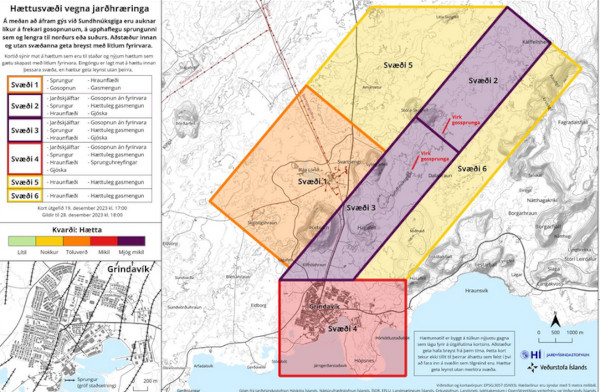
 Dans l’après-midi du 2 mars 2024, vers 16h00 (heure locale), une intrusion magmatique a été détectée par les instruments à 1 kilomètre à l’est de Sýlingarfell, après une intense activité sismique dans la zone. Selon le Met Office islandais, cette activité indiquait qu’une éruption était susceptible de se déclencher. Les habitants encore présents à Grindavik ont été évacués, ainsi que le Blue Lagoon. Les volcanologues s’attendaient à ce qu’une éruption se produise à l’est de Sýlingarfell. Ensuite, l’activité a semblé se déplacer vers le sud, en direction de Grindavik. Le magma semblait se trouver à une profondeur d’environ quatre kilomètres, ce qui pouvait signifier quelques heures, voire moins, avant une éruption.
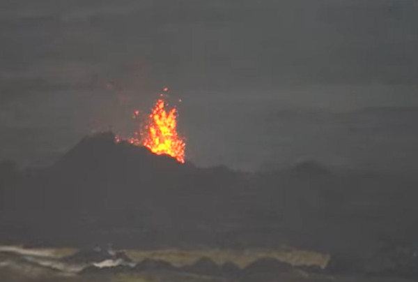
Puis, patatras ! Environ deux heures après son début, l’activité sismique a soudainement diminué, sans aucune indication que le magma était en train de remonter vers la surface. L’éruption a probablement avorté, phénomène que j’ai pu observer dans la région de Krafla dans les années 1990.
Aujourd’hui 3 mars au matin, la situation n’a pas évolué. La sismicité reste très faible sur la péninsule de Reykjanes. On va voir ce qui va se passer maintenant. Une fois de plus, nous constatons les limites de la prévision volcanique.
Il va falloir attendre un peu avant de voir la lave percer la surface….
———————————————–
 In the afternoon of March 2nd, 2024, at about 4:00 pm (local time), a magma flow had started 1 kilometre east of Sýlingarfell, following intense seismic activity in the area. The Icelandic Meteorological Office stated that the activity indicated that a volcanic eruption might start as a result. The residents still living in Grindavik were evacuated, as well as the Blue Lagoon. Avolcanic eruption was expected to occur east of Sýlingarfell. Next, activity seemed to be moving south, toward Grindavik. The magma appeared to be at a depth of approximately four kilometres, which could mean a few hours until an eruption, or even less time.
About two hours after it began, seismic activity suddenly decreased, with little indication that the magma was coming to the surface. Thee eruption may have aborted, a phenomenon that I could observe in the Krafla area in the 1990s.
Today March 3rd in the morning, the situation has not changed. Seismicity ids still very low on the Reykjanes Peninsula. Let’s see what will happen next. Once again, we can see the limits of volcanic prediction.