 La nuit dernière, l’éclipse de lune nous a offert un superbe spectacle.
————————————-
 Last night, the lunar eclipse offered us a great show.


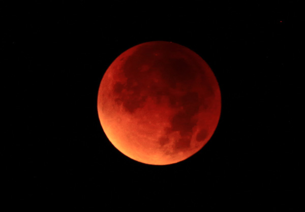

Photos: C. Grandpey

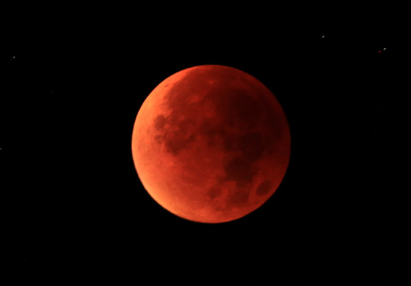
La nuit dernière, l’éclipse de lune nous a offert un superbe spectacle.
————————————-
Last night, the lunar eclipse offered us a great show.
Photos: C. Grandpey
Afin d’illustrer ce blog, j’ai inséré plusieurs galeries d’images dans la colonne de droite. Elles défilent en miniature. Pour faire apparaître l’une d’elles en taille d’origine (600 x 400 dpi), il faut cliquer sur l’image avec le bouton droit de la souris, puis sur « afficher l’image. » Il n’est malheureusement pas possible de voir directement l’ensemble de la galerie dans cette taille.
——————————-
In order to illustrate this blog, I have inserted several image galleries in the right-hand column. They can be seen in miniatures. To display one of them in the original size (600 x 400 dpi), you must click on the image with the right mouse button, then « display the image. » It is unfortunately not possible to directly see the whole gallery in this size.
 Si vous aimez l’Islande et les belles photos, je vous invite à visiter le site du photographe néerlandais Paul Oostveen. Vous pourrez admirer trois galeries de clichés consacrés à la côte, à l’intérieur du pays et aux rivières. Ils ont été réalisés depuis un hélicoptère ou un drone Phantom. Ces derniers ont été pris en juillet 2015 dans l’ouest et le nord de l’Islande.
http://luchtbeeld.nl/luchtbeeld/galleries/iceland/
Les drones sont de plus en plus utilisés pour la photo aérienne. Il est toutefois utile de rappeler que leur utilisation est soumise à des règles très strictes définies par la Direction de l’Aviation Civile. Le Journal de l’Ile de la Réunion a eu la bonne idée de le rappeler à l’occasion d’un survol photographique de l’éruption avec un drone il y a quelques jours.
————————————————————–
 If you like Iceland and nice photos, I invite you to visit the website of Dutch photographer Paul Oostveen. You will admire three galleries devoted to the coast, the land and the rivers. They were shot from a helicopter or a Phantom drone. The latter were taken in July 2015 in western and northern Iceland.
http://luchtbeeld.nl/luchtbeeld/galleries/iceland/
UAVs are increasingly used for aerial photography. However, it is worth remembering that their use is subject to strict rules defined by the Civil Aviation. The Journal de l’Ile de la Réunion had the good idea to remind it when a photo overflight of the eruption was performed with a drone a few days ago.
![]() En cliquant sur le lien ci-dessous, vous verrez une galerie de photos mise en ligne par le New York Daily News et qui résume bien la situation actuelle du Cotopaxi :
En cliquant sur le lien ci-dessous, vous verrez une galerie de photos mise en ligne par le New York Daily News et qui résume bien la situation actuelle du Cotopaxi :
– Le volcan émet encore de temps en temps des panaches de cendre.
– Des retombées de cendre affectent plusieurs localités où les habitants doivent porter des masques anti-poussière.
– Plusieurs villages ont été évacués préventivement, avec les problèmes que cela suppose, en particulier au niveau de l’approvisionnement en eau.
– Le sommet du volcan est recouvert d’une calotte de neige et de glace. En cas d’ascension du magma, des lahars pourraient menacer les environs du volcan où réside une population estimée à plus de 300 000personnes.
———————————————————-
 By clicking on the link below, you’ll see a gallery of photos released by the New York Daily News and that sums up the current situation of Cotopaxi:
– The volcano still emits still occasional ash plumes.
– Ashfall affects several communities where people should wear dust masks.
– Several villages were evacuated preventively, with the problems that this entails, particularly in terms of water supply.
– The summit area of the volcano is covered with a cap of snow and ice. In case of an eruption, lahars could threaten the surrounding area of the volcano with an estimated population of over 300 000 people.

Crédit photo: Wikipedia
